background image

36

36 


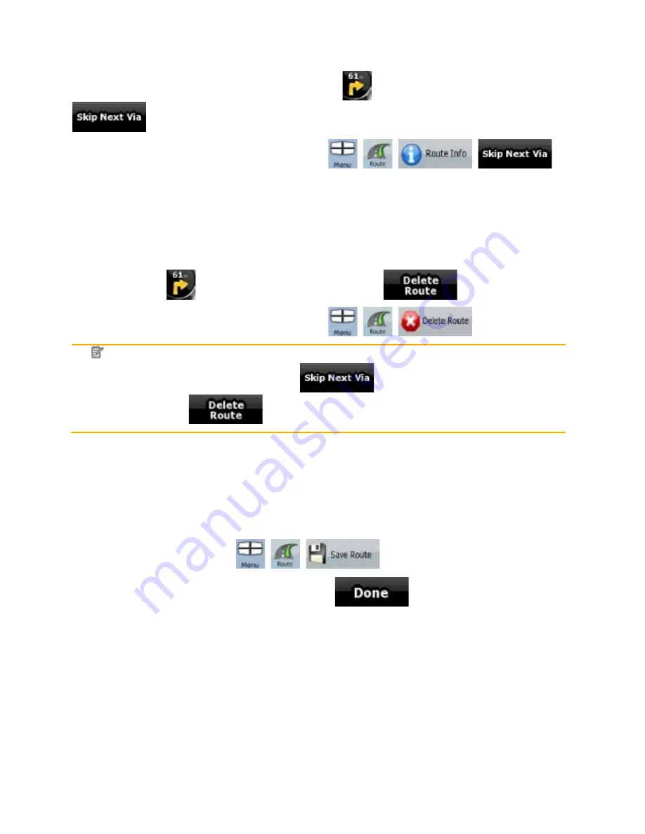
3.7 Deleting the next via point from the route 

The  easiest  way  to  delete  the  upcoming  route  point  (the  next  via  point)  is  to  open  the  Route 

Information screen by tapping the Turn Preview field (

) on the Map screen, and then tapping 

You have another option. Tap the following buttons:  

3.8 Deleting the active route 

The easiest way to delete the active route  is to open the Route Information screen by tapping the 

Turn Preview field (

) on the Map screen, and then tapping 

You have another option. Tap the following buttons:  

Note! 

If via points exist in the active route, you cannot delete the route immediately on the

Route Information screen. Tap 

 repeatedly until all via points disappear

and the 

 button appears. Tap it to cancel the whole route. 

3.9 Saving a route 

The procedure is explained starting from the Map screen. 

1.  Tap the following buttons:  

2.  Enter a name for the saved route, and then tap 

When you save a route, ZENEC Navigation Software not only saves the route points but the whole 

itinerary: 

x


The saved route might have been influenced by TMC information. When you later use the 

route, it appears as it was saved. But if it needs to be recalculated, the current TMC 

information will be used in the new route. 

x


If you updated your map since you first saved the route, ZENEC Navigation Software 

recognises the change, and recalculates the driving instructions according to the latest 

available map information. 

x


ZENEC Navigation Software deletes from the route any via points that you already left behind 

during navigation together with the road segments used to reach it. To avoid this, if you want to 

save the route, you need to save it before you start navigating. 

Summary of Contents for ZE-NA2000 -

Page 1: ...MODEL NO 1 CH DVB T TUNER ZE DVBT10 MODEL NO NAVIGATION SOFTWARE MANUAL English GPS NAVIGATION SYSTEM ...

Page 2: ... ZENEC 2008 ZENEC Data Source 2006 Tele Atlas N V Austria BEV GZ 1368 2003 Denmark DAV France IGN France Great Britain Ordnance Survey data with permission of Her Majesty s Stationery Office Crown Copyright Italy Geonext DeAgostini Northern Ireland Ordnance Survey of Northern Ireland Norway Norwegian Mapping Authority Public Roads Administration Mapsolutions Switzerland Swisstopo The Netherlands T...

Page 3: ...e first and start using ZENEC Navigation Software right away This document is the detailed description of the software You can easily discover ZENEC Navigation Software while you are using it however we still recommend that you read this manual to understand the screens and the features of ZENEC Navigation Software ...

Page 4: ... and recalculation 20 2 3 6 Itinerary 20 2 3 7 Route demonstration 21 2 3 8 POI Points of Interest 21 2 3 9 Speed limit warning 22 2 3 10 TMC Traffic Message Channel 22 3 Navigating with ZENEC Navigation Software 24 3 1 Selecting the destination of a route 24 3 1 1 Selecting the Cursor as the destination 24 3 1 2 Entering an address or part of an address 25 3 1 2 1 Entering an address Europe 25 3 ...

Page 5: ...wo route events Turn Preview fields 41 4 1 2 Objects on the map 42 4 1 2 1 Streets and roads 42 4 1 2 2 3D object types 43 4 1 2 3 Elements of the active route 43 4 1 3 Avoid menu 44 4 1 4 Cursor menu 44 4 1 5 Position menu 46 4 1 6 Route Information screen 46 4 1 7 Trip Information screen 47 4 1 7 1 Trip Computer screen 49 4 1 8 Quick menu 49 4 1 9 GPS Data screen 50 4 2 Find menu 51 4 3 Route me...

Page 6: ...6 6 4 5 6 TMC settings 61 4 5 7 Warning settings 62 5 Glossary 63 6 End User Licence Agreement 65 ...

Page 7: ...when it is safe to do so If you are the driver of the vehicle we recommend that you operate ZENEC Navigation Software before you start your journey Plan the route before your departure and stop if you need to change something in the route You must obey the traffic signs and follow the road geometry If you deviate from the route that ZENEC Navigation Software recommended ZENEC Navigation Software c...

Page 8: ...ns x Tap and hold on the Map screen you can set the minimum and maximum zoom level of Smart Zoom x Tap and hold any of the buttons on the Map screen you can set or reset the zoom value of the button 2D map x Tap and hold any of the buttons on the Map screen you can set or reset the tilt and zoom values of the button 3D map x Tap and hold on list and menu screens the Navigation menu appears x Tap a...

Page 9: ...n select your destination in the following ways x Use the selected location on the map the Cursor page 24 x Enter a full address or a part of an address for example a street name without a house number or the names of two intersecting streets page 25 x Enter an address with postal code page 30 This way you do not need to select the name of the settlement and the search for street names might be fa...

Page 10: ...oices a checkmark shows whether the feature is enabled Tap it to turn the switch on or off Virtual keyboard Alphabetic and alphanumeric keyboards to enter text and numbers Each key is a touch screen button 2 1 1 Using keyboards You only need to enter letters or numbers in ZENEC Navigation Software when you cannot avoid it You can type with your fingertips on the full screen keyboards and you can s...

Page 11: ...g the details of a map location x If you are interested in the details of your current position during navigation 1 Check the bottom line of the map It shows the current street and house number information 2 For further details tap to open the Position menu 3 Tap The address the coordinate and the list of nearby POIs will be displayed x You can check the details of any other location by selecting ...

Page 12: ...r finger to the direction in which you want to move the map If GPS position is available and you have moved the map the button appears Tap this button to return to the GPS position Opening closing map control buttons Tap this button to show or hide the following map control buttons x Zoom in out x Rotate left right 3D map only x Tilt up down 3D map only x Zoom preset buttons 2D map only x Tilt and...

Page 13: ...e always shows the mode the button switches to If you are in 2D mode you can see the button and you need to tap it to switch to 3D mode Smart Zoom ZENEC Navigation Software can automatically rotate scale and tilt the map and give you the optimal view x When you are approaching a turn ZENEC Navigation Software zooms in and raises the view angle to let you easily recognise your manoeuvre at the next...

Page 14: ...etails Action There is no active route If there is no route to be navigated this icon appears in the Turn Preview field Tap this area to open Find There is no valid GPS position If an active route exists and there is no valid GPS position the view of the sky above you is shown with coloured dots for each satellite Some dots need to turn green to be able to navigate Tap this area to open the Route ...

Page 15: ...n GPS position and an active route are both available this field shows the route event that follows the next route event shown in the above described area Tap this area to open the Itinerary screen with the turn by turn guidance instructions Stops the running simulation This icon appears during Route Simulation Tap this area to stop the simulation Route recalculation progress During route recalcul...

Page 16: ...direction of your heading both when the map is automatically rotated 3D and when the map is always facing North 2D Speed information There are speed values that can be shown x Current speed x Speed limit on the current road Time information There are time values that can be shown x Current GPS time x Time remaining to reach the destination x Time remaining to reach the next via point x Estimated a...

Page 17: ...tination while keeping the previous destination as a via point Shows the different routes calculated by the available routing methods Choose the one that suits your needs the best Saves the Cursor as a POI Saves the Cursor as a Favourite location Marks the map with a Pin at the Cursor Opens a screen with the name address and coordinate information of the Cursor and the list of POIs near it 2 3 ZEN...

Page 18: ...ection of the icon is one of the directions of the route To use the current GPS position tap The Position menu appears and you can save the GPS position as one of the following x a Favourite x a POI x a map marker Pin 2 3 2 2 Returning to normal navigation When GPS position is available and you have moved the map the icon is moving or is not even visible or you have rotated the map in 3D mode the ...

Page 19: ...e Cursor position the menu was opened with You can move and zoom the map and you can set the Cursor to a different place The usual Cursor appears and the buttons of the Cursor menu initiate actions for this new location To return to the original Cursor position tap The map jumps back to the position with which the Cursor menu was opened and the icon appears again 2 3 3 Daytime and nightcolour sche...

Page 20: ...route based on your preferences x Route calculation method x Fast x Short x Economical x Easy x Road types x Unpaved Roads x Permit Needed x Motorways x Toll Roads x Charge Roads x Ferries x Cross border Planning ZENEC Navigation Software automatically recalculates the route if you deviate from the proposed itinerary If your hardware supports TMC Depending on the type of the TMC event ZENEC Naviga...

Page 21: ...g the route Moves between pages for additional list items When the map is open with a manoeuvre in the middle Button Description Zooms in the map Zooms out the map Moves the map to show the previous or next manoeuvre Opens a screen where you can avoid a part of the route starting from the selected manoeuvre 2 3 7 Route demonstration A simulation drives you through the route following the driving i...

Page 22: ...r and additional information can be added to it Tap the following buttons 2 3 9 Speed limit warning Maps sometimes contain information about the speed limits of the road segments This information may not be available for your region ask your local dealer or may not be fully correct for all roads on the map You can configure ZENEC Navigation Software to warn you if you exceed the current limit Tap ...

Page 23: ...ill automatically search the FM radio stations for TMC data and the decoded information will immediately be used in route planning The moment ZENEC Navigation Software receives traffic information that may affect your route the program will warn you that it is recalculating the route and navigation will continue with a new route that is optimal considering the most up to date traffic conditions If...

Page 24: ...code page 30 This way you do not need to select the name of the settlement and the search for street names might be faster as well x Use a coordinate page 33 x Use a saved location x a Favourite page 31 x a POI page 32 x the History of previously set destinations and waypoints page 33 Tip If you are going to use a route later save it before you start navigating Tap the following buttons 3 1 1 Sele...

Page 25: ...ult ZENEC Navigation Software proposes the country and settlement where you are If needed tap the button with the name of the country and select a different one from the list 3 If needed change the settlement x To select the settlement from the list of recently used ones tap the button x To enter a new settlement 1 Tap the button with the name of the settlement or if you have changed the country s...

Page 26: ...ase after entering the house number you need to select the appropriate address by the district suburb information The procedure is explained starting from the Navigation menu 1 Tap the following buttons 2 By default ZENEC Navigation Software proposes the country state and settlement where you are If needed tap the button with the name of the country state and select a different one from the list 3...

Page 27: ...e district suburb Long roads can run across several districts or suburbs You may not know what particular house number is located where In this case follow the instructions below The procedure is explained starting from the Navigation menu 1 Tap the following buttons 2 By default ZENEC Navigation Software proposes the country state and settlement where you are If needed tap the button with the nam...

Page 28: ...ed one 7 The map appears with the selected point in the middle Tap from the Cursor menu The route is then automatically calculated and you can start navigating 3 1 2 4 Selecting an intersection as the destination The procedure is explained starting from the Navigation menu 1 Tap the following buttons 2 By default ZENEC Navigation Software proposes the country state and settlement where you are If ...

Page 29: ...e matching streets can be shown on one screen their list appears automatically 6 Tap the desired intersecting street in the list 7 The map appears with the selected point in the middle Tap from the Cursor menu The route is then automatically calculated and you can start navigating 3 1 2 5 Selecting a city centre as the destination The City Centre is not the geometric centre of the settlement but a...

Page 30: ...ring the postal code instead of the settlement name Find below an example with a full address The procedure is explained starting from the Navigation menu 1 Tap the following buttons 2 By default ZENEC Navigation Software proposes the country state and settlement where you are If needed tap the button with the name of the country state and select a different one from the list 3 Tap the button with...

Page 31: ...ommon or less usual name fewer letters are enough to find it x If one of the streets is shorter search for that one first You can then find the second one faster x You can search for both the type and the name of a road If the same word appears in several names for example in the name of streets roads and avenues you can obtain the result faster if you enter the first letter of the street type For...

Page 32: ...tour it adds to the active route This can be useful if you search for a later stopover that causes only a minimal detour for example upcoming petrol stations or restaurants 3 You can narrow the search with the following x Select the POI group e g Accommodation and after that if needed select the POI subgroup e g Hotel or Motel x To find the POI by its name tap and use the keyboard to enter a part ...

Page 33: ...entering its coordinates The procedure is explained starting from the Navigation menu 1 Tap the following buttons 2 optional Tap to change the format of the displayed coordinates 3 Tap the latitude or longitude value to change the coordinates 4 Enter the coordinate values in WGS84 format on the keyboard the latitude N or S and the longitude E or W 5 Tap 6 The map appears with the selected point in...

Page 34: ... point and all via points are to be reached in the opposite order than before The route is optimised The start point and the destination remain at their position but the via points are reordered to make the shortest possible route The selected point is removed from the route The route remains as it was before adding the new point Every time a new point is added the route is recalculated automatica...

Page 35: ...tination the destination becomes the start point and all via points are to be reached in the opposite order than before The route is optimised The start point and the destination remain at their position but the via points are reordered to make the shortest possible route The selected point is removed from the route As soon as you leave this screen the route is recalculated automatically and you c...

Page 36: ...route 3 9 Saving a route The procedure is explained starting from the Map screen 1 Tap the following buttons 2 Enter a name for the saved route and then tap When you save a route ZENEC Navigation Software not only saves the route points but the whole itinerary x The saved route might have been influenced by TMC information When you later use the route it appears as it was saved But if it needs to ...

Page 37: ...fferent from the current GPS position you need to confirm whether you want to stop navigating from the current GPS position to use the start point of the loaded route x If you choose this option automatic off route recalculation will be disabled x If you choose to keep the current GPS position as the start point the route will be recalculated starting from your current position 4 The map appears a...

Page 38: ...ry items and Saved Routes Settings Managing the behaviour of ZENEC Navigation Software for example the map layout during navigation the used languages or the warnings 4 1 Map screen ZENEC Navigation Software is primarily intended for land navigation That is why maps in ZENEC Navigation Software look similar to paper road maps However ZENEC Navigation Software provides much more than regular paper ...

Page 39: ...igating a route Opens the Position menu Cursor menu appears when there is no GPS position or the Cursor is not at the current GPS position Opens the Cursor menu Open Close Map control buttons Tap this button to show or hide the following map control buttons x Zoom in out x Rotate left right 3D map only x Tilt up down 3D map only x Zoom preset buttons 2D map only x Tilt and zoom preset buttons 3D m...

Page 40: ...ailable in 2D mode Tap hold any of the buttons to set its value to the current zoom level or to reset it to its original value Tilt preset buttons Tap one of the preset buttons to set the tilt and zoom levels to fix predefined values Smart Zoom is disabled These buttons are available in 3D mode Tap hold any of the buttons to set its value to the current tilt and zoom levels or to reset it to its o...

Page 41: ...4 1 1 2 Status indicator strip This is a multiple status indicator It indicates the following status information on a single strip Icon Description The sound output of ZENEC Navigation Software is muted The sound output of ZENEC Navigation Software is enabled No TMC receiver is connected or TMC is turned off A TMC receiver is connected and a radio station with TMC broadcast is received There are n...

Page 42: ...aching the destination In certain situations when route events are not important these fields show other useful pieces of information They are described here page 14 4 1 2 Objects on the map 4 1 2 1 Streets and roads ZENEC Navigation Software shows the streets in a way that is similar to how the paper road maps show them Their width and colours correspond to their importance you can easily tell a ...

Page 43: ...e route map in 3D when you navigate 4 1 2 3 Elements of the active route ZENEC Navigation Software shows the route in the following way Symbol Name Description Current GPS position Your current position displayed on the map This is not the exact GPS position The arrow is put on the nearest road Cursor selected map location The location selected in the Find menu or a map point selected by tapping t...

Page 44: ...ure sections of the route each of them becomes active when you reach the via point at its beginning Streets and roads that are excluded from the navigation You can choose whether you want to use or avoid certain road types page 58 However when ZENEC Navigation Software cannot avoid such roads the route will include them and it will show them in a colour that is different from the route colour 4 1 ...

Page 45: ...oints the route is deleted The Cursor is added to the active route as an intermediate route point a point to be reached before the destination If there is already a via point in the route the Edit Route screen opens to let you decide where the new via point is to appear in the route If the Cursor is at or near one of the via points this button replaces the previous one and deletes the selected via...

Page 46: ... the current GPS position the Position menu replaces the Cursor menu It does not contain buttons that modify the current route as the GPS position is not useful as a route point To open the Position menu tap 4 1 6 Route Information screen The Route Information screen has all the data and some of the functions you need while you navigate There are two ways to open this screen x It can be opened dir...

Page 47: ...ilable for the remaining segments of the route The calculation cannot take into account traffic jams and other possible delays Tap this field to change the content of all data fields to via point information Method This field shows how the route was calculated It displays the Route Calculation Method Fast Short Easy or Economical Tap this field to change the content of all data fields to via point...

Page 48: ...ng segments of the route The calculation cannot take into account traffic jams and other possible delays Tap this field to show it on the map screen in one of the Trip Data fields Arrival Time Shows the estimated arrival time at the final destination of the route based on information available for the remaining segments of the route The calculation cannot take into account traffic jams and other p...

Page 49: ...ip data It can be opened from the Trip Information screen by tapping The fields on this screen are continuously updated while you keep the screen open You can switch between the trips pause then resume them or reset their data You have the following functions on this screen Name Description Pauses the trip currently shown on the screen Values on the screen stop changing This button replaces the pr...

Page 50: ...he GPS receiver No action When a TMC receiver is connected to ZENEC Navigation Software this button opens the list of TMC messages and provides access to the TMC Settings and the radio station settings screens No action 4 1 9 GPS Data screen Tap the following buttons and then to open the GPS Data screen and to see the status of GPS reception Icon Colour Name Description Green GPS position quality ...

Page 51: ...llow satellites are only received while green ones are used by the GPS receiver to calculate your current location n a Coordinates Your current GPS position in WGS84 format n a Status bar for the satellites Dark bars are for the yellow and lit bars are for the green satellites The more satellites your GPS tracks the green ones the better is your calculated position 4 2 Find menu Select the destina...

Page 52: ...route you will have to rebuild it from scratch page 36 You can save the active route for later use page 36 You can load a previously saved route for navigation page 37 Opens the Route settings screen with controls to modify the vehicle the road types used for route calculation or the route calculation method page 58 You can run a demonstration of the route at normal speed 4 4 Manage menu You can m...

Page 53: ...ed item in the History Deletes the entire History Moves between pages for additional list items 4 4 3 Manage POIs You can manage your POIs and set POI visibility for both your POIs and the ones that came with the product Tap the following buttons Button Icon Description Button with the name of the POI group Opens the list of the subgroups of this POI group The new list behaves the same as this one...

Page 54: ...OI group will be shown on the map Subgroups under the edited POI group will inherit the visibility settings of the POI group Button with the icon of the POI group Tap this button to select a new icon for the POI group Deletes the edited POI group You are only allowed to remove POI groups that you have created When a POI item is open for editing Button Description Button with the name of the POI Ta...

Page 55: ... menu Tap this button to remove all your Pins from the map Backup User Data All user data and the current settings will be saved on the inserted memory card There is always one backup file If you perform a backup later the previous backup will be overwritten with the new information Restore User Data All user data and settings will be overwritten with the information stored in the backup file Data...

Page 56: ...he TMC receiver is working you can select the radio station to be received page 61 You can enable speed warning page 62 This screen has no navigation feature It merely provides information about the maps and licenses included with your navigation system 4 5 1 Map Screen settings You can fine tune the appearance and content of the Map screen Tap the following buttons Button Description 3D Settings ...

Page 57: ...contain lane information to help you position your car in the upcoming intersection This setting tells ZENEC Navigation Software whether to display this information at the top or at the bottom of the map 4 5 2 Navigation settings You can control how ZENEC Navigation Software behaves during navigation Tap the following buttons Button Description Keep Position on Road This feature allows car drivers...

Page 58: ...es they will be used but only as much as necessary In this case a warning icon will be shown on the Route Information screen and the part of the route not matching your preference will be displayed in a different colour on the map Route Calculation Method You can choose from different route types The routing method can also be chosen while creating the route when the destination is selected tap in...

Page 59: ...formation about the accessibility of temporary ferries You might also need to pay a fare on ferries Cross border planning In some cases the route calculated according to your other navigation and route preferences would lead through another country If you wish to always stay within the same country turn this option off Route Calculation Method types Option Description Fast Gives the quickest possi...

Page 60: ... Time and Time Zone Settings You can access time and time zone settings ZENEC Navigation Software helps you with correcting the device time to the ever accurate GPS time ZENEC Navigation Software can also help you set the time zone based on your current GPS position Time and Time Zone Settings Button Description Auto Time Correction to GPS Use this feature to synchronise the clock of your device t...

Page 61: ...Rate The communication speed used between the TMC receiver and the application Autodetect Tap this button and let ZENEC Navigation Software find and connect to the TMC receiver With a TMC receiver already connected the content of the screen is different Button Description Use Auto tuner If Auto tuner is enabled the tuner of ZENEC Navigation Software sweeps through the FM CCIR radio band searching ...

Page 62: ...ot be fully correct for all roads in the map This setting lets you decide whether you wish to receive the warnings You can set the relative speeding level at which the application warns you 100 represents the current speed limit x In Built up Areas in cities and towns x Elsewhere at all other locations There are two types of warnings You can turn them on or off independently x Audible Warning A vo...

Page 63: ...n in larger cities it is an important intersection GPS accuracy Several factors have impact on the deviation between your real position and the one given by the GPS device For example signal delay in the ionosphere or reflecting objects near the GPS device have a different and varying impact on how accurately the GPS device can calculate your position Map ZENEC Navigation Software works with digit...

Page 64: ... the final destination and the route is cut into different legs from one destination to the next Scheme ZENEC Navigation Software comes with different colour schemes for the map for daytime or night use Schemes are custom graphic settings for the map and they can have different colours for streets blocks or surface waters in 2D and 3D modes and they display shades or shadows in different ways in 3...

Page 65: ... applicable with specific reference to the Act No 4 of 1959 on the Civil Code CC and to Act No 76 of 1999 on Copyrights CA 3 2 This agreement is issued in NOTE TO TRANSLATOR PLEASE INSERT YOUR LANGAUGE and in Hungarian In case of dispute the Hungarian text shall prevail 4 The object of the Agreement 4 1 The object of this Agreement shall be the navigation guidance software product of Licensor here...

Page 66: ...data stored therein or to install it in other products utilise it in other products not even with the aim of achieving interoperability with other products 8 Non warranty limitation of responsibility 8 1 Licensor hereby informs the User that although the greatest care was taken in producing the Software Product yet with respect to the essence of the Software Product and the technical limitations t...

Page 67: ...he state before the breach to the expense of the person in breach and may claim the destruction of instruments and materials used for the breach and that of the objects created by the breach 9 1 6 claim damages 9 2 The Licensor hereby also informs the User that the breach of copyrights and related rights is a crime according to Act IV of 1978 on the Hungarian Criminal Code which may draw as a sanc...

Page 68: ...1 CH DVB T TUNER ZE DVBT10 MODEL NO ...

Reviews: