background image

49 


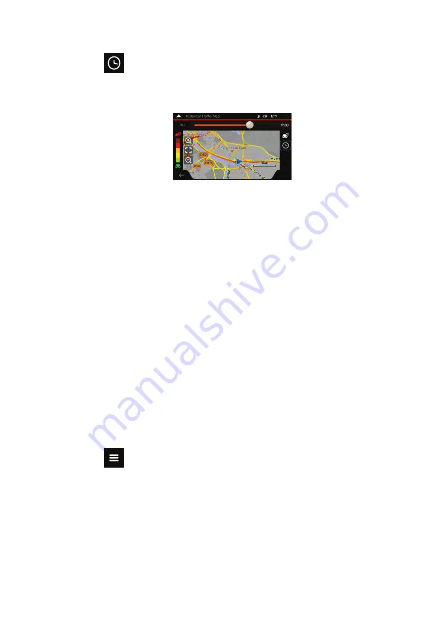
3.  Tap 

 to display historical traffic information. A 2D map is displayed with road 

segments coloured by the likely density of the traffic in the given period. The 

information relevant for the current period is shown when you open the screen. If 

necessary, you can browse the map for a better view of certain road segments. Modify 

the day of week and the time of day to see the desired period. 


3.4 Editing the route 

When navigation has already started, there are several ways to modify the planned route. 

You have the following options: 

  Setting a new starting point, see page 49 

  Adding an additional destination, see page 50 

  Modifying the list of destinations, see page 51 

  Saving the planned route, see page 51 

  Deleting the planned route, see page 52 

  Selecting a route alternative when planning the route, see page 52 

  Selecting a route alternative for an existing route, see page 53 

  Pausing guidance, see page 55. 

3.4.1 Setting a new starting point 

For normal navigation, all routes are calculated from the current position. You can pause 

navigation to check future routes, simulate them or see their length in time and distance. Then 

you can set the starting point of the route to a location other than the current GPS position. 

1.  Tap 

 on the 

Navigation view

 to access the 

Navigation menu

Summary of Contents for Z-N966

Page 1: ...INFOTAINER NAVIGATION USER MANUAL EN Z EMAP66 Series MOTOR HOMES...

Page 2: ...Motorway services 19 1 3 11 3D object types 19 1 3 12 Traffic events 20 1 4 Navigation menu 20 2 Warnings and safety information 23 3 Using the navigation 24 3 1 Selecting a destination 24 3 1 1 Using...

Page 3: ...3 4 9 Pausing guidance 55 3 5 Saving a location 55 3 5 1 Editing a saved location 56 3 6 Running a Simulation 57 3 7 Off road navigation 58 3 7 1 Switching to off road navigation 58 3 7 2 Selecting t...

Page 4: ...ngs 72 4 3 5 Regional settings 74 4 3 6 Display settings 75 4 3 7 Traffic settings 75 4 3 8 Trip Monitor settings 77 5 Troubleshooting 78 5 1 GPS signal cannot be received 78 5 2 Address cannot be fou...

Page 5: ...ware for the first time an initial set up process starts automatically 1 Select your preferred language then tap to confirm your selection Later you can change it in Regional settings page 74 2 Read t...

Page 6: ...s page 68 Tap to continue 7 The initial set up is now complete tap to enter the Navigation view 1 2 Screen controls The following sections describe the functionality and use of buttons sliders and oth...

Page 7: ...there are only two choices Tap it to turn the switch on or off Slider When a feature can be set to different values in a range ZENEC shows an indicator on a gauge that displays and sets the value Drag...

Page 8: ...ek or numerical Only those keyboard buttons are active that can be used to type a name that is available on the map The other keys are greyed out Action Function Switching to another keyboard layout f...

Page 9: ...and hold any of the following buttons on the Navigation view to rotate tilt or scale the map continuously Tap and hold the following button on keyboard screens to quickly delete several characters Dra...

Page 10: ...e map is displayed on the screen ZENEC uses maps that let you examine the locations at various zoom levels always with optimised content It always displays street names and other text with the same fo...

Page 11: ...g direction This is the default orientation in 3D map view mode In North up mode the map faces North Checking the compass The direction of the compass shows North Selecting additional options Open a l...

Page 12: ...s and roads Elevation is also illustrated in colour The navigation view displays the following screen buttons data fields and route information on the map during navigation Note Some buttons fields or...

Page 13: ...reet It displays the name of the next street See page 15 If you have not selected a route destination you can see nearby house numbers if they are available 8 Parking around destination It appears nea...

Page 14: ...s the streets similarly to paper road maps Their width and colours correspond to their importance you can easily tell a motorway from a small street 1 3 2 GPS position markers When your GPS position i...

Page 15: ...avigated route Whenever the destination is set the route is active until you delete it reach your destination or suspend navigation ZENEC displays the route in the following ways Symbol Name Descripti...

Page 16: ...roads are displayed in a different colour and small symbols displayed along the route show the type of the traffic event 1 3 5 Manoeuvre icons During navigation the next manoeuvre is displayed in the...

Page 17: ...1 3 7 Signposts If necessary information is available ZENEC displays signposts at the top of the map The colour and style of the signposts are similar to the real ones you can see above roads or by ro...

Page 18: ...rrently displayed junction and return to the Navigation view tap the picture Junction view can be turned off in See page 72 1 3 9 Tunnel view When entering a tunnel the map is replaced with a generic...

Page 19: ...w service stations you can change the icons in See page 72 1 3 11 3D object types ZENEC supports the following 3D object types Type Description 3D terrain ZENEC displays 3D hills and mountains in the...

Page 20: ...played when traffic events are not received It is displayed when traffic events are received but they do not affect the planned route It shows the type of the next traffic event with the expected dela...

Page 21: ...device campings parking for caravans service locations etc Access additional options and check navigation related information Customise the way the navigation software works The About section provides...

Page 22: ...the existing ones If several drivers are using the navigation system they can create their own profiles with their own settings Check those notifications that contain important information but do not...

Page 23: ...track you It is important to look at the display only when it is safe to do so If you are the driver of the vehicle we recommend that you plan and review your route before you start your journey Plan...

Page 24: ...You can choose your destination by selecting one of the following options Using combined search to search among different destination types at once see page 24 Entering a full address or a part of an...

Page 25: ...s a If the new search area is in a different country start entering the country and the town It is usually enough to type the first few letters of the country or town and conventional abbreviations ca...

Page 26: ...e results from one provider only Look for the provider logos Tap one of them to see Places from that provider Tip To search for an intersection in the combined search enter the names of the streets co...

Page 27: ...nt of a street see page 30 An intersection see page 31 Any of the above starting the search with the postal code see page 32 3 1 2 1 Entering an address To enter an address as the destination perform...

Page 28: ...stions c Otherwise start entering the first few letters of the town The names that match the string appear in a list d To open the list tap and select the town 5 Enter the street name by performing th...

Page 29: ...also select a nearby point on the map or tap to select a different destination 9 The route is calculated and the map appears showing the entire route where you can check route information and route a...

Page 30: ...s of the town The names that match the string appear in a list d To open the list tap and select the town 3 Tap This way the centre of the displayed town becomes the destination of the route 3 1 2 3 S...

Page 31: ...p The midpoint of the street is selected as the destination 3 1 2 4 Selecting an intersection in a town To navigate to an intersection perform the following steps 1 Go to and select the country and ci...

Page 32: ...n also select any kind of destination by entering the postal code instead of the city name To select the postal code perform the following steps 1 Go to and modify the country as described earlier pag...

Page 33: ...ly find the most frequently selected types of Places Perform the following steps 1 Tap on the Navigation view to access the Navigation menu 2 Tap and The following Quick search categories appear If a...

Page 34: ...nd tap one of the list items A full screen map appears with the selected point in the middle The name and address of the Place is displayed at the top of the screen 7 Tap to see the details of the sel...

Page 35: ...the current position or if it is not available around the last known position In this case the following result list is ordered by the distance from this position Tap to search along the planned route...

Page 36: ...lowing criteria Name Their distance from the current or last known position Their distance from the selected town Their distance from the destination The length of the necessary detour Tap to reorder...

Page 37: ...ordered by the distance from this position Tap to select one of the following search areas Tap to search for a place within a selected town The result list is ordered by the distance from the centre...

Page 38: ...n map appears with the selected point in the middle The name and address of the Place is displayed at the top of the screen 4 The process continues the same way as in case of any other Places search S...

Page 39: ...rs with the selected point in the middle The name and address of the Place is displayed at the top of the screen 6 The process continues the same way as in case of any other Places search See page 33...

Page 40: ...or tap to select a different destination 10 The route is calculated and the map appears showing the entire route where you can check route information and route alternatives Tap to modify the route p...

Page 41: ...roll the list to see earlier destinations 4 Select a destination from the list 5 A full screen map appears with the selected point in the middle If necessary tap the map somewhere else to modify the d...

Page 42: ...er routes 4 Select a route and the Multipoint Route screen appears If necessary modify the saved route Otherwise tap 5 The route is calculated and the map appears showing the entire route where you ca...

Page 43: ...then and enter the coordinate in UTM format 4 A full screen map appears with the selected point in the middle If necessary tap the map somewhere else to modify the destination The cursor appears at t...

Page 44: ...select a map location perform the following steps 1 Locate your destination on the map Move and scale the map as necessary 2 Tap the location that you want to select as your destination The cursor app...

Page 45: ...o build your route destination by destination perform the following steps 1 Tap on the Navigation view to access the Navigation menu 2 Tap 3 There is only one line in the list of route points the star...

Page 46: ...r the order of waypoints You can also delete all the destinations 9 When you have added all the route points tap and the planned route is automatically calculated 3 2 Checking route information and al...

Page 47: ...affic Events Offline statistical traffic information historical speed information or traffic patterns can be taken into account in the route calculation based on the time of day and the day of week if...

Page 48: ...xt event Tap to see the list of all events 3 Tap any of the list items to see its details and to display the affected road segment in its full length on the map To display real time traffic informatio...

Page 49: ...ng a new starting point see page 49 Adding an additional destination see page 50 Modifying the list of destinations see page 51 Saving the planned route see page 51 Deleting the planned route see page...

Page 50: ...nue The route will be saved with the starting point that you have just set You can use the saved route later to plan a route See page 44 3 4 2 Adding an additional destination If you already have a pl...

Page 51: ...screen Tap to delete all the destinations or optimise the waypoints or the route Tap the name of the intermediate destination to move it up or down in the list to save the location or to delete it fr...

Page 52: ...new destination as described in the above sections the route to the previous destination is automatically deleted and a new route is calculated In the Navigation menu tap or If there are no waypoints...

Page 53: ...ternatives and tap to return to the previous screen ZENEC recalculates the route Tap to start your journey The orange line now shows the new planned route 3 4 7 Selecting a route alternative for an ex...

Page 54: ...s you can tap and scroll down for routes 5 Select one of the route alternatives and tap to return to the previous screen ZENEC replaces the original route Tap to start your journey The orange line now...

Page 55: ...hen you are driving a planned route but you do not need guidance for a certain part of the route you can suspend it and continue when it is needed again In the Navigation menu tap to suspend guidance...

Page 56: ...irm your selection 3 You can search for the address as described on page 24 Planning a route to one of the saved locations is described on page 39 3 5 1 Editing a saved location To edit a location tha...

Page 57: ...ocations is described on page 55 3 6 Running a Simulation To run a simulated navigation that demonstrates the planned route perform the following steps 1 Tap on the Navigation view to access the Navig...

Page 58: ...2 Tap and select Most of the procedures described for on road navigation also apply to off road navigation However there are some that are not available in this navigation mode For example You cannot...

Page 59: ...n to reach The Turn Preview field in the top left corner shows a compass with your bearing and the distance of the next destination When you reach the final destination the navigation ends Note If you...

Page 60: ...really natural but the range of instructions that can be given this way is limited Location specific information such as street names cannot be announced TTS technology provides a machine generated wa...

Page 61: ...xt manoeuvre If the next turn is at a distance it zooms out and lowers the view angle to be flat so you can see the road in front of you While driving without a planned route Smart Zoom zooms in if yo...

Page 62: ...ion ZENEC automatically searches the FM radio stations for TMC data and the decoded information is immediately used in route planning Note TMC is not a global service It may not be available in your c...

Page 63: ...By tapping the plus minus signs you can increase or decrease the distance to avoid on the highway You can accept the recommended detour by tapping 4 1 8 2 Real time alternative routes ZENEC may offer...

Page 64: ...reates a waypoint and navigates you to the selected place You can ignore them by tapping 4 2 Useful Information menu The Useful Information menu provides various additional functions It can be found i...

Page 65: ...ing to the Navigation menu and tapping and By tapping the current street name if it is displayed below the current position marker on the map The following information is shown on the Where Am I scree...

Page 66: ...Button Function By selecting a recorded trip you can delete rename or change the colour of the recorded route You can export all logs into the sdmmc folder You can access the Trip Monitor Settings wh...

Page 67: ...ute planning and the route planning method Adjust the different sound volumes Enable and set up warnings for speed limit Fine tune the appearance of the Navigation view or adjust how the software help...

Page 68: ...69 4 3 1 1 Route Planning Method types You can select from the following route planning method types Button Description Gives a quick route if you can travel at or near the speed limit on all roads U...

Page 69: ...ur preference is displayed in a different colour on the map The following road types are available Button Description You might need to avoid motorways when you are driving a slow car or you are towin...

Page 70: ...ion Volume slider Adjust the volume of the related sound Mute the related sound The slider becomes inactive Tap again to re enable it Button Function Disable verbal instructions This function is enabl...

Page 71: ...instruction is given when approaching the next manoeuvre and it is repeated right before the manoeuvre Verbose the voice instruction is given first relatively far from the next manoeuvre it is repeate...

Page 72: ...all the time normally it is shown only if you exceed the limit you can set it here You can also set the relative speed above which the application initiates the warning by adjusting a slider The value...

Page 73: ...ich Places to show on the map while navigating Too many Places make the map crowded so it is a good idea to keep as few of them on the map as possible Tap the name of the Place category to show hide i...

Page 74: ...surface roads and buildings can be disturbing Tap it to show a generic picture of a tunnel instead of the map A top down overview of the tunnel and the remaining distance are also displayed In certain...

Page 75: ...the measurement units and time date format to be used ZENEC may not support all the listed units in some voice guidance languages By default the time zone is taken from the map information and adjust...

Page 76: ...mstances but for example on public holidays it may be better to turn it off in order not to take account of normal weekday traffic jams Set the minimum amount of time that you think is worth saving at...

Page 77: ...le and modify the following settings Button Description Trip monitor can record statistical data of your trips If you need these logs later you can let the application save them automatically for you...

Page 78: ...r away from your current position Solution 2 Wait a few minutes for the GPS signal 5 2 Address cannot be found Issue ZENEC cannot find the address you entered Cause The digital map data may not includ...

Page 79: ...on Solution Disable the speed warning by performing the following steps 1 Tap and 2 Tap and 5 5 Keyboard buttons are greyed out Issue Some keyboard buttons are greyed out and cannot be used Cause ZENE...

Page 80: ...complex intersection and the needed information exists the map is replaced with a 3D view of the junction The lanes you need to take are displayed with arrows Solution If you want to hide the current...

Page 81: ...nd recording without the express written consent of NNG 2019 NNG 2006 2019 TomTom All rights reserved This material is proprietary and the subject of copyright protection database right protection and...

Page 82: ...Copyright 2019 RevA copy deadline Q4 2019...

Reviews: