background image

Map Screen Details

A

E

F

G

H

A

Track.

Data Field 2.  Customize to display data type selected.

Data Field 1.  Customize to display data type selected.

Route indicator.

Destination icon.

Battery level indicator

Present position cursor with direction of travel.

B
C
D
E

F

G

North indicator

Navigational Fields access

Satellite signal strength indicator

H

I

J

Satellite Signals

4 bars green:  Strong signal
Blank:  No satellite signals.  

Unable to compute position.

Tips on improving satellite signal strength

Use the Page button to step 

through the navigation 

screens until the Satellite 

Status screen is displayed.  

This screen provides a visual 

representation of the 

satellites and signal strength.

Go outdoors and hold the receiver with the antenna (top of the 

receiver) up so the GPS receiver has a clear view of the sky.

This receiver may not be able to get satellite signals while indoors.   If you 

are not getting strong satellite signals, go outside and follow the tips 

provided above. 

Move away from large structures or overhanging trees that may 

interfere with satellite reception.

If still not receiving strong satellite reception, try moving slightly to 

a new location.

Saving a Waypoint

Keep this Reference Card handy for quick reference to the basic 

operation of the Magellan Triton.

Magellan

®

 Triton™ 2000

Reference Card

5

© 2007 Magellan Navigation, Inc.  All rights reserved.
The Magellan logo, Magellan, and Triton are trademarks of Magellan Navigation, Inc.

-Z1-

-Z1-

A

B

C

D

E

F

G

A

Backlight/Flashlight.  Turns screen backlight, on or off.  

(Press and hold to turn the flashlight, located at the top of 

the receiver, on or off.)

B

Hold Button.  Disables touchscreen and buttons.  Prevents 

accidental screen presses while in a backpack or pocket.

C

External Antenna.  Provides a connection for the use of an 

external antenna.

D

Power Button.  Press to turn the receiver on, press and hold 

to turn the receiver off.

E

SD Card Slot.  The Magellan Triton can use SD cards to 

transfer files and load maps.

F

Headphones.  Access for the connection of headphones 

with a 3.5mm audio jack.

G

Touchscreen Stylus.  Storage for a stylus that can be used 

to access the touchscreen function of the Magellan Triton.
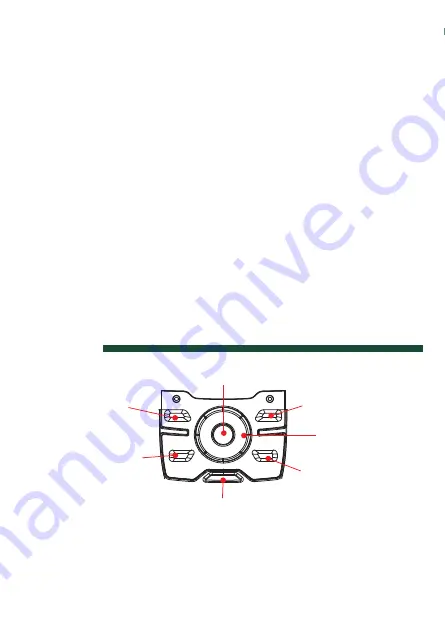
Keypad

Zoom Out

Zoom In

Page / Goto

Menu

8-way Cursor 

Contextual Menu

/Enter

Escape

The Page / Goto key is a dual function key.  Press for the 

Page function, press and hold for the Goto function.

B

C

D

I

J

Select baseline for the new 

waypoint:  

From your current location,

from a point on the map, or

from coordinates you enter.

To change the information in 

a field, tap on the field.

To save the waypoint, scroll 

down the page and tap ‘OK’.

C

M

Y

CM

MY

CY

CMY

K

631557-01 B.pdf   10/11/2007   1:34:33 PM

Summary of Contents for Triton 2000

Page 1: ...reference to the basic operation of the Magellan Triton Magellan Triton 2000 Reference Card5 2007 Magellan Navigation Inc All rights reserved The Magellan logo Magellan and Triton are trademarks of Magellan Navigation Inc Z1 Z 1 A B C D E F G ...

Page 2: ...tton Press to turn the receiver on press and hold to turn the receiver off E SD Card Slot The Magellan Triton can use SD cards to transfer files and load maps F Headphones Access for the connection of headphones with a 3 5mm audio jack G Touchscreen Stylus Storage for a stylus that can be used to access the touchscreen function of the Magellan Triton Keypad Zoom Out Zoom In Page Goto Menu 8 way Cu...

Page 3: ...ype selected Data Field 1 Customize to display data type selected Route indicator Destination icon Battery level indicator Present position cursor with direction of travel B C D E F G North indicator Navigational Fields access Satellite signal strength indicator H I J B C D I J ...

Page 4: ... satellites and signal strength Go outdoors and hold the receiver with the antenna top of the receiver up so the GPS receiver has a clear view of the sky This receiver may not be able to get satellite signals while indoors If you are not getting strong satellite signals go outside and follow the tips provided above Move away from large structures or overhanging trees that may interfere with satell...

Page 5: ...lect baseline for the new waypoint From your current location from a point on the map or from coordinates you enter To change the information in a field tap on the field To save the waypoint scroll down the page and tap OK ...

Page 6: ...Creating a GOTO Route 631557 01 B From the Map screen press the Contextual Menu button Map Screen Goto route is indicated by the orange line from your present position to the waypoint selected ...

Page 7: ...arks etc from the basemap or from optional installed maps Waypoint Select a waypoint to set a one leg route to Trail Follow a previously saved trail Geocache Select a stored cache waypoint to set a one leg route to Route Choose a saved route to follow ...

Page 8: ... from the current location a point on the map or enter coordinates Trail Saving current breadcrumb track as a Trail Geocache Create a cache waypoint from the current location a point on the map or enter coordinates Route Create a a multi leg route that can be saved ...

Page 9: ...nting fishing times and sunrise sunset information Tracks Select from Review History Vertical Profile Save Tracks Erase Tracks or track Options Music Photos View stored photos music and recordings Profiles View hiking marine and geocaching profiles Settings View navigation settings memory connectivity about and perform diagnotics ...

Page 10: ...tic or True Coordinate System Primary and Secondary Select from Lat Lon or other coordinate systems listed Map Datum Primary and Secondary Select the map datum to be used by the Triton to match any map datum used on paper charts Re Initialize GPS Initialize GPS to your present position for quicker first fix ...

Reviews: