background image

53

Magellan SporTrak GPS Receiver

Reference

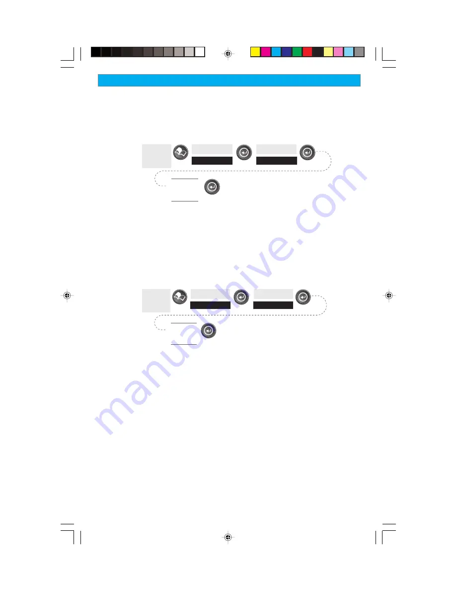
Selecting NMEA Message  — 

 Allows the selection of the NMEA message

that will be output from the SporTrak.  Choices are Off, V1.5 APA,
V1.5 XTE or V2.1 GSA.  Your choice will be dependent upon what
message the device you are connecting to needs to receive.

From

Any

Screen

Highlight

Setup

Highlight

NMEA

Select
NMEA

Message

Default: Off

Selecting the Baud Rate — 

Enables you to set the baud rate of the data

being sent out from the SporTrak’s output port.  The baud rate sent out
must match the baud rate that the receiving device is set for.  You can
choose from 1200 baud, 4800 baud, 9600 baud, 19200 baud, 57600
baud or 115200 baud.

From

Any

Screen

Highlight

Setup

Highlight

Baud Rate

Select

Baud

Rate

Default:  4800 Baud

Summary of Contents for SporTrak Series

Page 1: ...Mapping Mapping Receivers Receivers Receivers Receivers Receivers This manual covers both the SporTrak Map and the SporTrak Pro GPS receivers All of the functions described in this manual apply to bot...

Page 2: ...agellan cables and antennas the use of non Magellan cables and antennas may severely degrade performance or damage the receiver and will void the warranty LICENSE AGREEMENT Thales Navigation grants yo...

Page 3: ...obtain a Return Materials Authorization RMA number from Thales Navigation 800 707 7845 magellanrma thalesnavigation com prior to shipping If under warranty the purchaser must return the receiver or ac...

Page 4: ...OF THE NEGLIGENT USAGE OF THE PRODUCT IN NO EVENT WILL THALES NAVIGATION BE RESPONSIBLE FOR SUCH DAMAGES EVEN IF THALES NAVIGATION HAS BEEN ADVISED OF THE POSSIBILITY OF SUCH DAMAGES Some states do no...

Page 5: ...tion 5 Basic Operation SporTrak GPS Receiver 7 Turning Power On Off 8 Turning the Backlight On Off 8 Adjusting the Contrast 9 Getting a Position Fix 9 Navigational Screens 9 Map Screen 10 Compass Scre...

Page 6: ...Lines 23 Turning On Off Displayed POI s 23 Globally Turning Map Items On Off 24 Setting Up Map Data Fields 24 Turning Data Fields On Off 24 Selecting the Data Fields 25 Two Data Fields Description 25...

Page 7: ...ing Waypoints in the Database 38 Selecting Waypoints from the Nearest List 38 Selecting Waypoints from the Alphabetical List 38 Selecting Waypoints Nearest to the Cursor 39 Saving Present Position as...

Page 8: ...g the Elevation Mode 51 Selecting the Time Format 51 Selecting NAV Units 51 Selecting the North Reference 52 Setting the Backlight Timer 52 Turning the Beeper On Off 52 Selecting NMEA Message 53 Selec...

Page 9: ...ulator 59 Turning on the Simulator Auto Mode 59 Turning on the Simulator User Mode 59 Turning the Simulator Off 59 About Screen 60 Help Screen 60 Frequently Asked Questions General 61 Waypoints Databa...

Page 10: ...vi Magellan SporTrak GPS Receiver...

Page 11: ...ies Before you begin make sure that your package includes all of the items listed on the packing list Magellan is a trademark name for Thales Navigation This User Manual is divided into six chapters I...

Page 12: ...information about connecting your SporTrak to external devices accessories troubleshooting and specifications can be found in the Appendix Glossary A glossary is provided explaining some of the terms...

Page 13: ...ery compartment will come free from the SporTrak and you can slide it out Install two AA batteries observing the correct polarity Slide the battery compartment back into the SporTrak and tighten the r...

Page 14: ...ry to estimate what satellites are overhead and which ones it should be looking for Follow these instructions to initialize the SporTrak Turning the SporTrak On Press PWR The SporTrak turns on and dis...

Page 15: ...light your general region Press ENTER Use the Up Down arrows on the keypad to highlight your area Press ENTER The cursor appears in the time field waiting for you to input your local time Set your loc...

Page 16: ...alue up or down All the information that the SporTrak needs to speed up the process of computing its first fix has been entered and the Done button is highlighted To complete the initialization proces...

Page 17: ...ce to zoom one level press and hold to quickly move through the zoom levels OUT Zooms out the display of the Map screen Press once to zoom one level press and hold to quickly move through the zoom lev...

Page 18: ...Trak will turn the backlight off when there has been no button presses for 4 minutes Pressing any button will turn the backlight back on in this instance You can change the time delay for the backligh...

Page 19: ...use the SporTrak attains information it needs from satellites orbiting the earth the antenna needs to have a relatively unobstructed view of the sky This allows the SporTrak to choose from all satelli...

Page 20: ...y arrow on the keypad A crosshair appears that can be moved with the arrow keys To return to the Position Mode press ESC The cursor will disappear and the present position icon will appear centered on...

Page 21: ...sition as they come into view Above the road is a compass that displays your heading and above that are four customizable data fields Satellite Status Screen The Sat Status screen provides you with a...

Page 22: ...waypoint using the default name and icon You can later go back and edit any of the waypoint information through the Database Menu or you can change the information now following the guidelines below S...

Page 23: ...lect the character you wish to enter With the character highlighted press ENTER and the character is appended to the name you are entering and displayed in the field above the keys Note waypoint names...

Page 24: ...simply a route with a start point and a single destination point I am here and I want to go to there All that is required to create a GOTO route is having the destination waypoint saved in memory Thi...

Page 25: ...mple suppose your destination was to be Los Angeles Use the keypad to highlight the letter L and press ENTER Notice how the name is changed to the first city stored in the SporTrak s memory that begin...

Page 26: ...ata or Map screen For you the Map screen may have all the information you ll ever require Press NAV until the navigation screen you want is displayed If you selected the Map screen you will see your p...

Page 27: ...is waypoint Home would be a good choice When you have finished inputting a name and you ve highlighted DONE and pressed ENTER you will be back at the Map screen Notice there is now an icon displayed f...

Page 28: ...seconds to press ENTER accepting the warning or the SporTrak will shut off Turn the SporTrak Off Shuts down the SporTrak Press ESC to abort before 5 seconds has elapsed During the 5 second countdown...

Page 29: ...Screen Position Screen Road Screen Sat Status Screen Navigation Screen Sequence Returning to Last Viewed NAV Screen Pressing the NAV button returns the SporTrak to the last NAV Screen viewed Note if...

Page 30: ...anged with the IN and OUT buttons Track History Track History Track History Track History Track History Dotted line on the map displays the history of where you have travelled since the last time you...

Page 31: ...n Block Map Scale Indicator Cursor Icon Cursor Icon Cursor Icon Cursor Icon Cursor Icon Cursor Icon The Cursor Icon pinpoints the location you have selected by using the arrow keys Map Scale Indicator...

Page 32: ...el to view more detail The default is Medium From the MAP Screen Highlight Map Setup Use arrows to highlight the Detail field Use arrows to select the desired Map Detail level Map Screen Legend Presen...

Page 33: ...p screen represented by a dashed line This function allows you to turn off or on these lines Default is On From the MAP Screen Highlight Map Setup Use L R arrows to select Display tab Use U D arrows t...

Page 34: ...ursor mode press the ESC key and the display will snap back to the Position Mode with the arrow icon displaying your present postion If you are not clear on which mode you are in the simpliest way to...

Page 35: ...e Note If you have selected Hide Map Info this option will not be available in the menu Also you must have the Two Data Fields displayed on the Map screen to be able to customize them Press ESC when y...

Page 36: ...rain directly ahead of you graphically It is computed from your present position and extends in a straight line to the top of your display This provides you with instantaneous information on what terr...

Page 37: ...t the top of the screen Selecting Primary Usage The SporTrak can be set to either Land or Marine Usage When in Land default the map displays land areas in white and water areas as dark gray For marine...

Page 38: ...with minimal track points stored Auto Detailed performs exactly the same as Auto but has the base rate of track points saved increased This allows a more detailed track then Auto to be taken while at...

Page 39: ...e Description Available only with map data uploaded from Magellan MapSend Topo for the United States If you have at least one route stored in memory you can view the vertical profile for the route Aft...

Page 40: ...played can be selected from 13 different options Customizing is accessed through the MENU button Some of the data displayed requires you to be moving to be computed invalid data is indicated by dashes...

Page 41: ...Destination Name Destination Name Destination Name Destination Name When you are navigating on a GOTO or multileg route the name of the destination is placed here For multileg routes the name display...

Page 42: ...basic position time and satellite information all on one screen In addition current navigation information is shown on the bottom half of the screen Selecting the Position Screen Allows you to toggle...

Page 43: ...e GPS receiver portion of the SporTrak Data Fields Data Fields Data Fields Data Fields Data Fields Customizable data fields The data displayed can be selected from 13 different options Customizing is...

Page 44: ...eded for position fix are being tracked and position is being computed Averaging SporTrak is computing fixes speed is near 0 0 so position is being averaged EPE xxft Estimated Position Error in feet S...

Page 45: ...do a GOTO to the waypoint you just created You can also project waypoints from any stored waypoint or POI by highlighting the From field and pressing ENTER This will take you to the SporTrak s databas...

Page 46: ...n in a graphical format At the top of the display are four customizable data fields Immediately below them is a compass that will provide you with your heading Following the compass is a graphical rep...

Page 47: ...are shown with solid bars The height of the bar indicates the relative signal strength Power Source Power Source Power Source Power Source Power Source Indicates the source of power being used POWER...

Page 48: ...of waypoints that you can choose from The information at the bottom of the screen indicates the bearing and distance to the highlighted waypoint from your present position Use up down arrows to highli...

Page 49: ...de Saving Present Position as a Waypoint Creates and stores your present position into the memory of the SporTrak Stored waypoints can be used in GOTO and route creation While saving the waypoint you...

Page 50: ...Note Note To modify the icon name or message use the Up Down arrows to highlight the field you wish to change and press ENTER You are then placed into the Edit Mode Deleting a User Waypoint Deletes a...

Page 51: ...highlight View button Note If the waypoint is used in a route you will get a warning that it is in a route after selecting it from the list This is because the screen that you access the view button...

Page 52: ...ows to view address range Highlight Mark or View Mark If you select Mark and press ENTER the Edit Waypoint screen is displayed You can now change any of the attributes for this waypoint Highlight Save...

Page 53: ...r all of the waypoints in the category in alphabetical order Alphabetical Creating a Backtrack Route Creates a route using track information stored in the SporTrak to retrace your steps A good example...

Page 54: ...e your present position B they are always in memory and if activated they remain activated even when you turn the SporTrak off and then back on and C they can be saved and used over and over again Fro...

Page 55: ...steps to activate it From Any Screen Highlight Routes Select Route Highlight Activate or Deactivate Note If the route is active the SporTrak will automatically display Deactivate Route in the menu an...

Page 56: ...sting leg thereby making two legs where there used to be one Select route to be edited See Instructions for Viewing a Route Highlight Insert Select Database Highlight destination waypoint for leg that...

Page 57: ...ase Highlight next available leg Indicated by dashes Select Waypoint Appending a Newly Created Waypoint to a Route Allows a newly created waypoint to be appended to any route in memory Create a Waypoi...

Page 58: ...n Provides you with a graphical representation of the route selected on the Map screen From Any Screen Highlight Routes Select Route Highlight Map View Creating a Route Using Track History This enable...

Page 59: ...alize Highlight Area Input Time Input Date Turning NAV Screens On Off Allows you to turn off or on any of the navigation screens you choose From Any Screen Highlight Setup Sat Status On Off Highlight...

Page 60: ...stem The coordinate system you select may require additional information Select Primary or Secondary Select Coordinate System Default Primary Lat Lon DEG MIN MMM Secondary UTM Selecting a Map Datum Al...

Page 61: ...t 3D Selecting the Time Format Enables you to choose from three different time formats Local 24 Hr military time Local AM PM or UTC From Any Screen Highlight Setup Highlight Time Format Select Format...

Page 62: ...me interval that will be used to turn off the display backlight when not in use Times available are 30 seconds 1 Minute 2 Minutes 4 Minutes 10 Minutes or Timer Off From Any Screen Highlight Setup High...

Page 63: ...needs to receive From Any Screen Highlight Setup Highlight NMEA Select NMEA Message Default Off Selecting the Baud Rate Enables you to set the baud rate of the data being sent out from the SporTrak s...

Page 64: ...he appropriate daylight savings time United States or European Union only will automatically be set by the SporTrak during startup when you use the SporTrak for the first time Power Off Timer Conservi...

Page 65: ...Routes This will clear all waypoints and routes from the SporTrak s memory Clearing all Routes This clears all routes from the SporTrak s memory Resetting SporTrak to Factory Defaults Allows you to r...

Page 66: ...MAP screen is displayed and press MENU Select the seventh item in the list and press ENTER Press the Up Arrow once and press ENTER You are back at the Language Select screen Accessing the Sun Moon Scr...

Page 67: ...for fishing or hunting for the position you choose from your User waypoints From Any Screen Highlight Fish Hunt Changing the Fish Hunt Date Allows you to change the date for the fishing hunting infor...

Page 68: ...Anchor Alarm The anchor alarm will sound when you have drifted from your anchor point at a distance you set An example of its use would be as you set anchor you turn on the anchor alarm to beep at a...

Page 69: ...onfirm Clearing of Track Turning on the Simulator User Mode This turns the simulator on and uses a heading and speed rate that you define From Any Screen Highlight Setup Highlight User Highlight Simul...

Page 70: ...umber of and total memory size of detailed maps you may have installed using MapSend Streets and how much free memory is available From Any Screen Highlight About Help Screen You can view help tips fo...

Page 71: ...to be the same as any map or chart you may be using What is 2D vs 3D The difference is primarily how many satellites are used to compute the position fix and how elevation is computed In 2D two dimens...

Page 72: ...minutes in severe conditions So where does this reference come from Under normal operating conditions the last position fix computed before the SporTrak was turned off is stored into memory and will...

Page 73: ...porTrak will use to retrace your steps When you create a backtrack route the SporTrak converts these hidden waypoints into User Waypoints How do I know which route is active Access the route menu by p...

Page 74: ...d on the internet by Peter Bennett at vancouver webpages com peter nmeafaq txt My GPS is not communicating with my computer What can I do Check your baud rate and check the baud rate that your softwar...

Page 75: ...fe seems shorter than it should be 1 Make sure that you are using two AA alkaline batteries 2 Shorter life span of the batteries can be due to excessive use of the backlight Turn the backlight off whe...

Page 76: ...t Restaurant Rock Scuba RV Service Shooting Sight Seeing Small City Sounding Sports Arena Tourist Info Truck Service Winery Wreck Zoo Default Box House Aerial Airport Amusement ATM Auto Repair Boating...

Page 77: ...ber ship the receiver by Parcel Post or UPS Include a description of the problem your name address a copy of your sales receipt and print clearly on the outside of the package the RMA number assigned...

Page 78: ...0 1 knot RMS steady state Limits Speed 951 mph Altitude 17 500 meters Physical Size 5 6 x 2 2 x 1 15 h x w x d 14 2 cm x 5 6 cm x 2 9 cm Weight 6 ounces 170 grams with 2 AA batteries installed Display...

Page 79: ...e Lighter Adapter Connects your receiver to your PC for data transfer and to a cigarette lighter for external power External Power Cable with Cigarette Lighter Adapter Allows you to connect the receiv...

Page 80: ...cities Enables you to load street maps for any region in the United States Canada or Europe into the SporTrak Allows you to cut any rectangular map region you choose to load into the receiver Maps are...

Page 81: ...r The instructions given below apply to all cables unless otherwise stated Connecting directly to the SporTrak Using the captive screw that is attached to the plug tighten into the back of the receive...

Page 82: ...r external power source The input voltage range for external power is 9 18 VDC Caution Do not bypass the power supply box or you will damage your unit and void the warranty Power Supply Box Cut Here C...

Page 83: ...accuracy improvements to around 3 meters You can expect to see this level of accuracy for 95 of the time that you are receiving WAAS signals What are some of the problems with WAAS The signal coverag...

Page 84: ...o return to the course while proceeding towards the destination It is a compromise course bearing that projects from your current position to a point on the courseline midway between a point perpendic...

Page 85: ...rom waypoint A to waypoint B to waypoint C to waypoint D has three legs with the first being from waypoint A to waypoint B Longitude The angular distance east or west of the prime meridian Greenwich M...

Page 86: ...st large and intermediate scale land topographic charts and maps VMG Velocity Made Good The component of the velocity that is in the direction of the destination WPT Waypoint A location saved in the r...

Reviews: