36
ENGLISH
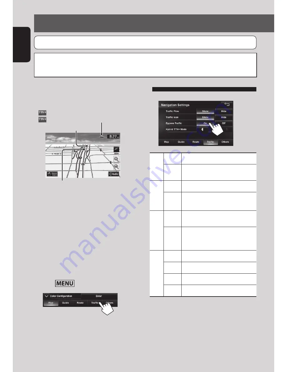
Traffic information on the map
Congestion
(green): When receiving information from HD radio
(red): When receiving information from iHeartRadio
Traffic icon (
☞
page 37)
• Traffic icons are displayed on the map when its
scale is between 80 ft (25 m) and 0.6 mi (1 km) with
<
Traffic Icon
> setting activated. (
☞
table on the
right)
• Congestion lines are displayed when the scale is
between 80 ft (25 m) and 2.5 mi (4 km).
How traffic information is reflected in
navigation
The traffic information is reflected in navigation
differently according to <
Traffic
> setting.
1
Press
- <Settings> - <Navigation>.
2
Using information service
(Only for KW-NT800HDT)
3
Traffic Flow
Show
Congestion lines appear on the map.
Hide
Congestion lines do not appear on
the map.
Traffic Icon
Show
Traffic icons are displayed on the map.
Hide
Traffic icons are not displayed on the
map.
Bypass Traffic
On
Recalcurate the route when you
approach a traffic event.
Off
The System does not take traffic
information into account for the
route.
Hybrid TTN
+
Mode
(from iHeart Link App) *
All
Receive news and traffic information.
News
Receive only news information.
Traffic
Receive only traffic information.
Off
No information is received.
*
Hybrid TTN
+
Mode receives news and real-time traffic
information from the iHeart Link app, when you are
out of HD radio coverage.
*
For details on iHeart Link App,
☞
page 71
*
When receiving traffic information, launch iHeart Link
App and connect your iPhone/iPod to the system in
advance.
Using the traffic information service
This function is available on KW-NT800HDT only, not equipped with on KW-NT700.
You can use the information services provided by Total Traffic HD NETWORK service (from HD Radio) and Total Traffic
CONNECT service (from iHeart Link App).
JVC cannot assume responsibility for the completeness or accuracy of the information.
EN_KW-NT800HDT_NT700[J].indb 36
1/27/2012 4:40:02 PM


