background image

10

GTN 625/635/650 Cockpit Reference Guide

190-01004-04  Rev. N

Map

Creating (or Editing) a Flight Plan in Pan Mode


NOTE:  

It is not possible to graphically add an intermediate waypoint between 

the current position and a Direct-To waypoint unless that waypoint is in the 
flight plan. Garmin recommends deleting any flight plan prior to graphically 
editing a Direct-To waypoint.


NOTE:  

When graphically editing the active flight plan leg, the active leg  

course and TO waypoint will be added to the flight plan as a Direct-To.

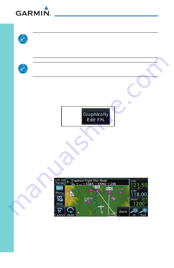
While in Pan Mode, touch the 

Graphically Edit FPL

 key to add/remove 

waypoints and/or alter a course line in an existing flight plan. You can also 
enter or edit an existing flight plan by touching the Flight Plan key on the 
home page. See the “Flight Plan” section of this guide.

G


On the Map page, enter Pan Mode by touching the screen. Touch the 

Graphically Edit FPL 

key.  Touch any waypoint that you want to be part of 

your flight plan. You also can touch and drag a flight plan line to a waypoint. 
Should you make an error, touch the 

Undo

 key. The 

Undo

 key will reverse 

up to the last nine consecutive edits. When finished, touch the 

Done

 key to 

save your changes. Touch 

Cancel

 to leave the screen without making any 

changes to the flight plan.

Undo Key

Touch to leave 

the page without 

changes to the 

flight plan.

Touch to confirm the 

entries into the flight plan.

Flight Plan on Map Page

Summary of Contents for GTN 625

Page 1: ...Map Traffic Terrain Weather Procedures Default NAV Waypoint Info Nearest Utilities Services GTN 625 635 650 Cockpit Reference Guide Flight Plan System...

Page 2: ...ecognize that providing monitoring and or self test capability for all conceivable system failures is not practical Although unlikely it may be possible for erroneous operation to occur without a faul...

Page 3: ...ion the weather information shown by the data link weather product may be significantly older than the indicated weather product age WARNING Never use datalinked weather to attempt to penetrate a thun...

Page 4: ...loth and an eyeglass lens cleaner that is specified as safe for anti reflective coatings CAUTION TFRs provided by datalink weather sources i e FIS B and SiriusXM are only advisory and do not replace a...

Page 5: ...n related to the use of databases in the National Airspace System Garmin equipment will only recognize and use databases that are obtained from Garmin or Jeppesen Databases obtained from Garmin or Jep...

Page 6: ...lated to database information These discrepancies could come in the form of an incorrect procedure incorrectly identified terrain obstacles and fixes or any other displayed item used for navigation or...

Page 7: ...3 10 2013 08 2014 07 2015 01 2016 09 2016 08 2017 07 2018 04 2019 Initial Release Updated message list Updated part number back cover only Added v3 00 functionality Added v4 00 functionality Added v5...

Page 8: ...ds 8 Pan Mode 9 User Waypoints 9 Creating or Editing a Flight Plan in Pan Mode 10 Traffic 11 Traffic System Status Annunciations 12 TCAS 14 TCAD 15 ADS B Traffic 16 Terrain 18 TAWS 18 HTAWS 19 Weather...

Page 9: ...ice 46 Connext Operation with Flight Stream 210 and 510 47 Connext Setup Other Bluetooth Devices 48 Symbols 49 Map Symbols 49 SafeTaxi Symbols 50 Traffic Symbols 50 Terrain Obstacle Symbols 52 HTAWS O...

Page 10: ...x GTN 625 635 650 Cockpit Reference Guide 190 01004 04 Rev N This page intentionally left blank...

Page 11: ...acard Home Page Annunciations Function Keys Locking Screw Message Annunciation And Key Xpdr Panel Controls opt Volume Squelch On Off and Nav ID On Off GTN 650 Front Panel Main Page Direct To Key Press...

Page 12: ...Plan waypoint 3 Touch Activate or press the small right knob Direct To a Nearest Airport OR 1 Press Direct To 2 Touch the NRST APT tab and then the desired airport from the Nearest Airport list Touch...

Page 13: ...d by touching Cyan colored keys represent fields that can be modified white colored keys represent keys that change the state of operation for the related feature The COM or NAV frequency is changed b...

Page 14: ...COM after 30 seconds of inactivity 2 Turn the large right knob to the desired MHz value 3 Turn the small right knob to the desired kHz value 4 Press the small right knob to confirm entry Frequency Fl...

Page 15: ...C Transponder Standby Touch to place transponder in Standby mode It is still powered but will not transmit information STBY displays in the squawk code field Ground Touch to place transponder in Grou...

Page 16: ...on ground the TCAS may remain in a different mode Special Squawk Codes The selected squawk code will always be in use As you change a squawk code the original code will be sent until you are finished...

Page 17: ...hat are displayed on the map page Touch to select the fields that are displayed in the four corners on the Map Touch to restore the user fields to Garmin factory defaults Touch to customize how the ma...

Page 18: ...vigation parameters To exit without changes to the Map page touch Cancel G G G Touch to select data field TRK currently shown Touch to select data field DIS currently shown Touch to cancel any changes...

Page 19: ...en touch the information key to display any available information related to that symbol Touch the Next key to cycle to other waypoints close to the cursor User Waypoints Touch any location on the map...

Page 20: ...d or alter a course line in an existing flight plan You can also enter or edit an existing flight plan by touching the Flight Plan key on the home page See the Flight Plan section of this guide G On t...

Page 21: ...to the GTN 625 635 650 Pilot s Guide P N 190 01004 03 for more information Touch to select traffic mode Selections are Operate and Standby Touch to activate testing mode Touch to select the altitude f...

Page 22: ...der has failed Unavailable TIS is unavailable or out of range TIS Traffic Status Annunciations Traffic Status Banner Annunciation Description Traffic Coast 9 SEC The displayed data is not current 6 to...

Page 23: ...nce in NM altitude separation in hundreds of feet and altitude trend arrow climbing descending TA 6 0 03 System cannot determine bearing of Traffic Advisory Annunciation indicates distance in NM altit...

Page 24: ...onfigured traffic device Motion Vector Touch to set the type of motion vector Selections Absolute Relative Off Vector Duration Touch to set the time used to calculate the motion vector length Selectio...

Page 25: ...ontrol Menu allows control over the settings for the TCAD Traffic display TCAD Control Menu Touch to set traffic audio volume Touch to activate operation Touch to set local baro Touch to select approa...

Page 26: ...nd Altitude Filter Touch to view Traffic Menu Selected Vector Motion and Duration Touch for next target Range Rings Range Ring Radius Proximity Advisory 1 200 ft Above and Climbing Traffic Direction o...

Page 27: ...ravel in the amount of time selected in Vector Duration NOTE Absolute motion vectors are colored either white or cyan Relative motion vectors are always green The annunciation on the bottom of the tra...

Page 28: ...bols section G Heading Annunciation Aircraft GSL value GPS derived Terrain Overlay Active Flight Plan Leg Terrain Type Terrain Legend Obstacles Terrain Page TAWS G G Touch to display the active flight...

Page 29: ...WS Touch to display the active flight plan Touch to display terrain as a 360 ring or a 120 arc Touch to display the terrain legend Touch to toggle Reduce Protection RP mode on and off Touch to test HT...

Page 30: ...r to the GTN 625 635 650 Pilot s Guide P N 190 01004 03 for more information G SiriusXM Weather Optional G G G Touch to select the weather overlay map orientation Touch NEXRAD to select Off Composite...

Page 31: ...play of turbulence data Wind Temp Aloft Touch to toggle the display of wind and temperature data Lightning Touch to toggle the display of lightning data METAR Touch to toggle the display of METARs PIR...

Page 32: ...190 01004 04 Rev N Weather Stormscope Weather Optional NOTE Refer to the WX 500 Pilot s Guide for a detailed description of the WX 500 Stormscope G G G Displays Stormscope as 360 ring or 120 arc Touc...

Page 33: ...h to toggle the display of METARs PIREP Touch to toggle the display of PIREPs Winds Aloft and SIGMETs AIRMETs Winds Aloft Touch to toggle the display of PIREPs Winds Aloft and SIGMETs AIRMETs SIGMET A...

Page 34: ...fault NAV DEFAULT NAV G Data Fields Default Navigation Page G G Touch to restore the default user fields Touch to configure the user fields Default Navigation Menu Data field selections are the same a...

Page 35: ...e touch Add Waypoint to display an alphanumeric keypad Type in the airport identifier and touch Enter If unknown touch the Find key to search To exit without making changes to the flight plan touch th...

Page 36: ...ust altitude temperature compensation Touch to view the VNAV Profile page Touch to reverse currently loaded flight plan Touch to edit fields shown on flight plan page Touch to delete current flight pl...

Page 37: ...Rev N GTN 625 635 650 Cockpit Reference Guide Active Flight Plan En route Vertical Navigation VNAV G G G Touch to toggle VNAV Touch to select target vertical speed Touch to select flight path angle VN...

Page 38: ...ht Plan VNAV Options G G Touch to offset the altitude constraint Touch to select the constraint type Touch to revert to the published constraint Touch to remove the altitude constraint Touch to naviga...

Page 39: ...ions menu is displayed G Waypoint Options Menu Load Airway Touch entry waypoint to select available airways and exit waypoints Load Touch to load selected airway into flight plan Cancel Touch to exit...

Page 40: ...Procedures PROCEDURES G Departures Arrivals and Approaches On the Procedures PROC page select approach arrival and departure procedures Touch to activate available approaches Touch to enter departure...

Page 41: ...the MAP is reached a pop up will appear Pop Up Upon Reaching the MAP 2 Touch the Remain Suspended key to continue with sequencing suspended or touch Activate GPS Missed Approach for guidance to the M...

Page 42: ...to display the bearing distance and frequency of the nearest ARTCC Touch to display the bearing and distance of the nearest airspace Touch to display the bearing distance and frequency of the nearest...

Page 43: ...Touch to display distance bearing and reference waypoint information for created waypoints Touch to display map of the airport procedures runways frequencies weather and any NOTAMs Touch to display di...

Page 44: ...e 2 Enter the desired name identifier and position or reference another waypoint by radial and distance The identifier can be a maximum of 6 characters and the comment can be a maximum of 24 character...

Page 45: ...N GTN 625 635 650 Cockpit Reference Guide Services SERVICES G Touch to send an SMS text Touch to view your contacts Touch to listen to music Touch to activate phone Touch to review position report set...

Page 46: ...uch the Phone key to display the phone page 2 Touch the Phone Number key to display a phone keypad 3 Touch the Contacts key to enter a saved phone number or enter the phone number using the keypad Tou...

Page 47: ...y to display a numeric keypad 2 Touch numbers of the channel number 3 Touch Enter to accept channel Adding Channels to Presets 1 Touch the Presets key The choices are XM1 XM2 and XM3 2 Touch the Chann...

Page 48: ...s 2 to 60 minutes Touch to send position report Position Reports Page Position Reporting 1 Touch the Position Reports key 2 Touch the Automatic Reporting key to enable reporting of position automatica...

Page 49: ...ail Address key to enter the contact email address optional 5 Touch the Save Contact key to save entry to list The list can hold 250 entries Editing a Contact 1 In the contact list touch the contact t...

Page 50: ...true airspeed and wind Touch to see the integrity of GPS satellite coverage at a particular waypoint at a particular time Touch to view trip information about the currently loaded flight plan Touch to...

Page 51: ...ow At the present location a vertical speed rate of 404 feet per minute is required to reach the target There are no menu options for the VCALC Profile page G G Touch to set target altitude Touch to s...

Page 52: ...CDI Date Time Nearest Airport Criteria and COM Channel spacing Touch to customize the volume of the response sound when touching the screen Touch to display serial number system ID version informatio...

Page 53: ...e NAV frequencies Date Time convention Nearest airport criteria Units NAV angle Fuel and Temperature Favorite COM frequencies CDI Scale setting ILS CDI Capture setting This data is crossfilled only if...

Page 54: ...ally transfer user waypoints GTN GNS Crossfill Selection 2 Touch Auto GNS Crossfill to enable Crossfill and send the Active Flight Plans and the active Direct To course to the GNS unit 3 Touch the Tra...

Page 55: ...is active Connext Setup Flight Stream 210 and 510 The GTN interfaces with the Flight Stream 210 Bluetooth transceiver and Flight Stream 510 wireless datacard Using a Flight Stream and the GTN flight...

Page 56: ...manage paired devices Bluetooth Setup for Flight Stream 210 Pairing a Device New devices can only be paired with the Flight Stream when it is in Pairing Mode The Flight Stream will be in pairing mode...

Page 57: ...ht plan importing phone SMS and Database transfers setup Flight Stream Bluetooth and Wi Fi and manage paired Bluetooth devices On the GTN s Paired Devices page the device status indicates if the porta...

Page 58: ...ed the existing connection must be ended by removing the portable device pairing or by disconnecting or disabling Bluetooth on the portable device Removing a device from this page by pressing Remove w...

Page 59: ...shown Airport with hard surface runway s Non Serviced Primary runway shown Airport with soft surface runway s only Serviced Airport with soft surface runway s only Non Serviced Unknown Airport Restric...

Page 60: ...ols TIS Symbol Description Non Threat Traffic Traffic Advisory TA Traffic Advisory Off Scale TAS Symbol Description Non Threat Traffic intruder is beyond 5 NM and greater than 1 200 ft vertical separa...

Page 61: ...sory Off Scale ADS B Symbol Description Basic Non Directional Traffic Basic Directional Traffic Basic Off scale Selected Traffic Proximate Non Directional Traffic Proximate Directional Traffic Proxima...

Page 62: ...AGL Lighted Obstacle Height is less than 1 000 ft AGL Unlighted Obstacle Height is greater than 1 000 ft AGL Lighted Obstacle Height is greater than 1 000 ft AGL Obstacle Altitude Color Correlation T...

Page 63: ...tude Terrain is between 0 ft and 250 ft below the aircraft altitude Terrain is more than 250 ft above the aircraft altitude Terrain is between 250 ft and 0 ft above the aircraft altitude Aircraft Alti...

Page 64: ...ed and Not Available Indicator software v5 12 and later Wire Obstacles Enabled and Available Indicator software v5 12 and later Wire Obstacles Enabled and Not Available Indicator software v5 12 and la...

Page 65: ...nship Low Wing Prop High Wing Prop Kit Plane Single Engine Jet Twin Engine Prop Single Engine Jet Business Jet 2 Blade Rotorcraft 3 Blade Rotorcraft 4 Blade Rotorcraft High Visibility Arrow Basic Airc...

Page 66: ...635 650 Cockpit Reference Guide 190 01004 04 Rev N Symbols Symbol Description MOA Class B Airspace Class C Airspace Class D Airspace User Waypoint Stormscope Symbols Symbol Time Since Strike Seconds 6...

Page 67: ...aft is predicted to enter an airspace type within 10 minutes for which alerts are configured No action is necessary message is informational only AIRSPACE ALERT Airspace within 2 nm and entry in less...

Page 68: ...e APR Output before selecting APR on autopilot The GTN is configured for KAP140 KFC225 autopilot and approach guidance is now available Press the Enable APR Output key on the GTN this will cause the a...

Page 69: ...n temperature and increase cabin airflow especially near the GTN Check aircraft voltage and reduce electrical load as necessary Contact dealer for service if this message persists COM RADIO COM radio...

Page 70: ...ING FAN The cooling fan has failed The GTN cooling fan is powered but it is not turning at the desired RPM Decrease cabin temperature and increase cabin airflow especially near the GTN to prevent dama...

Page 71: ...dures Modify stored flight plans and procedures as necessary to include the current procedures by re loading those procedures to the stored flight plan routes DATABASE Terrain display unavailable for...

Page 72: ...s database on the external datacard DATACARD ERROR SD card is invalid or failed External datacard has an error and the unit is not able to read the databases ChartView FlightCharts and Terrain databas...

Page 73: ...sage due to a failure with the GDL 88 system or antenna s Contact dealer for service DATALINK GDL 88 ADS B fault The GDL 88 has detected a fault with one of the GDL 88 UAT 1090 antennas Contact dealer...

Page 74: ...nternal fault Contact dealer for service DATALINK GSR 56 data services inoperative registration required The GSR 56 is not registered GSR Weather Position Reporting and Phone Services will be unavaila...

Page 75: ...rative or connection to GTN lost The GTN is configured to receive radio altitude information but is not receiving it from any source 50 foot aural annunciation is unavailable for HTAWS installations C...

Page 76: ...Contact dealer for service FPL WAYPOINT LOCKED Stored flight plan waypoint is not in current navigation database A stored flight plan waypoint is no longer in the current navigation database Verify st...

Page 77: ...GNS CROSSFILL GTN user waypoint s replaced with GNS user waypoints A user waypoint from the GNS replaced one or more existing waypoints on the GTN Ensure that the waypoints on the GNS have unique nam...

Page 78: ...indicates that its clock battery is low Almanac data may have been lost The unit will function normally but may take a longer than normal period to acquire a GPS position Contact dealer for service GP...

Page 79: ...user Contact dealer for service INTERNAL SD CARD REMOVED GTN needs service Internal SD card was removed or failed This card is not accessible by the user Contact dealer for service KEY STUCK Direct To...

Page 80: ...OSS OF INTEGRITY LOI Verify GPS position with other navigation equipment Antenna may be shaded from satellites The GPS module has reported a loss of integrity Make sure the aircraft is clear of hangar...

Page 81: ...formational only NAV ANGLE NAV Angles are referenced to True North T NAV angle is set to True No action is necessary message is informational only NON WGS84 WAYPOINT See CRG Location may be different...

Page 82: ...This input will now be ignored This input is not available in all installations Verify the ALRT ACK key switch is not stuck Contact dealer for service if this message persists REMOTE KEY STUCK COM pus...

Page 83: ...TE KEY STUCK COM remote transfer key is stuck The remote COM transfer COM RMT XFR key switch has been in pressed position for at least 30 seconds This input will now be ignored This input is not avail...

Page 84: ...w be ignored This input is not available in all installations Verify the CDI SRC SEL key switch is not stuck Contact dealer for service if this message persists REMOTE KEY STUCK Remote go around key i...

Page 85: ...iscrete input has been in pressed position for at least 30 seconds This input will now be ignored This input is not available in all installations Verify the TAWS INHIBIT key switch is not stuck Conta...

Page 86: ...ormScope reports that it has an invalid heading source GTN StormScope data is correct and may be used Contact dealer for service STORMSCOPE StormScope is inoperative or connection to GTN is lost The G...

Page 87: ...has a low battery The GDL 88 is reporting that the external traffic system has a low battery Contact dealer for service TRAFFIC Traffic device battery low Traffic device user config settings not saved...

Page 88: ...iew of the sky Contact dealer for service TRANSPONDER 1 OR 2 ADS B Out system fault Pressure altitude source inoperative or connection lost The transponder has lost communication with the pressure alt...

Page 89: ...limits Decrease temperature and increase airflow near the transponder if possible Monitor aircraft electrical indications Contact dealer for service if this message persists TRANSPONDER 1 OR 2 Transp...

Page 90: ...int catalog to remove unneeded user waypoints USER WAYPOINT IMPORT User waypoints imported successfully existing waypoints reused User waypoints imported and existing waypoints are used instead of cre...

Page 91: ...oint The current altitude constraint cannot be reached based on the current ground speed and vertical speed Adjust the aircraft attitude as appropriate to attempt to intercept the vertical path VNAV U...

Page 92: ...t dealer for service WAYPOINT Arriving at wpt name User has configured the arrival alarm and is within the specified distance No action is necessary message is informational only Note 1 There are seve...

Page 93: ...gloves and gloves designed specifically for use with capacitive touchscreen devices are often found to be acceptable To improve touchscreen sensitivity while wearing gloves use the pad of your finger...

Page 94: ...without a glove the pilot may use the glove in flight Procedure Pilot Glove Description GTN circle one 6XX or 7XX Tests Required for Glove Qualification Task Operation With Glove circle one Starting f...

Page 95: ...s up and down using the arrow keys Same Worse Back Same Worse GTN 635 650 750 only Select the COM STBY frequency field Same Worse Type a valid frequency Same Worse Enter Same Worse Select the active C...

Page 96: ...n the page drag the waypoint list up and down Same Worse With one finger tap and swipe the list up or down Same Worse Back Same Worse Open the Map page Same Worse Graphically Edit FPL Same Worse Tap a...

Page 97: ...ice command is uninterpretable verify the system is performing the intended action or displaying the desired data If the system does not recognize a command use the touchscreen to execute the function...

Page 98: ...how map page is spoken and the traffic page displays Show map page is spoken and a negative tone sounds Qualification Procedure Speak the unbold phrase if the voice command in this procedure is not ap...

Page 99: ...equency PAGE TOGGLE COM 2 or SAY Distance SHOW Map PAGE ZOOM OUT SAY Distance to Destination SHOW Flight Timers PAGE SELECT COM 2 or SAY ETA at Destination SAY Active Waypoint CREATE Waypoint Here TUN...

Page 100: ...90 GTN 625 635 650 Cockpit Reference Guide 190 01004 04 Rev N This page intentionally left blank...

Page 101: ......

Page 102: ...icted Substances document P N 001 00211 00 Garmin FliteCharts and SafeTaxi are registered trademarks of Garmin Ltd or its subsidiaries Garmin SVT is a trademark of Garmin Ltd or its subsidiaries These...

Reviews: