background image


GPSMAP 78 Series Owner’s Manual

Customizing Your Device 
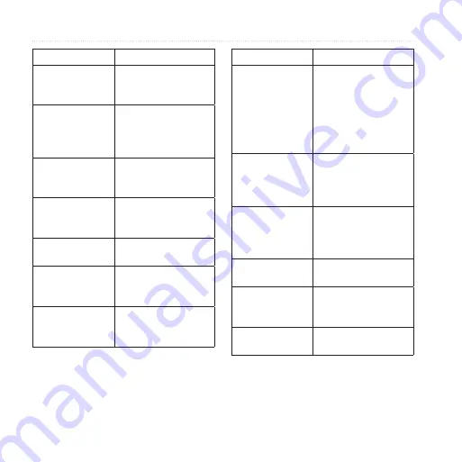
Data Field

Description

Time to 

Destination

The estimated time 

needed to reach your 

final destination.

Time to Next

The estimated time 

needed until you reach 

the next waypoint on 

the route.

To Course

The direction in which 

you must move to 

return to the route.

Trip Odometer

A running tally of the 

distance traveled since 

the last reset.

Trip Time - Moving A running tally of time 

since the last reset.

Trip Time 

- Stopped

The time spent not 

moving since the last 

reset.

Trip Time - Total

A running tally of 

distance traveled since 

the last reset.

Data Field

Description

Turn

The angle of difference 

(in degrees) between 

the bearing to your 

destination and your 

current course. L 

means turn left. R 

means turn right.

Velocity Made 

Good

The speed at which 

you are closing on a 

destination along a 

route.

Vert. Speed to 

Dest.

The measurement of 

your rate of ascent 

or descent to a 

predetermined altitude.

Vertical Speed

Your rate of altitude 

gain or loss over time.

Waypoint at Dest. The last point on 

a route to your 

destination.

Waypoint at Next The next point on your 

route.

Summary of Contents for GPSMAP 78 series

Page 1: ...GPSMAP 78 series owner s manual for use with the GPSMAP 78 GPSMAP 78S and GPSMAP 78Sc ...

Page 2: ...b site www garmin com for current updates and supplemental information concerning the use and operation of this and other Garmin products Garmin BlueChart g2 Vision City Navigator and GPSMAP are trademarks of Garmin Ltd or its subsidiaries registered in the USA and other countries HomePort BaseCamp ANT and ANT are trademarks of Garmin Ltd or its subsidiaries These trademarks may not be used withou...

Page 3: ...s 7 Additional Maps 9 Tracks 10 About Tracks 10 Navigating a Saved Track 11 Using the Main Pages 12 Customizing the Data Fields 12 Restoring Default Page Settings 12 Map 12 Compass 14 Using the Compass 15 Using Sight N Go 15 Elevation Plot 16 Opening the Main Menu 17 Trip Computer 18 Main Menu Features and Settings 19 Geocaches 19 Share Wirelessly 19 Proximity Alarms 20 Profile Change 20 Area Calc...

Page 4: ...ettings 31 Altimeter Settings 32 Geocache Settings 33 Routing Settings 33 Fitness 34 Profiles 34 Appendix 35 Registering Your Device 35 Updating the Software 35 Viewing Important Device Information 35 Contacting Garmin Product Support 35 Using the Backlight 36 Specifications 36 Maximizing Battery Life 37 About the Batteries 38 Buying Optional Accessories 38 Using Optional Fitness Accessories 39 Da...

Page 5: ... know the basic features 1 Install the batteries page 3 2 Turn on the device page 3 3 Acquire satellites page 4 4 Mark a waypoint page 6 5 Navigate a route page 8 6 Record a track page 10 7 Calibrate the compass page 14 Manual Conventions When you are instructed to press something use the buttons on the unit Use the Rocker to select something in a list and then press ENTER See page 5 The small arr...

Page 6: ...etting Started Device Overview Internal antenna Buttons Display Battery compartment Serial port under weather cap mini USB port under weather cap microSD card slot under batteries MCX connector for external GPS antenna under weather cap ...

Page 7: ...s page 38 Installing the Batteries 1 Slide the latch on the back of the device and remove the battery cover 2 Insert the batteries observing polarity 3 Replace the battery cover For best results after you install new batteries update the battery type in the system settings page 37 Turning the Device On or Off Press and hold Setting Your Language 1 Turn on the unit 2 Use the Rocker to select a lang...

Page 8: ...evice determines your location 4 Quickly press to open the backlight status page The GPS bars indicate satellite strength When the bars are green the device has acquired satellite signals Buttons Button Description FIND MOB Press FIND to open the search menu Press and hold MOB man overboard function to store your current location as a waypoint and begin navigation to that point Press and hold to t...

Page 9: ... to open the options menu for the page that is currently open Press MENU twice to open the main menu from any page ENTER MARK Press ENTER to select options and acknowledge messages Press and hold MARK to save your current location as a waypoint Rocker Press up down right and left to select menu options and to move the map cursor Press to zoom in on the map Press to zoom out on the map ...

Page 10: ...arch menu to quickly find waypoints tracks routes and coordinates that you have saved 1 From any page press FIND 2 Select Waypoints 3 Select a waypoint 4 Select Go Editing a Waypoint Before you can edit a waypoint you must create a waypoint 1 From the main menu select Waypoint Manager 2 Select a waypoint 3 Select an attribute such as the name or location 4 Enter the new information 5 Select Done D...

Page 11: ...t point in the route 4 Select Use 5 Select Select Next Point 6 Repeat steps 2 5 until the route is complete A route must contain at least two points 7 Press quit to save the route Editing the Name of a Route 1 From the main menu select Route Planner 2 Select a route 3 Select Change Name 4 Enter the new name 5 Select Done Editing a Route 1 From the main menu select Route Planner 2 Select a route 3 ...

Page 12: ...a Route 1 From the main menu select Route Planner 2 Select a route 3 Select Delete Route Navigating a Route 1 Press FIND 2 Select Routes 3 Select a route 4 Select Go Viewing the Active Route 1 From the main menu select Active Route 2 Select a point in the route to view additional details Stopping Navigation of a Route 1 From any page press FIND 2 Select Stop Navigation Navigating a Reverse Route 1...

Page 13: ...t such as restaurants hotels and auto services 1 Press FIND 2 Select Addresses 3 Enter the country 4 Enter the city or postal code NOTE Not all map data provides postal code searching 5 Select the city 6 Enter the house number 7 Enter the street 8 Select Go Finding Marine Services with BlueChart g2 Vision You can use optional BlueChart g2 Vision data cards to view high resolution satellite imagery...

Page 14: ...k Log 2 Select Record Do Not Show or Record Show On Map If you select Record Show On Map a line on the map indicates your track 3 Select Record Method 4 Select an option Distance records tracks at a specified distance Time records tracks at a specified time Auto records tracks at a variable rate to create an optimum representation of your tracks 5 Select Recording Interval 6 Select an option to re...

Page 15: ... the main menu select Track Manager Current Track 2 Select what you want to save Save Track saves the entire active track Save Portion allows you to select a portion of the current track to save Clearing the Current Track From the main menu select Setup Reset Clear Current Track Yes Deleting a Track 1 From the main menu select Track Manager 2 Select a track 3 Select Delete Yes Navigating a Saved T...

Page 16: ...d 4 Follow the on screen instructions Restoring Default Page Settings 1 From a main page press meNu 2 Select Restore Defaults 3 Press enter Map The position icon represents your location on the map As you travel the position icon moves and leaves a track log trail Waypoint names and symbols also appear on the map Changing the Map Orientation 1 From the map press MENU 2 Select Setup Map Orientation...

Page 17: ... Setup Map Map Orientation allows you to select how the map is displayed page 12 Guidance Text allows you to select when to show guidance text on the map Advanced Map Setup Auto Zoom automatically selects the appropriate zoom level for optimal use on your map When Off is selected you must zoom in or out manually Zoom Levels map items draw or appear at or below the selected zoom level Text Size all...

Page 18: ...oward your destination If it points any other direction turn toward that direction until the arrow is pointing toward the top of the compass Calibrating the Compass notice Calibrate the electronic compass outdoors Do not stand near objects that influence magnetic fields such as cars buildings or overhead power lines note The three axis compass is available only with the GPSMAP 78S and GPSMAP 78Sc ...

Page 19: ...e main menu select Sight N Go 2 Point the device at an object 3 Select Lock Direction Set Course 4 Use the compass to navigate to the object Compass Setup Options From the compass press menu and select Setup Heading Display shows the type of directional heading on the compass Directional Letters sets the compass reading to directional letters N S E W Numeric Degrees sets the compass reading to deg...

Page 20: ...lows you to switch from an electronic compass to a GPS compass when you are traveling at a higher rate of speed for a set period of time or turns the compass off Select To Begin starts the compass calibration page 14 Elevation Plot note The elevation plot page is available only with the GPSMAP 78S and GPSMAP 78Sc Calibrating the Barometric Altimeter You can manually calibrate the barometric altime...

Page 21: ... Ambient Pressure records ambient pressure changes over a period of time Adjust Zoom Ranges adjusts the zoom ranges shown on the elevation plot page Reset resets the elevation plot data Reset Trip Data resets all trip data Delete All Waypoints deletes all saved waypoints Clear Current Track deletes the track log Restore Defaults restores the device to factory settings Calibrate Altimeter see page ...

Page 22: ...he trip computer press menu Reset resets all the trip computer values to zero For accurate information reset the trip information before beginning a trip Big Numbers changes the size of the numbers shown on the trip computer page Change Dashboard changes the theme and information displayed on the dashboard note Your customized settings are remembered by the dashboard and will not be lost when you ...

Page 23: ...min Communicator plug in 5 Go to www garmin com geocache 6 Follow the on screen instructions to download geocaches to your device Navigating to a Geocache 1 From the main menu select Geocaches 2 Select Find a Geocache 3 Select a geocache 4 Select Go Share Wirelessly note The share wirelessly feature is available only with the GPSMAP 78S and GPSMAP 78Sc Your device can send or receive data when con...

Page 24: ...s data fields units of measurement or position settings they are saved automatically as part of the profile you are using For more information about customizing your profile see page 34 Setting a Profile 1 From the main menu select Profile Change Your current profile is indicated on the page 2 Select a profile Area Calculation Calculating the Size of an Area 1 From the main menu select Area Calcul...

Page 25: ...ed with your current track toward the top of the screen Single Color allows you to select whether the satellite page is displayed in multicolor or single color Set Location On Map allows you to mark your current location on the map This option is available only when you turn off GPS You can use this location to create routes or search for saved locations AutoLocate Position calculates your GPS pos...

Page 26: ...u can set the device to turn on at a specific time Hunt and Fish displays the predicted best dates and times for hunting and fishing at your current location Stopwatch allows you to use a timer mark a lap and time laps Waypoint Averaging allows you to refine a waypoint location with multiple samples to achieve the most accurate location possible ...

Page 27: ...xact location For example your GPS location is accurate to within 12 feet Data Field Description Ambient Pressure The uncalibrated environmental pressure Ascent Average The average vertical distance of ascent Ascent Maximum The maximum ascent rate in feet meters per minute Ascent Total The total elevation distance ascended Barometer The calibrated current pressure Battery Level The remaining batte...

Page 28: ...ude of your current location above or below sea level Elevation Maximum The highest elevation reached Elevation Minimum The lowest elevation reached Data Field Description ETA at Destination The estimated time of day you will reach your final destination ETA at Next The estimated time of day you will reach the next waypoint on the route Glide Ratio The ratio of horizontal distance traveled to the ...

Page 29: ... in the direction of the next waypoint or turn Speed The current rate of speed at which you are moving since last reset Data Field Description Speed Maximum The maximum speed reached since last reset Speed Moving Avg The average speed of the device while moving since last reset Speed Overall Avg Your average speed since last reset Sunrise The time of sunrise based on your GPS position Sunset The t...

Page 30: ... Trip Time Stopped The time spent not moving since the last reset Trip Time Total A running tally of distance traveled since the last reset Data Field Description Turn The angle of difference in degrees between the bearing to your destination and your current course L means turn left R means turn right Velocity Made Good The speed at which you are closing on a destination along a route Vert Speed ...

Page 31: ...the language of user entered data or map data such as street names Battery Type allows you to select the type of battery you are using Interface sets the format of the serial interface Garmin Serial Garmin proprietary format used to exchange waypoint route and track data with a computer NMEA In Out provides standard NMEA 0183 output and input Text Out provides simple ASCII text output of location ...

Page 32: ...e allows you to customize the key tones message beeps or turn off tones From the main menu select Setup Tones Marine Settings From the main menu select Setup Marine Marine Chart Mode allows you to select a nautical chart or a fishing chart Nautical displays various map features in different colors so that the marine POIs are more readable The nautical chart reflects the drawing scheme of paper cha...

Page 33: ...w NOAA or IALA symbols on the map Marine Alarm Setup sets the anchor drag alarm off course alarm deep water alarm and shallow water alarm Setting up Marine Alarms Setting the Anchor Drag Alarm You can set an alarm to sound when you exceed a specified drift distance while anchored 1 From the main menu select Setup Marine Settings 2 Select Anchor Drag Alarm On 3 Enter a distance 4 Select Done Settin...

Page 34: ... 4 Select Done 5 Select Deep Water On to set an alarm to sound when the depth is greater than the specified value 6 Enter the depth that triggers the deep water alarm 7 Select Done Resetting Data You can reset trip data delete all waypoints clear the current track or restore default values 1 From the main menu select Setup Reset 2 Select an item to reset Changing the Page Sequence 1 From the main ...

Page 35: ...u select Setup Units 2 Select a setting 3 Select a unit for the setting 4 Repeat steps 2 3 for each setting you want to customize Time Settings From the main menu select Setup Time Time Format allows you to select a 12 hour or a 24 hour display time Time Zone allows you to select the time zone for the device You can select Automatic to set the time zone automatically based on your GPS position Pos...

Page 36: ...s each time you turn the device on Barometer Mode Variable Elevation the barometer functions while you are moving Fixed Elevation the barometer functions while you are stationary Pressure Trending Save When Power On records pressure data only when the device is turned on This can be useful when you are watching for pressure fronts Save Always records pressure data every 15 minutes even when the de...

Page 37: ...hod for calculating your route Off Road calculates point to point routes On Road For Time calculates on road routes that require minimal time to drive On Road For Distance calculates on road routes that are shorter in distance Calculates Routes for allows you to select a transportation method in order to optimize your route Lock On Road locks the current location marker on the nearest road compens...

Page 38: ... such as moving from marine use to recreational use You can select Marine Recreational or save a custom profile for your device To change profiles see page 20 Saving a Custom Profile You can customize your settings for a particular activity or trip After you have made all the changes you must save them as a custom profile 1 From the main menu select Setup Profiles 2 Select Create New Profile OK Ed...

Page 39: ...ww garmin com products webupdater 2 Follow the on screen instructions note This does not erase any of your data or settings Viewing Important Device Information You can view the unit ID software version and license agreement From the main menu select Setup About Contacting Garmin Product Support You can contact Garmin Product Support if you have any questions about this product In the USA go to ww...

Page 40: ...ical size W H D 2 6 6 0 1 2 in 6 6 15 2 3 0 cm Weight 7 7 oz 218 3 g with batteries Display diagonal 2 6 in 66 mm Resolution W H 160 240 pixels backlit 65K color TFT display Water resistance Fully gasketed floatable high impact plastic alloy waterproof to IEC 529 IPX 7 Data storage Approximately 1 7 GB No memory battery is required The GPSMAP 78S and 78Sc have a microSD card slot for additional da...

Page 41: ...ompass The three axis compass is available only with the GPSMAP 78S and GPSMAP 78Sc Maximizing Battery Life Using the Battery Save Option Use the battery save option to save battery power and prolong battery life From the main menu select Setup Display Battery Save On Decreasing the Backlight Extensive use of screen backlighting can significantly reduce battery life You can adjust the backlight br...

Page 42: ...heir capacity as temperature decreases Use lithium batteries when operating the device in below freezing conditions Selecting the Battery Type 1 From the main menu select Setup System Battery Type 2 Select Alkaline Lithium or Rechargeable NiMH Long Term Storage When you do not plan to use the device for several months remove the batteries Stored data is not lost when batteries are removed Buying O...

Page 43: ...reless technology to send data to the device 1 Bring the device within range 3 m of the ANT accessory 2 From the main menu select Setup Fitness 3 Select an option Select Heart Rate Monitor On Select Bike Cadence Sensor On You can view heart rate and cadence data by customizing your data fields page 23 Tips for Pairing ANT Accessories with Your Garmin Device Verify that the ANT accessory is compati...

Page 44: ... OS 10 3 and earlier File Types The device supports the following file types Files from BaseCamp or HomePort Go to www garmin com GPI custom POI files from the Garmin POI Loader Installing a microSD Card You can purchase microSD memory cards from an electronics supplier or purchase preloaded detailed map data cards from your Garmin dealer In addition to map and data storage the memory cards can be...

Page 45: ...metal cover 2 Remove the card from the slot 3 Push in and slide up the metal cover 4 Replace the batteries and the battery cover Connecting the USB Cable notice To prevent corrosion thoroughly dry the mini USB port the weather cap and the surrounding area before charging or connecting to a computer 1 Connect the USB cable to a USB port on your computer 2 Pull up the weather cap from the mini USB p...

Page 46: ...icro SD card optional appear as removable drives in My Computer on Windows computers and as mounted volumes on Mac computers Transferring Files to Your Computer After you have connected the device to your computer you can copy and paste files from your computer into the device drives volumes 1 Browse your computer for the file 2 Select the file 3 Select Edit Copy 4 Open the Garmin or memory card d...

Page 47: ...2 If necessary open a folder or volume 3 Select the files 4 Press the Delete key on your keyboard Disconnecting the USB Cable 1 Complete an action For Windows computers click the eject icon in your system tray For Mac computers drag the volume icon to the Trash 2 Disconnect the device from your computer Attaching the Wrist Strap 1 Place the loop of the wrist strap through the slot opening at the b...

Page 48: ... can damage plastic components Cleaning the Device 1 Use a cloth dampened with a mild detergent solution 2 Wipe it dry Cleaning the Screen 1 Use a soft clean lint free cloth 2 If necessary use water isopropyl alcohol or eyeglass lens cleaner 3 Apply the liquid to the cloth and gently wipe the screen with the cloth ...

Page 49: ... 3 Remain stationary for several minutes The batteries do not last long Decrease the backlight settings page 37 How do I know my device is in USB mass storage mode On the device a screen appears showing the Garmin logo and the USB symbol On your computer you should see a new removable disk drive in My Computer on Windows computers and a mounted volume on Mac computers My device is connected to the...

Page 50: ...ed on your computer Windows may have trouble assigning drive letters to your Garmin drives See the Help file for your operating system to learn how to assign drive letters I need replacement parts or accessories Go to http buy garmin com or contact your Garmin dealer I want to buy an external GPS antenna Go to http buy garmin com or contact your Garmin dealer ...

Page 51: ...ing life 37 selecting the type 38 storage 38 warnings 38 beeps 28 buttons 4 C calculator 21 calendar 21 calibrating altimeter 16 compass 16 caring for the device 44 long term storage 38 compass calibrating 14 navigating 14 setup options 15 connecting USB cable 41 wireless accessories 39 wirelessly 19 creating routes 7 waypoints 6 customizing data fields 12 device settings 27 34 profiles 34 D dashb...

Page 52: ...ings 32 GPS signals 4 21 23 24 37 45 system settings 27 turning off GPS 21 H HomePort 40 hunting and fishing times 22 L language 3 27 M main menu settings 19 man overboard 4 map 12 changing orientation 12 datum 32 detail 13 information 14 measuring distance 13 setup options 13 showing tracks 11 viewing routes 8 map datum coordinate system 31 marine settings 28 29 MARK button 5 MCX connector 2 meas...

Page 53: ...gs 12 Rocker 5 routes active route 8 avoidance 34 creating 7 deleting 8 editing 7 editing name 7 guidance method 33 navigating 8 settings 33 S satellite signals 4 21 23 24 37 45 AutoLocate 21 system settings 27 turning off GPS 21 saving tracks 11 search menu 4 6 Sight N Go 15 software updating 35 version 35 specifications 36 stopwatch 22 sun and moon times 21 system settings 27 T time alarms 22 da...

Page 54: ...ansferring files 42 using USB 42 wirelessly 19 trip computer 18 troubleshooting 45 U unit ID 35 updating software 35 USB cable 45 connecting 41 disconnecting 43 W waypoints averaging 22 creating 6 deleting 6 editting 6 navigating to 6 wrist strap 43 Z zooming 5 13 zoom ranges 17 ...

Page 55: ......

Page 56: ...rmin com 2010 Garmin Ltd or its subsidiaries Garmin International Inc 1200 East 151st Street Olathe Kansas 66062 USA Garmin Europe Ltd Liberty House Hounsdown Business Park Southampton Hampshire SO40 9LR UK Garmin Corporation No 68 Jangshu 2nd Road Sijhih Taipei County Taiwan April 2010 Part Number 190 01165 00 Rev C Printed in Taiwan ...

Reviews: