
©2006 Garmin Ltd. or its subsidiaries
Garmin International, Inc.
1200 East 151st Street
Olathe, Kansas 66062, U.S.A.
913/397.8200 fax 913/397.8282
Garmin (Europe) Ltd.
Unit 5, The Quadrangle
Abbey Park Industrial Estate
Romsey, SO51 9DL, U.K.
44/1794.519944 fax 44/1794.519222
Garmin Corporation
No. 68, Jangshu 2nd Rd.
Shijr, Taipei County, Taiwan
886/2.2642.9199 fax 886/2.2642.9099
www.garmin.com
Specifications are preliminary and subject to change
without notice.
* Subject to accuracy degradation to 100m
2DRMS under the U.S. Department of Defense
imposed Selective Availability Program.
Navigation features
Waypoints/icons:
500 with name and graphic symbol
Tracks:
Automatic track log; 20 saved tracks let
you retrace your path in both directions
Trip computer:
Current speed, average speed, time of
sunrise/sunset, resetable maximum
speed, trip timer and trip distance
Map datums:
More than 100
Position format:
Lat/Lon, UTM/UPS, Maidenhead, MGRS,
Loran TDs and other grids
Expandable memory
microSD:
purchase preprogrammed cards with topo,
BlueChart
®
, Inland Lakes or city street
detail or purchase MapSource CD and
download maps to blank card (64 MB card
included with Legend Cx and Vista Cx)
Card slot:
located within watertight
battery compartment
GPS performance
Receiver:
WAAS-enabled, 12 parallel channel
GPS receiver continuously tracks and uses
up to 12 satellites to compute and update
your position
Acquisition times:
Warm:
Approximately 15 seconds
Cold:
Approximately 45 seconds
AutoLocate
™
:
Approximately 5 minutes
Update rate:
1/second, continuous
GPS accuracy:
Position:
< 15 meters, 95% typical*
Velocity:
0.05 meter/sec steady state
DGPS (USCG) accuracy:
Position:
3-5 meters, 95% typical
Velocity:
0.05 meter/sec steady state
DGPS (WAAS) accuracy:
Position:
< 3 meters, 95% typical
Velocity:
0.05 meter/sec steady state
Dynamics:
6g’s
Interfaces:
Proprietary Garmin through USB interface
Antenna:
Built-in patch
Power
Source:
2 “AA” batteries (not included)
Battery life:
32 hours
Physical
Size:
2.2"W x 4.2"H x 1.2"D
Weight:
5.6 ounces (150 g) with batteries
Display:
1.3"W x 1.7"H
256 color transflective TFT
display 176x220 pixels
Case:
Waterproof to IEC 60529 IPX7 standards
Temperature range:
5ºF to 158ºF (-15ºC to 70ºC)
User data storage:
Indefinite, no memory battery required
Electronic compass feature
(eTrex Vista Cx only)
Accuracy:
±2 degrees with proper calibration
(typical); ±5 degrees extreme northern
and southern latitudes
Resolution:
1 degree
Barometric altimeter feature
(eTrex Vista Cx only)
Accuracy:
10 feet with proper calibration
(user and/or automatic calibration)
Resolution:
1 foot
Range:
–2,000 to 30,000 feet
Elevation computer:
Current elevation, resetable minimum
and maximum elevation, ascent/descent
rate, total ascent/descent, average and
maximum ascent/descent rate
Pressure:
Local pressure (mbar/inches HG), 48-hour
automatic pressure trend recording
Accessories
Standard:
Legend Cx & Vista Cx
64 MB microSD card
MapSource
®
Trip & Waypoint Manager CD
USB interface cable
Bike clip
Wrist strap
Owner’s manual
Quick reference guide
Venture Cx
Wrist strap
Owner’s manual
Quick reference guide
Optional:
Legend Cx & Vista Cx
Wrist strap
Owner’s manual
Quick reference guide
Marine mount
Automotive mount
Suction cup mount
12-volt adapter cable
Carrying case
Preprogrammed microSD cards
MapSource
®
software
REV0406
M01-20000-01
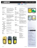
Map page
1
Elevation page
(Vista Cx)
Hunt/fish
calendar
Upcoming turn page
eTrex
®
color series
c o m p a t i b l e
1
Shown with optional MapSource detail.
eTrex Legend
®
Cx
eTrex Vista
®
Cx
eTrex Venture
®
Cx