GPS in Schools – Inserting Placemarks in Google Earth
Produced by the University of Tasmania in conjunction with Geoscience Australia as part of the AuScope GPS in Schools Project – 2014.
20
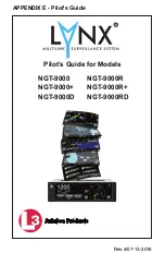
9.
Ensure that all Placemarks are in the folder you created. If not, drag and drop the Placemarks into the
folder.
10.
Right Click on the folder and choose
Save Place As
.