background image

Garmin aera 660 Pilot’s Guide

190-02017-20 Rev. A

Appendix G

155

Overview

Navigation

Flight Planning

Hazar

d A
voidance

Additional F

eatur

es

Appendices

Index

APPENDIX G:  UTILITIES

FLIGHT LOG

The Flight Log shows a list of any recorded flights, including date, route of flight, 

and flight time.  The aera saves up to 50 recorded flights.  Entries on this list are 
automatically created for each flight. 

Recording begins when your speed exceeds 30 knots and you gain 250 feet of 

altitude.  If you land and groundspeed drops below 30 knots, the flight entry is saved 
and a new entry is recorded when you depart the airport.  A touch-and-go or brief 
stop of less than 10 minutes appends to the current flight record, rather than starting 
a new entry. 

VIEWING THE FLIGHT LOG

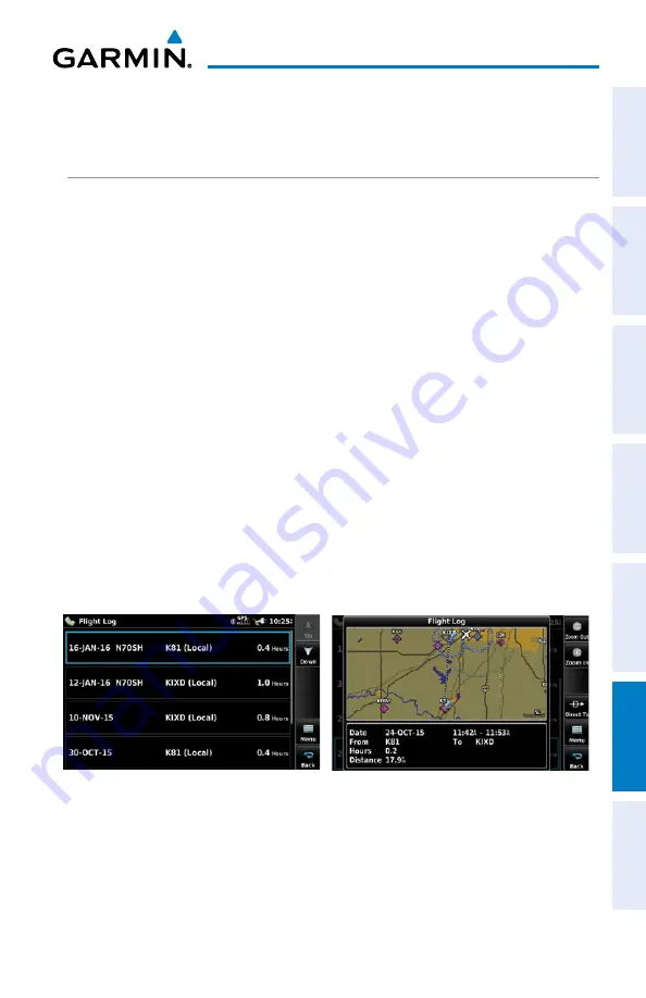
Select any listed entry in the log to view additional information, including a map 

displaying the actual path flown.

Viewing details for a flight:

1) 

From the 

Main Menu

, touch 

Tools

 > 

Flight Log

.

2) 

Touch the desired flight log.  Route, date, hours, distance, and the flight 
path are displayed.

Flight Log

Summary of Contents for AERA 660

Page 1: ...model 660 Pilot s Guide...

Page 2: ......

Page 3: ...OVERVIEW NAVIGATION FLIGHT PLANNING HAZARD AVOIDANCE ADDITIONAL FEATURES APPENDICES INDEX...

Page 4: ...Fax 44 0 238 052 4004 Aviation Support 44 0 370 850 1243 Garmin Corporation No 68 Zhangshu 2nd Road Xizhi District New Taipei City Taiwan Tel 34 93 357 2608 Fax 34 93 429 4484 Web Site Address www gar...

Page 5: ...www thisisant com directory for a list of compatible products and apps Jeppesen is a registered trademark of Jeppesen Inc NavData is a trademark of Jeppesen Inc AC U KWIK is a registered trademark of...

Page 6: ...n data is obtained from third party sources Garmin is not able to independently verify the accuracy of the terrain data WARNING The displayed minimum safe altitudes MSAs are only advisory in nature an...

Page 7: ...before continuing navigation WARNING The Garmin aera has a very high degree of functional integrity However the pilot must recognize that providing monitoring and or self test capability for all conce...

Page 8: ...o accurately depict all of the traffic within range of the aircraft Due to lack of equipment poor signal reception and or inaccurate information from aircraft or ground stations traffic may be present...

Page 9: ...ovided in accordance with California s Proposition 65 For questions or additional information please refer to our web site at www garmin com prop65 NOTE Use of polarized eyewear may cause the display...

Page 10: ...Garmin aera 660 Pilot s Guide 190 02017 20 Rev A Warnings Cautions Notes Blank Page...

Page 11: ...Garmin aera 660 Pilot s Guide 190 02017 20 Rev A RR 11 Part Number Change Summary 190 02017 20 Initial release Rev Date Description A March 2016 Production Release...

Page 12: ...Garmin aera 660 Pilot s Guide 190 02017 20 Rev A RR 12 Blank Page...

Page 13: ...s 8 Main Menu 10 1 4 Accessing System Functionality 14 Option Menus 14 Data Entry 15 1 5 Using Map Displays 17 Map Range 17 Map Panning 19 Map Overlays 21 Map Symbols 22 MAP Detail 22 1 6 System Setti...

Page 14: ...3 2 Flight Plan Creation 70 Adding Waypoints to an Existing Flight Plan 72 3 3 Flight Plan Storage 74 3 4 Flight Plan Activation 74 Editing Speed and Fuel Flow 75 Copying Flight Plans 76 Inverting a...

Page 15: ...iles and Databases 125 Connecting to a Computer 125 Managing Files 126 MicroSD Card Use Optional 127 Database Types 128 Database Purchase Installation and Updates 130 Appendix D Installation and Inter...

Page 16: ...ols 165 VFR Symbols 165 IFR Symbols 166 Airspace Symbols 168 Appendix I Map Datum and Location Formats 171 Map Datums 171 Location Formats 171 Appendix J Glossary 173 Appendix K License Agreement and...

Page 17: ...ces Index SECTION 1 OVERVIEW 1 1 UNIT OVERVIEW The aera 660 presents GNSS derived analog flight instrumentation position navigation and hazard avoidance information to the pilot using a 5 display with...

Page 18: ...ct contains a lithium ion battery To prevent damage remove the unit from the aircraft or vehicle when exiting or store it out of direct sunlight Installing the battery 1 Locate the lithium ion battery...

Page 19: ...in the aircraft and connect the power cable to the aircraft power outlet cigarette lighter receptacle 2 Route the power cable so that it does not interfere with aircraft operation The unit begins cha...

Page 20: ...base information is displayed Database information includes valid operating dates cycle number and database type When this information has been reviewed for currency to ensure that no databases have e...

Page 21: ...S Status Receiver Status Horizon 45 Above Horizon Constellation Diagram PRN Number PRN Number Signal Strength Bar Viewing the GNSS status From the Main Menu touch GPS Info GPS Tab ACQUIRING SATELLITES...

Page 22: ...eak or missing signal levels due to poor satellite coverage or installation problems As the GNSS receiver locks onto satellites a signal strength bar is displayed for each satellite in view with the a...

Page 23: ...ces Index 1 3 OPERATION BASIC TOUCHSCREEN OPERATION Touch the desired selection The icon menu option etc will momentarily turn blue when selected Basic Touchscreen Operation SCROLLING AND PANNING Scro...

Page 24: ...Appendices Index ZOOMING Zooming in and out on the touchscreen map displays Pinch fingers together zoom out or pull fingers apart zoom in Zoom In Zoom Out DEDICATED PAGE ICONS Dedicated Page Icons are...

Page 25: ...ditional Features Appendices Index Nearest Airports Page Dedicated Page Icons Scroll up OR Touch to zoom out Scroll down OR Touch to zoom in Nearest Group Icons Nearest Page Only OR Weather Group Icon...

Page 26: ...page or menu Map Displays the Map View Charts Displays the VFR or IFR charts 3D Vision Displays 3D Vision Nearest Displays the Nearest Page Waypoint Displays the Waypoint Information Flight Plan List...

Page 27: ...Displays nearest intersections VRP Displays nearest Visual Reporting Point VRP User WPT Displays nearest user waypoints City Displays nearest cities ARTCC Displays nearest ARTCCs Air Route Traffic Con...

Page 28: ...play the associated function Setup Displays third level Setup Icons User WPT Displays User Waypoints and Proximity Waypoints Flight Log Displays Flight Logs Track Log Displays Track Logs VNAV Displays...

Page 29: ...ight intensity timeout and color mode settings Sound Displays sound settings Units Displays unit settings Time Displays time settings Map Displays Navigation Map settings Position Displays position se...

Page 30: ...ht Planning Hazard Avoidance Additional Features Appendices Index 1 4 ACCESSING SYSTEM FUNCTIONALITY OPTION MENUS The aera 660 has a dedicated Icon that displays a context sensitive list of menu optio...

Page 31: ...ed in the data entry window Enter Exits the keypad function and accepts the changes Backspace Erases the current data Numeric Alpha Displays the numeric or alpha keypad Cancel Cancels a value that has...

Page 32: ...nning Hazard Avoidance Additional Features Appendices Index Entering predetermined data options Touch the Data Option Button to display a vertical list of data options if applicable or toggle two data...

Page 33: ...ports NAVAIDs airspaces airways land data highways cities lakes rivers borders etc with names Map Pointer information distance and bearing to pointer location of pointer name and other pertinent infor...

Page 34: ...a Map Scale of 3 nm Per Scale Width AUTO ZOOM Auto Zoom allows the aera 660 to change the map display range to the smallest range clearly showing the active waypoint Auto Zoom can be overridden by ad...

Page 35: ...ndow also appears at the bottom of the map display showing the bearing distance and time to the pointer from the aircraft s present position the elevation of the land at the position of the pointer or...

Page 36: ...ter from the Aircraft s Present Position Elevation at the Pointer Location Time En Route to the Pointer from the Aircraft s Present Posi tion Map Feature Button Green Arrow Indicat ing Multiple Featur...

Page 37: ...ture is highlighted an information box appears on the map and the highlighted map feature is displayed on the Map Feature Button If multiple features are present at the Map Pointer position green arro...

Page 38: ...nu touch Map Menu 2 Touch VFR IFR Terrain Topo Shading Weather or Animate Weather to display or remove the map overlay MAP SYMBOLS Refer to Appendix H for a list of map symbols MAP DETAIL The map can...

Page 39: ...low management of the following system parameters Display Sound Units Time Map Position Interface Alarms Airpace Data Link Bluetooth WiFi Power 3D Vision Restoring system setting defaults 1 From the M...

Page 40: ...centage triangle to adjust the desired backlight intensity percentage Or Press the POWER Button to quickly access the backlight intensity BACKLIGHT TIMEOUT When running on battery power after a specif...

Page 41: ...OTS Enabling disabling screenshots 1 From the Main Menu touch Tools Setup Display 2 Touch On or Off in the Screenshot field An SD card is required AIRCRAFT POSITION Showing hiding the aircraft positio...

Page 42: ...nable disable Terrain Audio or Key Tone Or Press the POWER Button to quickly access the Master volume mute Muting sound See the Adjusting the Sound procedure above MAP SETUP AUTOZOOM Enabling disablin...

Page 43: ...TYPE Setting the aircraft type 1 From the Main Menu touch Tools Setup Data Link 2 Touch Pressurized in the Aircraft Type field to toggle it On Off ADS B TRAFFIC DATA Enabling disabling ADS B Traffic...

Page 44: ...f 1 From the Main Menu touch Tools Setup Wi Fi 2 Touch Off 3D VISION SETUP Setting up 3D Vision 1 From the Main Menu touch Tools Setup 3D Vision 2 Touch the Bug Indicator Data Option Button and touch...

Page 45: ...tion Sound Master Volume Alert Volume Message Volume Terrain Audio Key Tone Units Distance Speed Direction Display Temperature Altitude Vertical Speed Pressure Fluid Volume Time Time Format Auto UTC O...

Page 46: ...surface Hard or Soft shows all runways except water landing facilities Water Only shows only water landing facilities Any shows any runway regardless of surface type including water landing facilities...

Page 47: ...rrent position in relation to a prominent landmark The pilot can change the reference waypoint Nearest Type using the Change Nearest Type menu option By default the Nearest Type is set to Automatic wh...

Page 48: ...d 1 10 SIMULATOR MODE Simulator Mode is helpful for practicing with the unit indoors or when no satellite signals are available All waypoints and routes created in Simulator Mode are retained in memor...

Page 49: ...Garmin aera 660 Pilot s Guide 190 02017 20 Rev A 33 Overview Overview Navigation Flight Planning Hazard Avoidance Additional Features Appendices Index Simulator Mode...

Page 50: ...Garmin aera 660 Pilot s Guide 190 02017 20 Rev A 34 Overview Overview Navigation Flight Planning Hazard Avoidance Additional Features Appendices Index Blank Page...

Page 51: ...ORTH UP Track Up TRK UP or Desired Track Up DTK UP An aircraft icon is placed on the Navigation Map at the location corresponding to the calculated present position The aircraft position and the fligh...

Page 52: ...ata Fields By default the Data Bar Fields are set to display Ground Speed GS Distance Next DIST NEXT Vertical Speed Required VSR and Time En Route Next ETE NEXT These four data fields can be changed t...

Page 53: ...Safe Altitude ESA External Voltage EXT VOLTS Flight Timer FLT TIMER Fuel Timer Glide Ratio G R Ground Speed GS Ground Track TRK Minimum Safe Altitude MSA Next Waypoint NEXT WPT Sunrise Sunset Time En...

Page 54: ...e Navigation Map The magenta bug indicator similar to the bug indicator on the HSI can be set by touching TRK on the 3D Vision Page Compass Arc Navigation Map Compass Arc Magenta Bug Indicator Display...

Page 55: ...3DVision to be disabled until it is restored The 3D Vision terrain display shows land contours colors are consistent with those of the topographical map display large water features towers and other...

Page 56: ...Vision Round Gauges 3D VISION OPERATION 3D Vision is accessed from the Main Menu Viewing 3D Vision From the Main Menu touch 3D Vision Display instrument tapes or round gauges From the Main Menu touch...

Page 57: ...compass direction from the present position to a destination waypoint DesiredTrack is the recommended direction to steer in order to reduce cross track error and return to the course line The Course...

Page 58: ...3D Vision Menu More Options 2 Touch the Bug Indicator Data Option Button and touch the desired option from the list User Selected Bearing Desired Track or Off Manually Setting a Course Touch CRS on t...

Page 59: ...ground speed is greater than 35 knots The Approaching VNAV Profile message appears one minute prior to the initial descent point The descent angle locks to prevent changes in speed from altering the p...

Page 60: ...altitude The VNAV Indicator appears Altimeter when displayed as a teal pointer A message appears when approaching the VNAV Profile When the teal pointer is in the vertical center of the altimeter the...

Page 61: ...on Waypoint Enter any waypoint along the currently active route as the reference waypoint The reference waypoint defines the target location Profile Enter the descent rate Altitude Enter the desired r...

Page 62: ...position Flight plan legs User waypoints Track vector Topography data MAP ORIENTATION Maps are shown in one of three different orientation options allowing flexibility in determining aircraft positio...

Page 63: ...Page Icon and touch the General Group 3 Touch the Orientation Data Option Button and touch the desired option from the list North Up Track Up or DTK Up AIRPORTS NAVAIDS CITIES ROADS Setting up and cus...

Page 64: ...turboprops and turbocharged piston aircraft operating above 18 000 feet MSL Jet Routes start at 18 000 feet MSL and extend upward to 45 000 feet MSL altitudes above 18 000 feet are called flight level...

Page 65: ...s matching the characters which have been entered up to that point A direct to navigation leg to the selected waypoint can be initiated by pressing the Icon The waypoint function allows the pilot to r...

Page 66: ...the Search Name or Search City Tab c Touch the Search by Facility Name or Search by City button d Enter the facility name or city using the keypad and touch Enter Or a Touch Find b Touch the Recent N...

Page 67: ...t for the entered facility name or location duplicate waypoints are displayed Touch the desired waypoint from the list 5 If multiple runways exist touch the Runway Button and touch the desired runway...

Page 68: ...RMATION The aera provides a Nearest function which gives the pilot quick access to nearest airport weather VOR NDB intersection user waypoint city ARTCC FSS and airspace information If there are none...

Page 69: ...light Service Station name bearing distance frequency and VOR if applicable Airspace name time to entry when applicable and status Viewing nearest information 1 From the Main Menu touch Nearest 2 Touc...

Page 70: ...h and Any for runway surface type Private airports and Heliports can also be included The NearestAirports Option Menu also allows the pilot to choose between displaying the facility names city names b...

Page 71: ...ed identifier displayed refer to Map Panning in the Overview Section for more information The weather information is displayed Or 1 From the Main Menu touch the Map Icon 2 Touch the desired METAR Flag...

Page 72: ...Intersections User Waypoints Cities ARTCCs FSSs and Airspace can be viewed using the Waypoint Information function the Nearest function or the Map Panning function Additional Information Airport VOR...

Page 73: ...fier Field to begin entering the desired intersection Refer to the Overview Section on Data Entry for more information Or 1 From the Main Menu touch Nearest 2 Touch the Dedicated Page Icon and touch I...

Page 74: ...rview Section on Map Panning for more information The intersection information is displayed VORS VOR information can be viewed using the Waypoint Information function the Nearest function or the Map P...

Page 75: ...d VOR displayed refer to the Overview Section on Map Panning for more information The intersection information is displayed USER WAYPOINTS The aera can create and store up to 3 000 user defined waypoi...

Page 76: ...oint settings symbol altitude location or reference waypoints continue with Step 4 4 If desired touch the Symbol Field to change the symbol that will appear on the map a Touch the desired symbol b Tou...

Page 77: ...tion a Touch the Waypoint Field s to enter the desired waypoint b Touch the Bearing and or Distance Fields to enter the desired values c Touch OK Reference Waypoints Selecting and viewing nearest user...

Page 78: ...Entry for more information Or a Touch the Location Button b Enter the desired latitude and longitude by touching the left right arrows to move the cursor and the up down arrows to change the value 5 T...

Page 79: ...w will appear 3 Touch Yes CITIES City information can be viewed using theWaypoint Information function the Nearest function or the Map Panning function The Nearest City function can be used to quickly...

Page 80: ...s displayed Select an ARTCC 1 From the Main Menu touch Nearest 2 Touch the Dedicated Page Icon and touch ARTCC FSS FSS information can be viewed using the Nearest function The Nearest FSS function can...

Page 81: ...to view frequencies associated with that airspace Nearest Airspace Airspace Alert Messages If airspace alarms are set to On default is Off the aera will display a message which includes the airspace n...

Page 82: ...the desired On Off Button s Airspace Alert Message Smart Airspace SmartAirspace shows airspace at and immediately surrounding the aircraft s current altitude in bold Airspaces at all other altitudes...

Page 83: ...the right side of most pages Once a direct to is activated the aera establishes a point to point course line from the present position to the selected direct to destination Course guidance is provided...

Page 84: ...ch Enter 4 Touch Activate Selecting a nearby airport as a direct to destination 1 From the Main Menu touch Nearest 2 Touch the Dedicated Page Icon and touch Airport 3 Touch the desired nearest airport...

Page 85: ...mation from the current database to define the waypoints If the database is changed or updated the aera automatically updates the information if the procedure has not been modified If an approach is n...

Page 86: ...from the list The currently selected Data Field is outlined blue 4 If desired repeat Steps 2 3 for the remaining Data Fields Data Field Button Flight Plan Data Fields 3 2 FLIGHT PLAN CREATION The acti...

Page 87: ...ouch Search by Facility Name d Enter the desired Facility Name using the keypad e Touch Enter Or a Touch Find b Touch the Search City Tab c Touch Search by City d Enter the desired City using the keyp...

Page 88: ...Touch the desired waypoint from the list 5 Repeat Steps 2 4 to enter each additional waypoint ADDING WAYPOINTS TO AN EXISTING FLIGHT PLAN Waypoints can be added to the active flight plan or any stored...

Page 89: ...tered facility name or location duplicate waypoints are displayed Touch the desired waypoint from the list Loading an approach procedure into a stored flight plan AnApproach Procedure can be loaded at...

Page 90: ...n List 2 Touch the desired saved flight plan An option menu is displayed 3 Touch Edit Flight Plan List Storing an active flight plan 1 With the Active Flight Plan displayed touch Menu 2 Touch Save Cop...

Page 91: ...vating a Flight Plan Leg 1 From the Main Menu touch Active Flight Plan 2 While navigating an active flight plan touch the desired leg to be activated An option menu automatically appears 3 Touch Activ...

Page 92: ...can be deleted from the aera memory Deleting a stored flight plan 1 From the Main Menu touch Flight Plan List and touch the desired Flight Plan 2 Touch Delete Yes Deleting all stored flight plans From...

Page 93: ...n which aircraft control is based solely upon flight instruments The approaches provided are for monitoring purposes only Only the final course segment final approach fix FAF to missed approach point...

Page 94: ...es not have a published approach the Select Approach menu option is not available An approach can be selected using the Direct to Active Flight Plan and the Saved Flight Plan functions Selecting an ap...

Page 95: ...er activating an approach Whenever an approach is selected and activated the procedure is added to the end of the flight plan and the aera immediately begins to provide guidance to the first waypoint...

Page 96: ...ting Cancelling Vectors to Final 1 From the Main Menu touch Active Flight Plan 2 While navigating an Active Flight Plan with an approach activated touch the Menu Icon 3 Touch the active approach 4 Tou...

Page 97: ...the weather traffic device must be within range and line of sight of an operating GBT Reception may be affected by altitude terrain and other factors FIS B weather products include METARs TAFs NEXRAD...

Page 98: ...erval in the table below If for any reason a weather product is not refreshed within the Expiration Time intervals see table the data is considered expired and is removed from the display This ensures...

Page 99: ...ar is a network of multiple high resolution Doppler radar sites that are operated by the National Weather Service NWS NEXRAD data provides centralized meteorological information for the continental Un...

Page 100: ...es Some but not all of those include Ground clutter Strobes and spurious radar data Sun strobes when the radar antenna points directly at the sun Military aircraft deploy metallic dust chaff which can...

Page 101: ...ation intensity is displayed using colors corresponding to the dBZ values NEXRAD Data RADAR Legend FIS B Radar Products FIS B weather provides two different Radar products CONUS and Regional The syste...

Page 102: ...ents up to 39 000 feet MSL Winds Aloft are displayed using wind barbs The wind barbs indicate wind speed and direction The wind barbs always point in the direction that the wind is coming from The win...

Page 103: ...ogical Aerodrome Report is an international code used for reporting weather observations METARs are updated hourly or as needed METARs typically contain information about the temperature dewpoint wind...

Page 104: ...00 to below 1000 feet AGL and or visibility 1 mile to less than 3 miles Low IFR ceiling below 500 feet AGL or visibility less than 1 mile METAR text does not contain adequate information to determine...

Page 105: ...e surface and tornadoes A SIGMET is widespread and must affect or be forecast to affect an area of at least 3 000 square miles SIGMETs are displayed as a yellow dashed line Map Feature Button AIRMET S...

Page 106: ...REPs provide timely weather information for a particular route of flight When significant weather conditions are reported or forecast AirTraffic Control ATC facilities are required to solicit PIREPs A...

Page 107: ...duct may be significantly older than the indicated weather product age FIS B Weather Products can be displayed on the Map Page and individually on the Weather WX Page The setup menu for the Map Page c...

Page 108: ...if available Setting up and customizing weather data for the Navigation Map 1 From the Main Menu touch Map Menu Set Up Map 2 Touch the Dedicated Page Icon and touch Weather 3 Touch On Off to display F...

Page 109: ...y contain inaccuracies Terrain and obstructions are shown only if they are in the database Terrain and obstacle information should be used as an aid to situational awareness They should never be used...

Page 110: ...function the Map View and the Profile View The areas of the terrain shaded red are predicted to be within 100 feet below or above the aircraft The yellow terrain areas are between the user defined Cau...

Page 111: ...e CAUTION Yellow obstacle is between 100 and 1000 below current aircraft altitude Terrain Obstacle Colors and Symbology TERRAIN AND OBSTACLE COLOR CODE Red terrain or obstacle is above or within 100 f...

Page 112: ...is above or within 100 ft below the aircraft Yellow Terrain is Between the User defined Caution Elevation and 100 ft Below the Aircraft Potential Impact Point Terrain Map Only View TERRAIN ALERTS SETU...

Page 113: ...From the Main Menu touch Terrain 2 Touch Menu 3 Touch Caution Elevation and touch 500ft Below 750ft Below or 1000ft Below 4 Touch Look Ahead Time and touch 60 Seconds 90 Seconds or 120 Seconds 5 Touch...

Page 114: ...ns meet parameters that are set within the software algorithms and are dependant on the sensitivity level set in the Terrain Setup Menu Alert Severity Terrain Obstacle Descent Rate Caution caution ter...

Page 115: ...own aircraft altitude is shown above the target symbol if traffic is above own aircraft altitude and below the symbol if they are below own aircraft altitude Altitude trend is shown as an up arrow 50...

Page 116: ...t the Traffic Warning Window is shown The Traffic WarningWindow shows a small pop up map in the lower left corner The Range Rings on the pop up alert are spaced every whole mile kilometer nautical mil...

Page 117: ...Pointer Traffic Ground Track DATA LINK TRAFFIC ADS B Automatic Dependent Surveillance Broadcast is a surveillance technology deployed across the United States as the cornerstone of the FAA s Next Gen...

Page 118: ...information ADS B Out refers to the capability to transmit ADS B information ADS B participating refers to the capability to both send and receive ADS B information Aircraft lacking either ADS In ADS...

Page 119: ...ating aircraft is within the GBT s defined service volume In this case a GBT will only rebroadcast TIS B information relative to the ADS B participating aircraft Only traffic that is within 15 nm late...

Page 120: ...raft or ground stations traffic may be present that is not represented on the display Viewing the weather traffic device status 1 From the Main Menu touch Tools 2 Touch Data Link SYSTEM STATUS The tra...

Page 121: ...Main Menu touch Tools Data Link 2 Touch Menu Set Up Data Link 3 Touch the Aircraft Type Pressurized button to toggle pressurized aircraft on off TRAFFIC DESCRIPTION ADS B traffic operation is similar...

Page 122: ...outer range ring at proper bearing Directional airborne Traffic Advisory TA with absolute vector Points in the direction of the aircraft track Directional off scale airborne Traffic Advisory TA Points...

Page 123: ...C ALERTS ADS B TIS B A traffic audio alert is generated whenever the number of Traffic Advisories on the aera display increases Limiting Traffic Advisories only reduces the nuisance alerting due to pr...

Page 124: ...al mile Touch the Traffic Warning Window to acknowledge and remove it DISPLAYING TRAFFIC DATA Traffic is displayed by default on the Map Page and in the Traffic Warning Window Traffic Symbol and Traff...

Page 125: ...to the Map Page Viewing the Traffic Page From the Main Menu touch Traffic Changing the Altitude Filter 1 From the Main Menu touch Traffic Menu Altitude Filter 2 Touch the desired setting Unrestricted...

Page 126: ...IDs of other aircraft when available can be displayed on the Traffic Page When a Flight ID or call sign is received it will appear below the corresponding traffic symbol when enabled Aircraft Identifi...

Page 127: ...location relative to the predicted location at the end of the look ahead time For example if traffic is ahead of the aircraft and traveling along the same track but at a slower rate The motion vector...

Page 128: ...rd Avoidance Additional Features Appendices Index Motion vector selection is made from the Traffic Page Menu by enabling disabling TargetTrend Absolute vectors are selected by default and are replaced...

Page 129: ...andmarks including ramps buildings control towers and other prominent features Resolution is greater at lower map ranges The SafeTaxi feature can be seen on the Navigation Map or from the Waypoint Inf...

Page 130: ...ching the Tools Database The SafeTaxi database is provided by Garmin Refer to Appendix C for instructions on updating the SafeTaxi database 5 2 AIRPORT DIRECTORY DATA The Airport Directory contains ai...

Page 131: ...h Enter Or a Touch Find b Touch the Recent Nearest Airports Flight Plan or User Tab c Touch the desired waypoint Or a Touch Find b Touch the Search Name Tab c Touch Search by Facility Name d Enter the...

Page 132: ...any map highlight an airport using the Map Pointer 2 Touch the Map Feature Button 3 Touch the AOPA Tab if necessary Icon Description Restaurant on Field Self Serve Fuel Courtesy Car Airport Directory...

Page 133: ...e maps was found All MapSource maps are not accessible Database Error Internal problem with the system Contact a Garmin dealer or Garmin Product Support to have the unit repaired Fuel Tank A reminder...

Page 134: ...f 25 degrees to stay on course Track Already Exists A saved track with the same name already exists Track Log Full The track log is full and track recording was turned off To record more track points...

Page 135: ...Definition Accuracy The current accuracy of the GPS determined location Altitude The current altitude in geometric height above Mean Sea Level MSL Bearing The compass direction from the present posit...

Page 136: ...n Next Waypoint The next waypoint in the flight plan or direct to route Sunrise The time at which the sun rises on this day current location Sunset The time at which the sun sets on this day current l...

Page 137: ...ltitude to the previously selected VNAV position and altitude based upon current groundspeed Weather Altimeter The altimeter setting at the nearest METAR reporting station Weather Dew Point The dew po...

Page 138: ...ameters that are set within the software algorithms and are dependant on the sensitivity level set in the Terrain Setup Menu Alert Severity Terrain Obstacle Descent Rate Caution caution terrain cautio...

Page 139: ...ra loses the GNSS signal for any reason the following will occur A blinking red question mark will appear over the airplane icon on the map The Lost Satellite Reception message will display Any GNSS d...

Page 140: ...Garmin aera 660 Pilot s Guide 190 02017 20 Rev A Appendix B 124 Overview Navigation Flight Planning Hazard Avoidance Additional Features Appendices Index Blank Page...

Page 141: ...nection Mini USB Connector Connecting the aera to a computer 1 Optional Step Insert a memory card into the memory card slot Press it in until it clicks 2 Turn the unit on 3 Connect the small end of th...

Page 142: ...File Types MAPSOURCE DETAILED MAPS The included USB Interface Cable is used to transfer MapSource CD ROM data to the aera internal memory or optional MicroSD Card For compatible MapSource products re...

Page 143: ...he aera internal memory or MicroSD Card such as MapSource detailed maps in a MapSource program MicroSD Card Slot MicroSD Slot Installing an MicroSD Card 1 Firmly push the card into the unit It is not...

Page 144: ...database It is very important to note that not all obstacles are necessarily charted and therefore may not be contained in the obstacle database This database is updated on a 56 day cycle and does not...

Page 145: ...ports VORs NDBs and more There are two navigation database products available the Garmin Navigation database containing coverage for North America expanded coverage is planned for the future and the J...

Page 146: ...NDBs VORs and airports is consistent with those used on a sectional chart NOTE After performing a navigation database update verify all flight plan s routes are current If there is an obsolete aviati...

Page 147: ...3 From the Main Menu touch Tools Downloads 4 If necessary touch the desired database to Download and touch the Download button 5 If necessary touch the desired database to Install and touch the Insta...

Page 148: ...Garmin aera 660 Pilot s Guide 190 02017 20 Rev A Appendix C 132 Overview Navigation Flight Planning Hazard Avoidance Additional Features Appendices Index Blank Page...

Page 149: ...ner operator of the aera to place this mount and secure the unit so that it will not interfere with the aircraft s operating controls and safety devices or cause damage or personal injury in the event...

Page 150: ...the yoke shaft or control arm Install the yoke mount as far from the panel as is practical 2 When in place tighten the Clamp Adjustment Knob to secure the yoke mount to the yoke shaft or control arm 3...

Page 151: ...w Navigation Flight Planning Hazard Avoidance Additional Features Appendices Index aera Cradle Release Button aera Cradle Adjustment Knob Yoke Mount Assembly Connecting the cables Make all applicable...

Page 152: ...ent Knob spacer and rubber washer 2 Rotate the clamp assembly 90o so that the clamp opening faces away from you 3 Secure the clamp assembly to the rest of the yoke mount using the Cradle Adjustment Kn...

Page 153: ...mbly can be easily removed from the yoke shaft or control arm CONNECTING TO A GARMIN VHF COMM RADIO The aera can also output frequency data to a Garmin aviation radio For additional information refer...

Page 154: ...requency data to a SL40 SL30 GTR 200 GTR 225 or GNC 255 nav comm radio 1 Connect the aera to the applicable nav comm radio using the Aviation Bare Wire Connector optional accessory aera Aviation Bare...

Page 155: ...en connecting the aera to a USB port the computer prompts you to locate the destination of the drivers for the device Only install the drivers once After the drivers are installed your computer always...

Page 156: ...ols Setup Interface Menu Restore Default Serial Data Formats None Provides no interfacing capabilities NMEA Out Transmits NMEA position velocity and navigation data Aviation In The proprietary format...

Page 157: ...Touch NMEA Output Mode to toggle between Normal or Fast NMEA Sentence Output Normal Mode GPRMB GPRMC GPGGA GPGSA GPGSV GPGLL GPBWC GPVTG GPXTE GPBOD GPRTE GPWPL GPAPB PGRME PGRMZ PGRMM and PGRMH Fast...

Page 158: ...nsponder was lost aera Aviation Bare Wire Connections CONNECTING TO A GDL 39 GDL 39R To receive weather and traffic information from the GDL 39 GDL 39R the GDL 39 GDL 39R must be connected to the aera...

Page 159: ...ed connection update status from the Main Menu touch Tools Data Link CAUTION Never remove power from the aera or GDL 39 GDL 39R during a software update Anytime the aera software is updated it may als...

Page 160: ...dditional Features Appendices Index NOTE External GPS Antenna not required on either GDL 39 or GDL 39R when connected to aera 660 NOTE External UAT Antenna should be mounted on bottom of aircraft with...

Page 161: ...Serial Data Format data field button A vertical list is displayed 4 Touch Connext 57600 Baud When recognized the GTX 345 device and connections information is shown 5 From the GTX 345 press the ON and...

Page 162: ...is turned on From the Main Menu touch Tools Setup Bluetooth On 2 Touch Not Paired next to the GTX Device A Bluetooth Passkey window will open 3 Touch OK The GTX 345 is now connected NOTE Only one Blue...

Page 163: ...System Settings chapter of this section Do not leave the unit in direct sunlight in a cool not freezing place When storing the unit store within the following temperature ranges safe storage 15 to 55...

Page 164: ...rs and solvents that can damage plastic components CLEANING THE TOUCHSCREEN The aera 660 display uses a lens coated with a special coating that is very sensitive to abrasive cleaners AVOID CHEMICAL CL...

Page 165: ...ppendix E 149 Overview Navigation Flight Planning Hazard Avoidance Additional Features Appendices Index AVOIDING THEFT Remove the unit from sight when not in use Do not keep the unit in the glove comp...

Page 166: ...Garmin aera 660 Pilot s Guide 190 02017 20 Rev A Appendix E 150 Overview Navigation Flight Planning Hazard Avoidance Additional Features Appendices Index Blank Page...

Page 167: ...mation Service TIS A provides traffic advisory information to non TAS TCAS equipped aircraft TIS A is a ground based service providing the relative locations of all ATCRBS Air Traffic Control Radar Be...

Page 168: ...ce maneuvers are given nor authorized as a direct result of a TIS A intruder display or TIS A advisory TIS A operation may be intermittent during turns or other maneuvering TIS A is dependent on two w...

Page 169: ...bruptly the tracking algorithm may report incorrect horizontal position until the maneuvering aircraft stabilizes When a rapidly closing intruder is on a course that intercepts the client aircraft cou...

Page 170: ...Garmin aera 660 Pilot s Guide 190 02017 20 Rev A Appendix F 154 Overview Navigation Flight Planning Hazard Avoidance Additional Features Appendices Index Blank Page...

Page 171: ...d exceeds 30 knots and you gain 250 feet of altitude If you land and groundspeed drops below 30 knots the flight entry is saved and a new entry is recorded when you depart the airport A touch and go o...

Page 172: ...ht records 1 From the Main Menu touch Tools Flight Log 2 Touch the desired flight log if applicable 3 Touch Menu Delete Flight Yes TRACK LOG The aera draws an electronic breadcrumb trail or track log...

Page 173: ...and touch Show or Hide Changing track log settings 1 From the Main Menu touch Map Menu Set Up Map 2 Touch the Dedicated Page Icon and touch the Line Group 3 Touch the Track Log Record Mode button and...

Page 174: ...From the Main Menu touch Tools Track Log Menu Save Active Track 2 Touch the Save button and touch Entire Active Track Past 24 Hours Past 7 Days Selected Flight or Specific Dates 3 Enter the Selected F...

Page 175: ...is selected use the keypad to enter the desired distance and touch Enter 5 If Time is selected use the buttons to select the desired time E6B CALCULATOR The E6B Calculator calculates Density Altitude...

Page 176: ...tly for winds aloft calculations Tail Wind calculated figure determined from entry of heading and true airspeed Wind From calculated figure determined from entry of heading and true airspeed Wind Spee...

Page 177: ...nd Wind Speed are calculated NOTE If True North is selected as the heading reference a heading referenced to True North must be used to calculate winds accurately Restoring E6B calculator defaults Fro...

Page 178: ...he weight and balance conditions of the aircraft By entering the weight and arm values the aera can calculate the total weight moment and center of gravity CG Before entering the various figures the e...

Page 179: ...o define an alarm circle around a waypoint location Proximity Waypoints Proximity Circle Proximity Alarm Defining proximity waypoints 1 From the Main Menu touch Tools User Waypoint Proximity Tab Menu...

Page 180: ...int Proximity Tab Menu Enable Disable Proximity Alarms Or 1 From the Main Menu touch Map Menu Set Up Map 2 Touch the Dedicated Page Icon and touch the Point Group 3 Touch the Proximity Circle button a...

Page 181: ...wered Non serviced Towered Non serviced Non towered Serviced Towered Serviced Soft Surface Non serviced Soft Surface Serviced Soft Surface Private Paved Private Seaplane Base Heliport Americas Pacific...

Page 182: ...ompass locator at outer marker NDB non directional radio beacon VOR VOR DME ILS DME or DME only VORTAC TACAN Navaids Item Symbol Interstate Highway US Highway State Highway National Highway Small City...

Page 183: ...serviced IFR Airport Non serviced VFR Airport Serviced IFR Airport Serviced VFR Soft Surface Non serviced VFR Soft Surface Serviced VFR Soft Surface Private VFR Paved Private VFR Seaplane Base VFR He...

Page 184: ...s E CTA Class A Class C TMA Class D Mode C Veil TRSA MOA Danger Alert or Training Area Restricted Prohibited or Warning Area Radar Area ATZ TIZ MATZ ADIZ Misc Unknown VFR Americas Pacific Database Ite...

Page 185: ...verview Navigation Flight Planning Hazard Avoidance Additional Features Appendices Index Item Symbol Danger or Alert Area Restricted Prohibited or Warning Area Training Area VFR Atlantic Database Exce...

Page 186: ...Garmin aera 660 Pilot s Guide 190 02017 20 Rev A Appendix H 170 Overview Navigation Flight Planning Hazard Avoidance Additional Features Appendices Index Blank Page...

Page 187: ...nd calculated on this reference surface Lines of latitude and longitude on a chart are referenced to a specific map datum Every chart has a map datum reference and the aera can be set to match most of...

Page 188: ...Garmin aera 660 Pilot s Guide 190 02017 20 Rev A Appendix I 172 Overview Navigation Flight Planning Hazard Avoidance Additional Features Appendices Index Blank Page...

Page 189: ...oadcast AGL Above Ground Level AIRMET Airman s Meteorological Information ARTCC Air Route Traffic Control Center ASOS Automated Surface Observing System ATC Air Traffic Control ATIS Automatic Terminal...

Page 190: ...Desired Track Enroute Safe Altitude The recommended minimum altitude within ten miles left or right of the desired course on an active flight plan or direct to ESA Enroute Safe Altitude Estimated Time...

Page 191: ...nd clears the highest elevation reference point in the grid by 1000 feet for all areas of the grid Ground Based Transceiver Provides ADS R TIS B and FIS B broadcasts to ADS B participating aircraft Gr...

Page 192: ...aircraft panel in HG inches of mercury kg kilogram kHz kilohertz km kilometer kt knot LAT latitude lb pound Leg The portion of a flight plan between two waypoints LOC localizer LON longitude m meter...

Page 193: ...ons per minute SBAS Satellite Based Augmentation System SD Secure Digital sec second s SIGMET Significant Meteorological Information TA Traffic Advisory TACAN Tactical Air Navigation System TAF Termin...

Page 194: ...Index UTC Coordinated Universal Time VFR Visual Flight Rules VHF Very High Frequency VNAV vertical navigation VOR VHF Omni directional Range VORTAC very high frequency omnidirectional range station an...

Page 195: ...reverse assemble reverse engineer or reduce to human readable form the Software or any part thereof or create any derivative works based on the Software You agree not to export or re export the Softw...

Page 196: ...tional Purchases A separate warranty is provided by international distributors for units purchased outside the United States This warranty is provided by the local in country distributor and this dist...

Page 197: ...s device must accept any interference received including interference that may cause undesired operation This equipment has been tested and found to comply with the limits for a Class B digital device...

Page 198: ...n uncontrolled environment This equipment should be installed and operated with a minimum distance of 20 centimeters between the radiator and your body This transmitter must not be co located or opera...

Page 199: ...18 B Backlight 24 Baro Pressure 159 Battery Charging 3 Information 147 Installation 2 Life 147 Replacement 147 BKSP 15 Bluetooth 27 28 130 146 Bug Indicator 42 C Calibrated Airspeed 160 CDI Scale 42...

Page 200: ...6 Intersections 57 Inverting flight plans 77 L Location Formats 171 Loss of GPS Position 123 Lost Satellite Reception 5 M Managing Files 126 Map Autozoom 18 Declutter 22 Display Setup 46 Orientation 4...

Page 201: ...ettings Display 23 26 27 T TAFs 87 Temperatures Aloft 87 Terrain 93 Alerts 96 Audio 98 Aural Alerts 98 Views 95 Tools 12 Touchscreen 7 Touchscreen cleaning 148 Track Log 156 Traffic Data 100 Traffic G...

Page 202: ...Garmin aera 660 Pilot s Guide 190 02017 20 Rev A Index Index 4 Overview Navigation Flight Planning Hazard Avoidance Additional Features Appendices Index Y Yoke Mount 134 Z Zooming 8...

Page 203: ......

Page 204: ...r Road SE Salem OR 97302 U S A Tel 503 581 8101 Fax 503 364 2138 Garmin Europe Ltd Liberty House Hounsdown Business Park Southampton Hampshire SO40 9LR U K Tel 44 0 238 052 4000 Fax 44 0 238 052 4004...

Reviews: