background image


NX501E/NZ501E English  15 


2.2.3.3 Lane information and Signposts 

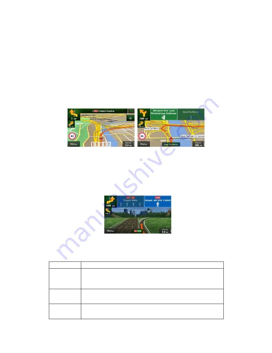
When navigating on multilane roads, it is important to take the appropriate lane in order to 
follow the recommended route. If lane information is available in the map data, Clarion Mobile 
Map displays the lanes and their directions using small arrows at the bottom of the map. 
Highlighted arrows represent the lanes you need to take. 

Where additional information is available, signposts substitute arrows. Signposts are 
displayed at the top of the map. The colour and style of the signposts are similar to the real 
ones you can see above road or by the roadside. They show the available destinations and 
the number of the road the lane leads to. 

All signposts look similar when cruising (when there is no recommended route). When 
navigating a route, only the signpost that points to the lane(s) to be taken is displayed in vivid 
colours; all others are darker. 

If you want to hide the currently displayed signposts, tap any of them and the normal Map 
screen returns until new signpost information is received. 


2.2.3.4 Junction view 

If you are approaching a motorway exit or a complex intersection and the needed information 
exists, the map is replaced with a 3D view of the junction. The lanes you need to take are 
displayed with arrows. Signposts can also be present if information is available. 

If you want to hide the currently displayed junction, tap the picture and the Map screen 
returns. 


2.2.3.5 3D object types 

Clarion Mobile Map supports the following 3D object types: 

Type 

Description 

3D terrain 

3D terrain map data shows changes in terrain, elevations or depressions in 
the land when you view the map in 2D, and use it to plot the route map in 
3D when you navigate. Hills and mountains are shown in the background of 
the 3D map, and illustrated by colour and shading on the 2D map. 

Elevated roads 

Complex intersections and vertically isolated roads (such as overpasses or 
bridges) are displayed in 3D. 

3D landmarks 

Landmarks are 3D artistic or block representations of prominent or well-
known objects. 

Summary of Contents for NX501E

Page 1: ...User Manual Clarion Mobile Map Navigation software for Clarion NX501E NZ501E UK English December 2010 ver 1 0 ...

Page 2: ...read this manual to fully understand the screens and features Easy navigation map updates It is easy to keep the navigation system up to date Simply download new map data from Clarion s portal site store them on a microSD card and insert it into the Clarion NX501E NZ501E via the front card slot Unpleasant surprises are now avoided as navigation maps will match the real world Latest Map Guarantee W...

Page 3: ... Navigation menu 22 3 Navigating 24 3 1 Selecting the destination of a route 24 3 1 1 Entering an address or a part of the address 24 3 1 1 1 Entering an address 24 3 1 1 2 Entering the midpoint of a street as the destination 27 3 1 1 3 Selecting an intersection as the destination 28 3 1 1 4 Selecting a city town centre as the destination 30 3 1 1 5 Entering an address with a postal code 31 3 1 1 ...

Page 4: ...s when planning the route 56 3 4 7 Checking route alternatives for an existing route 57 3 4 8 Changing the vehicle used in route planning 58 3 4 9 Changing the road types used in route planning 59 3 5 Saving a location as a Favourite destination 60 3 6 Saving a location as an alert point 61 3 7 Editing an alert point 61 3 8 Watching the simulation of the route 62 4 Reference Guide 64 4 1 Concepts ...

Page 5: ...NX501E NZ501E English 5 4 3 8 Display settings 78 4 3 9 Regional settings 78 4 3 10 Trip monitor settings 78 5 Glossary 80 6 End User Licence Agreement 82 7 Copyright note 86 ...

Page 6: ...e we recommend that you operate Clarion Mobile Map before you start your journey Plan the route before your departure and stop if you need to change the route You must obey the traffic signs and follow the road geometry If you deviate from the recommended route Clarion Mobile Map changes the instructions accordingly Never place NX501E NZ501E where it obstructs the driver s view where it is in the ...

Page 7: ...e application interface Later you can change it in Regional settings page 78 2 Read the End User Licence Agreement Tap to continue 3 The Configuration wizard starts Tap to continue 4 Select the language and speaker used for voice guidance messages Later you can change it in Sound and Warnings settings page 78 5 If needed modify the time format and unit settings Later you can change them in Regiona...

Page 8: ...figuration or you are about to lose some of your data or settings Otherwise Clarion Mobile Map saves your selections and applies the new settings without confirmation as soon as you use the controls Type Example Description How to use it Button Tap it to initiate a function to open a new screen or to set a parameter Tap it once Button with value Some buttons display the current value of a field or...

Page 9: ...ds to enter text and numbers Each key is a touch screen button 2 1 1 Using keyboards You only need to enter letters or numbers when you cannot avoid it You can type with your fingertips on the full screen keyboards and you can switch between various keyboard layouts for example English Greek or numerical Task Instruction Switching to another keyboard layout for example from an English keyboard to ...

Page 10: ...and keep pressing the following buttons to reach extra functions Tap and hold on list and menu screens the Map screen appears Tap and hold any of the and buttons on the Map screen you can rotate tilt or scale the map continuously Tap and hold on keyboard screens you can delete several characters quickly Tap and hold or in long lists you can scroll pages continuously Gestures drag drop You need to ...

Page 11: ...nding map area When there is no GPS position the Vehimarker is transparent It shows your last known position You see coloured dots circling around a satellite symbol in the top left corner The more green dots you see the closer you are to get the valid GPS position When GPS position is available the Vehimarker is displayed in full colour now showing your current position There are screen buttons a...

Page 12: ...ed in the top left corner of menu screens Default data fields when navigating a route tap and hold any of the fields to change its value Field Description Shows the distance you need to travel on the route before reaching your final destination Shows the time needed to reach the final destination of the route based on information available for the remaining segments of the route If NX501E NZ501E i...

Page 13: ...nt on the map The Cursor is displayed with a radiating red dot to make it visible at all zoom levels The location of the Cursor can be used as the destination of the route a new alert point you can search for Places around it or you can save this location as one of your Favourite destinations You can also select some of the objects on the map If you tap the map at the icon of a Place of Interest o...

Page 14: ...therwise only the next manoeuvre is displayed Most of these icons are very intuitive The following table lists some of the frequently shown route events The same symbols are used in both fields Icon Description Turn left Turn right Turn back Bear right Turn sharp left Keep left Continue straight in the intersection Go left on the roundabout 3rd exit next manoeuvre Enter roundabout second next mano...

Page 15: ...to hide the currently displayed signposts tap any of them and the normal Map screen returns until new signpost information is received 2 2 3 4 Junction view If you are approaching a motorway exit or a complex intersection and the needed information exists the map is replaced with a 3D view of the junction The lanes you need to take are displayed with arrows Signposts can also be present if informa...

Page 16: ...ation end point The final destination of the route Route colour The route always stands out with its colour on the map both in daytime and in night colour mode Streets and roads that are excluded from the navigation You can choose whether you want to use or avoid certain road types page 73 However when Clarion Mobile Map cannot avoid such roads the route will include them and it will show them in ...

Page 17: ...ant traffic events to let you quickly check them 2 2 4 Manipulating the map Tap the map anywhere to browse it during navigation The map stops following the current position the Vehimarker a red arrow by default is not locked in a fix position on the screen any more and control buttons appear to help you modify the map view Action Button s Description Moving the map with drag drop No buttons You ca...

Page 18: ... angle of the map Tap the button once to modify the view in large steps or tap and hold the button to modify it continuously and smoothly 2D or 3D view Tap this button to switch between the 3D perspective and 2D top down map view modes Compass in 2D map view mode The direction of the compass shows North Tap the button to switch to North up view and then tap again to rotate the map in the previous ...

Page 19: ...e number of buttons in the menu In Settings you can choose the function of each button page 73 The following options are available Button Description Shortcut for This function lets you search for a Place along your route or around your current location if there is no route calculated Find Find Places Quick Search page 34 This button opens the list of your Favourite destinations Find Favourite pag...

Page 20: ...dance page 77 This button opens the Traffic Summary screen Tap the Traffic icon in the Navigation menu or on the Map screen This button lets you bypass parts of the recommended route My Route Avoidances This button opens the Trip Monitor screen where you can manage your previously saved trip logs and track logs More Trip Monitor page 69 This button opens the list of manoeuvres the itinerary Tap th...

Page 21: ...You can access this screen from the map in one of the following ways If the current street is displayed below the Vehimarker the current position on the map tap it to open the Where Am I screen Open the Quick menu and tap the button Information on this screen Latitude and Longitude coordinate of the current position in WGS84 format Altitude elevation information coming from the GPS receiver often ...

Page 22: ...igation menu You can reach all parts of Clarion Mobile Map from the Navigation menu You have the following options Tap to select your destination by entering an address or selecting a place of interest a location on the map or one of your Favourite destinations You can also look up your recent destinations from the Smart History or enter a coordinate Tap to display the route parameters and the rou...

Page 23: ...te demo routes or to run some additional applications Tap to start navigating on the map The button itself is a miniature live map that shows your current position the recommended route and the surrounding map area Tap the button to enlarge the map to the full screen Tap to open the Traffic Summary screen ...

Page 24: ... street name without a house number or the names of two intersecting streets page 24 Enter an address with postal code page 31 This way you do not need to select the name of the city town and the search for street names might be faster as well Use a built in Place of Interest as your destination page 34 Select a location on the map with the Find on Map feature page 45 Use a previously saved Favour...

Page 25: ... a Tap b Start entering the name of the city town on the keyboard c Find the city town you need The most likely city town name is always shown in the input field To accept it tap If the desired name does not show up the names that match the string appear in a list after entering a couple of characters to open the list of results before it appears automatically tap Select the city town from the lis...

Page 26: ... entering the address If the entered house number cannot be found the midpoint of the street is selected as the destination 7 A full screen map appears with the selected point in the middle If necessary tap the map somewhere else to modify the destination The Cursor appears at the new location Tap to confirm the destination or tap to select a different destination 8 After a short summary of the ro...

Page 27: ... the house number is not available 1 If you are on the Map screen tap to return to the Navigation menu 2 In the Navigation menu tap the following buttons 3 If necessary modify the country and city town as described earlier page 24 4 Enter the street name a Tap b Start entering the street name on the keyboard c Find the street you need The most likely street name is always shown in the input field ...

Page 28: ...or tap to select a different destination 7 After a short summary of the route parameters the map appears showing the entire route The route is automatically calculated Tap to modify route parameters or tap and start your journey 3 1 1 3 Selecting an intersection as the destination To enter an address as the destination do as follows 1 If you are on the Map screen tap to return to the Navigation me...

Page 29: ...ir list appears immediately In case of a longer street the keyboard screen appears Start entering the name of the intersecting street on the keyboard As soon as the street names that match the entered string can be shown on one screen their list appears automatically Select from the list 6 A full screen map appears with the selected point in the middle If necessary tap the map somewhere else to mo...

Page 30: ...ng buttons 3 If necessary modify the country as described earlier page 24 4 Select the destination city town a Tap b Start entering the name of the city town on the keyboard c Find the city town you need The most likely city town name is always shown in the input field To accept it tap If the desired name does not show up the names that match the string appear in a list after entering a couple of ...

Page 31: ...calculated Tap to modify route parameters or tap and start your journey 3 1 1 5 Entering an address with a postal code All of the above address searching possibilities can be performed with entering the postal code instead of the city town name Find below an example with a full address 1 If you are on the Map screen tap to return to the Navigation menu 2 In the Navigation menu tap the following bu...

Page 32: ...et you need The most likely street name is always shown in the input field To accept it tap If the desired name does not show up the names that match the string appear in a list after entering a couple of characters to open the list of results before it appears automatically tap Select the street from the list 6 Enter the house number a Tap b Enter the house number on the keyboard To enter letters...

Page 33: ... search results All other characters are greyed out As you are typing the most likely result is always displayed in the input field If the guess is correct tap to select it After entering a couple of letters tap to list the items that contain the specified letters You can speed up finding an intersection Search first for the street with a less common or less usual name fewer letters are enough to ...

Page 34: ...ces with only a few screen taps you can search for a Place by its category you can search for a Place by its name In addition you can search for special services from the Where Am I screen 3 1 2 1 Quick search for a Place of Interest The Quick search feature lets you quickly find a Place by its name The search is always carried out along the recommended route if it exists or around your current lo...

Page 35: ...selected Place Tap to return to the map 7 If necessary tap the map somewhere else to modify the destination The Cursor appears at the new location Tap to confirm the destination or tap to select a different destination 8 After a short summary of the route parameters the map appears showing the entire route The route is automatically calculated Tap to modify route parameters or tap and start your j...

Page 36: ...nt position is not available either no GPS signal they are searched around the last known position If an active route exists restaurants are searched along the route If there is no active route destination is not selected they are searched around the current position If the current position is not available either no GPS signal they are searched around the last known position If an active route ex...

Page 37: ...Cursor appears at the new location Tap to confirm the destination or tap to select a different destination 9 After a short summary of the route parameters the map appears showing the entire route The route is automatically calculated Tap to modify route parameters or tap and start your journey 3 1 2 3 Searching for a Place of Interest by category You can search for Places of Interest by their cate...

Page 38: ...is useful when you search for a later stopover that results in a minimal detour only such as searching for upcoming petrol stations or restaurants The result list will be ordered by the length of the necessary detour 5 optional If you have selected select the city town to search in 6 Select one of the main Place categories e g Accommodation or tap to list all Places around the selected location or...

Page 39: ...eorder the list tap 11 Browse the list if necessary and tap one of the list items A full screen map appears with the selected point in the middle The name and address of the Place is displayed at the top of the screen 12 optional Tap to see the details of the selected Place Tap to return to the map 13 If necessary tap the map somewhere else to modify the destination The Cursor appears at the new l...

Page 40: ...n or if it is not available around the last know position The result list will be ordered by the distance from this position Tap to search for a place within a selected city town The result list will be ordered by the distance from the centre of the selected city town Tap to search for a place around the destination of the active route The result list will be ordered by the distance from the desti...

Page 41: ...f the main Place categories e g Accommodation to search in or tap to search among all Places 7 Select one of the Place subcategories e g Hotel or Motel to search in or tap to search in the selected Place category 8 Tap if you have not done it before 9 Using the keyboard start entering the name of the Place ...

Page 42: ...e is displayed at the top of the screen 13 optional Tap to see the details of the selected Place Tap to return to the map 14 If necessary tap the map somewhere else to modify the destination The Cursor appears at the new location Tap to confirm the destination or tap to select a different destination 15 After a short summary of the route parameters the map appears showing the entire route The rout...

Page 43: ...he selected point in the middle The name and address of the Place is displayed at the top of the screen 8 optional Tap to see the details of the selected Place Tap to return to the map 9 If necessary tap the map somewhere else to modify the destination The Cursor appears at the new location Tap to confirm the destination or tap to select a different destination 10 After a short summary of the rout...

Page 44: ... an instant list of that type of Places 5 optional The Places in the list are ordered by their distance from the current or last known position from the selected city town from the destination or by the length of the necessary detour If you need to reorder the list tap 6 Browse the list if necessary and tap one of the list items A full screen map appears with the selected point in the middle The n...

Page 45: ... start your journey 3 1 3 Selecting a map location as the destination 1 If you are on the Map screen tap to return to the Navigation menu 2 In the Navigation menu tap the following buttons 3 Locate your destination on the map move and scale the map as needed 4 Tap the location that you want to select as your destination The Cursor appears 5 Tap to select the Cursor as the destination 6 After a sho...

Page 46: ...splayed 3 Tap the Favourite that you want to set as your destination If necessary browse down to see more of the list or tap and enter a few letters from the name of the Favourite destination 4 A full screen map appears with the selected point in the middle If necessary tap the map somewhere else to modify the destination The Cursor appears at the new location Tap to confirm the destination or tap...

Page 47: ...creen tap and then tap this button can be added to the Quick menu in Settins page 73 If you are in the Navigation menu tap and then tap 2 A full screen map appears with the selected point in the middle If necessary tap the map somewhere else to modify the destination The Cursor appears at the new location Tap to confirm the destination or tap to select a different destination 3 After a short summa...

Page 48: ...hey were last selected If necessary scroll the list to see earlier destinations 3 Select a destination from the list 4 A full screen map appears with the selected point in the middle If necessary tap the map somewhere else to modify the destination The Cursor appears at the new location Tap to confirm the destination or tap to select a different destination 5 After a short summary of the route par...

Page 49: ...necessary tap then and enter the coordinate in UTM format 6 When finished tap 7 A full screen map appears with the selected point in the middle If necessary tap the map somewhere else to modify the destination The Cursor appears at the new location Tap to confirm the destination or tap to select a different destination 8 After a short summary of the route parameters the map appears showing the ent...

Page 50: ...ry tap the map somewhere else to modify the destination The Cursor appears at the new location Tap to confirm the destination or tap to select a different destination 6 After a short summary of the route parameters the map appears showing the entire route The route is automatically calculated Tap to modify route parameters or tap and start your journey Note Only geotagged JPG files contain locatio...

Page 51: ...ute points the start point of the route normally the current GPS position 5 Tap to select the destination 6 The Destination menu appears and you can select the destination of the route the same way as described in the previous sections 7 When the new destination is selected the list returns 8 To add more destinations tap where you want to insert the new route point in the list and repeat the above...

Page 52: ...s of information are displayed The name and or address of the destination Warning icons if any They provide extra information about your route e g unpaved roads or toll roads to be taken The total time of the route The total length of the route Estimated delay calculated from traffic events on your route The symbol of the vehicle type used in route calculation The route planning method e g Fast 4 ...

Page 53: ... when already having a route New Route Waypoint or Final Destination If you already have a recommended route and you select a new destination as described in the above sections the application will ask you whether to start a new route add a new waypoint intermediate destination to the route or append the newly selected destination at the end of the current route Tap to plan a new route to the newl...

Page 54: ...eir length in time and distance you can turn off the GPS receiver Then you can set the starting point of the route to a different location than the current GPS position 1 If you are on the Map screen tap to return to the Navigation menu 2 In the Navigation menu tap 3 If you already have a route tap If you are starting a new route tap 4 The first line is the start of the route normally the current ...

Page 55: ...ed location 8 To return to normal navigation tap 3 4 3 Editing the list of destinations Edit Route You can edit the route by modifying the list of destinations You can add or remove destinations modify the start position or reorder the list 1 If you are on the Map screen tap to return to the Navigation menu 2 In the Navigation menu tap 3 Tap 4 You have the following options Tap to add a new destin...

Page 56: ...ve route To cancel the navigated route do one of the following If you are on the Map screen tap and then tap If you have a route with waypoints you need to tap until all waypoints are deleted In the Navigation menu tap and then tap The active route is deleted with all its waypoints 3 4 6 Checking route alternatives when planning the route You can select from different route alternatives or change ...

Page 57: ...to return to the previous screen Clarion Mobile Map recalculates the route The orange line now shows the new recommended route 3 4 7 Checking route alternatives for an existing route To recalculate the active route with a different route planning method you can modify the Route settings page 73 There is another way to do this and to compare different route alternatives with the same route planning...

Page 58: ... scroll down for routes with different routing methods 7 Select one of the route alternatives then tap and hold for a few seconds to return to the Map screen Clarion Mobile Map recalculates the route The orange line now shows the new recommended route 3 4 8 Changing the vehicle used in route planning To recalculate the active route for a different vehicle do as follows These changes can also be ma...

Page 59: ... in route planning To recalculate the active route with different road type preferences do as follows These changes can also be made in Settings page 73 1 On the Map screen tap and then tap 2 Tap any of the listed road types to modify the route If needed scroll the list for all road types You have the following options their order depends on the selected vehicle type You might need to avoid motorw...

Page 60: ...roads by default unpaved roads can be in a bad condition and usually you cannot reach the speed limit on them 3 Tap to confirm the changes Clarion Mobile Map recalculates the route The orange line now shows the new recommended route 3 5 Saving a location as a Favourite destination You can add any location to Favourites the list of frequently used destinations Planning a route to one of the Favouri...

Page 61: ...ap and select a location The red Cursor appears there 2 Tap 3 Scroll down the list and tap 4 On the newly opened screen select the type of the alert point the direction from which you expect the alert and if applicable the speed limit for this alert point 5 Tap to save the location as a new alert point 3 7 Editing an alert point You can edit a previously saved or uploaded alert point for example a...

Page 62: ...he type of the alert point the direction from which you expect the alert or if applicable the speed limit for this alert point 5 Tap to save the changes to the alert point 3 8 Watching the simulation of the route You can run a simulated navigation that demonstrates the active route Do as follows 1 If you are on the Map screen tap to return to the Navigation menu 2 In the Navigation menu tap 3 Tap ...

Page 63: ...nal You have the following controls during the simulation the control buttons disappear after a few seconds but you can open them again if you tap the map Jump to the next route event manoeuvre Pause the simulation Jump to the previous route event manoeuvre Tap to increase the speed of the simulation to 4 8 or 16 times faster Now tap again to return to the normal speed 2 Tap to stop the simulation...

Page 64: ... the menu screens Daytime colours are similar to paper road maps and the menus are bright The night colour themes use dark colours for large objects to keep the average brightness of the screen low Clarion Mobile Map offers different daytime and night colour profiles It can also switch automatically between the daytime and the night schemes based on the current time and GPS position a few minutes ...

Page 65: ...h the destination Walkways are excluded from routes All manoeuvres are available in intersections Directional constraints are taken into account the way that opposite direction is allowed with a low speed A private road is used only if the destination is there Walkways are excluded from routes Manoeuvre restrictions and directional constraints are taken into account when planning a route Roads are...

Page 66: ...route and the green route even if the selected routing method is not Green After the above parameters are set select as route planning method to get a fast but also fuel efficient route Note that travel cost and CO2 emission calculations are estimations only They cannot take elevations turns curves and traffic conditions into account Also this routing is not meant to give you the greenest route of...

Page 67: ...amera is also displayed For some of the alert points the enforced or expected speed limit is available For these points the audio alert can be different if you are below or above the given speed limit Only when speeding The audio alert is only played when you exceed the given speed limit When approaching The audio alert is always played In order to draw your attention the alert can be different if...

Page 68: ...ils NX501E NZ501E contains the TMC receiver that is needed to receive Traffic events If public Traffic data is broadcast at your location Clarion Mobile Map automatically takes into account the traffic events received You do not need to set anything in the program The receiver will automatically search the FM radio stations for TMC data and the decoded information will immediately be used in route...

Page 69: ...road segment in its full length on the map Note If there are traffic events on the recommended route that the application has not bypassed the icon will open the list of significant traffic events to let you quickly check them 4 2 More menu The More menu provides you with various options and additional applications Tap the following buttons ...

Page 70: ...set times for all your route points your current location all waypoints and the final destination If you save your trip logs when you arrive at some of your destinations or let the application automatically save the trip logs for you those logs are all listed here Tap one of the trips to see the trip statistics speed and altitude profile If track log has also been saved you can display it on the m...

Page 71: ...ulated They are also used to display the cost and CO2 emission of routes You can fine tune the appearance of the Map screen Adjust the map view to your needs choose suitable colour themes from the list for both daytime and night use change the red arrow to a 3D car model show or suppress 3D buildings turn track logging on or off and manage you Place visibility sets which Places to show on the map ...

Page 72: ... must ensure on your own liability that using this feature is legal in the country where you intend to use it This button is not displayed when GPS position is not available or if you are in certain countries where road safety camera warning is prohibited Even if the button is available you are responsible for checking whether it is legal to use this feature at your location The application can wa...

Page 73: ...s below are all related to the TMC function and are available only if the receiver is enabled This setting determines how Clarion Mobile Map uses the received real time traffic information in route calculation When calculating a new route or when recalculation becomes necessary based on the received Traffic events Clarion Mobile Map avoids traffic events if it makes sense You can also set the mini...

Page 74: ...ving a slow car or you are towing another vehicle Charge roads are pay roads where you can purchase a pass or vignette to use the road for a longer period of time They can be enabled or disabled separately from toll roads Clarion Mobile Map includes toll roads pay roads where there is a per use charge in the routes by default If you disable toll roads Clarion Mobile Map plans the best toll free ro...

Page 75: ...ick route if you can travel at or near the speed limit on all roads Usually the best selection for fast and normal cars Gives a short route to minimise the distance to travel It can be practical for slow vehicles Searching for a short route regardless of the speed this route type is rarely practical for normal vehicles Gives a quick but fuel efficient route based on the fuel consumption data given...

Page 76: ...ed to the best green alternative on the screen when confirming the route If this alternative is much better than the selected method you can quickly switch to Green mode 4 3 6 Map settings You can fine tune the appearance of the Map screen Adjust the map view to your needs choose suitable colour themes from the list for both daytime and night use change the red arrow to a 3D car model show or hide...

Page 77: ...y Places make the map crowded so it is a good idea too keep as few of them on the map as possible For this you have the possibility to save different Place visibility sets You have the following possibilities Tap the checkbox to show or hide the Place category Tap the name of the Place category to open the list of its subcategories Tap to save the current Place visibility set or to load a previous...

Page 78: ...s well as to choose the time zone Button Description This button displays the current written language of the user interface By tapping the button you can select a new language from the list of available languages The application will restart if you change this setting you are asked to confirm this You can set the distance units to be used by the program Clarion Mobile Map may not support all the ...

Page 79: ...e of the trip database the sum of all trip and track logs saved Track logs the sequence of the positions given by the GPS receiver can be saved together with trip logs They can later be displayed on the map You can let the application save the track log whenever it saves a trip ...

Page 80: ...ens Themes are custom graphic settings and they can have different colours for streets blocks or surface waters in 2D and 3D modes and they display shades or shadows in different ways in 3D mode One daytime scheme and one night scheme is always selected for the map and for the menus Clarion Mobile Map uses them when it switches from day to night and back GPS accuracy Several factors have impact on...

Page 81: ...te events i e manoeuvres for example turns and roundabouts to reach the destination The route contains one start point and one or more destinations The start point is the current or last known position by default If you need to see a future route the start point can be replaced with any other given point Track up map orientation In Track up mode the map is rotated so its top always points in the c...

Page 82: ... referred to as the Software Product 4 2 The Software Product shall include the operating computer program its complete documentation the map database pertaining thereto and any third party content and services accessible through the Software Product hereinafter Database 4 3 Any form of display storage coding including printed electronic or graphic display storage source or object code or any othe...

Page 83: ...apart from using the computer program to obtain information from the Database as a part of the Software Product to decompile the Database to use copy modify extend transform the Database in whole or in part or the group of data stored therein or to install it in other products or otherwise utilise it in other products or to transfer it not even with the aim of achieving interoperability with other...

Page 84: ... Code which may be sentenced of two years in prison in basic cases and up to eight years in prison in aggravated cases 9 3 Contents and services provided by third parties The Licensor hereby excludes any liability of its own for the Database in the Software Product and for any content or service provided by a third party by using the Database The Licensor does not warrant the quality suitability a...

Page 85: ...ng and improving the features and services of the Software Product and the Databases Uploading is executed through Licensor s special software or by the User navigation device and the upload may be enabled or disabled by User After successful data upload the collected data is deleted from the Software Product storage media 10 3 Collected data is transmitted stored and handled anonymously and no co...

Page 86: ... recording without the express written consent of Clarion 2010 Clarion Data Source 2006 2010 Tele Atlas All rights reserved This material is proprietary and the subject of copyright protection database right protection and other intellectual property rights owned by Tele Atlas or its suppliers The use of this material is subject to the terms of a license agreement Any unauthorised copying or discl...

Reviews: