background image


Notice

: As same as the Waypoint function there is also a Survey Setting Panel on the right side. 

Through this panel users can set all the Survey parameters. Drag the panel up and down to view 
more items.


CORRIDOR SCANS


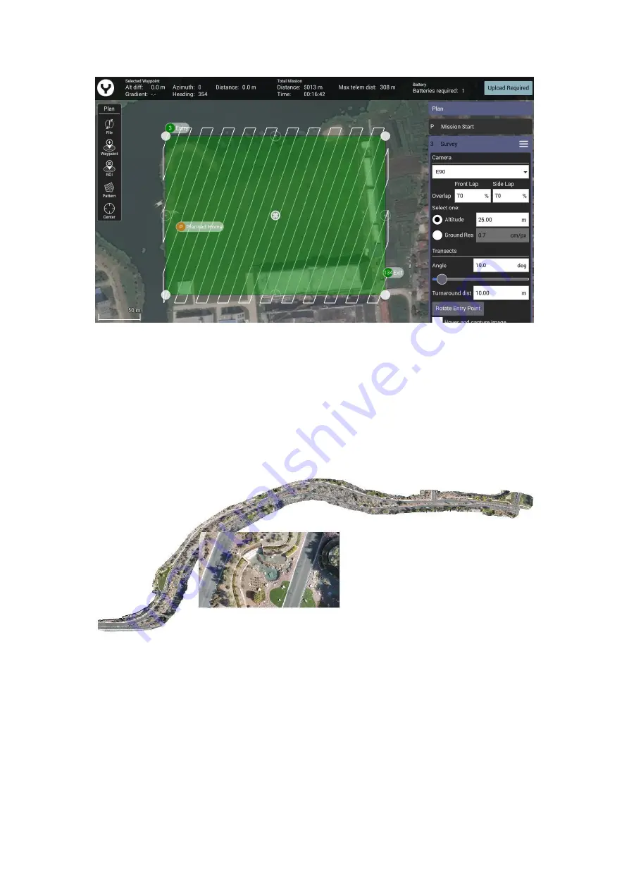
Roadways, power lines, train tracks, footpaths, and other narrow winding areas may be set up as 
“corridor scans.” Corridor scans enable the drone to fly long pathways with overlap for these 
sorts of missions


This is an example of a corridor scan


To create the CORRIDOR SCAN, tap the “Pattern” soft key, and select CORRIDOR SCAN.


Содержание H520E

Страница 1: ...H520E H520E RTK OVERVIEW H520E H520E RTK 01 Propeller 02 LED Status Indicator 03 Battery Chamber 04 OFDM Module 05 Retractable Lander Gear 06 OFDM Antennas 07 RKT Antennas H520E RTK only RTK...

Страница 2: ...Roll Control Mode 2 and Mode 1 13 Start Stop Video Recording Button 13 Start Stop Video Recording Button 14 Power Switch 15 2 4GHz Antenna 16 5GHz Antenna 17 Proportional Control Rate Slider 18 Gimbal...

Страница 3: ...hey show weakness Notice Voltage for a long time storage shall be 14 4V 15 6V range Full charged storage is prohibited Charge the ST16E battery Charge the ST16E battery by using supplied USB cable and...

Страница 4: ...tate propellers in the direction the points to until the propellers locked Cross check to be sure propellers are properly locked in place Installing the RTK Antenna H520E RTK only Screw the Antenna on...

Страница 5: ...Flight quick control panel 14 Camera quick setting Panel 15 Gimbal attitude indicator 16 zoom indicator 17 Map Video Switch 18 Flight Parameter Display 19 Camera Type 20 Photo Video Mode Switch 21 Shu...

Страница 6: ...on Tap the System setting button then Select the RC Calibration Item Then tap the Start Calibration button RC Mode Tap the System setting button then Select the RC Mode Item Select the Joysticks mode...

Страница 7: ...Locked Mark aligns with the front of the damping plate to secure the gimbal Step 3 Remove the lens protector Disassembling Step 1 Hold the gimbal release button and rotate the Gimbal Yaw Motor clockw...

Страница 8: ...or DNG format or simultaneous capture of both formats Video may be recorded in UHD 2K or HD resolutions at a variety of frame rates When the Gimbal was connected successfully the gimbal type will be...

Страница 9: ...l 30x zoom drone camera and makes it easy to zoom in on distant objects to gain valuable details The compact camera housing contains a 1 2 8 CMOS sensor which provides high quality and stabilized reco...

Страница 10: ...ideo Using the UHS 3 card allows the camera buffer to record to the micro SD card faster resulting in fewer buffers overrun Per Flight Preparation Environment Requirements Always operate the Drone in...

Страница 11: ...before powering on the UAS OFDM Module Re bind The aircraft and ST16E Ground Station are already bound out of factory There is no need to bind them Pilot can follow the steps below if rebinding is nee...

Страница 12: ...go on the top right corner again Step 5 Power on the drone until see the dialog box shown below Step 6 After initialization completes Use a paperclip or something like a needle to push the bind button...

Страница 13: ...Step 7 Tap the Next button on the ST16E screen Step 8 Waiting for connect finished...

Страница 14: ...long the specific axis which shown by the LED under the Motor Arm until a tone is heard and the display turns green Repeat this procedure for all six positions If Compass calibration fails ensure ther...

Страница 15: ...During Calibration Calibration Finished Download the Map In order to download the map the ST16E need to be connected to the internet via Wi Fi Tap the Wi Fi mark then select a hotspot...

Страница 16: ...ower left corner of the screen RTK data binding For H520E RTK only Option 1 CORS Network Binding Notice Please download the map first then connect the ST16E to the RTK data link Step 1 After the ST16E...

Страница 17: ...3 Fill the following NTRIP Stream Settings parameters according to your CORS Network Notice You must fill out the Required Tagging Form Step 4 Tap Apply to finish the connection process Notice When co...

Страница 18: ...ss and hold the START STOP button for about 3 seconds to start the motors in angle mode Slowly raise the left hand stick to take off OPTION 2 Tap the Take Off and slide on the screen to take off There...

Страница 19: ...used when transiting broad areas RTL MODE When in RTL Mode the drone will return to the home point and automatically lower the retractable gear to land MANUAL MODE When in Manual Mode GPS will be dea...

Страница 20: ...tton then select the Vehicle item tap the Indoor Mode button Step2 Tick the Enable Indoor Flight Step 3 Push the Flight Mode Selection Switch to the Manual Flight Mode then press and hold the START ST...

Страница 21: ...gimbal pan mode switch on ST16E When the switch position is up the gimbal camera is in Follow Mode The pan control of the gimbal camera is now disabled The gimbal camera will adjust its pan direction...

Страница 22: ...point A waypoint defines a specific location and behavior at a specific point in time allowing for intelligent auto functions during flight Waypoint flight is ideal for capturing oblique images perime...

Страница 23: ...To set the Planed Home Position Parameters and the behavior when mission was finished or other global settings of the mission please open the Mission Start Setting Panel Which above all the Waypoint...

Страница 24: ...nel and select Survey function This will place a green survey grid in the middle of the screen over the map To move the survey grid around the map hold and drag the white dot in the center of the surv...

Страница 25: ...el up and down to view more items CORRIDOR SCANS Roadways power lines train tracks footpaths and other narrow winding areas may be set up as corridor scans Corridor scans enable the drone to fly long...

Страница 26: ...oad as seen in the image on the previous page The aircraft will fly the white lines detailed in the pathway In this image seven vertices have been inserted allowing the Drone to follow the curvature o...

Страница 27: ...or output las files to products such as Revit or Autodesk workflows Structure scans may also be used for virtually any vertical scan element and may be combined with other automated flight profiles S...

Страница 28: ...the vertices to create a new vertex This allows for complex shapes such as the one seen above Update Save the Flight Mission No matter what kind of the flight mission function you are using after the...

Страница 29: ...on In the condition of GPS Locked in Angel Flight Mode after the flight path has been uploaded to the drone tap the Main Interface button to switch back then slide the slider The drone will execute th...

Страница 30: ...SC4000 4E Recharge Time 2 hours 2 hours Hovering Accuracy Horizon 1 5m Vertical 0 5m Horizon 1 5m Vertical 0 5m DGPS RMS Accuracy N A Horizon 0 4m Vertical 0 8m RTK RMS Accuracy N A 1cm 1ppm H 1 5cm 1...

Страница 31: ...ry caused by damaged spare parts or not using original Yuneec spare parts Damage and or injury caused by unauthorized change settings and or parameters Damage and or injury caused by modify and or add...

Страница 32: ...to our service center for repair and maintenance service or any other service We may also collect other information such as device information server log information etc We may also collect personal i...

Страница 33: ...erials to observe it for at least 15 minutes Continuing to charge or discharge a battery that has begun to balloon or swell can result in a _re A battery that has ballooned or swollen even a small amo...

Страница 34: ...ed by a radio signal subject to interference from many sources outside your control Interference can cause momentary loss of control To ensure proper and safe operation of the automatic landing functi...

Страница 35: ...used in accordance with the instructions may cause harmful interference to radio communications However there is no guarantee that interference will not occur in a particular installation If this equi...

Страница 36: ...appareildoit accepter tout brouillageradio lectriquesubi m mesi le brouillageest susceptible d encompromettre le fonctionnement This equipment complies with IC RSS 102 radiation exposure limit set for...

Страница 37: ...pport Https yuneec kayako com This content subject to change downloads the latest version from www yuneec com If you have any questions about this document please contact us by Start a conversation on...

Отзывы: