background image

Voxtrack 500 Navigation Software User Guide

Page 20 of 59

3.7

Save to Favorites

When selecting a Destination which you may use regularly,
you can save it to your personalized

Favorites

list.

1. 

At the map screen, press the

 button to open the

Destination menu.

2. 

Select and specify your desired destination as
described previously, be it from

Address, POI,

History

 or

Contacts

.

3. 

To save the location in your

Favorites

 folder, click the

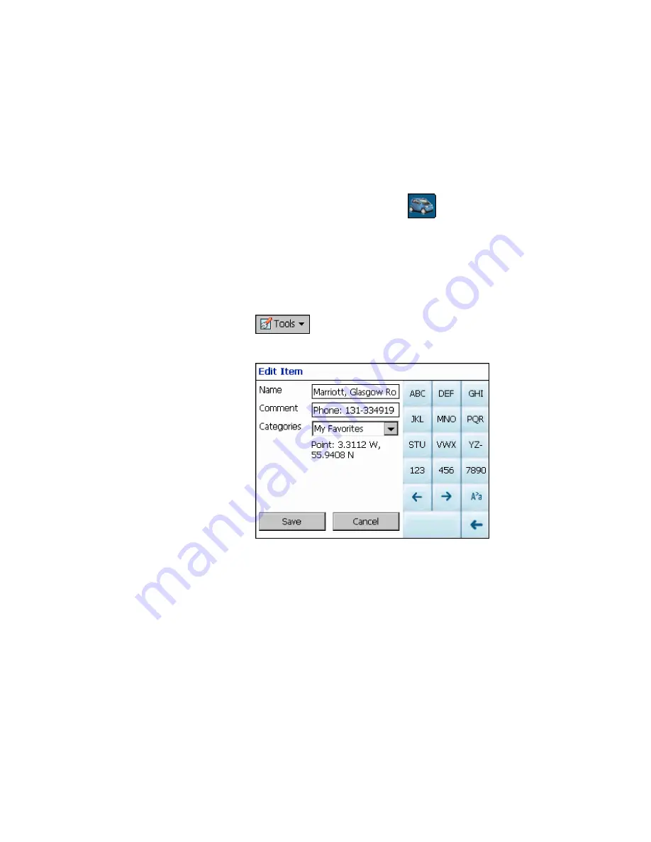
 button and select Favorites. The Edit Item

Properties screen is displayed.

          Figure 6 - Adding An Item to Favorites

4. 

Enter a name and comment that will help you
recognize the item in future.

5. 

Enter a new category name (eg: Must see) or select
an existing one and press

Save

.

Your favorite destination has now been stored for future use.

Содержание Voxtrack 500

Страница 1: ......

Страница 2: ...event shall Destinator Technologies be liable to Client and Client hereby waives any indirect special incidental or consequential damages in connection with the transactions contemplated by this agreement whether or not such damages were foreseen or their likelihood disclosed Destinator Technologies shall not be liable to Client or any third party claiming through Client for any damages of any kin...

Страница 3: ...Navigate To A Favorite 19 3 7 Save to Favorites 20 3 8 Navigate To A History Item 21 3 9 Navigate To A Point on the Map 22 3 10 Trip Planning 23 3 11 Avoid Roads 26 Chapter 4 Options 28 4 1 Introduction 28 4 2 The Options Menu 29 4 3 Show Route 29 4 4 Driving Directions 29 4 5 Turn By Turn 31 4 6 Cancel Route 31 4 7 Play 31 4 8 Switch Maps 32 4 9 Travel Mode 32 4 10 Help 32 4 11 About 33 Chapter 5...

Страница 4: ...48 7 2 Configuring Auto Alerts Category 49 7 3 Configuring Auto Alerts Items 49 7 4 Favorites Alerts 50 Chapter 8 Glossary 51 Chapter 9 Appendix A Device Settings 53 Chapter 10 Index 57 Note The content of this document constantly changes to reflect the latest changes in procedures screens buttons icons general improvements and updates to the Destinator software hardware and maps ...

Страница 5: ...urn Dialog 31 Figure 15 GPS Status Screen 35 Figure 16 GPS Settings Dialog 36 Figure 17 Home Button Settings Screen 37 Figure 18 General Settings Dialog 38 Figure 19 Map Settings Dialog 38 Figure 20 Route Settings Screen 40 Figure 21 Alert Settings Dialog 41 Figure 22 Visual Notifications Screen 42 Figure 23 Look Feel Screen 43 Figure 24 Main Map Screen 45 Figure 25 2D Night View 46 Figure 26 3D V...

Страница 6: ...ion system It utilizes GPS Global Positioning System satellites to pinpoint your location utilizing the latest mapping data technology to get you to your destination in the most efficient and timely manner The Destinator software assists you in planning your route and it provides Turn by Turn Voice and Visual instructions for getting to your destination ...

Страница 7: ...at you turn around and go back to the original route Rather Destinator will calculate a new route to your destination using your current position 1 3 Getting Help An abbreviated Help file with basic Destinator navigational definitions and instructions is available At the map screen press the button cycle to the Options Menu and select 1 4 Technical Support If you have other questions please contac...

Страница 8: ... location to install the device DO NOT INSTALL the device in any place that could Obstruct the driver s view of the road Interfere with vehicle controls or safety devices Cause injury to the driver or passengers Interfere with the safe deployment of the airbags SECURE the device to the dashboard to prevent it from injuring driver or passengers in the event of a sudden vehicle movement or collision...

Страница 9: ...e car holder on the windscreen in such a way that you can see the navigation screen without difficulty and so that it does not hinder a clear view of the road 3 Lock the suction cup in place 4 Use the supplied charging cable as required to connect the device to the vehicle s power supply in order to recharge the battery during the journey Note The GPS may take a few minutes to find its current loc...

Страница 10: ... You will be able to select a destination set your origin or plan a journey The route calculated in real time is from your current GPS position There are several ways to configure your destination using the Menu button You can navigate to An Address An Intersection A Zip Postal Code A POI Point Of Interest An Address in Favorites An Address In History ...

Страница 11: ...u Button Current Location Battery Status Indicator Home Button Length Scale Indicator Figure 1 Main Map View Location Icons or in Pedestrian Mode shows your current location while in Navigation Mode or in Pedestrian Mode shows your last known GPS location while in Navigation Mode This is not your current location because there is no valid GPS information at this time or in Pedestrian Mode shows th...

Страница 12: ...ng either or In Pedestrian Mode the navigation radius is restricted to 10 kilometres 6 miles Displays details about your route such as ETA Estimated Time of Arrival ETR Estimated Time Remaining and the distance to your destination Displays GPS generated information such as altitude longitude coordinates geographic position current location altitude and speed The icon indicates the next item to be ...

Страница 13: ...edestrian Mode You can toggle between these two modes by holding down this button for several seconds In Pedestrian Mode the navigation radius is restricted to 10 kilometres 6 miles Pressing the button allows you to cycle to the Destination Menu the Options Menu and the Settings Menu as seen in Figure 2 Figure 2 Menu Structure ...

Страница 14: ...ination menu 2 You can choose your destination from the following options Address list Point of Interest POI list Favorites list History list 3 From your current position the route is calculated and displayed as a blue line The green triangle represents your Origin or departure point Current location Route Figure 3 Main Map View Dialog ...

Страница 15: ...ture becomes available only when you have several maps installed The default order for entering your destination is City Street Number but by clicking on the button you can cycle through the different ways of specifying your address Click on this button to change your search type Figure 4 Address Search Screen Lets you search for an address by first entering the City then the Street then the Numbe...

Страница 16: ...s of the city name The scroll list will update accordingly You can also change your keyboard from uppercase to lowercase by pressing the button 3 Press Street to display a list of street names for the selected city Select the street name by entering the first few characters or by scrolling down the list eg Birch Ave 4 Not all cities towns are mapped to the street level In such cases the software w...

Страница 17: ...y street name and latitude and longitude coordinates Note Some smaller sub municipalities may not contain street data In such cases please choose the larger super municipality displayed in parentheses to search for these streets Alternatively you can change the search order to Street City or Zip Postal Code Street to find street data for the smaller municipality 3 5 Navigate To A Point of Interest...

Страница 18: ...on 3 Press Categories and highlight your selection from the list of POI categories For example we can search for the nearest restaurant Figure 5 POI Categories At this point you can display all the items within a category on the map screen by tapping the button beside any of the categories When selected the button will appear as Press to return to the map screen 4 With Restaurants highlighted tap ...

Страница 19: ... Favorites list A Favorite is an address or destination previously stored by you for quick and easy retrieval You can also save edit or delete destinations from this folder 1 From the Destination menu press the Favorites button Your list of Favorites categories is displayed 2 Highlight My Favorites and tap Items A list of stored items is displayed 3 Highlight your selection and click to calculate ...

Страница 20: ... your desired destination as described previously be it from Address POI History or Contacts 3 To save the location in your Favorites folder click the button and select Favorites The Edit Item Properties screen is displayed Figure 6 Adding An Item to Favorites 4 Enter a name and comment that will help you recognize the item in future 5 Enter a new category name eg Must see or select an existing on...

Страница 21: ...o the top of the list the older destinations at the bottom are erased Figure 7 History List 1 From the Destination Menu press the History button to display your list of previously traveled routes 2 Highlight your selected History item and click to calculate your route The route is shown on the map as a blue line from your current GPS position 3 You can also select to preview your destination on th...

Страница 22: ...nt and then tap the desired location 2 A dialog box displays the address of that point and lets you select whether you want to navigate to it recalculate your route add the point to your Favorites or set it as your Origin if you are in Planner Mode 3 To clear the cursor dialog just tap the screen again If you need to reset the point of Origin tap the map screen to open the Cursor Dialog and select...

Страница 23: ...n stages from the departure point to the first waypoint Once you ve reached the first waypoint the route is recalculated to the second waypoint and then recalculated to the third waypoint and so on How to Use Trip Planning Use the following method to plan a trip 1 Ensure you are in Planner Mode To do this press the button and cycle to the Settings Menu 2 Press Route Settings and select Planner mod...

Страница 24: ...our trip folder e g My trip and press Save You can now enter the waypoints of your trip What is a waypoint A waypoint is a stop or break in your journey along a predefined route 7 Highlight your trip folder and press Waypoints near the top of the screen to define your waypoints 8 From the tool bar at the bottom click Tools and select Add to define your waypoints 9 Select the address of your first ...

Страница 25: ...route are shown in a series of single line vectors 12 Using or you can change the order of your waypoints to suit your purposes 13 You can also click on Tools Optimize which will automatically sort the waypoints for the most effective and quickest route 14 To calculate the route press Navigate The route is shown as a blue line from your current GPS position Remember to change back to Navigational ...

Страница 26: ...he Avoid Roads button to display a list of road categories Figure 11 Avoid Roads Categories 2 To place restrictions on a desired road category highlight the category and press or to suit your preference Press to add a new category 3 Tap on Items to list all the roads in a highlighted category To specify restrictions for a particular road highlight it and press or To preview a highlighted road on t...

Страница 27: ...Voxtrack 500 Navigation Software User Guide Page 27 of 59 Figure 12 Avoid Roads Items 4 Once you have specified your road restrictions press to return to the map screen ...

Страница 28: ...Introduction There are various route and map options available from the Options Menu This chapter contains the following topics Showing your Route Displaying Directions Canceling your Route Recording and Playing Back a Route Switching Maps Selecting Travel Mode Getting Help ...

Страница 29: ...our route on the map screen in its entirety plus details such as the address of and distance to your destination the ETA and the ETR 4 4 Driving Directions This function displays a visual list of your route distances to each manoeuvre and street names By using the scroll bar on the right hand side you can scroll through the entire route Tapping on the manoeuvre twice displays that part of the rout...

Страница 30: ... as the address of your destination the ETA and the ETR Cancel Route Cancels and clears the route from the map screen Show Turn Displays the highlighted portion of the list on the map screen including the street name distance to it and an arrow diagram to indicate the turn You can also use the Prev and Next arrows to scroll to the previous or next turn Avoid Turn Will recalculate your route to exc...

Страница 31: ...ts are displayed at varying intervals to indicate your next turn or change of direction Figure 14 Turn by Turn Dialog 4 6 Cancel Route Cancels and clears the route from the map screen 4 7 Play This feature allows you to record your route as you re traveling and then to play it back on the map screen at a later time From the Play Record screen you can record a route play back a route change the spe...

Страница 32: ...d version numbers of your maps and allows you to delete maps 4 9 Travel Mode You can further define your route according to whether you are traveling by car or on foot This button lets you switch to Pedestrian Mode or Vehicle Mode In Pedestrian Mode the navigation radius is restricted to 10 kilometres 6 miles 4 10 Help This button launches an abbreviated help file with basic navigational definitio...

Страница 33: ...Voxtrack 500 Navigation Software User Guide Page 33 of 59 4 11 About Displays software version and details about your Destinator application ...

Страница 34: ...tion You can easily change the default settings of maps views and route parameters to suit your personal preferences This chapter contains the following topics GPS Status Home Button Settings General Settings Map Settings Route Settings Alert Settings Visual Notifications Look Feel ...

Страница 35: ...ses GPS signals to pinpoint your location In Navigation mode the software automatically acquires GPS signals and constantly updates your vehicle s location and position The GPS may take a few minutes to find its current location initially For best results ensure that the GPS has a clear view of the sky Figure 15 GPS Status Screen To view your GPS configuration click on the button You can access th...

Страница 36: ...S Settings Dialog GPS Settings Configuration menu 1 COM Port Defines the Communications Port 2 Baud Rate Transmission rate of data 3 Protocol Default is NMEA Find GPS Searches for and locates the GPS signal Set GPS Sets the GPS Configuration Press the button to save your selections and return to the GPS Satellite graphic screen ...

Страница 37: ...he nearest gas station press the button In the Home Button Settings screen select either POI Mode or Address Mode to set your desired destination Figure 17 Home Button Settings Screen Press the button to save and return to the map screen Now when you press the button Destinator will automatically calculate a route to this destination 5 5 General Settings The General Settings screen allows you to c...

Страница 38: ...ic units 1 Imperial Miles and yards 2 Metric Kilometers and meters Press the button to save your selection and return to the map screen 5 6 Map Settings The Map Settings screen lets you customize your map display Figure 19 Map Settings Dialog Map Orientation Forward is up orients the map so that your forward direction is always at the top ...

Страница 39: ...s always at the top Zoom Mechanism Automatic Zoom ensures that the zoom will return to its previous level after several seconds of inactivity Map Font Use large labels increases the size of street names to make the map easier to read Press the button to save your selections and return to the map screen ...

Страница 40: ...ur current position As you drive your location is compared to the destination you have chosen and you will be constantly provided with accurate driving directions Even if you accidentally drive off course Destinator will direct you back on track Planner Mode Displays a route on the map You set an origin and a destination and Destinator displays a map that shows you the route In this mode of operat...

Страница 41: ... the route will be calculated by including any U Turns that are needed If you clear this option the route will be calculated without any U Turns This feature is included because some drivers prefer not to make U Turns Note Route generation excludes any detours stops or delays along the route Press the button to save your selections and return to the map screen 5 8 Alert Settings This screen displa...

Страница 42: ...pdates ETA and distances 3 Low Signal Warns that you are in an area of low GPS signal 4 GPS Not Found Alerts you if the GPS signal is lost or if power is removed from the GPS receiver 5 Drive Carefully Friendly reminder at the start of each journey Press the button to save your selections and return to the map screen 5 9 Visual Notifications The Visual Notifications screen lets you choose how Dest...

Страница 43: ...ne No visual prompts are displayed Press the button to save your selections and return to the map screen 5 10 Look Feel The Look Feel screen allows you to customize the sound and appearance of Destinator Figure 23 Look Feel Screen Voice Prompts Default or change to different voice Skin Default skin or different skins if available Press the button to save your selections and return to the map scree...

Страница 44: ... of 59 6 Changing Map Views 6 1 Introduction You can change your view of the map and the way in which the map is displayed on the screen This chapter contains a description of the following topics How to Zoom and Scroll Types of Views Day or Night Mode ...

Страница 45: ...Settings button you can use the zoom buttons to override the auto zoom but the zoom will return to its previous level after several seconds of inactivity When Automatic Zoom is not selected you can zoom in or zoom out manually and it will remain at that level You can scroll the map by holding your stylus on the screen and dragging the image in any direction ...

Страница 46: ...nsional view This is the default map view In this view the map is dynamically updated and allows for manual panning and zooming 2D Night View This is a high contrast two dimensional view optimized for night driving or adverse weather conditions The map is dynamically updated and allows for manual panning and zooming Figure 25 2D Night View The route start point and destination outlined in blue are...

Страница 47: ...basic 3D relief It shows the basic relief outline and details of the surrounding roads and general area Figure 26 3D View 3D Night View The 3D night view is a simplified three dimensional view with high contrast colorization optimized for night driving or adverse weather conditions Figure 27 3D Night View Current location Current location ...

Страница 48: ...alert you when you are within a certain distance of the item s location You can configure two distances for each Automatic Alert Destinator will first alert you when you are within the first distance and then alert you when you are within the second distance Automatic Alerts must be stored in either one of three predefined categories Auto Alerts 1 Auto Alerts 2 and Favorites Alerts ...

Страница 49: ...hen the distance between your current traveling position and the location of the alert equals the distance you enter here 5 Close the Edit menu 6 To display the map position of items in the Auto Alerts category check the box to the left of the category name just as you would to display map positions of items in any other category 7 Select Save to complete the configuration 7 3 Configuring Auto Ale...

Страница 50: ... You cannot change any other information Note that if you change the category the item will be moved out of the current category Only those items found in either Auto Alerts 1 or Auto Alerts 2 will actually function as auto alerts 5 Close the edit window 7 4 Favorites Alerts From the Favorites folder you can add a new Category called Favorites Alerts These alerts function the same way as Auto Aler...

Страница 51: ...tours stops or delays along the route ETR Estimated Time Remaining The estimated time remaining to complete the route Does not allow for any delays FAQ Frequently Asked Questions A list of Frequently Asked Questions with Answers GPS Global Positioning System The GPS Global Positioning System is a constellation of 24 well spaced satellites that orbit the Earth and make it possible for Vehicles peop...

Страница 52: ...s the earth Eg a GPS Satellite which orbits the earth in a fix pattern height and speed SD Secure Digital memory card A Secure Digital SD card is a tiny flash memory card used to make data storage portable among various devices TTD Total Time Duration The projected total time the trip is calculated to take does not allow for any detours or other delays ...

Страница 53: ...pressing SETTINGS on the main screen Figure 29 Settings Menu for Device Opens the Settings Menu for your device Power Settings See Figure 31 Language Settings See Figure 34 System Information See Figure 35 Time Settings See Figure 33 Backlight Settings See Figure 32 Returns you to the Main Screen Volume Setting See Figure 30 Opens the navigation software Destinator ...

Страница 54: ...30 Volume Setting Screen The Volume Setting screen lets you adjust the volume of the device Press to return to the Settings menu Power Settings Figure 31 Power Settings Screen The Power Settings screen indicates the battery status of the device Press to return to the Settings menu ...

Страница 55: ... lets you select how bright the screen will be You can save power by selecting how long the backlight will stay on before it dims Press to return to the Settings menu Time Settings Figure 33 Time Settings Screen The Time Settings screen allows you to select your time zone and lets you set the date and time Press to return to the Settings menu ...

Страница 56: ...uage that will be used for screen displays and voice prompts Press to return to the Settings menu System Information Figure 35 System Information Screen The System Information screen displays the software version of your Destinator application and information about your device You can also calibrate the position of the display Press to return to the Settings menu ...

Страница 57: ...Check 36 Current Position Icon 11 Not Found 42 Ports 36 Protocol 36 Settings 35 Signal 42 Status 35 H Help 7 History 21 I Icons See Button Descriptions Index 57 K Known Address 14 M Map 46 Information 39 Settings 39 N Navigation Mode Origin Icon 14 New Origin 22 O Origin 14 Planner Mode 40 P POI 17 22 Point Of Interest 17 Point On the Map 22 Prompt Voice 29 Q Quickest route 41 R Recalculation of R...

Страница 58: ...oom 45 Route generation 41 S Save Favorites 20 Set New Origin 22 Settings Alert 41 General 38 GPS 35 Map Orientation 38 Route 40 Units 38 Shortest route 41 Speed 42 Start Point 22 Street Find 16 Name 16 T Trip 23 Trip Planning 23 V View 2D 46 3D 47 Changing Map View 44 Types 46 Z Zoom 45 Automatic 39 ...

Страница 59: ...www voxson com ...

Отзывы: