background image

Page 69

How Do I Use It?

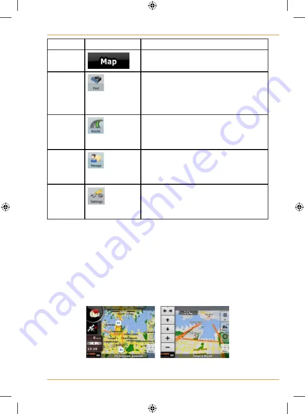
Screen

Button

Description

Map

The Map screen.

Find

Selecting the destination (for example 

an address or a POI) or using the search 

engine of TRAX353 for any other reason 

(for example to look for the phone 

number of a POI).

Route

Managing the active route (obtaining 

information about it, changing or deleting 

it or parts of it) or planning a route 

without GPS reception.

Manage

Managing user data, such as saved 

locations (POIs, Favourites, Pins, and 

History items), Saved Routes, and Track 

Logs.

Settings

Managing the behaviour of TRAX353, 

for example the map layout during 

navigation, the used languages or the 

warnings.

Map screen

TRAX353 is primarily intended for land navigation. That is why maps in 

TRAX353 look similar to paper road maps. However, TRAX353 provides 

much more than regular paper maps: you can customise the look and the 

content of the map.
The most important and most often used screen of TRAX353 is the Map 

screen.


During navigation, the screen shows route information and trip data (left 

Содержание TRAX353

Страница 1: ...TRAX353 In Car Navigation OWNER S MANUAL ...

Страница 2: ...ormation 14 2 Getting started with TRAX353 14 Start using TRAX353 16 Simple and Advanced modes 17 Hardware button Power on off 19 Buttons and other controls on the screen 19 Using keyboards 21 Using the map 22 Checking the details of a map location 22 Manipulating the map 23 Status information and hidden controls on the map 27 Using the cursor the selected map location 33 TRAX353 Concepts 34 Smart...

Страница 3: ...g the destination of a route 45 Selecting the Cursor as the destination 46 Entering an address or part of an address 46 Entering an address Australia 46 Entering an address if house numbering is restarted 48 Entering an address without knowing the district suburb 50 Selecting an intersection as the destination 52 Selecting a city centre as the destination 53 Entering an address with a postal code ...

Страница 4: ...h creating a Track Log 66 Simulating a Track Log on the map 67 Changing the colour of a Track Log 67 Saving a route 67 Loading a saved route 68 4 Reference book Advanced mode 68 Map screen 69 Icons on the map 73 Battery GPS position quality and Vehicle type indicator 73 Status indicator strip 75 Next two route events Turn Preview fields 76 Objects on the map 77 Streets and roads 77 3D object types...

Страница 5: ...Managed Saved Search Criteria 99 User Data management 100 Settings Menu 101 Map Screen settings 102 Sound settings 103 Route Planning options 104 Regional settings 106 Navigation settings 107 Warning settings 109 GPS settings 110 Menu settings 111 Device settings 111 Track Log settings 112 5 Bluetooth 114 6 Glossary 126 Warranty 130 ...

Страница 6: ...ee seconds to turn the device completely off Windshield mount If you do put the device on your windshield don t forget to lock it up or take it with you when you leave your car USB port for software and map updates Power connection Power button Notch for windshield mount bracket Suction latch Bracket bottom Suction cup pull tab Bracket top Suction cup Adjustment lock Power Button Notch for windshi...

Страница 7: ...ming in the device turns itself on and charges the battery As soon as the power stops for example when you unplug the adapter or turn off your car the device automatically shuts down If you want it to stay on tap anywhere on the screen during the Shutting down message You can turn the device on or off anytime you want just push the power button on top of the device hold the button for three second...

Страница 8: ... the road for a few minutes It s a good idea to take valuable items with you when you leave you car that includes GPS devices If you can t take the device with you lock it in the glove compartment or hide it somewhere And don t forget to take down the windshield mount you don t want to remind any potential thieves that you might have some valuable mobile electronics in the car Don t leave the devi...

Страница 9: ...Do I Put It in My Car Attaching the windshield mount Insert the bracket hooks into the notches on the bottom of the device 1 and snap the top hook into the notch on top of the device Rotate the bracket head up 3 2 ...

Страница 10: ... up down right and left any just about angle in between Angle the suction cup and the bracket where you want them then push the adjustment lock back down to lock the windshield mount into position If the bracket still moves too easily after you push the adjustment lock down tighten the bracket joint lift the adjustment lock and twist the lock handle clockwise two maybe three turns The bracket pivo...

Страница 11: ...to place Gently pull on the mount to 3 make sure it is secure If you have trouble getting the suction cup to stick Clean the spot with an ammonia free cleanser Dry the spot completely use a lint free cloth if possible Make sure the spot is smooth and flat suction cups won t stick well on a curved or textured surface Removing the windshield mount When you release the suction latch make sure you re ...

Страница 12: ...he device s weight The surface should be as smooth as possible If the surface texture is too rough the glue may not stick as well The anchor disk will stick permanently on most surfaces If you try to remove the disk you might damage the surface Don t peel off the protective sheet until you re ready to install the disk Once you expose the glue you can t stop easily When you decide where you want to...

Страница 13: ...e 5 edges too so that every part of the disk makes good contact with the surface Before you install the windshield mount gently tug on the disk to make 6 sure it s secure 7 Remove the clear plastic sheet from the top of the anchor disk Press the suction cup flat against the 8 anchor disk then push the suction latch down towards the suction cup to lock it into place Flip the latch down towards the ...

Страница 14: ...the route TRAX353 has a Safety Mode if you turn on Safety Mode you cannot change anything in TRAX353 while the vehicle is moving at a speed of 10 km h 6 mph or higher Unless only passengers operate TRAX353 we strongly encourage you to turn on Safety Mode You must obey the traffic signs and follow the road geometry If you deviate from the route that TRAX353 recommended TRAX353 changes the instructi...

Страница 15: ...he buttons on the Map screen you can set or reset the zoom value of the button 2D map Tap and hold any of the buttons on the Map screen you can set or reset the tilt and zoom values of the button 3D map Tap and hold on list and menu screens the Navigation menu appears Tap and hold any of the buttons on the Map screen you can rotate tilt or scale the map continuously Tap and hold on keyboard screen...

Страница 16: ...on any screen Start using TRAX353 When TRAX353 is started the first time you need to do the following 1 Select the written language of the application 2 Select the language and speaker used for voice guidance messages IMPORTANT To use the Spoken Street Names feature you must choose a guidance language which is enabled for Text To Speech These are indicated with TTS 3 Select whether to start the pr...

Страница 17: ... 60 Use a saved location a Favourite page 57 a POI page 57 the History of previously set destinations and waypoints page 59 Simple and Advanced modes The two operating modes of TRAX353 mainly differ in the menu structure and the number of available features The controls and screen layouts are the same Simple mode you have easy access to the most important navigation functions and the basic setting...

Страница 18: ...es See page 57 Navigating to a POI Yes Yes See page 57 Navigating to coordinates No Yes See page 60 Creating a multi point route No Yes See page 61 Saving a map point as a Favourite destination Yes Yes See page 81 Saving a map point as a POI No Yes See page 81 Saving a map point as a location of a Road Safety Camera No Yes See page 81 Mark a map point with a Pin No Yes See page 81 Saving the activ...

Страница 19: ... off TRAX353 does not calculate your GPS position and it does not update the route or the driving instructions When you turn the device on again TRAX353 continues navigating as soon as the GPS receiver has determined your position Buttons and other controls on the screen When you are using TRAX353 you usually tap buttons on the touch screen You only need to confirm selections or changes in TRAX353...

Страница 20: ...al different unnamed values TRAX353 shows an indicator on a gauge that displays and sets a value from a range Drag the handle to move the slider to its new position Tap the slider where you want the handle to appear the thumb jumps there Switch When there are only two choices a checkmark shows whether the feature is enabled Tap it to turn the switch on or off Virtual keyboard Alphabetic and alphan...

Страница 21: ...lect from the list of available keyboard types TRAX353 remembers your last keyboard choice and offers it the next time you need to enter data Correcting your entry on the keyboard Remove the unneeded character s tap Tap and hold the button to delete the entire input string Entering a space for example between a first name and a family name or in multi word street names Tap Entering small or capita...

Страница 22: ...sition during navigation 1 Check the bottom line of the map It shows the current street and house number information 2 For further details tap to open the Position menu 3 Tap The address the coordinate and the list of nearby POIs will be displayed You can check the details of any other location by selecting it on the map 1 Tap the map anywhere to open the map control buttons 2 Tap the desired loca...

Страница 23: ...ition page 34 Selected location Cursor page 35 The following controls help you modify the map view to best suit your actual needs Most of these controls appear only if you tap the map once and disappear after a few seconds of inactivity Action Button s Description Moving the map with drag drop No buttons You can move the map into any direction tap and hold the map and move your finger to the direc...

Страница 24: ...ton Smart Zoom button Zooming in and out Changes how much of the map is displayed on the screen TRAX353 uses high quality vector maps that let you see the map at various zoom levels always with optimised content It always displays street names and other text with the same font size never upside down and you only see the streets and objects that you need Map scaling has different limits in 2D and i...

Страница 25: ... can turn away from Track Up with these buttons If GPS position is available and you have rotated the map the button appears Tap this button to re enable the automatic map rotation Viewing modes Gives you the following map perspectives in TRAX353 classic top down view 2D perspective view 3D The value always shows the mode the button switches to If you are in 2D mode you can see the button and you ...

Страница 26: ...able Smart Zoom Tap hold the button to set the zoom limits of Smart Zoom Returning to normal navigation back to the GPS position with automatic map rotation Tap this button to move the map back to the current GPS position If the map has been rotated in 3D mode automatic map rotation is also re enabled Zoom preset buttons available in Advanced mode only Tap one of the preset buttons to set the zoom...

Страница 27: ... screen It is available on the following screens Plan on Map screen When you have an active route you can display it in its full length on the map Track Information screen A track log can be displayed in its full length on the map Status information and hidden controls on the map The following information appears in the rounded field in the top left corner the Turn Preview field When tapping this ...

Страница 28: ...nd an active route are available but automatic off route recalculation is switched off and you deviated from the route Tap this area to make TRAX353 recalculate the recommended route If the icon is animated route calculation is in progress TRAX353 is calculating or recalculating the route Nothing happens if you tap this area of the screen Next route event next manoeuvre GPS position and an active ...

Страница 29: ...d an active route are both available this field shows the route event that follows the next route event shown in the above described area Tap this area to open the Itinerary screen with the turn by turn guidance instructions Approaching a Road Safety Camera This icon appears when you are approaching a Road Safety Camera and the warning for cameras is enabled in Settings Tap this area to suppress t...

Страница 30: ...f the screen The following symbols appear in the Indicator strip Icon Description The sound output of TRAX353 is muted The sound output of TRAX353 is enabled TRAX353 records a Track log when GPS position is available Track log recording is disabled The Bluetooth radio is switched off The Bluetooth radio is turned on but no telephone is connected ...

Страница 31: ...no active route these fields show the following information current speed compass and the current time of day Icon Type More Information Compass Shows the direction of your heading both when the map is automatically rotated 3D and when the map is always facing North 2D Speed information There are speed values that can be shown Current speed Speed limit on the current road Time information There ar...

Страница 32: ...ber of lit bars represent the remaining capacity The battery is being charged The device is running on external power The battery is being charged Vehicle type The symbol displays the vehicle type used for route calculation Using the Cursor the selected map location First place the Cursor at the desired map location with one of the following options Use the Find menu to select a location The map r...

Страница 33: ...e one that suits your needs the best available in Advanced mode only Saves the Cursor as a POI available in Advanced mode only Saves the Cursor as a Favourite location Saves the Cursor as a Road Safety Camera location available in Advanced mode only Marks the map with a Pin at the Cursor available in Advanced mode only Opens a screen with the name address and coordinate information of the Cursor a...

Страница 34: ... GPS position is available TRAX353 marks your current position with the icon on the map The exact location of the position marker depends on the vehicle type used for route calculation The vehicle type can be selected in Route settings page 93 or in the Quick Menu page 89 If you choose pedestrian The icon is at your exact GPS position The direction of the icon shows your actual heading If you choo...

Страница 35: ... according to your current GPS position Selected location Cursor If you select a location in the Find menu or you tap the map when the map control buttons are visible the Cursor appears at the selected point on the map TRAX353 displays the Cursor with a radiating red dot to make it visible at all zoom levels even when it is in the background of a 3D map view When the Cursor is set tap The Cursor m...

Страница 36: ...s are similar to paper road maps The night colour schemes use dark colours for large objects to keep the average brightness of the screen low TRAX353 offers different daytime and night colour schemes It can also switch automatically between the daytime and the night scheme based on the current time and GPS position a few minutes before sunrise when the sky has already turned bright and a few minut...

Страница 37: ...t Short Economical Easy Vehicle types Car Taxi Bus Emergency vehicles Bicycle Pedestrian Road types Unpaved Roads Permit Needed Motorways Toll Roads Charge Roads Ferries Cross border Planning TRAX353 automatically recalculates the route if you deviate from the proposed itinerary For further information about Route Planning options see page 104 ...

Страница 38: ...ayed for example In Advanced mode tap the following buttons You have the following options on the Itinerary screen Button Description Any of the list items Opens the map with the selected manoeuvre in the middle Changes the detail level of the Itinerary The levels are as follows Detailed Instructions all intersections are listed Itinerary only significant intersections the ones announced in voice ...

Страница 39: ...be recorded renamed replayed shown on the map exported to the internal Flash ROM in GPX format and deleted See page 66 Independently of the normal track log you can instruct TRAX353 to record the native GPS data received from the GPS device These logs are saved as separate text files on the internal Flash ROM and they cannot be shown or replayed in TRAX353 To turn on NMEA SIRF log saving tap the f...

Страница 40: ...sparent they do not cover the streets and intersections behind them POIs are grouped into several levels of categories and subcategories The icon of a POI that comes with the map shows the symbol of the POI category If you save your own POI you can select an icon for it independently of the POI category you have put it in Saving POI To save a POI place the Cursor at the desired location then tap t...

Страница 41: ...Camera place the Cursor at the desired location then tap the following buttons Camera warning The warning for Road Safety Cameras can be turned on in Warning Settings Tap the following buttons When you approach a Road Safety Camera with the warning enabled the following happens Visible Warning The type of the camera is displayed in the secondary Turn Preview field for example Audible Warning If th...

Страница 42: ...you can specify the controlled traffic direction and the speed limit TRAX353 warns you when you approach these speed cameras in the measured direction If your speed exceeds the speed limit near the speed camera TRAX353 plays a special warning sound Mobile Some speed cameras are operated from vehicles They do not always work and they are not set to check a preset speed limit The warning is similar ...

Страница 43: ...d camera types In the rare case TRAX353 cannot register the moment you pass the second speed camera for example it is placed at the exit of a tunnel where GPS position is not yet available the warning continues Just tap the speed camera symbol displayed on the screen to stop the warning Red light These cameras check if you obey traffic lights The warning is similar to mobile speed cameras as there...

Страница 44: ...s contain information about the speed limits of the road segments This information may not be available for your region ask your local dealer or may not be fully correct for all roads on the map You can configure TRAX353 to warn you if you exceed the current limit Tap the following buttons When you exceed the speed limit the following happens Visible Warning A symbol with the speed limit appears i...

Страница 45: ...X353 offers you several ways of choosing your destination and via points intermediate destinations Use the selected location on the map the Cursor page 46 Enter a full address or a part of an address for example a street name without a house number or the names of two intersecting streets page 46 Enter an address with postal code page 55 This way you do not need to select the name of the settlemen...

Страница 46: ...later when the Cursor menu appears save it as a POI or put it on the list of your Favourites first The Cursor menu returns automatically with the same point Now you can use it as a route point Entering an address or part of an address If you know at least a part of the address it is the quickest way to select the destination of the route Using the same screen you can find an address by entering th...

Страница 47: ...untry you also need to select the state or tap to search for a settlement regardless of the state it is in 3 If you have not changed the country you still have the possibility to change the state Tap the button with the name of the state and select from the list 4 If needed change the settlement To select the settlement from the list of recently used ones tap the button To enter a new settlement 1...

Страница 48: ...open the list of results before it appears automatically 4 Pick the street from the list 6 Enter the house number 1 Tap 2 Enter the house number on the keyboard 3 Tap to finish entering the address 7 The map appears with the selected point in the middle Tap Simple mode or Advanced mode from the Cursor menu The route is then automatically calculated and you can start navigating Entering an address ...

Страница 49: ...t a different one from the list 3 If needed change the settlement To select the settlement from the list of recently used ones tap the button To enter a new settlement 1 Tap the button with the name of the settlement or if you have changed the country state tap 2 Start entering the settlement name on the keyboard 3 Get to the list of search results After entering a couple of characters the names t...

Страница 50: ...ap Simple mode or Advanced mode from the Cursor menu The route is then automatically calculated and you can start navigating Entering an address without knowing the district suburb Long roads can run across several districts or suburbs You may not know if a particular house number is in which of them In this case follow the instructions below The procedure is explained starting from the Navigation...

Страница 51: ...tering a couple of characters the names that match the string appear in a list Tap to open the list of results before it appears automatically 4 Pick the settlement from the list 4 Enter the street name 1 Tap 2 Start entering the street name on the keyboard 3 Get to the list of results After entering a couple of characters the names that match the string appear in a list Tap to open the list of re...

Страница 52: ...e mode or Advanced mode 2 By default TRAX353 proposes the country state and settlement where you are If needed tap the button with the name of the country state and select a different one from the list 3 If needed change the settlement To select the settlement from the list of recently used ones tap the button To enter a new settlement 1 Tap the button with the name of the settlement or if you hav...

Страница 53: ...keyboard screen appears Start entering the name of the intersecting street on the keyboard As you type if the matching streets can be shown on one screen their list appears automatically 6 Tap the desired intersecting street in the list 7 The map appears with the selected point in the middle Tap Simple mode or Advanced mode from the Cursor menu The route is then automatically calculated and you ca...

Страница 54: ...nes tap the button To enter a new settlement 1 Tap the button with the name of the settlement or if you have changed the country state tap 2 Start entering the settlement name on the keyboard 3 Get to the list of search results After entering a couple of characters the names that match the string appear in a list Tap to open the list of results before it appears automatically 4 Pick the settlement...

Страница 55: ...untry state and settlement where you are If needed tap the button with the name of the country state and select a different one from the list 3 Tap the button with the name of the settlement and enter the postal code 1 Start entering the postal code on the keyboard 2 Get to the list of results After entering a couple of numbers the ones that are a match appear in a list Tap to open the list of res...

Страница 56: ...ring the settlement name or the street name tap the button after a couple of letters TRAX353 lists the items that contain the character set You can speed up finding an intersection Search first for the street with a less common or less usual name fewer letters are enough to find it If one of the streets is shorter search for that one first You can then find the second one faster You can search for...

Страница 57: ...nced mode from the Cursor menu The route is then automatically calculated and you can start navigating Selecting the destination from the POIs You can select your destination from the POIs included with TRAX353 or from the ones you have previously created The procedure is explained starting from the Navigation menu 1 Tap the following buttons Simple mode or Advanced mode 2 Select the area around w...

Страница 58: ...on and after that if needed select the POI subgroup e g Hotel or Motel To find the POI by its name tap and use the keyboard to enter a part of the name To list all POIs in a given POI group tap 4 optional When finally the list of results appear you can sort the list sort the list alphabetically available when you search around a single location sort the list by the distance from your current posit...

Страница 59: ...you can use instantly when searching for a POI The procedure is explained starting from the Navigation menu 1 Tap the following buttons Simple mode or Advanced mode 2 Tap 3 Select one of the saved criteria and the list of matching POIs appear 4 Tap the desired POI in the list 5 The map appears with the selected point in the middle Tap Simple mode or Advanced mode from the Cursor menu The route is ...

Страница 60: ...tering its coordinate This feature is available in Advanced mode only The procedure is explained starting from the Navigation menu 1 Tap the following buttons 2 optional Tap to change the format of the displayed coordinates 3 Tap the latitude or longitude value to change the coordinate 4 Enter the coordinate values in WGS84 format on the keyboard the latitude N or S and the longitude E or W 5 Tap ...

Страница 61: ... as you like If you insert a via point in a route that is already a multi point route you will automatically be taken to the Edit Route screen where you can determine the position of the intermediate route point When you enter the screen the new via point is placed as the last via point before the final destination The new point is the selected point in the list You have the following options Butt...

Страница 62: ...w destination The previous destination becomes the last via point of the route This feature is available in Advanced mode only 1 Select a new location as you did in the previous sections This will be the additional destination in the route 2 The map appears with the selected point in the middle and the Cursor menu opens automatically 3 Tap to open the full Cursor menu with the additional functions...

Страница 63: ...inal destination of the route The route is reversed The start point becomes the destination the destination becomes the start point and all via points are to be reached in the opposite order than before The route is optimised The start point and the destination remain at their position but the via points are reordered to make the shortest possible route The selected point is removed from the route...

Страница 64: ...g buttons 2 The Route menu appears There are two ways of running the route simulation Tap to run the simulation at high speed to give you a quick overview of the route Tap to run the simulation at normal speed and with voice guidance instructions announced This option is for demonstration purposes or for checking difficult parts of the route in advance 3 The simulation can be aborted any time by t...

Страница 65: ...driving again TRAX353 restarts the voice instructions from your position Deleting the next via point from the route The easiest way to delete the upcoming route point the next via point in Advanced mode is to open the Route Information screen by tapping the Turn Preview field on the Map screen and then tapping In Advanced mode you have another option Tap the following buttons Deleting the active r...

Страница 66: ...position changed that you drive You do not need to select a destination and create a route for this you can also record your driving path while cruising This feature is available in Advanced mode only The procedure is explained starting from the Map screen Recording the travelled path creating a Track Log 1 Start driving 2 Tap the following buttons 3 Start the recording tap the button You return t...

Страница 67: ...returns and the Track Log simulation a life like replay begins 4 You can stop the replay any time by tapping the button Changing the colour of a Track Log 1 Tap the following buttons 2 Tap the desired Track Log and then tap one of the colour buttons Saving a route This feature is available in Advanced mode only The procedure is explained starting from the Map screen 1 Tap the following buttons 2 E...

Страница 68: ... the very likely case when the start position of the saved route is different from the current GPS position you need to confirm whether you want to stop navigating from the current GPS position to use the start point of the loaded route If you choose this option the automatic off route recalculation will be disabled If you choose to keep the current GPS position as the start point the route will b...

Страница 69: ...ser data such as saved locations POIs Favourites Pins and History items Saved Routes and Track Logs Settings Managing the behaviour of TRAX353 for example the map layout during navigation the used languages or the warnings Map screen TRAX353 is primarily intended for land navigation That is why maps in TRAX353 look similar to paper road maps However TRAX353 provides much more than regular paper ma...

Страница 70: ...Opens the Itinerary Trip data Opens the Trip Information screen Battery status Opens the Quick menu GPS position quality Opens the Quick menu Vehicle used in route calculation Opens the Quick menu Top row Next street n a Bottom row Current street and house numbers on left and right n a Map view modes Switches between 2D and 3D map modes Menu Opens the Navigation menu Detour Opens the Detour screen...

Страница 71: ...e left right 3D map only Tilt up down 3D map only Zoom preset buttons 2D map only Tilt and zoom preset buttons 3D map only Return to GPS position button Smart Zoom button Rotate left rotate right Rotates the 3D map left or right Tilt up tilt down Tilts the 3D map Zoom in zoom out Scales the map Return to GPS position appears when GPS position is available and you have moved the map Tap this button...

Страница 72: ...vailable in 2D mode Tap hold any of the buttons to set its value to the current zoom level or to reset it to its original value Tilt preset buttons available in Advanced mode only Tap one of the preset buttons to set the tilt and zoom levels to fix predefined values Smart Zoom is disabled These buttons are available in 3D mode Tap hold any of the buttons to set its value to the current tilt and zo...

Страница 73: ...oth connection and communication status Battery GPS position quality and Vehicle type indicator This is a complex indicator and a button that opens the Quick menu The battery part shows information about the rechargeable battery of the device Icon Description The battery is charging The device runs on external power The battery is not charging but it is full The battery is not full but it still ha...

Страница 74: ...s too weak and the receiver cannot determine the GPS position GPS navigation is not possible Only a few satellites are received Position information is available but elevation altitude cannot be calculated GPS navigation is possible but the position error may be significant Altitude information is available the position is a 3D position GPS navigation is possible The remaining part of the field sh...

Страница 75: ...The sound output of TRAX353 is enabled TRAX353 records a Track log when GPS position is available Track log recording is disabled The Bluetooth radio is switched off The Bluetooth radio is turned on but no telephone is connected There is an error in the Bluetooth connection TRAX353 is connected to a telephone as a handsfree set via Bluetooth A phone call is in progress over the Bluetooth connectio...

Страница 76: ...S position and the lower manoeuvre shows the distance between the next point and the final destination or 3rd position Most of these icons are very intuitive and you also know them as road signs The following table lists some of the frequently shown route events The same symbols are used in both fields Icon Description Turn left Turn right Turn back Bear right Turn sharp left Keep left Continue st...

Страница 77: ...hat is similar to how the paper road maps show them Their width and colours correspond to their importance you can easily tell a motorway from a small street If you prefer not to see street names during navigation turn them off page 102 3D object types To enable or disable 3D visualisation on the map tap the following buttons TRAX353 supports the following 3D object types Icon Description Elevated...

Страница 78: ...d cities and countries Building Visibility Feature unavailable This switch is presented for future expansion and currently performs no action Elements of the active route TRAX353 shows the route in the following way Symbol Name Description Current GPS position Your current position displayed on the map In pedestrian mode it is the exact GPS position If a vehicle is selected for route calculation t...

Страница 79: ...e turned off to keep the selected point as the start point If the automatic off route recalculation is disabled for any of the above tapping the icon in the Turn Preview field not only initiates a route recalculation from the current GPS position but it will re enable the automatic off route recalculation as well Via point A via point is an intermediate destination You can place as many via points...

Страница 80: ...04 However when TRAX353 cannot avoid such roads the route will include them and it will show them in a colour that is different from the route colour Detour menu This screen contains quick detour possibilities during navigation It can be opened directly from the Map screen by tapping You have the following options On the main part of the screen you can see the first page of Saved Search Criteria S...

Страница 81: ...e previous screen Zooms out the map Zooms in the map With the Cursor menu open you can still move or scale the map and tap the map anywhere to place the Cursor to a new location but when you use this button the Cursor jumps back to the place where it was at the time when you opened the Cursor menu Displayed at the Cursor if it is at the same location with which the Cursor menu was opened Displayed...

Страница 82: ...he new destination The previous destination is demoted and becomes the last via point This button is similar to the button but a new screen opens and the route is calculated with all the possible route calculation methods Fast Short Economical and Easy Observe the results and choose one of the routes to navigate The Cursor becomes the start point of the route This means that the route will not be ...

Страница 83: ...d opens a new screen where you can edit the details of the camera The location of the Cursor is added to the list of frequently visited destinations the so called Favourites You can give a name for the Favourite Position menu When you follow the recommended route on the map the Cursor is the current GPS position the Position menu replaces the Cursor menu It does not contain buttons that modify the...

Страница 84: ...leftmost point is the start of the route the rightmost one is the final destination and you can see your via point flags along the line spaced in proportion to their distance Tap this field to change the content of all data fields to via point information Arrival Estimated Arrival Shows the estimated arrival time at the final destination of the route based on information available for the remainin...

Страница 85: ... Fast Short Easy or Economical will be displayed here if you have selected Emergency Bicycle or Pedestrian this information will be displayed here Tap this field to change the content of all data fields to via point information Warning icons In these square fields graphical symbol are displayed in case warnings are attached to the planned route These are warnings so icons always show information f...

Страница 86: ...pen the screen all route data fields contain information about reaching your final destination Tap and the fields concerning your route display data for the next via point Tap the button repeatedly to toggle between the two possibilities You have the following data and functions on this screen Name Description Function or Shows whether the route data fields show information about the final destina...

Страница 87: ...unt traffic jams and other possible delays Tap this field to show it on the map screen in one of the Trip Data fields Arrival Time Shows the estimated arrival time at the final destination of the route based on information available for the remaining segments of the route The calculation cannot take into account traffic jams and other possible delays Tap this field to show it on the map screen in ...

Страница 88: ...bout the final destination again Most of the fields on this screen have a symbol next to them This symbol shows whether the field it is attached to is shown on the map as a Trip Data It also shows the position of the data as follows Symbol Description This value is not shown on the map screen This value appears on the map screen in the Trip Data area This is the value at the top This value appears...

Страница 89: ...esume collecting trip data Resets all counters of the currently shown trip Collecting trip data is restarted only when TRAX353 receives a position from the GPS Cycles through all trips Quick menu The Quick menu is a selection of controls that are frequently needed during navigation It can be opened directly from the Map screen by tapping If you tap any of the switches in the Quick menu except for ...

Страница 90: ...hemes the other colour scheme returns at the next scheduled time Opens Colour Profiles settings Not used Opens 3D Settings Tap this button and select the Vehicle type to be used for route calculation Otherwise it is selected in Route Planning options in Settings page 104 Changing the Vehicle type triggers an automatic route recalculation Opens Route Planning options Turns track log recording on or...

Страница 91: ... the GPS reception Icon Colour Name Description Green TRAX353 has a connection to the GPS receiver and GPS position information is available in 3D TRAX353 can calculate both your horizontal and vertical GPS position Yellow TRAX353 has a connection to the GPS receiver and GPS position information is available in 2D only the horizontal position is calculated TRAX353 cannot calculate your vertical GP...

Страница 92: ... connection Red blinking TRAX353 has no connection to the GPS receiver and does not try to establish a connection n a Sky view circle The virtual sky shows the visible part of the sky above you with your position as the centre The satellites are shown at their current positions The GPS receives data from both the green and yellow satellites Signals from the yellow satellites are only received whil...

Страница 93: ...u can select your destination from the thousands of POIs included with TRAX353 or from the ones you have previously created Page 57 The destinations that you have already entered in TRAX353 are available in the History list Page 59 You can select your destination by entering its coordinates Page 60 You can select as your destination a location that you have already saved as a Favourite Page 57 Ope...

Страница 94: ... you need the same route you will have to rebuild it from scratch Page 65 You can save the active route for later use Page 67 You can load a previously saved route for navigation Page 68 Opens the Route settings screen with controls to modify the vehicle the road types used for route calculation or the route calculation method Page 101 You can run a demonstration of the route at high speed Page 39...

Страница 95: ...isibility settings Page 97 Creating renaming or deleting Saved Search Criteria Page 99 Manage Saved Routes You can manage the previously saved routes Tap the following buttons Button Description Button with the name of the saved route Opens the selected route for editing Deletes the selected route Clears the list of saved routes Turns the page for additional list items Manage History You can manag...

Страница 96: ...rt recording a track log in the Quick menu Stops the ongoing Track Log recording You can also stop the track log recording in the Quick menu Button with the name of the track log Shows the details of the selected Track Log Starts a simulated playback of the selected Track Log on the map Turns the page for additional list items When track log details are shown Button Description Button with the nam...

Страница 97: ...nserted memory card in GPX format Manage Favourites You can manage the list of your Favourites Tap the following buttons Button Description Button with the name of the Favourite Opens the selected Favourite for editing Deletes the selected item in the list of Favourites Clears the list of Favourites Turns the page for additional list items Manage POIs You can manage your POIs and set the POI visib...

Страница 98: ... Tap to see all POIs in the list Creates a new POI group at the given group level Turns the page for additional list items This POI group is not shown on the map This POI group and all its subgroups are shown on the map This POI group and some of its subgroups are shown on the map This POI group contains POIs that you saved When a POI group is open for editing Button Description Items in the POI g...

Страница 99: ...p this button to select a new icon for the POI Tap this button to enter a telephone number for the POI Tap this button to enter additional information for the POI Tap this button to delete the selected POI Tap this button to move the POI to another POI group or subgroup Manage Saved Search Criteria You can manage the list of search criteria previously saved to easily find frequently searched POI t...

Страница 100: ... using the button in the Cursor menu Tap this button to remove all your Pins from the map Backup User Data All user data and the current settings will be saved on the inserted memory card There is always one backup file If you perform a backup later the previous backup will be overwritten with the new information Restore User Data All user data and settings will be overwritten with the information...

Страница 101: ...ge 103 These settings determine how routes will be calculated Page 104 These settings allow you to adjust the application to your local language measurement units time and date and their formats as well as choose the voice guidance profile you prefer Page 106 You can control how TRAX353 behaves during navigation Page 107 You can enable some handy warnings and disable the touch screen in a moving v...

Страница 102: ...ns Button Description 3D Settings Use 3D settings to determine which of the present 3D objects are shown on the map and adjust the level of 3D visual detail The options are as follows Elevated Roads Complex intersections and vertically isolated roads such as overpasses or underground tunnels are displayed in 3D Terrain Detail Level 3D terrain map data shows changes in terrain elevations or depress...

Страница 103: ... reappear immediately Lane Information Some maps contain lane information to help you position your car in the upcoming intersection This setting tells TRAX353 whether to display this information at the top or at the bottom of the map Sound settings You can adjust the sounds of TRAX353 Tap the following buttons Button Description Master Volume Use the switch to mute all sounds of the device and th...

Страница 104: ...ictions may not be taken into account e g emergency vehicles have only a few restrictions Road Types Used for Route Planning To let the route fit your needs you can also set which road types are to be considered for or to be excluded from the route if possible Excluding a route is a preference It does not necessarily mean total prohibition If your destination can only be accessed using some of the...

Страница 105: ... roads are pay roads where you can purchase a pass or vignette to use the road for a longer period of time They can be enabled or disabled separately from toll roads Permit needed You might need a permit or permission from the owners to use certain roads or to enter certain areas TRAX353 excludes these roads from the route calculation by default Ferries TRAX353 includes ferries in a planned route ...

Страница 106: ...he motorway instead of series of smaller roads or streets Regional settings These settings allow you to adjust the application for your local language measurement units time and date and their formats as well as choose the voice guidance profile you prefer Tap the following buttons Type Description Program Language This button displays the current written language of TRAX353 By tapping the button ...

Страница 107: ...353 can also help you set the time zone based on your current GPS position Time and Time Zone Settings Type Description Auto Time Correction to GPS Use this feature to synchronise the clock of your device to the very accurate time provided by the GPS receiver Use Auto Time Zone Use this feature to synchronise the time zone of the clock of your device to the time zone based on your current GPS posi...

Страница 108: ...nded route Setting another point than the current GPS position as the start point of the active route will automatically disable this feature Restore Lock to Position If you have moved or rotated the map during navigation this feature moves the map back to your current GPS position and re enables automatic map rotation after the given period of inactivity Automatic Overview This feature switches t...

Страница 109: ...or your region ask your local dealer or may not be fully correct for all roads in the map This setting lets you decide whether you wish to receive the warnings You can set the relative speeding at which the application warns you 100 is the current speed limit In Built up Areas in cities and towns Elsewhere at all other locations There are two types of warnings You can turn them on or off independe...

Страница 110: ...ive fast You are asked if you want to change to car navigation mode This way you can be sure you will not be routed via one way roads in the wrong direction as a pedestrian could for example Safety Mode Safety Mode disables the touch screen above 10 km h 6 mph to keep your attention on the road While driving you will not be able to set a new destination or to change settings The only screen contro...

Страница 111: ...nimation You can activate and deactivate the Menu animations When animation is turned on buttons on Menu and keyboard screens appear in an animated way Background You can choose the image to be used as the menu background image Skin This feature is not available on the current software Device settings You can change some device settings to control the screen backlight when TRAX353 is running Tap t...

Страница 112: ...set the backlight level for daytime use Backlight at Night You can set the backlight level for night use Track Log settings You can set up an automatic Track Log saving and fine tune its settings Tap the following buttons Type Description Update Interval This is how often track points will be saved Position information is normally received once a second from the GPS If you do not need such a detai...

Страница 113: ...imit is reached the oldest automatically saved track logs will be deleted Create NMEA SIRF Log Independently of the normal track log you can instruct TRAX353 to record the native GPS data received from the GPS device These logs are saved as separate text files on the internal Flash ROM and they cannot be shown or replayed in TRAX353 ...

Страница 114: ...From the Map screen tap the following buttons The Bluetooth Phone Menu screen appears Phone Menu The Phone Menu screen is the main menu of the Bluetooth feature The following Phone Menu screen shows Bluetooth Off with no paired phone Bluetooth Off No Phone Pairing a Bluetooth Phone Your mobile phone needs to be paired or registered to TRAX353 to use the Bluetooth feature Touch and then touch Bluet...

Страница 115: ...TRAX353 will search for and list nearby Bluetooth devices No Paired Devices are currently listed Make sure the Bluetooth on your phone is enabled Touch to begin search Touch to search for Bluetooth devices Touch to select the desired Bluetooth device ...

Страница 116: ...ator automatically in the future See your phone manual for more details Pairing is finished Touch to exit the pairing procedure Touch to initiate connection with Bluetooth device About to connect to your phone for the first time If your phone requires you to specify a password enter 1234 ...

Страница 117: ...cted You may have multiple phones set up for connection with your TRAX353 Bluetooth Off Connected Below is the typical display when Bluetooth on your mobile is set to connect automatically Bluetooth On Connected Touch to turn BT on Touch to Connect to paired device Bluetooth mobile phone ...

Страница 118: ...hones using the List Screen If you have phones already paired to the TRAX353 but have none of them currently connected the following screen appears when you touch from the Main Menu This screen allows you to connect to a device add devices and remove devices Paired Devices Select Phone Touch to delete selected device from paired list ...

Страница 119: ... Call Phone Menu Talk Phone Menu Talk on Phone When a Bluetooth call is received the name and number is displayed Touch to end call Touch to cancel incoming call Touch to accept the call and begin talk Touch to talk on phone Touch to talk on phone ...

Страница 120: ...tooth Call from Dial Pad To make a Bluetooth call touch the following buttons from the Map screen Phone Menu Talk Phone Menu Talk 1 i Input phone number 2 Touch to call 1 ii Touch to delete digit 3 Touch to end call 2 ii Touch to mote call ...

Страница 121: ...Add to Phonebook Touch to open Phonebook list If the phonebook is empty tap to download phonebook from paired phone Phonebook Empty Dial from Phonebook Phonebook Downloaded Select Name Touch to add Phonebook from Mobile Phone Touch to scroll down the phonebook list ...

Страница 122: ...l Log Call Log Touch to open Call Log list If the call log is empty TRAX353 will download the call log from the paired phone Touch name to select If a name entry has multiple numbers then these will display Touch phone number to begin call Touch to sort the list by first name F or last name L ...

Страница 123: ...Page 123 How Do I Use It Answered Call Making Call Dialled Call Missed Call Touch to select call log The details of the selected logged call will display Touch to cancel call Touch to begin call ...

Страница 124: ...Page 124 How Do I Use It ...

Страница 125: ...Page 125 How Do I Use It ...

Страница 126: ...e settlement but an arbitrary point the map creators have chosen In towns and villages it is usually the most important intersection in larger cities it is an important intersection GPS accuracy Several factors have impact on the deviation between your real position and the one given by the GPS device For example signal delay in the ionosphere or reflecting objects near the GPS device have a diffe...

Страница 127: ...ation and the route is cut into different legs from one destination to the next Scheme TRAX353 comes with different colour schemes for the map for daytime or night use Schemes are custom graphic settings for the map and they can have different colours for streets blocks or surface waters in 2D and 3D modes and they display shades or shadows in different ways in 3D mode One daytime scheme and one n...

Страница 128: ...Page 128 Notes ...

Страница 129: ...Page 129 Notes ...

Страница 130: ...set out below WARRANTY DURATION This warranty to the original retail owner only shall terminate and be of no further effect ONE 1 year after the date of original retail sale This warranty will be deemed invalid if the product is A Damaged or not maintained as reasonable and necessary B Modified altered or used as part of any conversion kits subassemblies or any configurations not sold by Uniden C ...

Страница 131: ...is EXPRESS WARRANTY is in addition to and does not in any way affect your rights under the TRADE PRACTICES ACT 1974 Cth Australia or the CONSUMER GUARANTEES ACT New Zealand PROCEDURE FOR OBTAINING PERFORMANCE OR WARRANTY In the event that the product does not conform to this warranty the Product should be shipped or delivered freight pre paid with evidence of original purchase e g a copy of the sa...

Страница 132: ...Thank you for buying a Uniden product 2008 Uniden Australia Pty Limited Uniden New Zealand Ltd Printed in China USZZ01214ZZ 0 ...

Отзывы: