Using the External Computer Data Link
MicronNav System
0656-SOM-00001-07
114
© Tritech International Ltd.
7.2.4. Simrad HPR 300P
This 3rd party output string is taken from the Simrad HPR positioning system. The string has
48 characters and the format is ASCII fixed field with space separators. Leading 0’s (except
time) are space filled. X,Y,Z co-ordinate positions are relative values unless GPS is active in
which case the co-ordinate outputs become Easting, Northing and Depth respectively. For
values greater than 999.9, the decimal point is removed (e.g. 1001.1 is output as “1001”).
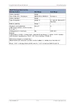
The full string format is as follows:
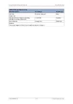
‘HPR 300P’ Reply Data Structure
Data Description
Data Range
Field Range
Beacon / Unit ID (0 = Responder, 1..15 =
Transponder, 19=INS)
0 to 19
ii
Transducer Number
Always 1
H
Beam
Always ‘W’
B
Status
‘ OK’ (No error)
or
‘NRY’ (No reply)
SSS
Compass heading (degrees)
0 to 359.9
ccc.c
X (or Easting)
0 to 999999
xxxx.x (or xxxxxx)
Y (or Northing)
0 to 999999
yyyy.y (or yyyyyy)
Z (or Depth)
0 to 999999
zzzz.z (or zzzzzz)
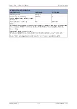
Quality Flag, unused
Always 0.0
QQ.Q
(Carriage Line Feed)
N/A
<CR><LF>
Example:
GPS is active so co-ordinates are World. Unit ID = 0 (Responder), Compass Heading = 119.5º, X
Co-ord (East) of 339080, Y Co-ord (North) of 497512, Z Co-ord (Depth) of 13.7m, No Error.
ASCII Output Always = “0**1**W***OK**119.5*339080*497512***13.7***0.0<CR><LF>”
Where; “*” is a space (ASCII code 32), “<CR>” is Carriage Return (ASCII code 13),“<LF>” is Line
Feed (ASCII code 10).


