background image

How-to-Guide

13

© 2005 ... TeleType GPS

3.4.1

Transfer Maps to PDA

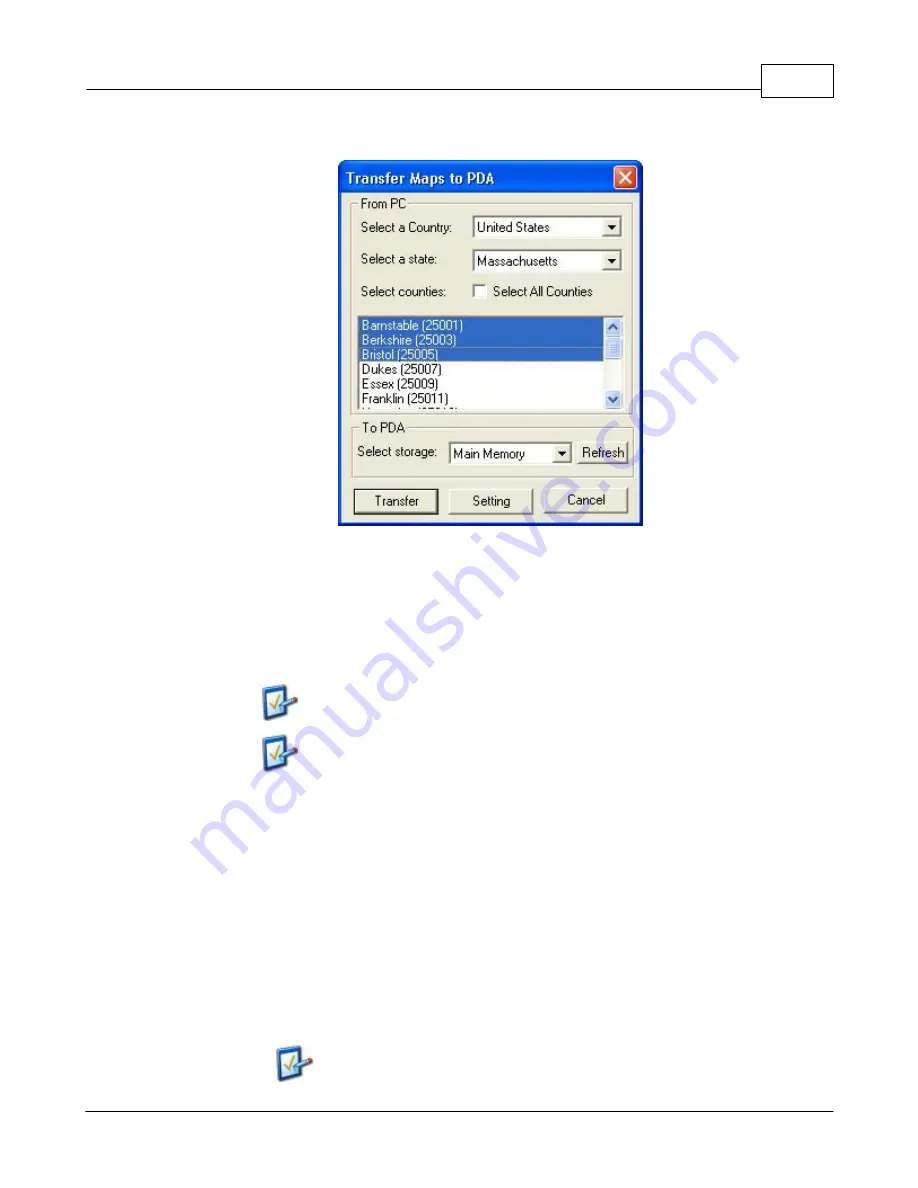
Transfer Maps window - Use this to export

street maps to either the main memory or

the storage card of your PDA.

This window will allow you to transfer the maps for all or part of a US state, Canadian province, and all
of a European country to the PDA. The 

Refresh

 button allows TeleType GPS software to recognize the

PDA if it was not synchronized before opening this window. 

The PDA must be in the cradle and synchronized with the PC
for software to recognize your PDA and for the maps to
transfer correctly. 
To copy an entire state, check the "select all counties" box
and click Transfer.


To transfer maps to the PDA, follow these steps:

1.

Select 

country

 from the country list.

2.

Select the state whose maps you want to transfer.

3.

Select the counties you wish to transfer, or tap or click on the box by 

Select All Counties

 to

highlight all of the maps for that state. 

4.

Select the 

Setting

 button to choose which types of maps (streets, highways, terrain or Yellow

Pages) you would like to transfer.

5.

Select where (Storage Card or Main Memory) you would like to store maps on the PDA. If you
have just inserted your memory card, use the 

Refresh

 button to view it in the "Select Storage"

menu.

6.

Select 

Transfer

 and wait for the maps to finish copying. If you selected a large number of

maps or a large state it can take a considerable amount of time to copy.

The Setting option will only be available when transferring
maps of the United States.

Содержание GPS Marine

Страница 1: ...2005 TeleType GPS Marine Manual Version 022005...

Страница 2: ...ly featured GPS enabled mapping software available for Windows CE and Pocket PC The same software also supports desktop and laptop systems TeleType offers a variety of software receiver combinations f...

Страница 3: ...e Charts 12 4 Exporting Marine Charts 13 Transfer Maps to PDA 14 Manage Maps 15 5 Changing Navigation 16 6 Loading Other Maps 18 7 Adding Deleting Waypoints 21 8 Planning a Trip 23 9 Loading a Trip 24...

Страница 4: ...Part I...

Страница 5: ...t all times and not become distracted by the GPS system to the exclusion of safe driving marine practices It is unsafe to operate the controls of the GPS system while you are driving or piloting Failu...

Страница 6: ...Street 2 You may create a route to an address similar to creating a Trip see Software Documentation 3 You can search for a hotel restaurant or address by selecting Tools Find and entering the appropr...

Страница 7: ...ich the PDA is connected to the PC through its cradle or cable Typically handled by the Microsoft ActiveSync software provided with your PDA The latest version of ActiveSync can also be downloaded fro...

Страница 8: ...Part II...

Страница 9: ...ne maps Steps 1 If you have not installed TeleType GPS Pro program please refer back to the TeleType GPS Pro program manual for instructions on installing the software If you installed TeleType GPS Pr...

Страница 10: ...Part III...

Страница 11: ...s of data scrolling through the center of your screen If you do not please make sure that your receiver is connected securely to your PDA the COM port is correct for your PDA and the baud rate is set...

Страница 12: ...at similar to this example US3AK8CM_mc ttm Now you have loaded the Marine Charts You will need to select what you want to see in the Marine Preferences For more information about setting the Marine Pr...

Страница 13: ...s To unload Marine Maps Unloading maps is the process of removing them from view these maps will remain on your computer for future use There are several ways to unload maps from view 1 To unload maps...

Страница 14: ...he street or aviation maps for an area will automatically be unloaded when you leave an area Note This feature is only available for street and aviation mode Manage Maps Window 3 4 Exporting Marine Ch...

Страница 15: ...r To transfer maps to the PDA follow these steps 1 Select country from the country list 2 Select the state whose maps you want to transfer 3 Select the counties you wish to transfer or tap or click on...

Страница 16: ...rectory of your choice on the PC They will be copied to the specified directory with the correct directory structure This is useful to organize your maps before a trip To export the maps directly to y...

Страница 17: ...ibed in greater detail in the Parameters section Marine Navigation will display Marine maps and view detailed information about locations of known ship wrecks buoys rocks underneath the ocean ferry ro...

Страница 18: ...particular location and selecting Load Unload from the shortcut menu Then you can choose exactly which type of maps to load or unload for a particular area 4 With the Auto Load feature enabled the sof...

Страница 19: ...parately from TeleType GPS On your laptop desktop draw a box around an area you wish to load using the left mouse button or stylus Once the box is drawn right click tap once on the PDA inside the box...

Страница 20: ...aded into the software If maps are being loaded from a storage card that storage card must remain in the PDA for the program to operate properly The basemap for a country will have to be loaded manual...

Страница 21: ...ts 1 During Street Navigation use the Find Address feature Once a list of addresses is found selecting the correct address and then clicking on Go To will create a waypoint at that address Only use th...

Страница 22: ...ter known location coordinates using the Clipboard icon in the Waypoints window Tools Waypoints The coordinates can be entered in either decimal degrees degrees decimal or degree minute second format...

Страница 23: ...eps 1 Load the appropriate Marine charts for your trip For instructions on loading Marine charts please see Loading Marine Charts 2 Follow the steps for Adding Creating Waypoints in the Adding Deletin...

Страница 24: ...w will appear prompting you to name your Trip After giving your Trip a name click on the Save button The extension for your Trip files are saved as nameGiven trp Your trp files are by default located...

Страница 25: ...any changes to this Trip you can refer to Editing a Trip section of this manual 3 9 Loading a Trip To Load a Trip Steps 1 Click on Marine at the menu and select Open Plan 2 A window will prompt you to...

Страница 26: ...he screen After the trip has been loaded you may need to zoom in or zoom out accordingly 3 10 Editing a Trip To Edit a Trip Steps 1 Make sure that the trip you want to edit is loaded If the appropriat...

Страница 27: ...t your Trip 4 After all the changes are made click Save to save those changes to the Trip file 3 11 Starting a Trip Starting a trip takes your current location requires lock in and compares it with al...

Страница 28: ...s allows you to familiarize yourself with the route and determine ahead of time how long it will take you You can run the simulator through various speeds and routes The Simulator is available for bot...

Страница 29: ...ing View Preferences Navigation Tools Preferences Navigation tab on the PDA and deselecting Head Up North up will also be enabled when the zoom scale is 5000ft or more Zoom In Zoom Out You can zoom in...

Страница 30: ...out your travels on a marine map select Tools Navigation Marine You should see an information area at the bottom of the map with details relating to speed distance location and other details important...

Страница 31: ...select the corner for which you wish to have certain information appear On the right drop down menu select the option for the type of information you want displayed Click Assign and the program will a...

Страница 32: ...Window see Set Marine Preferences To view instructions on how to change navigation and load marine maps see Loading Marine Maps section In order to use Marine Maps you must have purchased the Marine M...

Страница 33: ...them Selection Window with a list of symbols 3 Select the desired nautical object A toolbar will come up in the upper left corner of the screen and the nautical object that you have selected is highl...

Страница 34: ...in red 4 If you click or tap on the Details button a window will appear displaying the information about the symbol that you have selected Click or tap on OK to close the window 5 If you click or tap...

Страница 35: ...you can pick other symbols on the map in different areas 6 If you click or tap on the Close button the toolbar will go away and the green highlight will disappear If you try to find info on a symbol a...

Страница 36: ...Part IV...

Страница 37: ...igation Panel Ctrl F6 Display Air Navigation Panel Ctrl F7 Display Marine Navigation Panel Ctrl F8 Display No Navigation Panels Ctrl X Alt F4 Exit Program Ctrl F Find Address Alt N Find Nearest Airpor...

Страница 38: ...e between posistion and the destination waypoint BRG Shows bearing of the plane or boat relative to the North Pole XTK Cross track The perpendiculuar distance between the path of your current position...

Страница 39: ...GPS TeleType GPS Co 20 Park Plaza Suite 510 Boston MA 02116 Tel 617 542 6220 Fax 925 226 1558 info teletype com http www teletype com 42 3514 N 71 0694 W When contacting us please remember to give yo...

Отзывы: