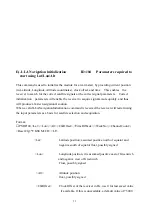

5
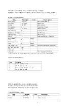
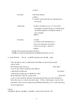
Table B-2 contains the values for the following example:
$GPGGA,161229.487,3723.2475,N,12158.3416,W,1,07,1.0,9.0,M,,,,0000*18
Table B-2 GGA Data Format
Name Example Units
Description
Message ID
$GPGGA
GGA protocol header
UTC Time
161229.487
hhmmss.sss
Latitude 3723.2475
ddmm.mmmm
N/S Indicator
N
N=north or S=south
Longitude
12158.3416
dddmm.mmmm
E/W Indicator
W
E=east or W=west
Position Fix Indicator 1
See Table B-3
Satellites Used
07
Range 0 to 12
HDOP 1.0
Horizontal
Dilution of Precision
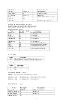
MSL Altitude
1
9.0
meters
Units
M
meters
Geoid Separation
1
meters
Units M
meters
Age of Diff. Corr.
second
Null fields when DGPS is not used
Diff. Ref. Station ID
0000
Checksum *18
<CR><LF>
End of message termination
1. SiRF Technology Inc. does not support geoid corrections. Values are WGS84 ellipsoid heights.
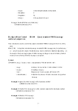
Table B-3 Position Fix Indicator
Value Description
0
Fix not available or invalid
1
GPS SPS Mode, fix valid
2
Differential GPS, SPS Mode , fix valid
3
GPS PPS Mode, fix valid
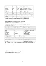
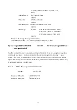
GLL-Geographic Position-Latitude/Longitude
Table B-4 contains the values for the following example:
$GPGLL,3723.2475,N,12158.3416,W,161229.487,A*2C
Table B-4 GLL Data Format
Name
Example Units
Description
Message ID
$GPGLL
GLL protocol header
Latitude 3723.2475
ddmm.mmmm


