28
10.
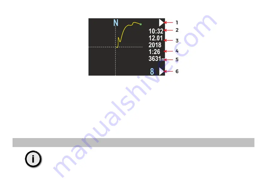
Swim route graph
This screen presents the changes in the diver location projected on a flat surface (like on a map). The route start point is
always positioned in the screen center. The route end point will be shown as a green dot, but only on the present route.
Near the right edge of the screen, you will find some information elements:
1 -
Top button role (now – go to next screen: return to main menu)
2 -
Time of first recorded data (hh:mm, 24-hour system)
3 -
Date of first recorded data (DD.MM / YYYY)
4 -
Total recording time, in minutes (above 2h, this value will be shown in hours), may be blank, if the value cannot
be calculated (empty record)
5 -
Total distance in meters (above 2000m in kilometers), may be blank, if the value cannot be calculated (empty
record)
6 -
Route number in memory (blue) and lower button role (now – go to the next route number)
Note
You may see small GPS symbol above the record time, if this route has also any valid GPS readings
recorded.
Содержание ENC II
Страница 1: ...1 ...
Страница 11: ...11 5 Main screen layout After power on the device display will show this content ...
Страница 69: ...69 ...
Страница 70: ...70 MARINE TECH SA 38 400 Krosno ul Żwirki i Wigury 1 7 POLAND info seacraft eu www seacraft eu ...


