background image


Settings 

Page 29/70 

May 2015 I 2.0 

4.2. Defining a new operation 

In order to perform an operation on a field that has 
been created, an operation must first be defined in 
SBGuidance. Operations are always linked to a 
particular field. Therefore, at least one operation 
must be defined for each individual field in order to 
use a field in SBGuidance.  

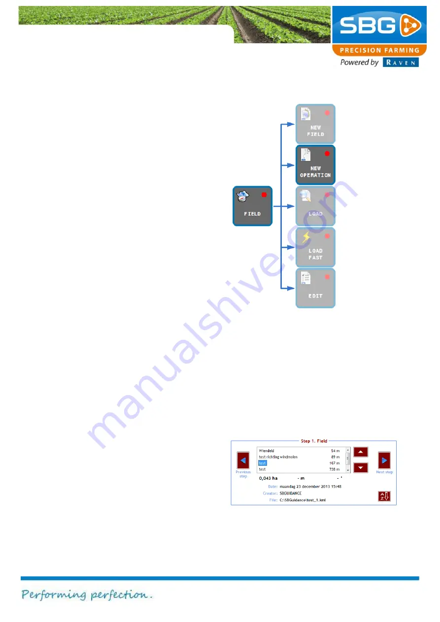
Figure 30 shows which keys should be tapped to 
add a new operation. In addition, SBGuidance 
proposes a new operation after a new field is 
saved.  

After tapping 

NEW OPERATION

the 

Operation


menu will be displayed at the bottom of the screen 
(Figure 31). 

This menu presents a summary of the five steps 
required to define an operation: 

1. 

Select the desired field. 

2. 

Select the desired reference line. 

3. 

Define the machine width. 

4. 

Define the operation offset. 

5. 

Define the headland turning point 
(optional). 

Select the field on which the operation has to be 
performed (Figure 31). The selection is highlighted 
in blue.  

Furthermore, detailed information concerning the 
selected field is displayed at the bottom of the 
screen. The distance between the current position 
and the field is displayed to the right of the field 
name. 

The alphabetical order of the list can be changed 
by tapping on 

A-Z

 at the bottom right of the 

screen. The options window enables operations to 
be sorted by date, name or distance. 


Figure 31 Defining a new operation


Figure 30 Defining a new operation


Содержание GeoStar 200

Страница 1: ...USER MANUAL ENGLISH SBGuidance 4 0 0 Software operation...

Страница 2: ...available for people who operate service and repair this product Name of device Type designation Serial no of manifold Serial no of terminal Serial no of sensor box Serial no of dynamIQ Year of manuf...

Страница 3: ...of the manual However SBG Precision Farming accepts no liability for any errors or incomplete information contained in this document Remarks or queries can be submitted to info sbg nl Neither SBG Prec...

Страница 4: ...rised persons to operate the system Authorised persons include Persons who have read and understood the operating manual and who are both physically and mentally fit to operate the system Caution Alwa...

Страница 5: ...13 2 System start up 15 2 1 Conditions of use 15 2 2 SBGuidance loader 16 3 Main menu 19 3 1 Soft keys 19 3 2 Information in the top menu bar 20 4 Fields 21 4 1 Creating a new field 21 4 1 1 A field 2...

Страница 6: ...fo 55 6 1 GPS info 55 6 1 1 Position 55 6 1 2 Orientation 57 6 2 Field info 59 6 2 1 Details 59 6 2 2 Work data 59 6 2 3 Edit operation 60 6 3 System info 60 6 3 1 Error messages 60 6 3 2 Version 61 6...

Страница 7: ...the main GPS antenna GPS1 4 WiFi antenna FNC 5 External audio 3 5 mm jackplug 6 USB 2x 7 Power 4 pin connector for 12V power 8 Main interface 20 pins connector for serial and CAN bus communication 9 E...

Страница 8: ...a 2 coax large N Connection of the second antenna GPS2 4 Main power switch 5 Screen dimmer 6 Ethernet 2 optional 4 pin connector 7 RS 232 17 pin serial connector for external devices 8 Ethernet 4 pin...

Страница 9: ...able 19 pin plug in screw connector for the sensor box 7 Ethernet 4 pin plug in screw connector for 12V power supply 8 CAN bus connection 8 pin connector 9 External modem 8 pin connector for an extern...

Страница 10: ...d hub connections are numbered 1 Power supply 2 UMTS antenna diversity see Figure 5 3 GPS antenna 4 UMTS antenna main see Figure 5 5 RS 232 COM port for serial communication sends RTK correction data...

Страница 11: ...see Figure 5 5 LED lights A description of the status information can be found on the top of the GeoConnect 3G modem 1 6 GPS antenna Figure 7 shows an installed GPS antenna 1 GPS antenna 2 UNC screw...

Страница 12: ...be shipped with a RAM C connection However for a Viper 4 terminal with an external GSM modem a RAM D connection is advised This type of fixture mount allows the position of the terminal to be adapted...

Страница 13: ...1 Mount the terminal with the RAM connection 2 Connect if present the CAN cable 3 Connect the data communication cable if present Press firmly and screw the connections tight 4 Connect the external p...

Страница 14: ...System start up Page 14 70 May 2015 2 0 Intentionally left blank...

Страница 15: ...read and accepted by the operator user The conditions of use can be accepted by tapping on I AGREE The language option for the conditions of use can be selected by tapping on the appropriate flag Chan...

Страница 16: ...ow or the name of the vehicle or device The device or implement selected is then highlighted in blue and displayed in the centre of the screen Press SBGUIDANCE beneath the options window after selecti...

Страница 17: ...the operating terminals or the SBGuidance Field Manager desktop software Machine manager This allows the tractor and implement settings selection keys to be exchanged between the operating terminals U...

Страница 18: ...System start up Page 18 70 May 2015 2 0 Intentionally left blank...

Страница 19: ...nic terrain compensation module will now be initialised 3 1 Soft keys Below is an overview of the keys available in the main menu soft keys Terminating the software Press and hold exit key for 3 secs...

Страница 20: ...correction message seconds 5 LED indicator bar displays the position with respect to the reference lines The scale of the LED s can be changed by touching the LED strip 6 Speed 7 Operating surface th...

Страница 21: ...use of this key 4 1 Creating a new field A field consists of one or more straight and or curved field boundaries or a complete contour Each field boundary has a starting point and a destination point...

Страница 22: ...atitude longitude and height Tip When defining the A point the vehicle must be stationary This makes it easier to precisely define where this point should be Point A is the position of the GPS antenna...

Страница 23: ...fields If you tap on NO the field will be saved with the name TEMPORARY FIELD The temporary field will be lost if you choose to create a new field and do not save the temporary field After the save o...

Страница 24: ...define one of the two points again In order to ensure that the AB line runs parallel to the edge of the field it is important that point A and point B have the same distance to the edge of the field...

Страница 25: ...at the field defined in this way is easier to find in the list of fields If you tap on NO the field will be saved with the name TEMPORARY FIELD The temporary field will be lost if you choose to create...

Страница 26: ...ur vehicle by tapping on Add corner point Corner point 1 is now defined This step must be repeated for a field that only has straight boundaries until all corner points are defined Tip Quite often it...

Страница 27: ...ection of an existing field boundary to be used as a reference line If the response to this question is YES a corner point will be created The curved and straight line sections are then defined as two...

Страница 28: ...t the field defined in this way is easier to find in the list of fields If you tap on NO the field will be saved with the name TEMPORARY FIELD The temporary field will be lost if you choose to create...

Страница 29: ...nu presents a summary of the five steps required to define an operation 1 Select the desired field 2 Select the desired reference line 3 Define the machine width 4 Define the operation offset 5 Define...

Страница 30: ...cannot be selected for defining an operation Please note If two straight lines at the opposite sides of the field run more or less parallel only one of the two lines can be selected for defining an o...

Страница 31: ...bsequent spraying operations The additional space to the left and or to the right of the spraying operation is entered using the two centre keys Entering a negative value reduces the spraying width Ti...

Страница 32: ...ys possible to change the headland distances again after they have been defined Tip Place a minus sign before the distance to position the headland line on the other side of the field boundary The ope...

Страница 33: ...now be loaded 4 4 Load fast After loading a field it is possible to switch fast between saved operations Tap on FIELD then on LOAD FAST Thereafter the OPERATION menu will be visible Tap on the arrows...

Страница 34: ...rking width and spray tracks the normal working width and spray working width can be edited Figure 39 Besides that it is possible to manually mark a track as a spray track which allows the user to mar...

Страница 35: ...g system of the tractor and or implement The different steering systems will be discussed in the following sections in more detail Tip The correct tuning parameters will depend on the field conditions...

Страница 36: ...cm tap on R Hydraulics Steering response speed Gain Sensitivity Standard Range Hydraulics 100 50 150 Gain 100 50 400 If the steering does not react quickly enough the hydraulic settings must be incre...

Страница 37: ...ired value Value 0 machine steers aggressive towards the active track for example to steer quickly on the line while leaving the headland Value 4 machine steers lazy towards the active track for examp...

Страница 38: ...implements Tap on the plus symbol in order to add a new front or rear mounted implement Tap on the red X symbol in order to delete the selected implement To open the Offsets menu of a tractor and fro...

Страница 39: ...before the set reference point When a negative value is entered at Offset OFF Figure 50 the headland signal will be outputted earlier while driving towards the headland from the field So the actual s...

Страница 40: ...to manually steer the Side Shift cylinder to the left or right Steer the cylinder completely to the left and then click on Left The same applies to the maximum adjustment to the right and the centre p...

Страница 41: ...actor is controlled less straight manually If the tractor drives relatively straight by itself and the device does not drift a smaller pulse length is required In the last step of the calibration wiza...

Страница 42: ...e main screen The Link disengage signals TWIN and the Link engage signals TWIN can be switched on in the OPTIONS tab Figure 58 The first option can be used to switch the implement steering off at the...

Страница 43: ...gh by setting the Minimum Width and Maximum Width Give at the Dead band settings the value for the error towards the track where the plough can start steering When the error to the track is unequal wh...

Страница 44: ...about the visualized plough measurements from the main screen Offsets Figure 61 shows the offsets window for the SBGuidance Vario plough Refer to chapter 5 1 1 for defining the offsets of the tractor...

Страница 45: ...GPS receiver displays three boxes RTK Float for a longer period of time Caution Never tap the connect and reboot keys without good reason Frequent initialisation of the GPS receiver can cause damage t...

Страница 46: ...tion direction and speed The messages are transmitted over a serial interface port RS 232 by a 17 pin connector on the GeoStar icon nr 7 in Figure 2 or icon nr 10 in Figure 3 On the Viper 4 it is poss...

Страница 47: ...use NMEA1 and NMEA2 data a different cable harness to connect between the field computer and external device is needed Contact you dealer for more information The correct data settings can be found i...

Страница 48: ...The GEOCONNECT tab is only active Figure 67 if a GeoConnect modem is connected Tap on Edit settings to change the configuration of the GeoConnect modem Enter the SIM card data on page 1 2 Figure 68 S...

Страница 49: ...page 2 2 with the blue arrow Figure 69 The Primary SIM determines which SIM card is used while initialling the system Select Switch when roaming in order to use the secondary SIM card automatically i...

Страница 50: ...ork in the first window Networks for specific countries are also given here under Preselect If the preselected connection data are selected the parameters for other correction type hostname IP address...

Страница 51: ...e 51 70 May 2015 I 2 0 Tap on the green checkmark symbol to save the data or on the abort symbol at the bottom left of the screen in order to abort the input data will not be saved Figure 74 NTRIP con...

Страница 52: ...Delete overlap can be selected to delete the blue overlap Tap on Contrast to change the background colour of the field display from black to white and vice versa Additionally use the dim button on Geo...

Страница 53: ...lication SBGuidance can be configured to simultaneously control a maximum of 3 external location dependent devices Tap on VRA Figure 80 to open the application The parameters of each of the different...

Страница 54: ...Info Page 54 70 May 2015 2 0 Intentionally left blank...

Страница 55: ...PS position This information is divided amongst five different tabs GPS1 GPS2 BASE INFO TERRASTAR and GEOCONNECT The GPS1 tab Figure 83 can be selected in order to display information on the main GPS...

Страница 56: ...TK filter of the GPS receiver The GPS2 tab Figure 84 can be selected in order to display information on the auxiliary device antenna AUX antenna if present The BASE tab Figure 85 can be selected to di...

Страница 57: ...the terrain compensation module DynamIQ This tab is active in the SBGuidance AUTO and SBGuidance TWIN steering mode The IMPLEMENT tab Figure 90 can be selected to display the Roll Pitch and Yaw orient...

Страница 58: ...point Tap on Step 2 to define the roll angle in that direction heading The status will change from WAITING to CALIBRATING The straight position is determined as soon as the status changes again to NO...

Страница 59: ...are reset by the RESET key The ground surface area displayed in the FIELD 1 tab is linked to the ground surface area displayed in the top bar of the main menu The counters in the TOTAL tab are counter...

Страница 60: ...e selected to scroll through a list of historical error messages If an error message is generated this is indicated by a warning symbol triangle in the main menu Figure 95 Tap on the warning symbol to...

Страница 61: ...roduct specialists to trace the cause or origin of problems There are two tabs in the System diagnostics menu Please note Any changes to this menu may only be made following the approval of the dealer...

Страница 62: ...ealer to order new licences The licence data file is accessed as follows 1 Copy the licence data file from the USB stick and insert the USB stick into the terminal 2 Go to the Licence information menu...

Страница 63: ...est product key by going to the Licence information menu Figure 100 and tapping on the key symbol This will open a new window Figure 102 Enter the licence code Tap on the confirm symbol after entering...

Страница 64: ...re 105 The closest address will be displayed at the bottom of the screen The map on the screen can be updated by tapping on the update symbol The plus and minus symbols can be used to zoom in and out...

Страница 65: ...n the blue icon to add the POI In the field display a pyramid will occur on the current position in the field The marked position is stored under the current loaded field Thus after reloading the fiel...

Страница 66: ...useful when there is no suitable side of the contour field that can be used as a reference line for an operation The added reference line can be used as a main line of the operation When saving the re...

Страница 67: ...aking a new operation under Field New operation and selecting the added reference line in that screen Figure 113 Please note to select an added reference line in a new operation the recorded line shou...

Страница 68: ...d check the box next to Display height map You will then be asked if a new height measurement should be created Select YES if a new height map needs to be created or NO if height data already recorded...

Страница 69: ...on for a particular field These data can be loaded consecutively and be processed in the desktop program SBGuidance Office Manager For a comprehensive manual covering the options and application of th...

Страница 70: ...SBG precision farming Hoornseweg 22 NL 1775 RB Middenmeer E Mail info sbg nl Web www sbg nl Phone 31 0 227 54 93 00...

Отзывы: