
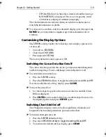


3-8
Raychart 320 Chartplotter
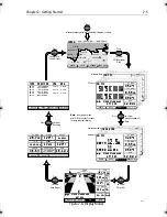
The arrows either side of the steering instruction and pointing towards it
are dependent on the XTE. The first arrow is shown when the difference
reaches 0.01nm and the second at 0.05nm.
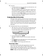
Textual data provides Position, SOG, COG, Bearing and Range to
waypoint, Time and Date, Time To Go (TTG), Steering Indicator,
Sunrise, Sunset, Fix Status and XTE. Any unavailable data is replaced by
dashes, one per character. When there is no GPS fix but there is a value for
the last fix, this is shown instead.
The waypoint name is shown unless there is no target, in which case
NOT
FOLLOWING
is shown. If Goto cursor is in progress,
GOTO CURSOR
is
shown.
The
FIX
status indicates
D-FIX
for a differential fix,
SD-FIX
for a satellite
differential fix,
FIX
for a GPS or other Fix, or
NO FIX
where a fix has not
been acquired. If the simulator is ON, the word
SIMULATOR
appears after
the fix status.
BRG, RNG and XTE data relate to the target waypoint.
Time refers to local time zone which is set in the System Set Up menu, see
Chapter 4
.
The Time To Go (TTG) and Estimated Time of Arrival (ETA) data relate
to the target waypoint (not the whole route) and are based on the Speed
Over Ground (SOG) towards the target. If the Velocity Made Good
(VMG) is negative, or data is not available, these fields are replaced by
dashes, one per character.
Sunrise and Sunset times are for today and at the vessel’s position.
81167_3.BOOK Page 8 Wednesday, November 21, 2001 2:12 PM
Содержание Raychart 320
Страница 2: ...Raychart 320 Chartplotter Owner s Handbook Document Number 81167_3 Date 21st November 2001...
Страница 3: ......
Страница 85: ...3 56 Raychart 320 Chartplotter...
Страница 115: ...5 16 Raychart 320 Chartplotter...
Страница 119: ...6 4 Raychart 320 Chartplotter...
Страница 125: ...C 2 Raychart 320 Chartplotter...
Страница 133: ......
Страница 135: ...T 2 Raychart 320 Chartplotter...
Страница 137: ...T 4 Raychart 320 Chartplotter...


