background image


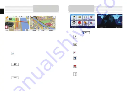
The Map screen is the most important and frequently used screen of the software. The 

Vehimarker (a blue arrow by default) represents your current position, and the orange 

line shows the recommended route. There are screen buttons and data fields on the 

screen to help you navigate. During navigation, the screen shows route information. 


At the top of the screen, you see your heading and the house numbers on left and 

right if you have not selected a route destination. When navigating a route, you see 

the next manoeuvre and the next street/road on your route. Tap either of them to 

open the route itinerary. 


Tap 

 to open the Quick menu with a selection of functions that are useful 

during navigation. 


Tap the map anywhere to explore the map around your current position. Additional 

map control buttons appear. 


Tap 

 to open three data fields on the map. Tap any of them to 

suppress the others. The default values (you can change them in Map settings): 


the remaining distance to the destination, 


the estimated time of the arrival at the destination, and 


the remaining time of the trip. 


Tap 

  to return to the Navigation menu. 


More Screen 

EN
 

EN -12 


The 'More' menu provides you with various options and additional applications. In the 

Navigation menu, tap 


: Fine-tune route planning options, change the look of the Map screen, 

turn on or off warnings, or restart the Configuration wizard, etc. 


: Visit www.naviextras.com to get additional content, such as new maps or 

3D landmarks and useful applications. 


: Access multimedia applications: the Picture Viewer or the Music Player. 


: Access travel applications: the unit converter, the clothing size converter 

or country information. 


: Access other useful applications: the calculator, the fuel and maintenance 

monitor, sunrise and sunset information or the trip and track log monitor. 


: Read the Tutorial to get instant understanding of the functions of your 

software, or run the Demo to watch sample route simulations to see how 

navigation works. 

More Menu


Содержание GeoVision 4766

Страница 1: ...should be placed on the device To prevent the GPS from being damaged be sure to keep the GPS out of direct sunlight or heat Maintain well ventilated conditions around the unit to avoid overheating Th...

Страница 2: ...headphones or headsets 4 microSD Slot Receives microSD memory card for data access or memory expansion 5 Reset Button Press to reset the device 6 Speaker Emits sound voice or music View of Main Unit 1...

Страница 3: ...rt charging Device Connections Connecting to Earphones z Insert earphone jack earphones not included into the appropriate earphone port to switch audio output from device speaker to earphone NOTE High...

Страница 4: ...37 C z It is not necessary to start charging the device before the battery is fully discharged NOTE Please connect the car charger to vehicle 12V accessory cigarette socket after vehicle engine is st...

Страница 5: ...st icon to start pairing with mobile phone device with GPRS function 3 Please make sure Bluetooth function on mobile phone is detectable by other devices 4 Tap on to start searching process 5 Mobile p...

Страница 6: ...ling keypad to dial more numbers 8 Tap on Phone Book icon to view phonebook entries 9 Tap on to browse phonebook entries stored in SIM card 10 Tap to scroll pages up down 11 Select a phonebook entry a...

Страница 7: ...ear on the screen tap or drag the list up or down with your finger to view all available languages Tap to select your preferred language Tap to confirm your selection and proceed to the next page Read...

Страница 8: ...ial setup and whenever the software is started the Navigation menu appears You have the following options Tap to select your destination by entering an address or selecting a place of interest a locat...

Страница 9: ...default the screen proposes the city or town where you are located If needed change the country Tap the button showing the name of the country 1 Use the keyboard to enter the name of the country 2 Aft...

Страница 10: ...seconds or tap and start navigating Navigation EN EN 10 Navigating to a Place of Interest POI On the Map screen tap to return to the Navigation menu In the Navigation menu tap then tap You are offere...

Страница 11: ...er that results in a minimal detour only such as searching for upcoming petrol stations or restaurants Navigation Example for Navigating to a Place of Interest Example To find a park around your desti...

Страница 12: ...ers The default values you can change them in Map settings the remaining distance to the destination the estimated time of the arrival at the destination and the remaining time of the trip Tap to retu...

Страница 13: ...ings They are also used to display the cost and CO2 emission of routes Adjust map related settings change the daytime and night colour schemes change the default zoom level switch between 2D and 3D ma...

Страница 14: ...e unit outdoors if in vehicle you can use the external GPS antenna to solve this problem EN EN 14 To establish connection with PC for data access and synchronization please execute setup file included...

Страница 15: ...Li polymer 1250mAh Operating System Microsoft Window CE6 0 Microsoft Window CE6 0 Speaker 1w 8ohm built in speaker 1w 8ohm built in speaker Video formats supported AVI AVI Audio formats supported MP3...

Отзывы: