


Version 2.0
75
Plot
Operator’s Manual
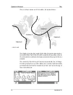
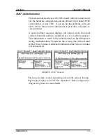
only displayed for the leg of the course you are presently on. If you
reset your cross-track error, these lines are redrawn to reflect the
course change (see
NAV2
).
No
causes the cross-track error lines
not to be displayed. Note that these lines can only be displayed in
Rhumb Line navigation mode (see
CFG1
Navigation
).
¾
Show Lat/Lon Grid
-
No
is the default condition, which causes the
coordinate grid not to be displayed.
Yes
causes the Lat/Lon grid to
be displayed (regardless of positioning reference system selection
in
CFG1
Position
). Note that the grid is only displayed at the 4 Nm
scale or lower.
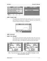
¾
Automatic Zoom
-
No
is the default condition, which causes the
displayed scale to be controlled by you.
Yes
causes the boat icon
to be placed along one edge of the screen and the next waypoint
flag to be placed along the opposite edge of the screen. As you
approach your waypoint, the screen will automatically zoom in on
your course, then expand back out after you pass the waypoint
and start the next leg of your course.
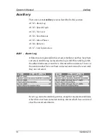
If you press the
Return
softkey, then the
Track Plotter
softkey, you
will access the recorded track options.
Selecting
Erase Track
allows you to clear your recorded track. You can
keep a portion, say the last mile or two, of your recorded track if you
like, by specifying the range after you press the
Erase Track
softkey.
Содержание MX420
Страница 1: ......
Страница 13: ...viii Version 2 0 Operator Manual Table of Contents ...
Страница 181: ...168 Version 2 0 Operator s Manual Automatic Identifaction System ...
Страница 183: ...170 Version 2 0 Operator s Manual Datum List ...
Страница 231: ...Place Stamp Here ADivision of NAVICO Inc 23868 Hawthorne Blvd Suite 201 Torrance CA 90505 USA ...
Страница 235: ......