


® Waves System
V 1.0 - 2008
I.D. AL - GeoPlayer - MP3 and WAV Player with GPS function - Manual
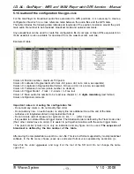
5.1 Creation of the configuration file «gps.csv»
For the GeoPlayer to broadcast audio files associated to GPS positions, it is necessary to create a
configuration file which is a cross reference table between the audio files and the GPS data.
The table includes the following data: latitude and longitude of the position, tolerance around the point,
main audio file number to be broadcast, broadcast mode and optional comments.
Any spreadsheet can be used to create this configuration file, Excel type or Open Office equivalent. An
ID-AL assistant is also available for download from the www.id-al.com web site.
Example of table:
Column A: Position number - maximum 150 points
Column B: Latitude in Degree/decimal format - Dd (use a dot, not a coma, as separator)
Column C: Longitude in Degree/decimal format - Dd (use a dot, not a coma, as separator)
Column D: Tolerance in meters (whole number, no decimal)
Column E: Trigger Mode 1 - Track / 2 - Alarm / 3 - Free tour
Column F: Main audio file number to be read (see chapter 4) - 3 digits mandatory (text format)
Column G: Optional comments
Important notes in creating the configuration file:
- Do not add any column - Do not modify their order
- Do not add any line - no extra header, no empty line nor additional line at the end of the table
- Latitudes and longitudes stated in degree/decimal format
- Do not include units of measure nor symbols (m, km, °, ‘, ...) ONLY values
- It is possible to indicate different trigger modes. The broadcast order is defined by the Track mode order
(the 2 other modes have no order). It is easier to put together locations with the same trigger mode.
- The point number (column A) is only an indication and any figure can be used. The sequence of
broadcast is defined by the line number of the table.
After saving the completed table, export it a «csv» file. This is a text format supported by most spreadsheet
software. In the file menu, choose «save as» and select format «csv separated by semicolon (;)».
Save this file under «gps.csv» and copy it at the root of the SD card. Do not change the name
«gps.csv».
- 13 -


