background image

GR16 GPS Connection Kit

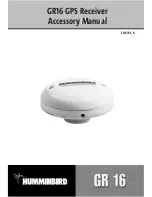
The Humminbird® GR16 GPS Connection Kit includes the following items:

• GR16 GPS Antenna Receiver with 20' (6m) cable  
• AS YC("Y") cable for multiple accessory attachment
• Hardware kit for stem or deck mounting
• GR16 GPS Receiver Accessory Manual

NOTE: 

10 foot extension cables are available as an optional purchase item.  These can be used

to extend the total GR16 Antenna Cable length up to 50 feet.

How GPS and Trackplotting Work 

Your Humminbird® uses GPS and sonar to determine your position, display it on a grid, and
provide detailed underwater information. The Global Positioning System (GPS) is a satellite
navigation system designed and maintained by the U.S. Department of Defense. GPS was
originally intended for military use; however, civilians may also take advantage of its highly
accurate position capabilities, typically /- 10 meters, depending on conditions. This
means that 95% of the time, the GPS receiver will read a location within 10 meters of your
actual position. Your GPS Receiver also uses information from WAAS (the Wide Area
Augmentation System), EGNOS (the European Geostationary Navigation Overlay Service), and
MSAS (the MTSAT Satellite Augmentation System) satellites if they are available in your area.

GPS uses a constellation of 24 satellites that continually
send radio signals to the earth. Your present position is
determined by receiving signals from up to 16 satellites and
measuring the distance from the satellites.

All satellites broadcast a uniquely coded signal once per
second at exactly the same time.  The GPS receiver on your
boat receives signals from satellites that are visible to it.
Based on time differences between each received signal,
the GPS receiver determines its distance to each satellite.
With distances known, the GPS receiver mathematically
triangulates its own position.  With once per second
updates, the GPS receiver then calculates its velocity and
bearing.

1

Содержание AS GR16

Страница 1: ...531478 1_B GR16 GPS Receiver Accessory Manual GR16 GPS Receiver Accessory Manual...

Страница 2: ...r website at www humminbird com WARNING Thisdeviceshouldnotbeusedasanavigationalaidtopreventcollision grounding boatdamage orpersonalinjury Whentheboatismoving waterdepthmaychangetooquickly to allow t...

Страница 3: ...ew 9 View Orientation 9 Introduction to Navigation 10 Waypoints Routes and Tracks 10 Save Edit or Delete a Waypoint 11 Navigate to a Waypoint or Position 12 Add a Waypoint Target or Trolling Grid 13 S...

Страница 4: ...ost recently created waypoint 28 Navigation Menu Tab 30 Current Track 31 Saved Tracks 31 Waypoints 32 View Orientation 33 North Reference 33 Grid Rotation 33 Trackpoint Interval 34 Track Min Distance...

Страница 5: ...products sold outside of the U S by our authorized International Distributors To obtain a list of authorized International Distributors please visit our website at www humminbird com or contact our C...

Страница 6: ...s depending on conditions This means that 95 of the time the GPS receiver will read a location within 10 meters of your actual position Your GPS Receiver also uses information from WAAS the Wide Area...

Страница 7: ...the NMEA cable attached to the antenna 2 If you are already using other Fishfinder accessories plugged into the COM connector youwillalsoneedtousetheAS YC Y cableincludedinyourGR16GPSHardwareKit so t...

Страница 8: ...thedeviceyouare connecting to your Fishfinder The pinouts of this cable are as follows Red Wire 12V output voltage only Black Wire Ground White Wire NMEA Out CAUTION Please use caution before connecti...

Страница 9: ...ed mounting location Mark the location and drill a 3 4 19 mm hole for the cable and cable connector If you have purchased hardware to stem mountyourGPSreceiver followtheinstructionsincludedwith that h...

Страница 10: ...rce Center at 1 800 633 1468 to purchase extension cables 2 Mark the mounting location and drill a 3 4 19 mm hole for the cable and cable connector Secure the NMEA pigtail to the cable with electrical...

Страница 11: ...l tape 3 The GPS Receiver has two wire routing notches Use the cable notch closest to the intended cable route 4 With the cable routed position the GPS Receiver in the planned mounting location and ma...

Страница 12: ...the position of the eye point will shift This allows you to move and turn the eye point so that you can look off to the sides or evenbehindtheboat PressingtheRIGHTorLEFTarrowkeysonthe4 WAYCursorkeytu...

Страница 13: ...se the 4 WAY Cursor keys to move the grid around on the display in the direction of thekeybeingpressed Whenyoudothis abullseyecursorisdrawnatthecenterofthescreen and is linked to the boat by a gray li...

Страница 14: ...d tothenorthoftheboataredrawnabovetheboat WhenCourse Uporientationisselected the directionofmotionoftheboatisshownatthetopofthedisplay Inotherwords objectsahead oftheboataredrawnabovetheboat Inbothori...

Страница 15: ...ypoint to the next As you travel a route staying on the route line is the most efficient way to get to your destination although you should always look out for obstacles not shown on the chart Tracks...

Страница 16: ...nu From any view press the MENU key twice to display the Main Menu System then use the RIGHT Cursor key to select the Navigation tab Select Waypoints and press the RIGHT Cursor key to display the Wayp...

Страница 17: ...gate Press the MENU key once to display the NavigationX Press menu SelectGoToandpresstheRIGHTCursorkey Navigationwillbegin immediately Navigate to a specified waypoint Press the MENU key once to displ...

Страница 18: ...hich you want to add the grid The trolling grid will appear on all of the navigation views and can be used as a guide when trolling around a waypoint The grid can be rotated to any desired heading usi...

Страница 19: ...a saved track From the Tracks submenu select Edit and press the RIGHT Cursor key to displaythelistofsavedtracks SelectthetrackyouwanttoeditandpresstheRIGHTCursorkey When the Edit Track dialog box appe...

Страница 20: ...l appear depending on the view you are in Main Menu Tabs Less frequently adjusted menus are grouped into the Main Menu System The Main Menu system is organized under the following tab headings to help...

Страница 21: ...witch back to NormalMode Forexample ifyousetspecificviewstobevisiblewhileinAdvancedUserMode andthenreturntoNormalUserMode thoseviewswillstillbevisible SeeSetupMenuTab User Mode for specific instructio...

Страница 22: ...n yourFishingSystemusesadvancedtransducerdetectionmethodstodetermineifatransducer is connected If a functioning transducer is connected Normal operation will be selected automatically at power up and...

Страница 23: ...will appear on the display periodically to remind you that you are using the Simulator Exit the Simulator by powering your Fishing System off System Status Use System Status to view system connection...

Страница 24: ...telliteisbeingusedtodetermineyourcurrentposition A light gray bar indicates that the satellite is being monitored but is not yet being used NOTE The GPS Diagnostic View only appears if the GPS Receive...

Страница 25: ...he use of the PC Connect Cable Complete instructions are included with the PC Connect Cable accessory NOTE The PC Connect Cable requires a separate purchase For more information visit our website at w...

Страница 26: ...cess the Sonar X Press menu NOTE Menuchoiceswillvarydependingonsystemsettingssuch as whether the unit is set for Advanced User mode TheMarkandCancelNavigationmenuselectionswillbeadded to the Sonar X P...

Страница 27: ...oint Cancel Navigation only when Navigating CancelNavigationdiscardsthecurrentrouteandexitsNavigationMode Thismenuchoicewill only appear when you are currently navigating a route To Cancel Navigation...

Страница 28: ...gs such as whether you are currently navigating The Navigation X Press menu will be added to the menu systemwhenaGPSisconnectedtotheFishingSystem andwill contain the following choices Mark Zoom Go To...

Страница 29: ...or Control keys to increase or decrease the Zoom level Go To Go To allows you to start Navigation towards a waypoint If the Cursor is active choosing Go To creates a waypoint and starts navigation tow...

Страница 30: ...3 Use the RIGHT 4 Way Cursor Control key to view the Waypoints submenu which contains the following menu choices The Waypoint Submenu contains the following menu choices EditallowsyoutoedittheName Po...

Страница 31: ...yed After the current track is saved a new current track is started To Save Current Track 1 Highlight Save Current Track on the Navigation X Press menu 2 Use the RIGHT 4 WAY Cursor Control key to init...

Страница 32: ...discardsthecurrentrouteandexitsNavigationMode Thismenuchoicewill only appear when you are currently navigating a route To Cancel Navigation 1 Highlight Cancel Navigation on the Navigation X Press menu...

Страница 33: ...w 1 Highlight Sonar Window on the Navigation X Press menu 2 Use the LEFT or RIGHT 4 WAY Cursor Control keys to adjust the size of the sonar window Wide Medium Narrow Default Medium Waypoint Name Most...

Страница 34: ...lete allows you to delete a waypoint from the list of saved waypoints Go To allows you to select a waypoint and start navigation toward that waypoint or add that waypoint to the end of the current rou...

Страница 35: ...The Navigation Menu Tab will be added to the menu system when the GR16 is connected to your Fishing System and the following menu choices will appear in the menu tab Current Track Saved Tracks Waypoi...

Страница 36: ...ashed Line or Solid Line and if a line the color of the line from light to dark gray to black Saved Tracks SavedTracksallowsyoutoviewtheSavedTrackssubmenu To view the Saved Tracks Submenu 1 Highlight...

Страница 37: ...Edit allows you to choose from a list of previously saved waypoints then edit the Name Position Latitude and Longitude and select the Icon that will be used to represent the waypoint in the Track and...

Страница 38: ...displayed with one of two orientations True North or Magnetic North To change the North Reference setting 1 Highlight North Reference on the Navigation main menu 2 Use the LEFT or RIGHT 4 WAY Cursor...

Страница 39: ...lues will allow you to increase the track resolution Track Min Distance Advanced TrackMinDistanceallowsyoutosetaminimumdistanceoftravelbeforeatrackpointisadded to the track The Track Min Distance menu...

Страница 40: ...ojectsyourcurrentcourse andshowswhere the boat will go if you continue on your present course To change the Course Project Line setting 1 Highlight Course Projection Line on the Navigation main menu 2...

Страница 41: ...ey The alarm will be silenced and will not be triggered again until a new instance of the alarm condition is detected The following menu choices will be added to your Alarms Menu Tab when a Handheld G...

Страница 42: ...tionalModelsonly Default 300 ft 100 m Arrival Alarm Arrival Alarm sounds when the boat has either exceeded the distance to the destination waypoint or has entered the Arrival Alarm Circle based on the...

Страница 43: ...e boat s anchored position if the anchored boat drifts outside of that perimeter the Drift Alarm will sound To change the Drift Alarm setting 1 Highlight Drift Alarm on the Alarms main menu 2 Use the...

Страница 44: ...cessories are attached to the unit The following menu choices will be added to your Setup Menu Tab when a Handheld GPS is connected to the Fishing System Units Distance Units Speed Triplog Reset Local...

Страница 45: ...Setup menu 2 Use the LEFT or RIGHT 4 WAY Cursor Control keys to change the Units Speed setting kph InternationalModelsonly mph kts Default kphforInternationalmodelsand mph for Domestic models Triplog...

Страница 46: ...to change the Local Time Zone Default EST UTC 5 Eastern Standard Time Daylight Saving Time Advanced Daylight Saving Time adjusts the time display to account for local Daylight Saving Time Selecting O...

Страница 47: ...mmm or dd mm ss Default dd mm mmm Time Format Advanced International only Time Format changes the time format used by the unit This menu choice is available only when in Advanced User Mode see Setup...

Страница 48: ...Use the LEFT or RIGHT 4 WAY Cursor Control keys to change the Date Format mm dd yy dd mm yy or yy mm dd Default mm dd yy NMEA Output Advanced NMEA Output turns the NMEA output on or off This menu choi...

Страница 49: ...NMEA Output on or off 1 MakesureyouareinAdvancedUserMode thenhighlightNMEAOutputontheSetup menu 2 Use the LEFT or RIGHT 4 WAY Cursor Control keys to change the NMEA Output to On or Off Off On Default...

Страница 50: ...g removing corrosion from the battery terminals or wiring or actually replacing the battery if necessary Fishing System Defaults to Simulator with a Transducer Attached Aconnectedandfunctioningtransdu...

Страница 51: ...of air and water flowing around the transducer cavitation may be interfering with the inter pretation of sonar data See your Installation Guide for suggestions on adjusting the transducer position El...

Страница 52: ...appears To determine whether the boat s engine is the source of the noise increase the RPMs while the boat is in neutral and stationary to see if the noise increases pro portionately if noise appears...

Страница 53: ...from a SmartCastTM Remote Sonar Sensor RSS Radio signals from the RSS are received by the WSL and are transmitted over the Accessory Bus to the Fishing System PCConnectCable PurchasethePCConnectCablet...

Страница 54: ...plotter describes a navigation device that shows Present Position on a Map along with Tracks Waypoints and Routes All Chartplotters are also considered Trackplotters All Humminbird GPS Combo units are...

Страница 55: ...r such as that included with many Humminbird products receives the signals from these satellites and is able to determine position based on very slight differences in the time each signal is received...

Страница 56: ...of waypoints linked together in a specific sequence to define a navigation path between two points and saved in the fishfinder s memory Routes are often used when frequently traveling between two or m...

Страница 57: ...of travel between two waypoints and representsthemostefficientpathbetweenthetwopointsbecauseitisastraightline TheTRK is measured in degrees i e 321 where 000 is North 090 East 180 is South 270 is West...

Страница 58: ...ole or anywhereelsetheusermaywanttoreturnto Humminbird productsoffertheabilitytoname and assign a symbol to the saved location Depth Date and Time of Day when the waypoint was created is also saved Wa...

Страница 59: ...Notes 54...

Страница 60: ...ys By Telephone Monday Friday 8 00 a m to 4 30 p m Central Standard Time 1 800 633 1468 By e mail typically we respond to your e mail within three business days custserv johnsonoutdoors com For direct...
Отзывы: