


A-4
Revision 2 Nov/2002
KMD 550/850 FIS Addendum
Appendix A
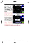
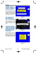
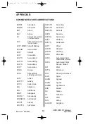
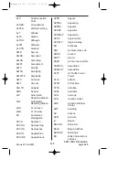
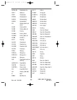
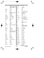
T01760158. Selected stations may also include a 9 place code indi-
cating temperature and dewpoint to the nearest 1/10 degree. T
denotes temperature. 0 indicates temperature is above 0° Celsius.
A “1” in this position indicates a temperature below 0° Celsius. 176
indicates a temperature of 17.6° Celsius. The next 0 indicates the
dew point is above 0° Celsius. A “1” in this position indicates a dew
point below 0° Celsius. 158 indicates a dewpoint of 15.8° Celsius.
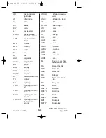
PK WND 22030/15. Selected stations may include peak wind
observations which will appear in the remarks element.
PK WND denotes peak wind.
200 indicates wind direction from 200°.
30/15 indicates a maximum instantaneous wind of 30 knots occurred
at 15 minutes past the hour.
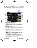
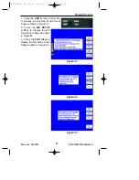
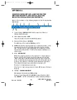
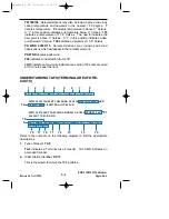
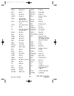
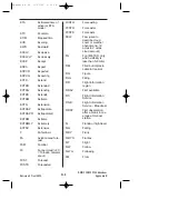
UNDERSTANDING TAFS (TERMINAL AREA FORE-
CASTS)
Refer to the numbers on the following diagram to find the appropriate
descriptions.
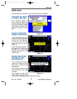
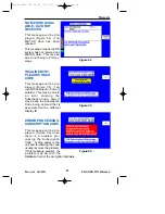
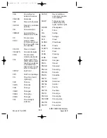
1.
Type of Report: TAF
TAF indicates a Terminal Area Forecast. TAF AMD indicates an
amended forecast.
2.
ICAO Station Identifier: KPIT
This is the airport for which the TAF pertains.
TAF KPIT 091730Z 091818 22020KT 3SM -SHRA BKN020
FM2030 30015G25KT 3SM SHRA OVC015 WS015/30045KT
TEMPO 2022 1/2SM TSRA OVC008CB
FM0100 27008KT 5SM -SHRA BKN020 OVC040 PROB40 0407
00000KT 1SM -RA BR
FM1000 22010KT 5SM -SHRA OVC020 BECMG 1315 20010KT
P6SM NSW SKC
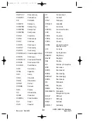
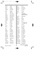
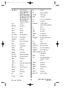
1
3
4
5
2
6
7
8
9
10
11
15
14
13
12
16
17
18
19
20
21
Appendix A R2 11/21/02 5:31 PM Page 4


