background image

AV8OR 3D

 User Guide

                                                                                                                             1  

DRAFT – FOR REVIEW ONLY

User Guide: 

Chapter 1

Introduction to Software Installation

Version 4.4      Size: 7 x 9     Mode: Printing     

5/23/06 

1

Quick Start Guide

Overview


This quick-start section will get you up and running with the basic features of 

A

V

8OR 3D

. Subsequent chapters will guide you through using 

AV8OR 3D

 from 

flight planning all the way to touchdown. 
After you become familiar with 

AV8OR 3D

, you can refer to subsequent sections to 

obtain information about customizing the configuration of your 

AV8OR 3D

.

Now, let’s get started...

Your Tablet PC

While the Tablet PC is a multifunction device that you can use as a home 
computer, it has been specifically configured by 

Honeywell

 to 

run the 

AV8OR 3D

. This includes display and other settings within the PC. Altering 

these settings may affect 

AV8OR 3D

 functionality. 

Installing 

AV8OR 3D

 in Your Aircraft

Refer to Section 2, “Installing 

AV8OR 3D

 in Your Aircraft” for details on the 

following procedures: 

“Installing the INU and Antenna” on page 13.

“Attaching the Mount” on page 14

“Connecting the Power Supply and Cables” on page 15

Содержание BendixKing AV8OR 3D

Страница 1: ......

Страница 2: ...oneywell International Inc Honeywell International Inc 23500 W 105th Street Olathe KS 66061 U S A CAGE 22373 Telephone 800 601 3099 U S A Canada Telephone 602 365 3099 International AV8OR 3D User s Guide ...

Страница 3: ... wholly owned subsidiaries or a formally designated third party service provider thereunder and direct recipients of Materials from Honeywell s Aerospace Technical Publication Distribution The terms and conditions of this License Agreement govern your use of these Materials except to the extent that any terms and conditions of another applicable agreement with Honeywell regarding the operation mai...

Страница 4: ... that is confidential and proprietary to Honeywell You agree to take all reasonable efforts to maintain the confidentiality of these Materials 4 Assignment And Transfer This License Agreement may be assigned to a formally designated service designee to the extent allowed under an applicable product support agreement or transferred to a subsequent owner or operator of an aircraft containing the sub...

Страница 5: ...RADE WHICH ARE HEREBY EXPRESSLY DISCLAIMED OR ii WARRANTIES AGAINST INFRINGEMENT OF INTELLECTUAL PROPERTY RIGHTS OF THIRD PARTIES EVEN IF HONEYWELL HAS BEEN ADVISED OF ANY SUCH INFRINGEMENT IN NO EVENT WILL HONEYWELL BE LIABLE FOR ANY INCIDENTAL DAMAGES CONSEQUENTIAL DAMAGES SPECIAL DAMAGES INDIRECT DAMAGES LOSS OF PROFITS LOSS OF REVENUES OR LOSS OF USE EVEN IF INFORMED OF THE POSSIBILITY OF SUCH...

Страница 6: ... Honeywell International Inc Copyright Notice Copyright 2008 Honeywell International Inc All rights reserved Honeywell is a registered trademark of Honeywell International Inc All other marks are owned by their respective companies ...

Страница 7: ...1 Activating Your XM Satellite Receiver 2 Understanding the AV8OR 3D Display 3 Top Information Area 4 Bottom Information Area 4 Altimeter 5 Course Deviation Indicator 6 Using Buttons and On screen Menus 7 Using Tablet PC Buttons and Main Display Items 7 Using On screen Menus 8 Shutting Down AV8OR 3D 11 Chapter 2 Installing AV8OR in Your Aircraft 13 Installing the INU and Antenna 13 INU Panel Indic...

Страница 8: ...playing Views 26 Checking the Weather 32 Terrain Awareness TAWS 38 Navigating 39 Creating a Direct To 39 Radar Vectors 44 Amending Your Flight Plan 45 Displaying the Nearest Object 46 Activating Approach Procedures 48 Shutting Down AV8OR 3D 50 Using the Simulator Mode 50 Chapter 4 Configuring Your AV8OR 3D 53 Configuration Settings 53 Display Settings 54 Time and Date 56 INU and Simulator 57 GPS 5...

Страница 9: ...anty and Technical Support 67 Important Safety Precautions and Environmental Specifications 67 Electrical Safety 67 Battery 67 Pollution Degree Category 67 Other Required Disclosures and Compliances 67 CSA Approval 67 End User License Agreement 68 Warranty 71 Technical Support 75 ...

Страница 10: ...DRAFT Contents iv AV8OR 3D User Guide ...

Страница 11: ...ll help you to navigate in even the most challenging situations A Word of Caution Although AV8OR 3D is a situational awareness tool AV8OR 3D is not to be used for primary navigation All terrain information is relative to your GPS position and barometric pressure readings and so is subject to error Airports navaids airspaces as well other airport data is provided by Honeywell and can also be subjec...

Страница 12: ...DRAFT Welcome to AV8OR 3D v AV8OR 3D User Guide ...

Страница 13: ...sections to obtain information about customizing the configuration of your AV8OR 3D Now let s get started Your Tablet PC While the Tablet PC is a multifunction device that you can use as a home computer it has been specifically configured by Honeywell to run the AV8OR 3D This includes display and other settings within the PC Altering these settings may affect AV8OR 3D functionality Installing AV8O...

Страница 14: ...ew activation signal The XM activation phone number is 800 967 2346 3 Wait for the XM weather receiver to be activated from an XM satellite It may take from several minutes to up to 1 hour to retrieve the activation signal 4 Press the Menu button to display the menu items on the left side of the screen 5 Press the Cfg button to enter the Setup dialog 6 Select the XM info tab 7 In the connection se...

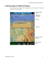
Страница 15: ...ide 3 Understanding the AV8OR 3D Display This is the main view of AV8OR 3D It displays the terrain in 2D and 3D along with information about the flight Top Information Area Flight Plan Information Menus Altimeter Course Deviation Indicator Position Data Area ...

Страница 16: ... if a flight plan is activated as well as the identifier of the nearest airport Both of these items show the bearing to it BRG the distance to it DST and the estimated time en route ETE to reach that point based on the current ground speed of the aircraft Estimated local time of arrival The estimated time of arrival ETA is given in the time zone set on the PC not necessarily the time zone of the d...

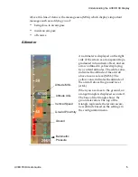
Страница 17: ... an arrow outlined in yellow displaying two current altitudes The white value indicates the altitude of the aircraft above mean sea level MSL The yellow value indicates the altitude of the aircraft above the ground level AGL When you are close to the ground an orange triangle is displayed as an alert The base of the triangle shows the ground elevation The top of the triangle represents the terrain...

Страница 18: ...w and the numerical value are not displayed Target Altitude The target altitude is displayed only when an instrument procedure is activated It shows what the altitude of the aircraft should be at the current position in rela tion to the approach Course Deviation Indicator The course deviation indicator CDI is only displayed when an instrument proce dure or a flight plan is activated The direction ...

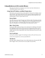
Страница 19: ...ons VORs or NDBs that are close to the position of the aircraft It has the same action as selecting NRST in the menu The NRST button will always be available to you to use regardless of which mode you are in Menu Enter Button Pressing the MENU button activates an on screen menu containing a list of items to be displayed on the left side of the screen Once the on screen menu is active the center bu...

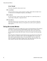
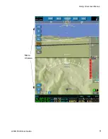
Страница 20: ...ular menu option Using On screen Menus AV8OR 3D has a menu providing easy access to the many features of the software This menu is activated by pressing the MENU button in the Top Information Area A list of menu items will appear on the left side of the screen Menu items can be opened by using either the stylus or the arrow keypad and then pressing Select When the menu is displayed the left and up...

Страница 21: ...DRAFT Using On screen Menus AV8OR 3D User Guide 9 Menu Choices ...

Страница 22: ...AV8OR 3D User Guide 11 Shutting Down AV8OR 3D To shut down AV8OR 3D 1 Exit the AV8OR 3D program Press the menu button and select the Exit button in the lower left portion of the screen 2 Power off the INU 3 Power off the tablet PC ...

Страница 23: ...DRAFT Shutting Down AV8OR 3D 12 AV8OR 3D User Guide ...

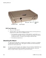
Страница 24: ...ious locations within the aircraft it is important that the two devices be in close proximity to each other within 6 ft When installing the INU you need to consider how easy it is for you to reach the power button Other determining factors for placement are length of the power cords to your power source length of the GPS antenna cable distance of the INU from the tablet PC The INU should be positi...

Страница 25: ...acles between the two devices blocking the signal Try fixing by relocating the tablet and INU INU hardware malfunction Attaching the Mount An optional mounting plate is available for the tablet PC The plate is compatible with the RAM mounting system with options available to fit most aircraft See RAM at www ram mount com Note As opposed to a 2D navigation the synthetic vision provided by AV8OR 3D ...

Страница 26: ... to the cigarette lighter one to the tablet PC and the third to the INU The INU cable has a locking threaded plug on the end Insert this cable into the INU power socket If needed a longer 6 ft power cord for the tablet is available for purchase A power supply clip is included in the package This clip can be screwed under the dash board to hold the power supply ...

Страница 27: ...DRAFT Connecting the Power Supply and Cables 16 AV8OR 3D User Guide ...

Страница 28: ... there is external electrical power to the unit If the unit is running on battery power the LED will not illuminate Starting the Tablet PC To start the tablet PC and AV8OR 3D program 1 Switch on the tablet PC using the sliding power switch on the top of the tablet PC The computer will boot up and display the standard Windows desktop 2 Click the AV8OR 3D desktop icon or find the program in the Star...

Страница 29: ...us of the database the tablet PC will establish a connection to the INU Once the connection is made between the two units the AV8OR 3D application displays the current status of the GPS signal acquisition The INU requires the tracking of at least three satellite signals Once this occurs the tablet PC will indicate that GPS signals are being acquired and that the unit is ready for use On the front ...

Страница 30: ... on Then choose Retry by pressing any tablet PC button If there still is no connection please contact Honeywell Customer Support If your intent is to use the AV8OR 3D simulation mode click on the Simula tion button Starting the Weather Service Turn on the XM weather receiver with the antenna visible to satellites It may take several minutes for the XM receiver to acquire a signal and download weat...

Страница 31: ...y where the wind direction shows from the velocity marks towards the tip of the wind barb A legend of symbols is provided at the bottom of the 2D display when this func tion is selected The altitude for winds aloft may be varied by pressing the and buttons to the right of the Wx menu Lightning Aviator service only Observed lightning is depicted on the 2D map by a small lightning bolt symbol at the...

Страница 32: ...e the altimeter setting press the Barometric Settings field to high light the barometric number 4 Use the rocker button on the top of the tablet PC to adjust the barometric setting up or down 5 Barometric settings may be set using either hPa hectopascal or inHg inch of mercury Warning GPS altitude must be used in pressurized aircraft Creating a Flight Plan To create a new flight plan 1 Select Menu...

Страница 33: ...r Guide Note Flight plans may also be imported from other sources For more information see Downloading Databases Updates and Manuals on page 65 3 Select New from the menu on the right side of the screen This displays the Flight Plan Edit screen ...

Страница 34: ...r Flight AV8OR 3D User Guide 23 4 Name your flight plan by tapping in the Name field to display the Virtual Keyboard and typing a name for your plan Pressing the button to the right of the name field will clear the field ...

Страница 35: ...l bring you to the waypoint search screen where you can search for Airports VORs NDBs and intersections You can press the Info Plates or Wx buttons on this screen to display more information about each waypoint Once you have found the desired waypoint press Insert and the selected waypoint will be entered into the flight plan ...

Страница 36: ...ing a flight plan the previously activated flight plan or instrument procedure if any will be canceled Note You must have more than one waypoint entered in order to activate a flight plan Viewing Airport Diagrams and Approach Plates Airport information including airport diagrams and approach plates can be accessed by either searching for an airport with the Direct To function the Nearest function ...

Страница 37: ... for viewing From the Plates list screen you can choose to view a plate by highlighting the plate and pressing the View button This will open the Plate Viewer The Plate Viewer provides buttons allowing you to zoom in zoom out and rotate the airport diagram Closing this window will return to the main navigation screen In order to return to the list of plates select Plates from the right hand menu I...

Страница 38: ...ew of the terrain and course of the aircraft similar to a moving map display The current filter view VFR1 VFR2 IFR App will dictate whether the ground and navigation features such as obstacles waypoints and airspaces are displayed You can configure these views using the Display Filters on page 63 ...

Страница 39: ...dialog An active flight plan or an instrument procedure is shown as a magenta line The 2D view can be oriented with the track of the aircraft pointing up or with north pointing up You can select this in the Setup dialog under Map orienta tion described in Display Settings on page 54 Track Indicator Track Target VOR NDB Lighted Obstacle Airport Flight Plan Scale ...

Страница 40: ...d Pan You can now use the arrow keys to pan up down left and right of your aircraft position or around airport diagrams or approach charts Heading Indicator in 2D View The heading indicator is displayed as a graduated arc A white arrow indicates the current magnetic track and the numerical value is displayed in degrees just below The aircraft s heading in AV8OR 3D is based on GPS tracking not on t...

Страница 41: ...nding on your filter choices in the Setup dialog Display Filter tab and the scale of the 2D view different types of aeronautical information will be displayed The following kinds of items may be displayed in the 2D view If you have the live weather option and a METAR data is available for an airport a Flight Rule Indicator is displayed under the name of this airport Non lighted obstacle with altit...

Страница 42: ...ircraft to the airspace is considered close based on the same parameter that is set for terrain awareness An airspace is considered close to the aircraft when The airspace is in front of the aircraft and less than 10 nautical miles away and is at the same altitude or within the range or the terrain awareness setting or The airspace is above or below the aircraft within the terrain awareness settin...

Страница 43: ...ind Text None Surface Weather SFC Depending on your level of XM weather subscription surface weather will include NEXRAD Radar METAR Symbols Fronts Lightning TFRs and Echo Tops NEXRAD Radar shows the precipitation in different colors depending on the intensity and the type of the precipitation and the echo tops indicating the highest altitude at which precipitation is falling This function display...

Страница 44: ...the 2D display when this function is selected The levels depicted in the legend will change depending on the current altitude of the aircraft Winds Aloft Wind The winds aloft feature displays wind barbs depicting the wind direction and observed velocity These symbols are displayed in accordance with standard FAA symbology where the wind direction shows from the velocity marks towards the tip of th...

Страница 45: ...se during the initial loading of weather data such as winds aloft when the feature is selected for the first time Text Weather Text Selecting the Text button will bring up a list of all airports currently reporting METAR and or TAF data sorted by distance to your current location High lighting an airport in the list will display the METAR TAF text at the bottom of the window Additional information...

Страница 46: ...zed view based on aircraft position and attitude It is a representation of the cockpit view with additional flight information displayed Objects in the 3D view such as VORs Airports and Intersections are identified with a flag noting the identifier of the object In the case of airports and VORs navigation information is also displayed VOR flags include the VOR name the radial that the aircraft is ...

Страница 47: ...w A yellow arrow represents the value of the magnetic track and contains the numerical value in degrees When a flight plan or an instrument procedure is activated a target course magenta bug indicates the bearing to the next waypoint When this bearing is not in the range of the track indicator a magenta arrow shows the direction of the bearing Track Indicator Bank Indicator Airport Pitch Indicator...

Страница 48: ...ou a prediction of the future position of the plane in 9 seconds It is computed using the current position speed rate of turn and rate of climb of the aircraft Highway in the Sky HITS Navigation guidance is displayed in the 3D view with a highway in the sky HITS representation This shows the track to follow The different waypoints that compose the flight path are displayed as doors on the HITS A m...

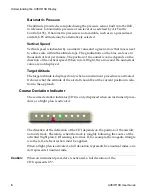
Страница 49: ...than the preset alert altitude and red the aircraft is below the terrain To activate terrain awareness 1 Press Menu to display the menu options 2 Press the TAWS button The alert altitude at which the terrain turns yellow can be set in the Display tab of the Setup dialog When the Terrain Awareness function is turned on the TAWS button is displayed even if the menu is hidden In the 2D view the Terra...

Страница 50: ...on is helpful for building a quick flight plan from the current location to a specific point It can also be used to amend a flight plan To Create a Direct To with a Flight Plan 1 When a flight plan or an instrument procedure is activated select the type FPL This is useful for making a shortcut in a flight plan In this case the list contains the waypoints of the flight plan ...

Страница 51: ... an Airport Type When the airport type is selected the central table displays a list of airports including for each one its name its bearing and its distance from the aircraft posi tion its elevation and the longest runway length The bottom part of the dialog displays the name of the airport its exact location basic information about the runways and the most useful frequencies in use at this airpo...

Страница 52: ...information which you can access by pressing the Wx button on the right side of the dialog This displays a decoded version of the last received METAR and TAF for the selected airport Entering an Airport Code You can search for an airport by directly entering its code in the input field To enter the code with the buttons 1 Highlight the input field 2 Press the ENTER button The up down arrows change...

Страница 53: ...displays only the name and the location of the object The list contains only the name bearing and distance plus the frequency of the VORs The Info and View items are not selectable Direct To with a Weather Station Type Wx If you have the live weather option the Wx type will be available If you select this type the central table displays only the airports for which weather data is available In this...

Страница 54: ...DRAFT Navigating AV8OR 3D User Guide 43 ...

Страница 55: ...tructions from Air Traffic Control ATC To use the Radar Vectors function select RV from the Main menu Any currently active navigation such as a Direct To or Flight Plan will be deactivated and placed on hold In the upper right of the navigation screen you will see the current heading and altitude in magenta The Highway in The Sky HITS will provide guidance for the entered heading and altitude ...

Страница 56: ...a bugs will appear along both indicators marking the selected heading and altitude When Radar Vectoring is completed and you wish to continue your previous navigation simply press the RV button and AV8OR 3D will resume guidance to your previous destination from your new current position Amending Your Flight Plan To amend an existing flight plan 1 Select Menu to display the Menu buttons on the main...

Страница 57: ...creen The type can be selected to show information about the closest airports inter sections VORs or NDBs Inserts a new destination or waypoint in the flight plan The default edit line appears at the end of the flight plan If you select an existing line in the flight plan and tap Insert the new line will appear above the high lighted line Deletes the highlighted airport or waypoint Scrolls up the ...

Страница 58: ...DRAFT Navigating AV8OR 3D User Guide 47 ...

Страница 59: ...rports will have weather information which you can access by pressing the Wx button on the right side of the dialog This displays a decoded version of the last received METAR and TAF for the selected airport Nearest with a Weather Station Type Wx If you have the live weather option the Wx type will be available Select Wx to display only the airports for which weather data is available In this case...

Страница 60: ...our flight plan You can search by airport code or name Tapping in the Code or Name fields displays a Virtual Keyboard You can also select other waypoints from the Type menu on the left side of the screen Displays the detailed airport information Displays the current plates for the airport The airport diagram screen also provides three button allowing you to zoom in zoom out and rotate the airport ...

Страница 61: ...f the screen You will be given the choice of shutting down the tablet PC Turn off going back to Windows Windows or returning to AV8OR 3D Cancel 2 Power off the INU 3 Power off the tablet PC Using the Simulator Mode AV8OR 3D offers a simulation mode which is useful for helping you learn about AV8OR 3D features To enter simulation mode 1 Start the tablet PC for navigation mode without powering on th...

Страница 62: ...start up airport 1 Press the Menu button to display the menu 2 Select the Cfg button to display the Setup dialog 3 Select the INU Simu tab 4 Click on the Position at field A virtual keyboard will display allowing you to select an airport using a 4 letter ICAO station identifier ...

Страница 63: ...n level the aircraft by pressing the Reset button at the top of the simulator pop up window 2 To control the aircraft speed use the stylus to move the slide bar up and down You can also control the overall simulation speed by setting the Simulation rate on the INU Simu tab in the Setup dialog You can reset the simulation by using the stylus to touch the Reset button To stop the simulation 1 Press ...

Страница 64: ... AV8OR 3D Configuration Settings Use the information in the following sections to customize your AV8OR 3D To access the Setup screen press the Menu button and then the Cfg button on the Menu To view all available tabs in the Setup screen press the arrow buttons to scroll left or right through the Setup tabs To close the Setup screen press the Close button ...

Страница 65: ...isplay tab to view the following settings The Display tab allows you to set the following Menu Choice Available Settings Light mode Day or night Map orientation 2D Track or North Horizon on moving map On if you want to see the artificial horizon displayed on the 2D moving map view ...

Страница 66: ...splay all expired TFRs in addition to the one that are already displayed Only next 3 hours TFRs Check to display all TFRs that will be active in 3 hours in addition to the one that are already displayed Show NFL TFRs On to display displays all TFRs around NFL football stadium in addition to the one that are already displayed Terrain awareness Measurement in feet default is 500 ft Default Press to ...

Страница 67: ...DRAFT Configuration Settings 56 AV8OR 3D User Guide Time and Date Press the Time Date tab to view the time and date of your location AV8OR 3D obtains the time from the GPS ...

Страница 68: ...DRAFT Configuration Settings AV8OR 3D User Guide 57 INU and Simulator Press the INU Simu tab to view the following INU and Simulator settings ...

Страница 69: ... If the INU is not set perfectly flat in the aircraft you can specify the pitch and bank angles by tapping to highlight the field and using the rocker button on the top of the tablet PC to adjust the setting up or down Reset connection Resets the connection between the INU and the tablet PC Menu Choice Available Settings Start Stop Starts or stops a simulation flight Position at Set the current po...

Страница 70: ...h of signals The GPS tab provides a visual reference of satellite acquisition status The signal bars give the strength of the signal for each satellite in view The sky view shows the location of each satellite relative to the receiver s last known position The INU requires the tracking of at least three satellite signals ...

Страница 71: ...DRAFT Configuration Settings 60 AV8OR 3D User Guide Power Press the Power tab to display the power status of both the LS800 tablet PC and the INU 75GB ...

Страница 72: ...eiver unit It also provides informa tion about the connection between the tablet PC and this receiver your receiver serial number the type of service you subscribe from XM and the quality of the signal low values of BER indicate a good reception The table on the bottom right of the dialog displays a list of received products and the elapse time since the last transmission ...

Страница 73: ...ucts displayed are METAR TAF TFR High Resolution NEXRAD Radar Precipitation Type at surface Satellite Mosaic Weather Press the Weather tab to display the NEXRAD Radar Precipitation and Clouds Tops Satellite Mosaic legend The checkbox allows you to deactivate the weather animation ...

Страница 74: ...You can modify the features that you want to see on the display for the 2D and 3D views On each view you have up to 4 display filter configurations that you can set up the way you want You can cycle through these 4 configurations by pressing the VFR1 VFR2 IFR App button ...

Страница 75: ...s AV8OR 3D logs flight information for every flight using the INU Each time you start a flight AV8OR 3D detects your departure airport and your arrival airport AV8OR 3D logs the airports the duration of the flight and the date of the flight in the Log Flights tab ...

Страница 76: ...custom battery pack This battery pack is to be replaced only by an approved Honeywell facility Any attempt to change the battery yourself or to open the case of the INU will void the warranty of the unit Pollution Degree Category This product is categorized as Pollution Degree II and Over Voltage Category II Other Required Disclosures and Compliances This device complies with Part 15 of the FCC Ru...

Страница 77: ...cluding details regarding your warranty visit www Bendixking com For technical support of this product please contact your local Bendix King Dealer To locate the Bendix King Dealer nearest you visit www Bendixking com For additional support contact Honeywell Customer Product Support at US Canada 800 601 3099 International 602 365 3099 Fax 602 365 3343 ...

Страница 78: ... com wps portal aero to Download or see publications online Make an order for a publication Tell Honeywell of a possible data error in a publication If you do not have access to the Honeywell Online Technical Publications web site and need technical publications information Send an e mail message to the complete customer care center at cas publications distribution honeywell com Send a fax or spea...

Отзывы: