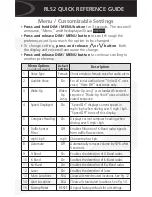
-
66
-
Appendix I
Channel Distribution
The Vertical Angles (Elevation) in the table below are design values.
The accurate values are in this lidar's unit's calibration file, see Section 1.3 (Channel Distribution) and Section 3.1.3 (Point Cloud Data Analysis).
Channel #
in UDP Data
Horizontal Angle Offset
(Azimuth)
Vertical Angle
(Elevation)
Instrument Range
(in meters)
Range (in meters)
with Reflectivity
01 (Top)
0°
15°
120
50@10%
02
0°
13°
120
50@10%
03
0°
11°
120
50@10%
04
0°
9°
120
50@10%
05
0°
7°
120
80@10%
06
0°
5°
120
80@10%
07
0°
3°
120
80@10%
08
0°
1°
120
80@10%
09
0°
-1°
120
80@10%
10
0°
-3°
120
80@10%
11
0°
-5°
120
80@10%
12
0°
-7°
120
80@10%
13
0°
-9°
120
50@10%
14
0°
-11°
120
50@10%
15
0°
-13°
120
50@10%
16 (Bottom)
0°
-15°
120
50@10%
Содержание PandarXT-16
Страница 1: ...www hesaitech com HESAI Wechat PandarXT 16 16 Channel Medium Range Mechanical LiDAR User Manual ...
Страница 19: ... 17 2 Setup 2 1 Mechanical Installation Figure 2 1 Front View Unit mm ...
Страница 20: ... 18 Figure 2 2 Bottom View Unit mm ...
Страница 21: ... 19 2 1 1 Recommended Installation Figure 2 3 Recommended Installation ...
Страница 28: ... 26 2 3 2 Connection Figure 2 9 Connection Box Connection with GPS ...
Страница 29: ... 27 Figure 2 10 Connection Box Connection with PTP ...