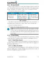
background image

21

190-00587-02  Rev. E

Garmin GTS Traffic Systems

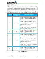
6.4.1.2  TA Criteria

Targets may become a TA based on closure rate (time until collision) or if they 

encroach within a minimum distance. The criteria used depend on the current 
sensitivity level and whether the target has altitude reporting capability. Once a 
TA is generated, it will remain a TA for at least 8 seconds, even if the target no 
longer satisfies the criteria for a TA. Table 4 summarizes the criteria used for TAs. 

Sensitivity 

Level

Intruder Altitude 

Available

TA Alerting Conditions

A

Yes

Intruder closing rate provides less than 20 
seconds of vertical and horizontal separation. 
Or: 
Intruder closing rate provides less than 20 
seconds of horizontal separation and vertical 
separation is within 600 feet.
Or: 
Intruder range is within 0.2 NM and vertical 
separation is within 600 feet. 

A

No

Intruder closing rate provides less than 15 
seconds of separation or intruder range is 
within 0.2 NM. 

B

Yes

Intruder closing rate provides less than 30 
seconds of vertical and horizontal separation. 
Or: 
Intruder closing rate provides less than 30 
seconds of horizontal separation and vertical 
separation is within 800 feet. 
Or: 
Intruder range is within 0.55 NM and vertical 
separation is within 800 feet. 

B

No

Intruder closing rate provides less than 20 
seconds of separation or intruder range is 
within 0.55 NM. 

Table 4  TA Alerting Criteria

Содержание GTS 820 TAS

Страница 1: ...GTS Traffic Systems Pilot s Guide...

Страница 2: ...nual may be reproduced copied transmitted disseminated downloaded or stored in any storage medium for any purpose without the express written permission of Garmin Garmin hereby grants permission to do...

Страница 3: ...nty also does not apply to and Garmin is not responsible for any degradation in the performance of any Garmin navigation product resulting from its use in proximity to any handset or other device that...

Страница 4: ...terials or workmanship for the earlier of 2 years or 800 flight hours from the date of purchase WARNINGS AND CAUTIONS WARNING The GTSTAS andTCAS I systems are intended for advisory use only to aid the...

Страница 5: ...providers You acknowledge that the Software is the property of Garmin and or its third party providers and is protected under the United States of America copyright laws and international copyright t...

Страница 6: ...iv Garmin GTS Traffic Systems 190 00587 02 Rev E...

Страница 7: ...mni Directional Antenna 11 4 3 External Amplifier 11 4 3 1 GPA 65 Amplifier Module GTS 820 850 only 11 Section 5 System Interfaces 12 5 1 Altitude Source 12 5 2 Transponder Interface 12 5 3 Traffic Di...

Страница 8: ...S Targets 28 6 8 2 Radar Altimeter 28 6 8 3 Calculated Height Above Ground 28 6 9 Self Test 29 Section 7 Q and A 30 7 1 What are the benefits of ADS B 30 7 2 When is ADS B In available 30 7 3 How are...

Страница 9: ...5 TCAS II Refers to the GTS 8000 NOTE Details on the GTS 8000 TCAS II operation are not included in this guide For information on a GTS 8000TCAS II system refer to the aircraft specific installation d...

Страница 10: ...stems with system software version 4 00 and later and in GTS 825 and GTS 855 systems with system software version 3 00 and later Earlier software versions provide limited ADS B IN functionality Positi...

Страница 11: ...other 978 MHz the ground station will retransmit the data from each aircraft on the other link to ensure the two aircraft can see each other The GTS is capable of receiving ADS B directly on the 1090...

Страница 12: ...ound track TIS B data is broadcast once every three to thirteen seconds depending on the characteristics of the FAA radar ground station The GTS is capable of active surveillance and will directly tra...

Страница 13: ...le 2 Product GTS 800 GTS 820 GTS 825 GTS 850 GTS 855 Type TAS TSO C147 Class A TAS TSO C147 Class A TAS TSO C147 Class A TCAS I TSO C118 TCAS I TSO C118 ADS B Capability TSO C166b TSO C195b Note 1 2 T...

Страница 14: ...raft interfaces Figure 4 GTS System Processor 4 1 1 GTS 800 820 850 System Processors The GTS 800 820 850 systems use a unique system processor The GTS 800 system processor is different from a GTS 820...

Страница 15: ...e installed on the bottom of the aircraft to improve performance A bottom mounted antenna adds additional visibility for targets that could be shaded from the top antenna for example targets that are...

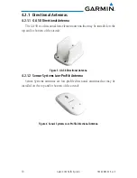
Страница 16: ...ur element antenna that may be installed on the top and or bottom of the aircraft Figure 5 GA 58 Directional Antenna 4 2 1 2 Sensor Systems Low Profile Antenna Sensor Systems antennas are low profile...

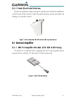
Страница 17: ...ircraft Omni directional antennas cannot determine the bearing to an intruder aircraft Figure 7 Bottom Mounted Omni Directional Monopole Antenna 4 3 External Amplifier 4 3 1 GPA 65 Amplifier Module GT...

Страница 18: ...800 systems transmit at a lower power level and do not require a transponder interface 5 3 Traffic Display At least one traffic display is required and multiple traffic displays are supported The traf...

Страница 19: ...m that can provide position groundspeed and altitude GPS calculated GPS input may be used to enable several functions including ADS B In automatic air ground determination or calculated height above g...

Страница 20: ...tems using SW v3 12 or later the unit can be configured to have the ADS B In function operate independent of active surveillance When configured to operate independently the ADS B In feature turns on...

Страница 21: ...ndotheridentifying information ICAO address flight ID tail number Traffic information may be available from several sources such as active surveillance ADS B ADS R and TIS B The GTS correlates data fr...

Страница 22: ...ical trend arrow Relative altitude and vertical trend arrow are not available for targets that do not report altitude Selected Traffic Info ADS B and TCAS Status and Altitude Filter Touch To View Traf...

Страница 23: ...to the traffic display documentation for details regarding off scale TA depictions Proximity Advisory with directional information Points in the direction of the aircraft track Proximity Advisory PA...

Страница 24: ...AIRB is in operation in the en route environment outside of five NM from or more than 1 500 feet above the nearest airport AIRB supports the flight crew s situational awareness and visual acquisition...

Страница 25: ...ity Level A SL A and Sensitivity Level B SL B The Sensitivity Level determines what criteria will be used for TAs SL A is less sensitive and traffic must be closer before it will generate an alert SL...

Страница 26: ...s available 6 4 1 1 3 Groundspeed GPS groundspeed may be used to select the sensitivity level only if height above ground and landing gear position is not available SL A will be used when the groundsp...

Страница 27: ...seconds of vertical and horizontal separation Or Intruder closing rate provides less than 20 seconds of horizontal separation and vertical separation is within 600 feet Or Intruder range is within 0...

Страница 28: ...detect interrogations e g it is too far to receive interrogations it cannot be tracked by GTS active surveillance When ADS B In is installed and active GTS may receive ADS B ADS R or TIS B for an intr...

Страница 29: ...vel Height Above Airport HAA feet Radar Altitude feet Height Above Terrain HAT if available Ownship Altitude feet 4 1 500 and w in 5 NM of airport reference point Any Any Any 4 Unavailable 1 500 Any A...

Страница 30: ...ty Level TA Alerting Conditions 4 Within the next 30 seconds intruder range and relative altitude are predicted to be within 0 20 NM and 400 ft 5 Within the next 35 seconds intruder range and relative...

Страница 31: ...ng cases Another TA is already present or The range to the TA target is less than 0 25 NM NOTE Shortened TA aural alerts are currently only available in GTS 800 GTS 820 and GTS 850 systems with system...

Страница 32: ...air and less than 30 knots indicates on ground Air ground message from a Garmin avionics system Ownship air ground detection is used for the automatic mode switching and calculated height above groun...

Страница 33: ...ve ground using altitude data provided for nearby airports NOTE Height above ground data from a connected display can only be used by GTS 800 GTS 820 and GTS 850 systems with system software version 4...

Страница 34: ...traffic is on the ground will not be displayed unless SURF is active and the target is tracked with ADS B In This is the only method used to determine whether Mode S traffic is on the ground NOTE The...

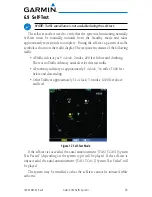
Страница 35: ...fic A Traffic Advisory at 9 o clock 2 miles 200 feet below and climbing There is no Traffic Advisory aural alert for this test traffic A Proximity Advisory at approximately 1 o clock 3 6 miles 1000 fe...

Страница 36: ...ADS B In data for intruder aircraft 7 3 How are active and ADS B In targets displayed Refer to the traffic display documentation to determine the capabilities of each display 7 4 What capabilities doe...

Страница 37: ...0587 02 Rev E Garmin GTS Traffic Systems 7 6 Is ADS B Out required with the GTS Traffic System No The ADS B In feature uses ADS B ADS R and TIS B but the ownship is not required to be equipped with AD...

Страница 38: ...requency Mode A A type of ATCRBS transmission which requests via Mode A interrogations or reports via Mode A replies aircraft identity information Mode C A type of ATCRBS transmission which requests v...

Страница 39: ......
Страница 40: ...66062 U S A Garmin AT Inc 2345 Turner Rd S E Salem Oregon 97302 U S A Garmin Europe Ltd Liberty House Hounsdown Business Park Southampton Hampshire SO40 9LR U K GARMIN Corporation No 68 Jangshu 2nd Ro...

Отзывы: