background image

42 

GPSMAP

®

 4000/5000 Series Owner’s Manual

Using Radar

Using  Radar

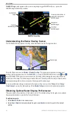
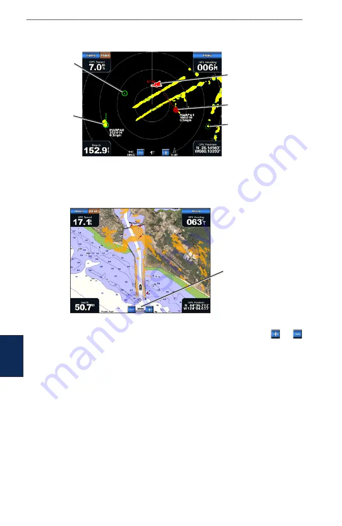
MARPA target 

(only appears when you are targeting a tagged MARPA object)—opens the 

MARPA target information window.

MARPA Targeting

Acquiring  

MARPA target

Tracking 

MARPA target 

Lost MARPA 

target 

Dangerous 

MARPA target

Closest point and time of 

approach to dangerous 

MARPA target

Understanding the Radar Overlay Screen

Use the Radar Overlay option to overlay radar information on the Navigation chart.

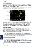
Radar range

From the Home screen select 

Radar

 > 

Radar Overlay

. The radar picture appears in orange and 

overlays the Navigation chart. Use the 

RANGE

 (+/-) keys (GPSMAP 4000 series) or the   and   

keys (GPSMAP 5000 series) to zoom in and out. Zooming while panning the map only affects the 

zoom scale of the map. The radar range remains the same. Zooming while the map is locked on the 

boat (not panning) affects the zoom scale of the map and the radar range.
To access additional settings or options for the radar overlay screen, select


Menu

.


Select 

Setup

 > 

Chart Setup

 to access the chart options. Select 

Radar Setup 

to return to the radar setup options.

Obtaining Optimal Radar Display Performance

The gain controls the sensitivity of the radar receiver. The default setting for the gain, Auto, adjusts 

the gain automatically to provide the best performance.

To adjust the gain:

1.  Select 

Menu

 > 

Gain

 on the radar screen.

2.  Select 

Up

 or 

Down

 to manually adjust the gain; select 

Auto

 to return the gain to the default 

setting.

Содержание GPSMAP 4010

Страница 1: ...GPSMAP 4000 5000 Series owner s manual ...

Страница 2: ...n concerning the use and operation of this and other Garmin products Garmin the Gamin logo GPSMAP AutoLocate TracBack MapSource BlueChart and g2 Vision are trademarks of Garmin Ltd or its subsidiaries registered in the USA and other countries UltraScroll GFS and GHP are trademarks of Garmin Ltd or its subsidiaries These trademarks may not be used without the express permission of Garmin NMEA 2000 ...

Страница 3: ...n GPSMAP 4000 series units or use your finger to touch that item on the screen GPSMAP 5000 series units to select it Small arrows in the text indicate that you should select each item in order For example if you see select Charts Navigation Chart you should press the Charts soft key GPSMAP 4000 series or touch Charts GPSMAP 5000 series and then select or touch Navigation Chart Quick Links Turning ...

Страница 4: ...g System Settings 32 Changing the System Language 32 Configuring Navigation Preferences 32 Configuring Units of Measure 33 Configuring Communications Settings 33 Setting Alarms 34 Setting the Total Fuel Onboard Alarm 35 Configuring My Boat 35 Configuring Other Vessels 36 Using the Garmin Marine Network 37 Viewing Connected Garmin Marine Network Devices 38 Using Radar 39 Using Cruising Mode 40 Usin...

Страница 5: ...utomatic backlight sensor GPSMAP 4012 POWER RANGE ROCKER MARK SELECT HOME MENU Numeric keypad GPSMAP 4010 and 4012 Soft keys Note Use the soft keys to select menu items on the GPSMAP 4000 Series Touch menu items on the GPSMAP 5000 Series screen to select them SD card slot POWER Automatic backlight sensor GPSMAP 5008 ...

Страница 6: ...ess and hold the Power key Warning Screen Home Screen Initializing Unit Settings The first time you turn your unit on you must configure a series of initial settings These settings must also be configured when restoring factory settings Note You can change these settings later using the Configure screen Language select the language to display on your screen Welcome select OK Position Format specif...

Страница 7: ...ly adjust the backlight either select Up or Down use the ROCKER GPSMAP 4000 series or touch and drag the brightness bar GPSMAP 5000 series To adjust the color mode 1 Press and release the Power key 2 Select Color Mode 3 Select Day Colors Night Colors or Auto Acquiring GPS Satellite Signals When you turn the unit on the GPS receiver must collect satellite data and establish its current location Whe...

Страница 8: ...s any information you have entered To restore factory settings 1 From the Home screen select Configure System System Information 2 Select Factory Settings 3 Select Reset to restore all factory settings or select Back to cancel Viewing System Information You can view the software version basemap version and unit ID number for your chartplotter You may need this information to update the system soft...

Страница 9: ...er s Eye 3D Fish Eye 3D and Fishing Charts are available only if you use a BlueChart g2 Vision SD card Radar set up and view radar page 39 Sonar set up and access sonar information page 45 Combinations set up the screen to view a chart sonar radar and video in a two or three GPSMAP 4000 Series field or four GPSMAP 5000 Series field split screen page 19 Where To access navigation features page 21 I...

Страница 10: ...ur course to view map information and as a navigational aid To access the Navigation chart from the Home screen select Charts Navigation Chart Navigation Chart with BlueChart g2 Vision Data Buoy Beacon Your boat Exposed wreck Marine services Zoom scale Submerged wreck Zooming In and Out on the Map The RANGE keys GPSMAP 4000 series or the and keys GPSMAP 5000 series control the zoom level indicated...

Страница 11: ... point on the chart see page 25 Panning the Navigation Chart Use the ROCKER on your GPSMAP 4000 series unit to move the map pointer away from your current location and to scroll to other areas on the Navigation chart As you pan past the edge of the current map display the screen scrolls forward to provide continuous map coverage Touch and drag the Navigation screen on your GPSMAP 5000 series unit ...

Страница 12: ... select a starting point from which to measure distances The distance is displayed in the upper left corner of the screen Create Waypoint mark a waypoint at the pointer location Information view tide current celestial or local services information near the pointer location Accessing Additional Object Information Use the map pointer GPSMAP 4000 series or touch an item on the screen GPSMAP 5000 seri...

Страница 13: ...ss rose Wind direction indicator Wind Compass Rose Data Bars show or hide cruising navigation fishing fuel or sailing numbers Cruising turn the GPS Speed GPS Heading Depth and GPS Position data bar on or off Select Data Bar Setup to configure the position of the data on the screen Navigation turn the Distance to Destination Arrival Off Course and Bearing data bar on or off If you select Auto the c...

Страница 14: ...display to the current track heading Course Up sets the map so the direction of navigation is always up The heading line appears vertically on the screen if shown Detail adjusts the amount of detail shown on the map at different zoom levels Heading Line draws an extension from the bow of the boat in the direction of travel Off turns the heading line off Distance sets the distance to the end of the...

Страница 15: ...MAP 5000 series to move the view closer to your boat and lower to the water Press the RANGE key GPSMAP 4000 series or touch the key GPSMAP 5000 series to move the view away from the boat To view details about navaids such as beacons lights and obstructions 1 Use the ROCKER GPSMAP 4000 series or the touchscreen GPSMAP 5000 series to point to the navaid When the cursor is over the navaid a button is...

Страница 16: ...and the shallow water alarm is activated page 56 an alarm will sound when your boat enters water shallower than this setting Lane Width adjusts the width of the course line drawn when navigating This setting also affects routes Route To but does not affect automatic guidance Guide To Using Radar Overlay When you connect your chartplotter to an optional Garmin marine radar you can use Radar Overlay...

Страница 17: ...en To edit or delete a saved track 1 From the Home screen select Information User Data Tracks Saved Tracks 2 Select the track you want to edit or delete 3 Select Edit Track to change the name or color of the track or select Delete to delete it To set active Track Options From the Home screen select Information User Data Tracks Active Track Options Record Mode select Off Fill or Wrap Off does not r...

Страница 18: ...works well for offshore deep sea fishing High Resolution Satellite Imagery provides high resolution satellite images for a realistic view of the land and water on the Navigation chart Aerial Photos provides a view of marinas and other navigationally significant aerial photos to help you visualize your surroundings Detailed Roads and POI data provides a view of roads restaurants and other points of...

Страница 19: ...he Mariner s Eye 3D screen select Menu For settings and options related to Waypoints Tracks Other Vessels Surface Radar and Data Bars see Perspective 3D Settings on page 11 To customize the appearance of the Mariner s Eye 3D screen select Menu Chart Appearance Style Selects how chart data is displayed over 3D terrain Classic uses color schemes to indicate 3D terrain Charts provides chart informati...

Страница 20: ...h Eye 3D Suspended targets Fish Eye 3D Settings To access additional settings or options for the Fish Eye 3D screen select Menu View selects a fish eye view of Fore Aft Port or Starboard Sonar Cone turns a cone that shows the area covered by your transducer on or off Sonar Data visually shows the sonar readings received by your transducer for the best combination of sonar and mapping Tracks turns ...

Страница 21: ...tos 3 Select one of the following Off standard chart information is shown on the map Land Only standard chart information is shown on water with photos overlaying the land Photo Map photos overlay both the water and the land at a specified opacity The higher you set the percentage of opacity the more the satellite photos will cover both land and water NOTE When enabled the high resolution satellit...

Страница 22: ... icon with the pointer and select Aerial Photo or Review Perspective Overhead Viewing Current Station Information If current stations are available in your BlueChart g2 Vision region they appear on the Navigation chart as highlighted arrows These detailed icons show the speed and direction of the current at a glance Select Review or the name of the station to display a current graph Detailed Road ...

Страница 23: ...Combinations screen shows a list of possible screen combinations When viewing three combination screens one screen is larger than the others The charts are numbered with a corresponding button in the lower right corner GPSMAP 4000 series To switch the larger screen select the icon from the lower right corner that represents the screen you want GPSMAP 4000 series or touch Menu Change Combination GP...

Страница 24: ...te You can only choose from the options available to your unit To increase the number of screens available use a BlueChart g2 Vision SD card or add network devices To add additional data fields 1 While viewing the Combinations screen press the soft key corresponding to an unused data field GPSMAP 4000 series or touch an unused data field GPSMAP 5000 series Adding a Data Field GPSMAP 4000 series Ne...

Страница 25: ...add turns to the route Guide To searches BlueChart g2 Vision chart data to suggest the best path to your destination You must be using a BlueChart g2 Vision SD card for this option to appear Caution Guide To does not ensure obstacle and bottom clearance For safety always resolve any discrepancies or questions before continuing navigation Navigating to a Destination You can search for and navigate ...

Страница 26: ...ation To search for a destination by name 1 From the Home screen select Where To Search by Name 2 Use the ROCKER GPSMAP 4000 series or touch the onscreen keyboard GPSMAP 5000 series to select characters and spell at least a portion of the name of your destination Search GPSMAP 4000 series Search GPSMAP 5000 series 3 Select Done to view the 50 nearest destinations that contain your search criteria ...

Страница 27: ...r current location as a waypoint From any screen press the MARK key GPSMAP 4000 series or touch Mark GPSMAP 5000 series Edit designate a specific name symbol water depth or water temperature Delete deletes the waypoint Move change the location of the waypoint either by selecting a different location on the map or by entering grid coordinates Man Overboard designates the current location as a Man O...

Страница 28: ...elect the button for the waypoint you want to edit 4 Select Move 5 Select Use Chart or Enter Position 6 If entering position coordinates use the ROCKER GPSMAP 4000 series or the keyboard GPSMAP 5000 series to enter the new position for the waypoint If using the chart highlight the new location with the map pointer GPSMAP 4000 series or touch the location GPSMAP 5000 series and select Move Waypoint...

Страница 29: ...Turn 5 To add additional turns select the point at which you want to make the turn working backward from the destination and select Add Turn 6 Select Done to finish the route or select Cancel Route to delete the route To create a route in another location 1 From the Home screen select Information User Data Routes New Route Use Chart 2 Select Use Chart or Use Waypoint List 3 If you selected Use Cha...

Страница 30: ...e Home screen select Information User Data Routes 2 Select the route to edit 3 Select Review Edit Route You can edit the route name or edit the route turns To delete a route 1 From the Home screen select Information User Data Routes 2 Select the route to edit 3 Select Review Delete To bypass a waypoint on a route 1 Create a route as previously described 2 Select the waypoint that follows the waypo...

Страница 31: ...ose to your current location Select Change Date Manual to view tide information for a different date Viewing Current Information Use the Current Prediction screen to view information for currents Note You must use a BlueChart g2 Vision card to view Current Station information To view current information from the Home screen select Information Tides Currents Currents Information for the most recent...

Страница 32: ...or merge MapSource data to your chartplotter 1 Insert the SD card into your chartplotter to allow it to place a file on the SD card This file provides information to MapSource to format the data This only needs to be done the first time you copy or merge MapSource data to your chartplotter from a specific SD card 2 Check your MapSource version on the computer by clicking Help About MapSource If th...

Страница 33: ...t Merge From Card to transfer data from the SD card to the unit and combine it with existing user data Select Replace From Card to overwrite items on your unit 4 Select the file name from the list 5 Select Merge from Card or Replace from Card To copy the built in maps to an SD card 1 Insert an SD card into the SD card slot on the front of the unit 2 From the Home screen select Information User Dat...

Страница 34: ...Information User Data Clear User Data 2 Select Waypoints Routes Saved Tracks or All 3 Select OK or Cancel Viewing the DSC List The DSC List is a log of the most recent DSC calls and other DSC contacts you have entered The DSC List can contain up to 100 entries The DSC List shows the most recent call from a boat If a second call is received from the same boat it replaces the first call in the Call ...

Страница 35: ...Installation Instructions for details To view video from the Home screen select Information Video Select Menu to set up the following Source selects the video device 1 or 2 to use to display video If you have two video sources and want to alternate between the two select Alternate to define the amount of time each video is displayed Aspect switches between the standard aspect ratio and a stretched...

Страница 36: ...e event log displays a list of system events Select the event to view additional information The Save to Card button is provided as a troubleshooting tool a Garmin Product Support representative may ask you to use this to retrieve data about the marine network Radar Diagnostics if radar is connected a troubleshooting tool used by installers Changing the System Language To change the system languag...

Страница 37: ...es a different Map Datum Time set the time options Time Format select 12 hour 24 hour or UTC time format Time Zone set the time zone you want displayed for time readings Daylight Saving Time indicate whether you want daylight saving time Off On or Auto The auto setting automatically turns daylight saving time on or off depending on the time of year Configuring Communications Settings To change the...

Страница 38: ...emote control or optical mouse to communicate with the chartplotter Preferred Sources allows selection of a preferred device when more than one source is available for the same function Marine Network review all connected Garmin Marine Network devices See page 37 Setting Alarms You can set the unit to sound an audible alarm when certain conditions are met By default all alarms are turned off To se...

Страница 39: ...n the transducer reports a temperature that is 2 F 1 1 C above or below the specified temperature Fish set an alarm to sound when the unit detects a suspended target of the specified symbols sounds an alarm for all fish sizes sounds an alarm for medium and large fish only sounds an alarm for large fish only Setting the Total Fuel Onboard Alarm You can configure your chartplotter to sound an alarm ...

Страница 40: ... not have a speed sensing device this menu does not appear Note If the boat is not moving fast enough or the speed sensor is not registering a speed a Speed Too Low message appears Select OK and safely increase boat speed If you get the message again stop the boat and make sure the speed sensor wheel is not stuck If the wheel turns freely check the cable connections If you continue to get the mess...

Страница 41: ...eries chartplotter Share data from Garmin Marine Network devices connected to any chartplotter in the Marine Network or to a GMS 10 Marine Network Port Expander with every other chartplotter connected to the Marine Network These devices include GSD 22 digital sounder provides sonar data when connected to the Garmin Marine Network and an appropriate transducer Sonar data is shared by all chartplott...

Страница 42: ...lect Configure Communications Marine Network Network Devices No alias defined Alias defined Each connected device is listed along the left side of the screen To assign an alias or name to one of the devices for identification purposes select the device and then select Review Use the ROCKER GPSMAP 4000 series or the onscreen keyboard GPSMAP 5000 series to name the device Select Back or press the HO...

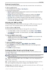
Страница 43: ...radar Avoid looking directly at the radar because the eyes are the most susceptible part of the body To turn on the radar 1 When you power the network on the radar warms up A countdown is provided to alert you when the radar is ready From the Home screen select Radar Cruising for Cruising mode or select Radar Sentry for Sentry mode See page 40 for more information on Cruising and Sentry modes NOTE...

Страница 44: ...djust the zoom scale Using Sentry Mode Sentry mode allows you to put the radar antenna into timed transmit mode in which you can configure a transmit standby cycle You can also enable a guard zone in Sentry mode which identifies a safe zone around your boat An alarm sounds when a radar object enters this zone You can place the radar in Sentry mode by selecting Radar Sentry NOTE When Sentry mode is...

Страница 45: ... size Corner 1 Corner 2 Circular Radar Targeting Use the ROCKER GPSMAP 4000 series or touch the target location GPSMAP 5000 series to begin targeting As you move the target over objects on the radar target options appear along the right side of the screen Cruising Screen Targeting Heading line Target options Target To stop targeting select Stop Pointing Create Waypoint marks a waypoint at the targ...

Страница 46: ... series or the and keys GPSMAP 5000 series to zoom in and out Zooming while panning the map only affects the zoom scale of the map The radar range remains the same Zooming while the map is locked on the boat not panning affects the zoom scale of the map and the radar range To access additional settings or options for the radar overlay screen select Menu Select Setup Chart Setup to access the chart...

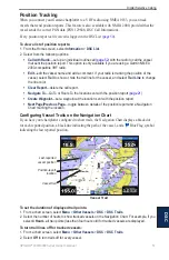
Страница 47: ... the Radar screen select Menu Show VRM EBL If the VRM and EBL are shown from the Radar screen select Menu Adjust VRM EBL Hide VRM EBL To select the VRM EBL target location GPSMAP 4000 series On the Radar screen use the ROCKER to move the pointer to the VRM EBL target location and select Drop VRM EBL GPSMAP 5000 series On the Radar screen touch the target location and select Drop VRM EBL To adjust ...

Страница 48: ...ess advanced radar settings from the Radar screen select Menu Radar Setup Rotation Speed GMR 18 24 404 406 series models only set the rotation speed of your radar to Normal Speed or High Speed High Speed increases the speed at which the antenna rotates which increases the speed at which the screen updates Front of Boat offset the front of the boat if you mount the radar at an angle Data Bars show ...

Страница 49: ... from the transducer The range scale along the right side of the screen shows the depth of detected objects as the screen scrolls from the right to the left From the Home screen select Sonar Full Screen Suspended target Bottom Depth temperature and water speed GPS speed and GPS heading Transducer frequency Range Understanding the Split Zoom Screen Use the Split Zoom screen to view the full sonar d...

Страница 50: ...lit Frequency Depth temperature and water speed GPS speed and GPS heading Transducer frequencies Range Understanding the Temp Log If you are using a temperature capable transducer the Temp Log screen keeps a graphic log of temperature readings over time The current temperature and depth are shown in the upper left corner From the Home screen select Sonar Temp Log Temperature and depth Time elapsed...

Страница 51: ...dium or Slow If using a speed capable transducer select Auto to have the scroll speed automatically adjust to the water speed of your boat Whiteline highlights the strongest signal from the bottom to help identify its hardness or softness Off default Whiteline is disabled High the most sensitive setting Almost all strong returns are highlighted in white Medium many strong returns are highlighted i...

Страница 52: ...o a section of the Full Screen The zoom is off or set to No Zoom by default Four options are available 2x Zoom twice the magnification Select Up Down or Auto to set the depth range of the magnified area 4x Zoom four times the magnification Select Up Down or Auto to set the depth range of the magnified area Bottom Lock locks the zoom window to the bottom Select Up Down or Auto to set the depth rang...

Страница 53: ...ou initiate a man overboard distress call from your radio the chartplotter displays the man overboard screen and prompts you to navigate to the man overboard point page 50 X When you initiate a man overboard distress call from your chartplotter the radio displays the Distress Call page to initiate a man overboard distress call page 50 X To turn DSC on or off 1 Select Configure Other Vessels 2 Sele...

Страница 54: ...essel and select Trail Line to change the line color Clear Report delete the call report Navigate To Go To or Route To the position sent with the distress call page 21 The symbol marks the position of the vessel on the Navigation Chart at the time a DSC distress call is sent Create Waypoint set a waypoint at the position sent with the distress call Next Page Previous Page toggle between details re...

Страница 55: ... line color Clear Report delete the call report Navigate To Go To or Route To the location sent with the position report page 21 Create Waypoint set a waypoint at the location sent with the position report Next Page Previous Page toggle between details of the position report and a Navigation Chart marking the location Configuring Vessel Trails on the Navigation Chart If you have your chartplotter ...

Страница 56: ... channel is limited to those channels that are available in all frequency bands 6 8 9 10 13 15 16 17 67 68 69 71 72 73 or 77 NOTE The default channel is 72 However select Channel to select a different channel from the list If you select a different channel the chartplotter will use that channel for subsequent calls until you call using a different channel To make an individual routine call 1 While...

Страница 57: ... W 184 3 245 8 mm GPSMAP 5008 5 H 6 73 W 128 2 170 9 mm GPSMAP 5012 7 11 H 9 3 W 180 49 235 97 mm GPSMAP 5015 8 98 H 11 97 W 228 1 304 1 mm Case Fully Gasketed high impact plastic and aluminum alloy waterproof to IEC 529 IPX Temp Range from 5 to 131 F from 15 to 55 C Compass Safe Distance GPSMAP 4008 5008 2 6 ft 80 cm GPSMAP 4012 5012 3 3 ft 1 m GPSMAP 4010 3 3 ft 1 m GPSMAP 5015 1 3 ft 40 cm Hg l...

Страница 58: ...reen Capturing Screenshots You can capture a screenshot of any screen displayed on your unit as a bitmap BMP file and then transfer it to your computer Note To capture screenshots on the GPSMAP 5000 series you need the optional Garmin RF Wireless Remote Control To capture screenshots 1 Insert an SD card into the SD card slot on the front of the unit 2 Select Configure System Beeper Display 3 Selec...

Страница 59: ...port Cooling Fan Voltage Too Low the cooling fan voltage is lower than expected Contact product support Database Error general database error Contact Garmin Product Support Deep Water Alarm sonar the boat has entered user defined value for deep water Directory Item With This MMSI Already Exists the MMSI unit is already in directory Directory Memory is Full Can t Create Entry DSC directory is full ...

Страница 60: ...routes to make room Route Truncated some points on the end of the route have been discarded Shallow Water Alarm sonar the boat has entered the user defined shallow water depth Simulating Operation the unit is in Simulator Mode Sonar Failed Unit Needs Repair there has been a sonar failure and the unit needs to be sent in for repair Contact Garmin Product Support Sonar Service Incompatible Software ...

Страница 61: ... your Garmin product www garmin com Software License Agreement BY USING THE UNIT YOU AGREE TO BE BOUND BY THE TERMS AND CONDITIONS OF THE FOLLOWING SOFTWARE LICENSE AGREEMENT PLEASE READ THIS AGREEMENT CAREFULLY Garmin grants you a limited license to use the software embedded in this device the Software in binary executable form in the normal operation of the product Title ownership rights and int...

Страница 62: ...ies chartplotter to optional NMEA 0183 compliant devices see the GPSMAP 4000 5000 Series Installation Instructions Approved NMEA 0183 Sentences GPBWC GPRMC GPGGA GPGSA GPGSV GPGLL GPBOD GPRMB GPRTE GPVTG GPWPL GPXTE and Garmin proprietary sentences PGRME PGRMM and PGRMZ This unit also includes support for the WPL sentence DSC and sonar NMEA 0183 input with support for the DPT depth or DBT MTW wate...

Страница 63: ...conformity 57 delete all 30 delete a waypoint 24 30 depth line 48 detail 10 device list 34 DSC 30 36 43 49 E EBL 43 edit a route 26 edit existing waypoint 24 engine gauges 30 F factory settings restoring 4 fish eye 3D 6 16 settings 16 fishing charts 16 fish symbols 47 frequency 48 FTC 43 fuel gauges 31 full screen 45 G gain 48 gauges engine 30 fuel 31 GMR 18 37 39 GMR 21 41 37 GMR 404 406 37 39 go...

Страница 64: ...tion chart 6 sonar 47 sonar advanced 48 system 32 simulator mode 4 32 soft keys i 1 sonar 45 48 a scope 48 color scheme 47 depth line 48 fish symbols 47 frequency 48 full screen 45 gain 48 range 48 scroll speed 47 split frequency screen 46 split zoom screen 45 surface noise 47 temp log 46 whiteline 47 zoom 48 sonar cone 16 specifications 53 split frequency screen 46 split zoom screen 45 spot depth...

Страница 65: ......

Страница 66: ......

Страница 67: ......

Страница 68: ...m 2009 Garmin Ltd or its subsidiaries Garmin International Inc 1200 East 151st Street Olathe Kansas 66062 USA Garmin Europe Ltd Liberty House Hounsdown Business Park Southampton Hampshire SO40 9LR UK Garmin Corporation No 68 Jangshu 2nd Road Shijr Taipei County Taiwan www garmin com April 2009 Part Number 190 01077 00 Rev B Printed in Taiwan ...

Отзывы: