4-79
190-01150-02 Rev. J
Garmin G500H Pilot’s Guide
For
ewor
d
Sec 1
System
Sec 2
PFD
Sec 3
MFD
Sec 4
Hazar
d
Avoidance
Sec 5
Additional
Featur
es
Sec 6
Annun.
& Alerts
Sec 7
Symbols
Sec 8
Glossary
Appendix A
Appendix B
Index
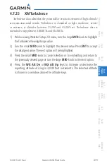
4.7.25 XM Turbulence
Turbulence data identifies the potential for erratic movement of high-altitude
air mass associated winds. Turbulence is classified as light, moderate, severe
or extreme, at altitudes between 21,000 and 45,000 feet. Turbulence data is
intended to supplement AIRMETs and SIGMETs.
1) While viewing Weather Setup 2/2 menu, turn the large
MFD
knob to highlight
the Turbulence Viewing Range value.
2) Turn the small
MFD
knob to highlight the desired value. Press
ENT
to accept
the displayed value. The next option will be highlighted.
3) Press the small
MFD
knob to cancel selection or to end editing and return to
the previously viewed page or turn the large
MFD
knob to the next option.
4) Press the
WX Alt Dn
or
WX Alt Up
keys to increase or decrease the
reporting altitude of icing in 3,000 foot increments. The selected altitude
is shown in a window above the altitude keys.
Содержание G500H
Страница 1: ...G500H Pilot s Guide ...
Страница 365: ......

