


3
Select
Tides
,
Currents
, or
Celestial
.
Sonar
When properly connected to an optional Garmin sounder
module and a transducer, your compatible chartplotter can be
used as a fishfinder. There are different sonar views to help you
view the fish in the area.
The adjustments you can make to each sonar view vary
depending on the view you are in and the chartplotter model,
sounder module, and transducer you have connected.
Sonar Views
The sonar views available vary depending on the type of
transducer and optional sounder module connected to the
chartplotter. For example, you can view the Garmin ClearVü
screen only if you have a Garmin ClearVü transducer
connected.
There are four basic styles of sonar views available: a full-
screen view, a split-screen view that combines two or more
views such as Traditional and Garmin ClearVü, a split-zoom
view, and a split-frequency view that displays two different
frequencies. You can customize the settings for each view in the
screen. For example, if you are viewing the Split Frequency
view, you can adjust the gain for each of the frequencies
separately.
If you do not see an arrangement of sonar views to suit your
needs, you can create a custom Combination screen (
Full-Screen Sonar View
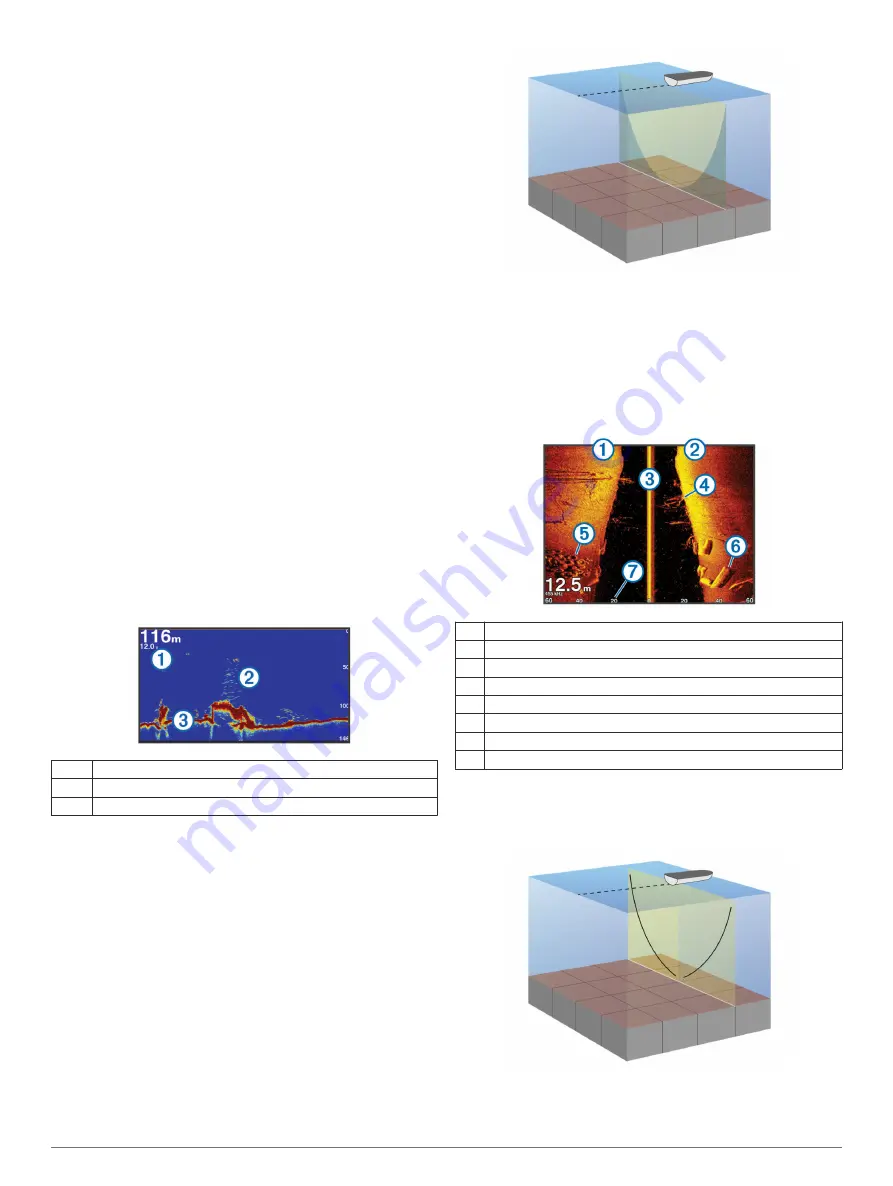
There are several full-screen views available, depending on the
equipment connected. The full-screen sonar views show a large
image of the sonar readings from a transducer. The range scale
along the right side of the screen shows the depth of detected
objects as the screen scrolls from the right to the left.
À
Depth information
Á
Suspended targets or fish
Â
Bottom of the body of water
Garmin ClearVü Sonar View
NOTE:
To receive Garmin ClearVü scanning sonar, you need a
compatible chartplotter or fishfinder and a compatible
transducer.
Garmin ClearVü high-frequency sonar provides a detailed
picture of the fishing environment around the boat in a detailed
representation of structures the boat is passing over.
Traditional transducers emit a conical beam. The Garmin
ClearVü scanning sonar technology emits two narrow beams,
similar to the shape of the beam in a copying machine. These
beams provide a clearer, picture-like image of what is beneath
the boat.
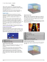
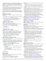
SideVü Sonar View
NOTE:
Not all models provide built-in SideVü sonar support. If
your model does not provide built-in SideVü sonar, you need a
compatible sounder module and compatible SideVü transducer.
If your model does provide built-in SideVü sonar, you need a
compatible SideVü transducer.
SideVü scanning sonar technology shows you a picture of what
lies to the sides of the boat. You can use this as a search tool to
find structures and fish.
À
Left side of the boat
Á
Right side of the boat
Â
The transducer on your vessel
Ã
Trees
Ä
Old tires
Å
Logs
Æ
Distance from the side of the boat
Ç
Water between the vessel and the bottom
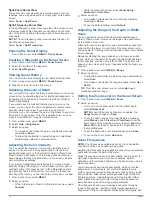
SideVü Scanning Technology
Instead of a more common conical beam, the SideVü transducer
uses a flat beam to scan the water and bottom to the sides of
your boat.
Sonar
13
Содержание AQUAMAP 80 Series
Страница 1: ...AQUAMAP 80 100 Series Owner s Manual November 2016 Printed in Taiwan 190 01657 00_0C...
Страница 6: ......
Страница 35: ......