


Ignis Operations Manual (DJI M600 Variant)
Drone Amplified
option for that camera displayed. The app knows the advertised field of view for many
DJI cameras, and will use those if you pick that camera. However, some cameras may
have variations in lenses, models, or optical zoom, and so if the app’s field of view
values are inaccurate, you should use the Custom Parameters option.
Horizontal Field of View
This displays the left-right field of view measurement of the
camera. This is only used to estimate how much area the photos will cover, and affects
the amount of overlap between transect lines. If the Custom Parameters option is
selected, there will be a slider that you can use to adjust this.
Vertical Field of View
This displays the top-bottom field of view measurement of the
camera. This is only used to estimate how much area the photos will cover, and affects
the amount of overlap along the same transect line. If the Custom Parameters option
is selected, there will be a slider that you can use to adjust this.
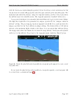
Figure 105: After you generate waypoints, the app will simulate where photos might be
taken along the waypoint mission, and how much area they’ll cover (white rectangles). In
this figure, the differently sized rectangles are due to differences in terrain elevation.
Once you’ve specified the quantities you are constrained by, touch the Generate Way-
points button. While the Mapping usage is selected, the app will simulate points at which
photos might be taken during the mission, and will draw translucent white rectangles un-
derneath those points that show an estimate of the area the photos will cover, as shown
in Figure 105. The app assumes the camera will be pitched 90 degrees downward, and the
drone will turn to face the direction of travel. These locations are only estimates, and your
Last Updated March 12, 2020
Page 120


