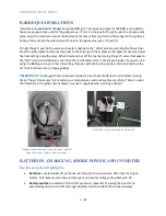


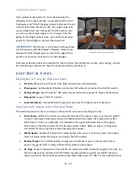


Interlude
Owners’ Notes
17
–
42
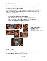
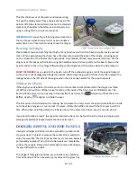
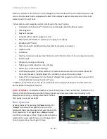
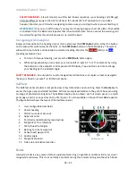
•
Press the MFD’s
Home
button (above the rotary control knob) to call up the application
selection panel.
•
Select
Charts
if they are not already displayed. The standard chart panel is shown in the diagram
above.
By default, the boat’s position is displayed a
t the center of the chart with North up
(towards the top of page). These defaults may have been changed by the last user, or you may
want to use different settings. Several options are available (see below).
•
Pan and Zoom
the display by swiping/pinching with your fingers, just like smart devices, or
rotate the control knob to zoom in/out.
4
•
Tap on the Chart to position the cursor at a location. Select
Clear Cursor
to remove the cursor.
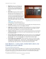
•
To access the
Systems Control
dialog panel, tap the
Power
button quickly (works on any page).
From the dialog panel, you can adjust screen brightness, adjust split screen displays, change
what’s
shown on the instrument display bar, access system settings, turn the system off, etc.
•
You can display multiple pages at a time. Press the
Home
key to get to the Apps page, press and
hold the
Charts
icon to display the multi-screen presentations available.
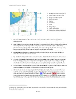
•
We like to see where we are going on the Chart display (not just where we are) and then we
switch from the default “
North Up
” display to “
Heading Up
” or “
Course Up
.” Extension lines
from the boat’s icon show you which is which –
blue
is your heading,
dark red
is your course
over ground (COG) (sailing laylines are shown in
green
and
red
). To change this display option,
tap the
Menu
key in the upper left of the Chart display and select the
Orientation
menu item.
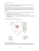
4
To select any item shown on the Zeus MFD, tap the item on the screen or select it with the rotary knob and press
the knob button to activate it.
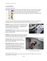
Chart page layout.
1 MOB (Man Over Board) mark
2 Vessel with extension lines
3 Waypoint with Laylines
4 North indicator
5 Route
6 Grid lines
7 Track
8 Range rings
9 Chart range scale
10 Range rings interval (optional)


