background image

A-Rival 2.5 Usermanual


33 


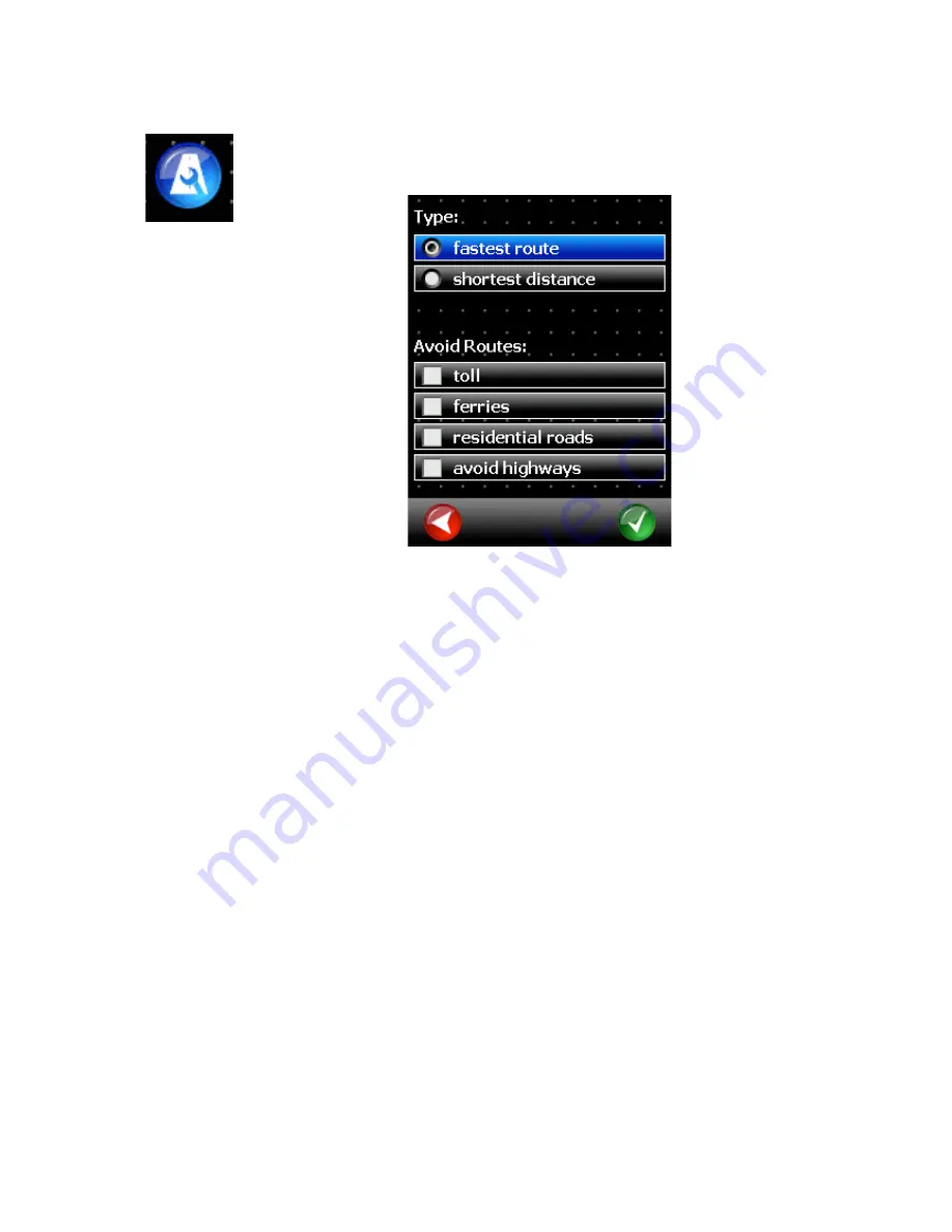
5.5  Route Settings 


The Route Settings menu allows you to specify whether to calculate the shortest or 
fastest route. 

Use avoid routes to indicate any toll roads, ferries, residential roads or highways to be 
avoided during route calculation. Please note that even when checked these roads may 
not be excluded from route calculation completely. 

“Avoid highways” may be used to calculate small scale detours only. The option is not 
suitable when calculating long distance routes. 


Содержание NAV-PNX 35 M

Страница 1: ...gationsystem A good choice We hope you ll enjoy using your new an a rival Navigationsystem Just in case that you are facing any problems with your Device please call our support service hotline 0049 0...

Страница 2: ...t 9 2 3 4 9 2 3 5 House number 10 2 4 Favorites 11 2 5 Map 12 2 6 POI 14 2 7 POI in City 15 2 8 POI Text 16 2 9 Itinerary 17 2 10 Coordinates 19 2 11 Zip Code 20 2 12 Previous Destinations 21 2 13 Sta...

Страница 3: ...Road 41 6 1 Travel Information 41 6 2 Zoom 43 6 3 Driving Instruction Volume 44 6 4 Itinerary 45 6 5 Options 46 6 5 1 Mute 46 6 5 2 Map View 46 6 5 3 Night Mode 46 6 5 4 Interstations 46 6 5 5 Block...

Страница 4: ...o start navigation 2 Route Planning Here you can plan the route to check the distance and approximate travel time 3 Position Indicates your current GPS position on the map 4 Options Here you can defin...

Страница 5: ...shields heat insulating windshields may adversely affect GPS reception Navigation can only take place if a valid GPS signal is received After setting up the device for the first time or after travelin...

Страница 6: ...ver if the GPS receiver has been configured correctly the route calculation will automatically start as soon as reception is back to normal During navigation the current GPS signal is indicated at the...

Страница 7: ...etailed information on how to set up your office address 2 3 Address 2 3 1 City You can enter the destination address here Enter the city name using the screen keyboard As soon as you enter the first...

Страница 8: ...enter O instead of enter U For example if your destination is located in K ln Germany just enter K O L N You do not need to enter spaces and hyphens Instead simply click the empty field to the left o...

Страница 9: ...where the street is being searched Alternatively you can select DOWNTOWN if you want to drive to the center of the respective city In this example R O T E was entered If the desired street is displaye...

Страница 10: ...er Next you are requested to enter the house number Enter the house number and confirm by pressing the GREEN button If you do not know the house number click the GREEN button without making an entry I...

Страница 11: ...on to the chosen intersection 2 4 Favorites Favorites are frequently used addresses you can store in a list This facilitates quick access to these destinations When you start up the system for the fir...

Страница 12: ...can use the plus and minus Buttons to zoom in and out Alternatively you can use the magnifying glass If you draw a box around the target form the upper left to the lower right blue the map viewer zoo...

Страница 13: ...circle to select a destination by directly clicking into the map A shortcut menu now offers the following options Search nearest address Displays a list of addresses at the selected location that you...

Страница 14: ...sites such as gas stations hotels or hospitals The POIs are grouped into separate categories After calling up the POI function you must select the desired category The list first indicates the top ca...

Страница 15: ...d on the map 2 7 POI in City The POI in City function serves to find a POI located far from your present location This function can be very useful for example when you are looking for a hospital in an...

Страница 16: ...2 8 POI Text The POI Text function allows you to search POIs in any one category by entering free form text First select the desired category Next enter the keyword e g Brandenburger for finding the B...

Страница 17: ...of the POI on the map Pressing the GREEN button will start navigation to the selected POI 2 9 Itinerary The Itinerary function allows you to specify several destinations you want to travel to success...

Страница 18: ...ny of the available methods for selecting a destination You can change the order of the stops using the up down buttons red circle Click the GREEN button to start navigation to the first stop Once you...

Страница 19: ...of coordinates First enter the latitude then the longitude When entering the latitude please select N for North or S for South Respectively please select W for East or W for West when entering the lon...

Страница 20: ...nables you to define your destination by entering a zip code This is what the screen looks like after entering 51373 After selecting the first entry you can search for a street within the zip code are...

Страница 21: ...a the map cf Chapter 2 5 are indicated in the form of coordinates For example when you select the name of a city from the list a new screen will show the street names previously entered for this city...

Страница 22: ...ou wish to discard 2 13 Start Navigation After you have selected a destination you can specify the driving mode that is to apply for the route cf Chapter 5 6 If you don t want this query to appear eac...

Страница 23: ...ck the BLUE button to start navigation 2 14 Alternative Routes After the initial route calculation a similar screen to the one below will appear The calculated route can be accepted by pressing the bl...

Страница 24: ...ration ahead of time The Route Planning function works much the same as entering a normal destination the only difference is that you must indicate a start location in addition to the destination You...

Страница 25: ...ear each time route calculation and navigation are launched deselect the checkmark in the Ask before every route calculation field Press the GREEN button to start route calculation After calculation t...

Страница 26: ...button allows you to move the displayed map section Press the selection button red circle to select destinations on the map and start navigation First click the selection button and then click any lo...

Страница 27: ...rites Favorites are frequently used addresses you can store in a list This facilitates quick access to these destinations When you start up the system for the first time the favorites list is empty Cl...

Страница 28: ...do so please refer to Chapter 2 After selecting an address e g by entering the address see Chapter 2 2 you will be prompted to provide a name for this favorite Confirm your entry with the GREEN butto...

Страница 29: ...Deleting favorites To delete a favorite mark the entry in the list and click the trash can icon red circle 5 1 3 Renaming favorites If you want to rename a favorite mark the entry in the list and cli...

Страница 30: ...ume The volume menu allows you to adjust the system volume If you want to change the system volume during navigation please refer to Chapter 6 3 Tap Button click sounds activate or deactivate the feed...

Страница 31: ...riving Direction but the view is rendered as a 3D perspective If the Show traffic signs function is enabled the map screen will display the content of traffic signs to assist you in keeping your beari...

Страница 32: ...y setting If you want to set the displayed map section manually disable the auto crossway zoom function To do so click the check mark to make it disappear The day night switch enable the day night aut...

Страница 33: ...void routes to indicate any toll roads ferries residential roads or highways to be avoided during route calculation Please note that even when checked these roads may not be excluded from route calcul...

Страница 34: ...urs outside the cities an over country roads To drive longer routes with highways please choose the bike destination probile The profile car fast shall be used for passenger cars in general The option...

Страница 35: ...must be made to allow the navigation software to read GPS data from the receiver After the first installation of the software this screen should be displayed Please click on the blue button with the m...

Страница 36: ...are receives one dataset per second Since the connection was established 91 datasets have been received Satellites Number of satellites from which signals are currently being received For a position f...

Страница 37: ...A Rival 2 5 Usermanual 37 5 9 Language In the Language menu you can select the language used to output spoken driving instructions and display texts on screen...

Страница 38: ...acoustic or visual alerts The shown example gives an acoustic alert when exceeding the speed limit by 10km h or more but but never displays a visual warning 5 11 GPS Logs Your navigation system is abl...

Страница 39: ...l 39 To finish recording click the black button To show a GPS track on a map click the green button and select a track The track will be shown on the map with a line of green dots Please open a mapvie...

Страница 40: ...displayed By first tapping the marker button red circle and then the map any road segment can be permanently blocked To unblock a segment tap it again The blockades persist even when the navigation so...

Страница 41: ...s The lane info is most common on freeways highways and big crossings 190 meters Indicates the distance remaining until the next maneuver must be carried out 10 25 Indicates the calculated arrival tim...

Страница 42: ...A Rival 2 5 Usermanual 42 With the route overview button and destination view button you can see the route and the destination on the map...

Страница 43: ...lends in automatically Optionally you can click on the overview map to blend in the bar faster 6 2 Zoom During navigation you can use the plus minus buttons red circles to enlarge or reduce the displa...

Страница 44: ...5 Usermanual 44 6 3 Driving Instruction Volume Click big arrow in the lower black bar at any time to adjust the volume of the driving instructions After a few seconds the volume display automatically...

Страница 45: ...This works by typing on the travel time or the route display red marked If the display shows the last partial route the orange route view image will be shown The partial routes are displayed with diff...

Страница 46: ...tton calls up a menu for performing map display settings cf Chapter 5 4 6 5 3 Night Mode Press the Night Mode button to display the map in a color scheme optimized for dark lighting conditions Press t...

Страница 47: ...passing the blocked section This function is useful for circumventing traffic jams or blocked roads When you have blocked a road a button Free appears in the Options Menu Use this button to free the b...

Страница 48: ...ence number 100026920 GREAT BRITAIN TMC codes The RDS TMC traffic information with TMC location table version number 6G 3 4 4 5 and 4 6 from Trafficmaster contained in this product is derived of the T...

Страница 49: ...the Software is governed by this EULA and its amendments and may be subject to additional payments and conditions This License does not imply any rights to future delivery of free or paid Service or...

Страница 50: ...ed by separate terms infoware reserves the right to discontinue Internet based services provided to you or made available to you through the use of the Software 8 LINKS TO THIRD PARTY SITES infoware i...

Отзывы: