background image

400W / 500W Series

Garmin Optional Displays
Pilot’s Guide Addendum For: 

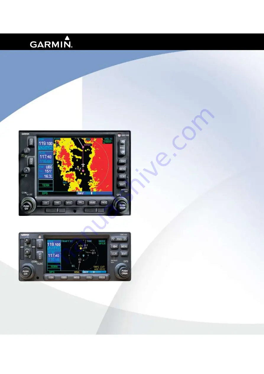
• GDL 69/69A XM Satellite Datalink
• GTX 330/330D TIS
• Garmin TAWS (GPS 500W & GNS 530W)
• Garmin HTAWS (Helicopter Installations)
• Terrain Proximity (Helicopter Installations)
• Garmin GTS 8XX Series TAS

All manuals and user guides at all-guides.com

all-guides.com

Summary of Contents for GNC 530W

Page 1: ...m For GDL 69 69A XM Satellite Datalink GTX 330 330D TIS Garmin TAWS GPS 500W GNS 530W Garmin HTAWS Helicopter Installations Terrain Proximity Helicopter Installations Garmin GTS 8XX Series TAS All man...

Page 2: ...armin hereby grants permis sion to download a single copy of this manual and of any revision to this manual onto a hard drive or other electronic storage medium to be viewed and to print one copy of t...

Page 3: ...ies Unit package Pilots using an out of date database do so entirely at their own risk CAUTION The Weather Data Link TIS TAWS HTAWS and TERRAIN information contained in this Pilot s Guide Addendum is...

Page 4: ...19 TFR Information 19 Lightning LTNG 20 Cell Movement CELL MOVE 21 Winds Aloft 22 WindsAloftAltitude 23 Section 3 XM AUX Pages 23 XM Information Page 23 XM WX Timestamps 24 Section 4 XM Audio 25 XM A...

Page 5: ...TAWS Failure Alert 56 HTAWS Alert Summary 56 Pilot Actions 57 Voice Call Out Selection 58 Part Five Terrain Proximity Interface 59 Introduction 59 Displaying Terrain Proximity 59 Terrain Proximity 120...

Page 6: ...iv Introduction Table of Contents This page intentionally left blank 190 00356 30 Rev H All manuals and user guides at all guides com a l l g u i d e s c o m...

Page 7: ...feet above the requesting aircraft The TIS is a ground based service that displays nearby aircraft on your 400W 500W series display For the TIS feature to inform you of a nearby aircraft s presence se...

Page 8: ...ation may be intermittent during turns or other maneuvering TIS is dependent on two way line of sight communication between the aircraft and the Mode S radar Whenever the structure of the client aircr...

Page 9: ...cility By FAA Form 8000 7 Safety Improvement Report a postage paid card designed for this purpose These cards may be obtained at FAA FSSs General Aviation District Offices Flight Standards District Of...

Page 10: ...ly reduces the nuisance alerting due to proximate aircraft For example when the first Traffic Advisories appears on the TIS display the user is alerted audibly So long as a single aircraft remains on...

Page 11: ...icate that traffic has been removed from the display due to the age of the data being too old to coast for the time period after 12 seconds from the last receipt of a TIS message The pilot should be a...

Page 12: ...30 knots or when an approach is active Traffic Page TIS Traffic data are displayed on two 400W 500W Series unit pages the Traffic Page and the Map Page The 500W Series unit can also be configured to...

Page 13: ...played on the Map Page TA PA Only traffic advisories and proximity advisories are displayed on the Map Page TA only Only traffic advisories are displayed on the Map Page From the Map Page you can disp...

Page 14: ...ce to the pointer from your present position Displaying traffic range and altitude separa tion using the Map Panning feature To activate the panning feature and pan the map display 1 Press the small r...

Page 15: ...aller for detailed criteria information traffic is displayable on the Traffic Page in oper ating mode If the system fails the power up test the NO DATA DATA FAIL or FAILED message is displayed See you...

Page 16: ...determined by system configuration at the time of installation the system switches from standby mode to operating mode The 400W 500W Series unit displays OPER in the upper right hand corner of the dis...

Page 17: ...te and independent from Garmin Corporation Have your radio hardware IDs ready before contact ing XM Satellite Radio During the process you can select services for subscription Keep in mind that the GD...

Page 18: ...METARs symbols METAR Lightning LTNG Cell Movement CELL MOVE and Winds Aloft WINDS are displayed on the NAV pages The types of products available depend on the subscription service with XM Satellite Ra...

Page 19: ...In the 500W series TFR boundaries are also shown on the NAV main page You can obtain more information about a TFR by bringing up the map cursor moving the map cursor to within the yellow outlined area...

Page 20: ...st press MENU again to exit the Page Menu NOTE US and Canadian radar may not be displayed simultaneously To display NEXRAD weather on the XM Weather page 1 With the XM Weather page the third page of t...

Page 21: ...Intensity Legend 1 While viewing the XMWeather page press the MENU key to display the Page Menu 2 Turn the large or small knob to select Display legend 3 Press ENT to display the NEXRAD Intensity Leg...

Page 22: ...s directly over the site Neither NEXRAD weather data nor the age of the NEXRAD weather data are displayed at a zoom range of less than 10 NM The resolu tion of displayed NEXRAD data is 2 kilometers Th...

Page 23: ...ove a certain severity level If there are no colored flags visible you may have to search a wider area zoom out with the RNG key before you see some METAR flags To display the METAR Legend 1 Press the...

Page 24: ...ht an airport with a METAR flag 4 Press ENT to display the METAR text With Done highlighted press ENT to return to the map view To view any airport s Textual METAR page 1 If not viewing theWPT page gr...

Page 25: ...icular airport The format is similar to that used for METARS but describes a weather forecast rather than current weather at the particular airport TFR Information Areas with TFRs Temporary Flight Res...

Page 26: ...he TFR Information page is sufficient to let you comply with the Temporary Flight Restriction by avoiding the affected area Active Time This field is for the beginning and ending times of the temporar...

Page 27: ...If another weather product rather than CELL MOVE is shown press the small right CRSR knob to highlight the product name such as NEXRAD Turn the small right knob to change to CELL MOVE and press that...

Page 28: ...hich the wind is coming Barbs which are used singly and in combinations have the following values A short line 5 knots A long line 10 knots A pennant triangle 50 knots For example a vertically oriente...

Page 29: ...X page group Here we discuss the two pages that are inserted regardless of whether the XM receiver is a GDL 69 or GDL 69A XM Information Page This page contains information that you will use when acti...

Page 30: ...ypical values would be Avia tor LT or Aviator Currently the 400W and 500W series only support a subset of the Avia tor LT service from XM Satellite Radio Product Aviator LT Aviator US NEXRAD CN NEXRAD...

Page 31: ...satellites coverage far exceeds land based transmissions When enabled the XM Satellite Radio audio entertainment is accessible in the AUX function The information on the XM Satellite Radio display is...

Page 32: ...title 3 Press ENT to select the highlighted category The first channel in the selected category will now be highlighted and the current song being played in that channel will be shown in the lower wi...

Page 33: ...fifteen channels may be saved as presets to easily return to your favorite channels 1 While viewing the XM Audio page selected the desired channel 2 While the desired channel is highlighted press the...

Page 34: ...e small right knob to select a number 3 Press the ENT key to make a selection The selected channel will now play and is dis played in the window at the bottom of the display Display Channel In List Ch...

Page 35: ...ey Turn the large right knob to highlight Display Artist In List 2 Press the ENT key Display Title In List The Titles of the songs in the range of displayed channels can be shown in the middle pane by...

Page 36: ...t or Disable Audio Output 2 Press the ENT key to perform the highlighted action Pressing the CLR key toggles the audio output Change Volume The XM Audio volume may be changed in two ways directly with...

Page 37: ...e Terrain page and checking the upper left corner for TAWS Operating Criteria Garmin TAWS requires the following to operate properly The system must have a valid 3D GPS position solution The system mu...

Page 38: ...conditions Detailed alert modes are described later in this section Baro Corrected Altitude Baro corrected altitude or indicated altitude is de rived by adjusting the altimeter setting for local atmo...

Page 39: ...This is the only orientation available for the TAWS Page To display a 120 view 1 Select theTAWS Page and press MENU Select View 120 2 Press ENT The TAWS Page displays the 120 view To change to a 360 v...

Page 40: ...d in the terrain annunciator field whenever TAWS is inhibited To enable PDA and FLTA alerts 1 Select the TAWS Page and press MENU Enable Terrain is selected by default 2 Press ENT The PDA FLTA alerts...

Page 41: ...pages but not on the TAWS page NOTE Ifanobstacleandtheprojectedflightpath of the aircraft intersect the display automatically zooms in to the closest potential point of impact on the TAWS Page Unligh...

Page 42: ...obstacle data bases comes from government agencies Garmin accurately processes and cross validates the data but cannot guaran tee the accuracy and completeness of the data The terrain obstacle databa...

Page 43: ...nsert the new card into the right most slot of the 500W Series unit 4 Turn on the 500W Series unit and verify that the TAWS system passes self test Terrain Obstacle Database Areas of Coverage The foll...

Page 44: ...system For a summary of aural messages see the TAWS Alert Summary table NOTE TAWS Caution Alerts are displayed as constant black text on a yellow background TAWS Warning Alerts are displayed as const...

Page 45: ...hase of flight FLTA alerts are automatically inhibited when the aircraft is below 200 feetAGL while within 0 5 NM of the approach runway or is below 125 feetAGL while within 1 0 NM of the runway Prema...

Page 46: ...e Loss After Takeoff is to provide suitable alerts to the pilot when the system determines that the aircraft is losing altitude closing upon terrain after takeoff The aural message Don t Sink is given...

Page 47: ...Alerts EIGHT BOVE 4ERRAIN EET LTITUDE OSS EET h 4 3 v h 4 3 v Negative Climb Rate NCR Alert Criteria EIGHT BOVE 4ERRAIN EET 3INK 2ATE EET 0ER INUTE h 4 3 v h 4 3 v 190 00356 30 Rev H All manuals and u...

Page 48: ...the annunciation window When the GPS signal is re established and the aircraft is within the database coverage area the TER N A annunciation is removed TERRAIN NOT AVAILABLE Display Position Outside T...

Page 49: ...Ahead Pull Up Forward Looking Terrain Avoidance Warning for Terrain or Obstacle Ahead Obstacle Ahead or Caution Obstacle Caution Obstacle Forward Looking Terrain Avoidance Caution for Obstacle or Obst...

Page 50: ...t factor Reference FAR 91 223 A TAWS caution indicates terrain or obstacle nearby If possible visually locate the terrain or obstacle for avoidance A TAWS warning may follow a TAWS caution unless the...

Page 51: ...ystem must have a valid 3D GPS position solution The system must have a valid terrain obstacle database Limitations NOTE The data contained in the terrain and obstacle databases comes from government...

Page 52: ...terrain conditions Detailed alert modes are described later in this section Baro Corrected Altitude Baro corrected altitude or indicated altitude is de rived by adjusting the altimeter setting for loc...

Page 53: ...in on all sides 120 View View of terrain ahead of and 60 to either side of the aircraft flight path NOTE The HTAWS Page gives a Track Up display orientation as indicated by the TRK label shown on the...

Page 54: ...tion This indicates that HTAWS is no longer providing CFIT protection This automatic TAWS INHB cannot be removed by menu option selection In fact the menu option can still list the Inhibit HTAWS optio...

Page 55: ...hen an HTAWS Caution occurs the Mute Active Caution selection will be available on the Page Menu NOTE 1 Selecting this only mutes the caution that is presently active if the caution goes away then the...

Page 56: ...ails the test NOTE HTAWS System Testing is disabled when ground speed exceeds 30 knots so as not to impede HTAWS alerting HTAWS Legend 1 Select the HTAWS Page and press MENU Turn the large or small ri...

Page 57: ...he HTAWS Page Terrain more than 500 ft below the aircraft altitude Terrain is between 0 ft and 250 ft below the aircraft altitude Terrain is more than 250 ft above the aircraft altitude Terrain is bet...

Page 58: ...usive Pilots must familiarize themselves with the appropri ate charts for safe flight NOTE The data contained in the terrain and obstacle data bases comes from government agencies Garmin accurately pr...

Page 59: ...vailable from Garmin Con tact Garmin at 800 800 1020 or at www garmin com for more information To update your terrain obstacle databases 1 Acquire a new terrain data card from Garmin 2 Turn off the po...

Page 60: ...software algorithms HTAWS alerts employ either a CAUTION or a WARNING alert severity level When an alert is issued visual annunciations are displayed Aural alerts are simultaneously issued Annunciatio...

Page 61: ...tion Terrain OR Terrain Ahead Terrain Ahead Similarly a Caution Obstacle Caution Obstacle or Obstacle Ahead Obstacle Ahead alert is also provided The time to an alert can vary with conditions therefor...

Page 62: ...AILABLE Display Position Outside Terrain Database Coverage No GPS Position HTAWS Failure Alert HTAWS continually monitors several system critical items such as database validity hardware status and GP...

Page 63: ...nnunciation Pop Up Alert Aural Message Description None HTAWS System Failure HTAWS has failed None None HTAWS has been inhibited by the crew or the aircraft groundspeed has fallen below 30 knots autom...

Page 64: ...all outs can be enabled and disabled through the Voice Call Out Selection option on the AUX SETUP 2 page To select the Voice Call Out choices in the Setup 2 page select the Voice Call Out Selection it...

Page 65: ...rmation displayed for those locations The Terrain legend shown in the lower right of the display on the Terrain Page defines the color black as 500 ft However this does not apply to the black cutouts...

Page 66: ...60 This page intentionally left blank Part Four Section 3 190 00356 30 Rev H All manuals and user guides at all guides com a l l g u i d e s c o m...

Page 67: ...in coloring that depicts terrain eleva tion relative to the aircraft GPS MSL altitude accuracy is affected by factors such as satellite geometry but it is not subject to variations in pressure and tem...

Page 68: ...ween the two selections 120 View Selected Terrain Proximity Aviation Data Select the display of Aviation data on the Terrain Proximity page The Page Menu selections allow you to hide or show aviation...

Page 69: ...wo selections Terrain Legend Shown in Lower Right Corner Terrain more than 500 ft below the aircraft altitude Terrain is between 0 ft and 250 ft below the aircraft altitude Terrain is more than 250 ft...

Page 70: ...e data contained in the terrain and obstacle databases comes from government agencies Garmin accurately processes and cross validates the data but cannot guarantee the ac curacy and completeness of th...

Page 71: ...Description Please refer to the GTS 8XX Series Pilot s Guide for a complete description of the GTS 8XX Series Traffic system Traffic Page showing GTS 8XX series traffic near the 40 NM mile range at 1...

Page 72: ...de for informa tion on voice announcements Switching Between Standby and Operating Modes The unit must be in operating mode for traffic to be displayed The ability to switch out of standby into operat...

Page 73: ...ht the current mode and turn the small right knob to cycle through the options 2 With each turn of the knob the screen changes to display the traffic detected within the selected altitude display rang...

Page 74: ...24 NM and 40 NM TAS Symbol Traffic Type Description Other Traffic Symbol The hollow white may be configured as cyan diamond represents traffic detected within the selected display range that does not...

Page 75: ...The traffic symbol is the symbol used to depict the type of traffic NOTE Proximity Advisories PA are displayed as solid white diamonds may be configured as cyan The GTS 800 shows these PAs as other h...

Page 76: ...right or turn it counterclockwise to move left 4 To cancel the panning function and return to your present position press the small right knob When the target pointer is placed on traffic the traffic...

Page 77: ...All manuals and user guides at all guides com...

Page 78: ...AT Inc 2345 Turner Rd S E Salem Oregon 97302 U S A Garmin Europe Ltd Liberty House Bulls Copse Road Hounsdown Business Park Southhampton SO40 9RB U K Garmin Corporation No 68 Jangshu 2nd Road Shijr T...

Reviews: