MY CIRCUIT
MY CIRCUIT
GeoCaChInG
TRaVeL GUIDe *
GeoCaChInG
TRaCK-ManaGeR
To provide optimum customer support, Falk has set up a service centre which
handles all aspects relating to warranty claims and repairs.
If you have any questions relating to a guarantee and warranty claim, please
contact the technical hotline:
+49 1805 - 00 32 33
(0,14
E
/ min. from a German landline,
mobile prices may vary, max 0.42
E
/ min.)
or by e-mail via our contact form:
http://www.falk-outdoor.com/en/service-en/contact.html
In the event of a technical defect occurring within the guarantee period, you
can also register the device for a free repair on the following website:
http://www.falk-outdoor.com/en/service-en/guarantee-processing.html
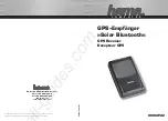
Via the function „Plan tour“ you can call up the
feature
„my circuit“
.
You can now plan a circuit either from your
current position
or from any
other point
you
want, such as a POI, a city or your home address.
As a next step, you can set your desired
parameters
. This may for example be the
desired
distance
or you can also restrict the
duration
of the circuit.
It is possible, for example, for you to enter 20 km,
or correspondingly 3 hours.
In a next step, you are asked what
activity
you
are performing. If you are out cycling and you
want to do a circuit, click on „Bicycle“; if you are
out walking, click on „Pedestrian“.
You can now select what
your circuit
should
look like. For example, if you would prefer to plan
a more sporty route, then click on „Hilly“; if you
would prefer not to climb too many hills, then
click on „Flat“.
Once you have done this, you can now stipulate
what type of routes you would mainly like to
travel on. For example, you can set it so that you
will be guided primarily along cycle paths.
Your device is equipped with an interactive travel guide. This allows you to explore a
large number of
places of interest
. Depending on the destination, lots of interesting
information may be available.
Tap on the main menu on Extras > „Travel Guide“.
You must first stipulate a search centre around which POIs are to be searched for. This
may for example be your
current location
or a
city
.
The POIs are divided up into categories. Select one of the
categories
or tap on „All
categories“ to select from a list containing all categories. If under „All categories“ you
tap on „All“ at the top, all categories are selected.
Once you have selected the category, the POIs are displayed in a list. They are sorted
according to their
distance
from your search centre.
If you tap twice on a POI in the list, you will see the
detailed
view for this POI with all
of the available information.
Click on the „OK tick“ to start the route
calculation to the selected POI.
Tip: Via the
„Sort“
button in the list with POIs
you can have the POIs sorted according to
different criteria. You can use the „ABC“
button at the bottom to enter text to search
for POIs containing this text.
* applies to LUX 32
United Navigation GmbH
Marco-Polo-Str. 1
D - 73760 Ostfildern
www.falk-outdoor.com
Changes/errors excepted
FMI-9620
FMI geocaching is a
modern form of treasure hunting
via geocoordinates.
Objects are hidden and the coordinates of the hiding place are published on the
internet. These geocaches can then be searched for by other people.
The size of the cached objects and the degree of difficulty of finding them vary.
Your device is equipped with comprehensive functionality for
paperless geo-
caching
. To transfer geocaches to your device, register on a geocaching site on the
internet (e.g. www.geocaching.com).
You can then save geocaches on your PC and transfer them to your device via the
Falk navi-Manager
software. You can obtain the Falk Navi-Manager as a free
download at:
http://www.falk-outdoor.com/en/service-en/falk-navi-manager.html
You can find further information about geocaching and operation in the
detailed user manual which is available for you to download at
http://www.falk-outdoor.com/en/service-en/manuals.html
note:
For geocaching, it is essential that under „Settings > Map display“ you should
disable the function
„Position on street“
so
that you can reach the precise location of the
geocache on all terrain. For cycling or hiking,
make sure you reactivate the function „Position
on street“.
Before using the geocaching function, you must
transfer
geocaches to your device
(e.g. from the internet portal Geocaching.com). Tap in the main menu on „Geocaching“
and select „Search for geocache“.
You must first stipulate a
search centre
around which geocaches are to be searched
for. This may for example be your current location or a POI.
If you have transferred geocaches around your current search point to the device, they
are displayed in a list sorted according
to distance
.
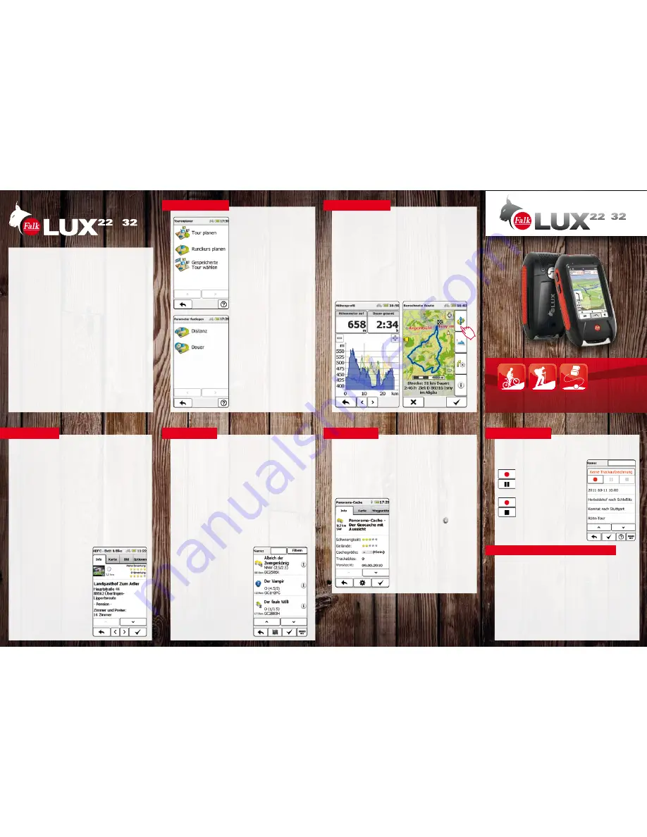
Briefly tap twice on the geocache you want to call
up the
detailed view
. There you will be shown
information about the cache and its description.
You can have the geocache or the waypoints
displayed on the map or under
„options“
add waypoints or comments or display the
instructions. Start the cache by clicking on the
„OK tick“.
Once you arrive at the cache, here you are shown
an action button via which you can perform
further actions (e.g. logging).
You can find
further information
about geocaching
and operation in the detailed user manual which is
available for you to download at
http://www.falk-outdoor.com/en/service-en.html
The Track Manager shows
all
of the tracks which exist on the device.
You can also
record your own tracks
so that you can retrace a route you have
travelled at a later date.
To do this, tap in the main menu on „Track manager“.
starts the recording
interrupts the recording
Pressing again on:
continues the recording
ends the recording and
saves the track.
You will then find the recorded tracks in the list in the
Track Manager. To view a track, tap twice on
the corresponding track.
note:
Setting the preferred transport routes means that correspondingly selected
transport routes will be given
priority
in the route calculation. For example, if „Avoid
road traffic“ is selected, the device will mainly calculate a route which tends not to run
along roads. It is of course not possible to prevent this entirely because sometimes the
use of roads is unavoidable to continue the route of a tour.
You are now ready to set off - your circuit is calculated and is shown to you on the
screen. If you click on the „Altitude profile“ button, you can now display the altitude
model for your tour. If your
favourite route
is not yet shown, you have the option of
clicking on the „Alternative routes“ button to calculate two further routes.
+
+
QUICK STaRT GUIDe
aDDITIonaL MaPS / FaLK naVI ManaGeR
Depending on the product version (LUX 22 or LUX 32), „Basic Maps Plus“ and „Premium
Outdoor Maps“ are pre-installed on the LUX.
A selection of Basic Maps Plus is already installed on the devices.
Additional maps of Europe can be uploaded to the device
free of charge
via the Falk
Navi Manager.
With the free Falk Navi Manager programme, you can manage your LUX and retrace
your recorded tracks including altitude and speed diagrams.
You will find the Falk Navi Manager at the following address:
http://www.falk-outdoor.com/en/service-en/falk-navi-manager.html
You will find additional, interesting content for your device on websites such as
www.gpsies.com, one of the biggest tour and track portals on the Internet.