24
Receiving APRS Beacons
●
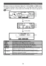
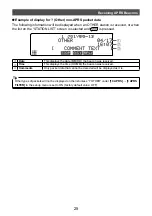
Example of a beacon information display for a G (Raw NMEA) raw NMEA station
The following information will be displayed when a raw NMEA data station (GGA/GLL
or GPRMC) is received, or when the list on the “STATION LIST” screen is selected and
is pressed.
②
③
④
⑤
⑥
⑦
⑧
⑨
①
Turn the DIAL
Turn the DIAL
➀
Distance
This displays the distance to the partner station.
➁
Date
This displays the date (MM/DD) the beacon was received.
➂
Time
This displays the time (HH:MM) the beacon was received.
➃
Speed
The movement speed of the partner station will be displayed.
➄
Direction
The movement direction of the partner station will be displayed.
➅
Altitude
The altitude of the partner station will be displayed.
➆
Latitude
The current position of the partner station will be displayed in N (northern
latitude) or S (southern latitude).
(DD degree MM.MM minute or DD degree MM minute SS second)
➇
Longitude
The current position of the partner station will be displayed in E (eastern
longitude) or W (western longitude).
(DD degree MM.MM minute or DD degree MM minute SS second)
➈
Comments
Comments, if any, from a partner station will be displayed.


