


Viewing and Navigating to a route
fwf
If you plan to navigate along the route you have just created, please return to
the main menu, then select “Tracklogs & Routes” and choose a route on the
list.
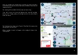
When a route is selected, the route will be displayed on the map with its
relevant information.
If you scroll down on the toolbar that appears on the left of the map, you can
also choose to navigate from where you are currently located to:
- The Starting point of the chosen route, or
- To the End point of the chosen route.
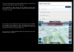
When the route is calculated to the selected point of the chosen route (either
the Starting point or the End point), the unit will plot out a navigation route to
direct you to the nearest point on the bitumen road (if the offroad point was
chosen).
Adding a route point to an existing navigation route
10


