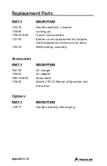


Appendix D-2
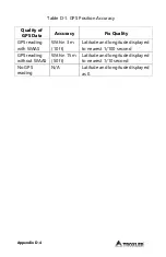
GPS Accuracy
As described earlier, the PaveTracker Plus gauge can be
equipped with an optional GPS receiver that determines the
location (latitude and longitude) of the gauge. This
information is stored with each gauge measurement. The GPS
receiver used has
Wide Area Augmentation System (WAAS)
capabilities, which provides accuracy to within 3 m (10 ft).
However, the accuracy is dependent upon the user’s location
and other factors as described below.
NOTE
The WAAS is currently functional only in the United States.
The GPS is a satellite-based navigation system that consists of
24 satellites and a network of ground stations that monitor
and control those satellites. The satellites orbit the earth at an
altitude of approximately 11,000 miles and constantly transmit
signal information back to earth. A GPS receiver uses this
information to determine its location.
To determine its latitude and longitude, a GPS receiver must
receive the signals from at least three satellites.
On average, the receiver used in the gauge is accurate to
within 15 m (approximately 50 ft) when receiving GPS data
alone. However, the WAAS capabilities can increase the
accuracy to within 3 m (10 ft), as shown in Table 1.
The accuracy of the GPS information can be affected by a
number of atmospheric forces and other conditions. The
WAAS corrects for these factors by placing the GPS receivers
at 25 known, precisely surveyed locations, called reference
stations, across the United States.
Summary of Contents for 2701-B
Page 9: ......
Page 20: ...1 8 NOTES...
Page 74: ......
Page 86: ...Appendix A 12 NOTES...
Page 92: ...Appendix B 6 NOTES...