background image

29

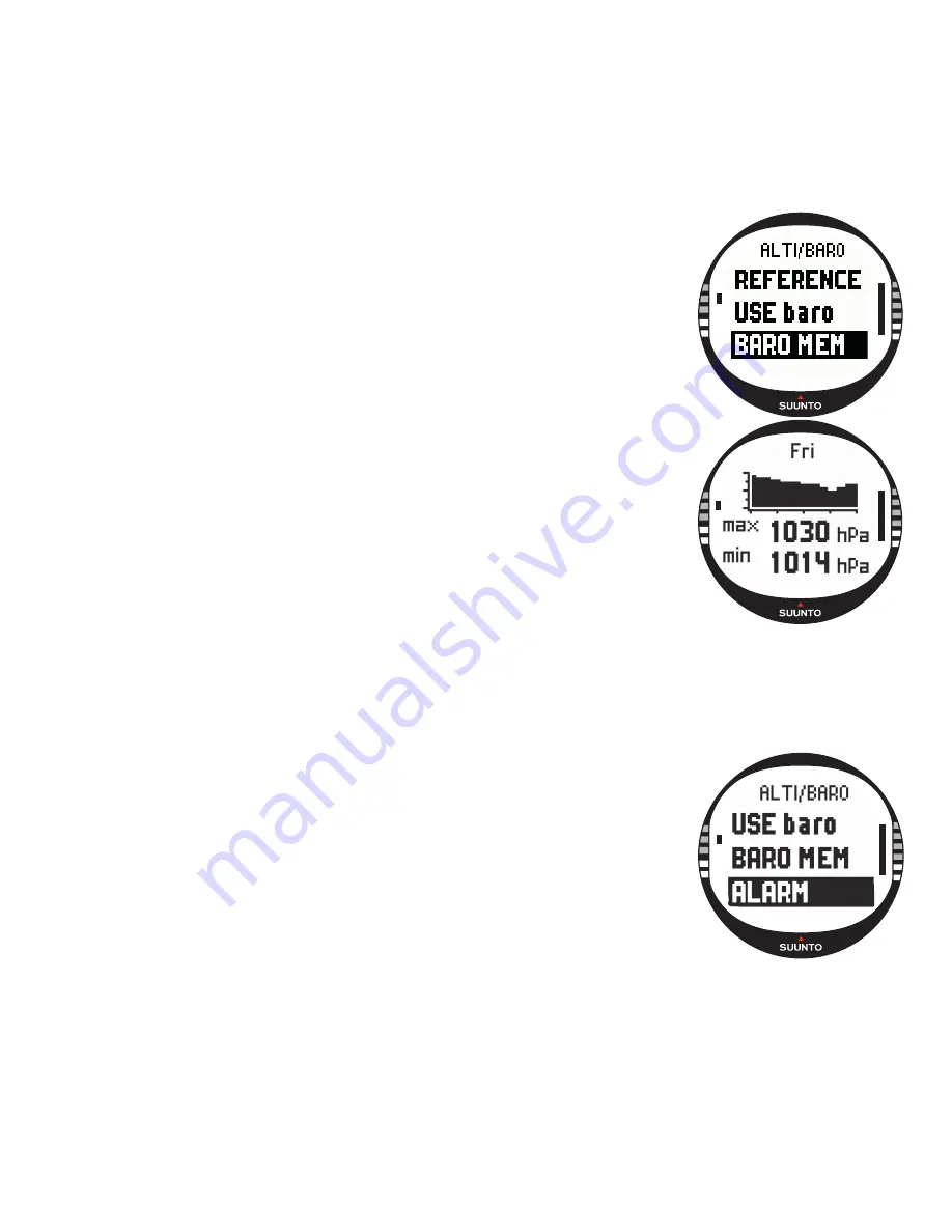
3.3.6. Barometric Memory

The Baro mem function stores weather-related information 
(sea level barometric pressure) from the last 7 days/168 
hours. 

To view the weather information:
1. In the Set menu, scroll to 

Baro mem

 with UP/DOWN and 

press ENTER. The first information page is displayed, and 
you can view the following information:
• Day
• A graphical presentation of the barometric pressure 

during the day

• Maximum barometric pressure during the day
• Minimum barometric pressure during the day

2. View the other days with UP/DOWN. The UP button scrolls 

forward and the DOWN button backward.

3. To stop viewing the memory content, press either ENTER 

or STOP/BACK at any time.

3.3.7. Alarm

With the Alarm function you can define two different alarms; 
altitude alarm and weather alarm. When you have set an 
alarm, its symbol appears on the display.

Weather Alarm

Suunto X10 checks the barometric pressure every 15 
minutes. The Baro Al function informs you when the 
barometric pressure changes more than 4 hPa (0.118 inHg) in 
3 hours. This is a typically used metheorological value for 
rapid weather change. 
When the GPS is on, the weather alarm is able to detect 
weather changes even when the altitude is changing.

Summary of Contents for X10

Page 1: ...EN SUUNTO X10 ...

Page 2: ...E GRAPH ALTITUDE BARO AL CREATE My Points ROUTE LIST NAVIDATA LIST MEMORY LIST GPS MARK Memp MARK HOME FIND HOME POSITION ROUTE INFO CREATE WP SELECT WP LIST ERASE VIEW EDIT LINK WP UPDATE ERASE SHORTCUTS SUMMARY SHORTCUTS SHORTCUTS DAY LIGHT SHORTCUTS SHORTCUTS route wp GPS refresh GPS refresh VIEW ERASE TRACK BACK TIME ALTI BARO COMPASS NAVIGATION ACTIVITY ALL MODES ENTER Short press ENTER Long ...

Page 3: ...ndicator 8 2 1 3 Alarm symbols 9 2 1 4 GPS reception indicator 9 2 2 MENUS 11 2 2 1 Basic menu structure 11 2 2 2 Press and long press 12 2 2 3 Navigating in the menus 12 3 MODES 13 3 1 GENERAL INFORMATION 13 3 2 TIME MODE 13 3 2 1 Main display 13 3 2 2 Stopwatch 14 3 2 3 Alarm 14 3 2 4 Time Date 16 3 2 5 Units 18 3 2 6 Setting the position format 21 3 2 7 General 23 3 3 ALTI BARO MODE 25 3 3 1 Us...

Page 4: ... 3 5 2 Main display 35 3 5 3 Creating a route 37 3 5 4 Using a route 39 3 5 5 Editing routes and waypoints 43 3 5 6 Navigation data displays 45 3 5 7 Navidata 47 3 5 8 Track Back Active track 48 3 6 ACTIVITY MODE 49 3 6 1 Main Display 49 3 6 2 Activity 50 3 6 3 GPS fix 51 3 6 4 Memory 52 3 6 5 Track back track log 54 3 6 6 Activity data display 55 3 7 FUNCTION MENU 56 3 7 1 GPS 56 3 7 2 Mark Memp ...

Page 5: ...ATION 69 6 2 SYSTEM REQUIREMENTS 69 6 3 PC INTERFACE 69 6 4 SUUNTO TREK MANAGER FEATURES 70 6 4 1 X10 window 1 71 6 4 2 Local Data window 2 72 6 4 3 Map window 3 74 6 4 4 Profiles window 4 75 6 4 5 Information window 5 75 6 4 6 SuuntoSports window 6 75 7 SUUNTO TRACK EXPORTER 76 7 1 INSTALLATION 76 7 2 SYSTEM REQUIREMENTS 76 7 3 EXPORTING DATA 76 8 THIRD PARTY MAPPING SOFTWARE 77 9 SUUNTOSPORTS CO...

Page 6: ...L GRID LIST 90 13 GLOSSARY 91 14 DISCLAIMERS 93 14 1 USER S RESPONSIBILITY 93 14 2 COPYRIGHT TRADEMARK AND PATENT NOTICE 93 14 3 CE 93 14 4 LIMITS OF LIABILITY AND ISO 9001 COMPLIANCE 93 14 5 AFTER SALES SERVICE 94 14 6 DISCLAIMER 94 15 DISPOSAL OF THE DEVICE 95 ...

Page 7: ...containing the Suunto Trek Manager software and the User s manual Suunto X10 Pocket Guide Suunto X10 User s Guide Should any of these be missing from the package contact the resale agent who sold you the package 1 2 CARE AND MAINTENANCE Only perform the procedures described in this manual Never attempt to disassemble or service your Suunto X10 Protect your Suunto X10 from shocks extreme heat and p...

Page 8: ...harge the battery approximately 500 times The life expectancy of a single charge can range from 6 hours with heavy usage of the GPS backlight compass and data storage functions to over 2 months if you only use Time and or Alti Baro mode When the battery level indicator on the display reaches the red zone the battery voltage is low and you should recharge the battery Do not attempt to replace the b...

Page 9: ... disconnect the charger from the mains outlet Your Suunto X10 is now ready for use 2 HOW TO USE YOUR SUUNTO X10 2 1 DISPLAY AND BUTTONS 2 1 1 Mode indicator On the left side of the display there is a mode indicator that shows you the currently active mode The mode indicator displays the modes from the top down in the following order TIME ALTI BARO COMPASS NAVIGATION and ACTIVITY The active mode is...

Page 10: ...e mode and wait a few minutes for the reading to stabilize 2 1 3 Alarm symbols Suunto X10 can display three different alarm symbols Time weather and altitude When you set a time alarm its symbol is displayed at the right side of the lower horizontal dot line When you set the weather alarm its symbol appears underneath the left side of the dot line When you set the altitude alarm its symbol appears...

Page 11: ...10 ...

Page 12: ...D ALARM LIST PRESSURE GRAPH ALTITUDE BARO AL CREATE My Points ROUTE LIST NAVIDATA LIST MEMORY LIST GPS MARK Memp MARK HOME FIND HOME POSITION ROUTE INFO CREATE WP SELECT WP LIST ERASE VIEW EDIT LINK WP UPDATE ERASE SHORTCUTS SUMMARY SHORTCUTS SHORTCUTS DAY LIGHT SHORTCUTS SHORTCUTS route wp GPS refresh GPS refresh VIEW ERASE TRACK BACK TIME ALTI BARO COMPASS NAVIGATION ACTIVITY ALL MODES ENTER Sho...

Page 13: ...an 2 seconds 2 2 3 Navigating in the menus To navigate in the menus 1 Scroll the menu items with the UP DOWN buttons located on the right side of Suunto X10 Three menu items are displayed at the same time The menu item that is currently active and can thus be selected is displayed in reversed color The indicator bar on the left side of the display shows the active mode 2 To move deeper in the hier...

Page 14: ...the maps you normally use 3 2 1 Main display When you select the Time mode the main display opens It has three rows Date The first row displays the date in the selected format For more information on changing the date format see section 3 2 5 Units Time The second row displays the time in the selected format For more information on changing between 12 and 24 hour displays see section 3 2 5 Units S...

Page 15: ...ect other shortcuts before resetting the timer NOTE The maximum time period you can record with the stopwatch is 20 hours 3 2 3 Alarm You can set three independent time alarms When the alarm is set the time alarm symbol appears on the main display Activating alarms To activate an alarm 1 In the Set menu Alarm is the first menu item Press ENTER to select it The Alarm menu displays the status of the...

Page 16: ...Alarm is the first menu item Press ENTER to select it 2 Scroll to the alarm you want to deactivate and press ENTER The alarm information is displayed and the On Off field is activated 3 Press either the UP or DOWN button to change the alarm status to Off and long press ENTER The alarm symbol disappears from the main display Acknowledging alarms When you hear the alarm you can acknowledge it by pre...

Page 17: ...t the symbol AM or PM is displayed on the left side of the last row For dual time the AM PM symbol is displayed on the right side of the time For more information on the 12 24 hour format see section 3 2 5 Units 3 Change the hour with UP DOWN and press ENTER The minute selection is activated 4 Change the minutes with UP DOWN and press ENTER If you are setting the time the seconds are activated Wit...

Page 18: ...atus with UP DOWN and long press ENTER The time synchronization is now set You return to the Time mode s main display UTC offset You can set the UTC offset at 0 5 hour intervals depending on the time zone For time zones other than Greenwich time GMT full or half hours you have to set the time manually and keep Sync off To set the UTC offset 1 In the Set menu scroll to Time Date and press ENTER 2 S...

Page 19: ...enu item Press ENTER to select it The time format field is activated 3 Select the desired time format with UP DOWN and press ENTER The time format is now set Setting the date format The date setting defines the format in which the date is displayed The possible formats are DD MM Day before the month 27 11 MM DD Month before the day 11 27 To change the date format 1 In the Set menu scroll to Units ...

Page 20: ...played The options are hPa and inHg To change the barometric pressure unit 1 In the Set menu scroll to Units and press ENTER The Units menu is displayed 2 Scroll to Press and press ENTER The barometric pressure unit field is activated 3 Select the desired unit with UP DOWN and press ENTER The barometric pressure unit is now set Setting the altitude unit The Altitude setting defines the unit in whi...

Page 21: ...hich the distance is displayed The options are kilometers km and miles mi To change the distance unit 1 In the Set menu scroll to Units and press ENTER The Units menu is displayed 2 Scroll to Distance and press ENTER The distance unit selection is activated 3 Select the desired unit with UP DOWN and press ENTER The distance unit is now set Setting the speed unit The Speed setting defines the unit ...

Page 22: ...ore information on different grids see the Local Grid List appendix To set the grid 1 In the Set menu scroll to Units and press ENTER The Units menu is displayed 2 Scroll to Grid and press ENTER 3 Select the desired grid with UP DOWN and press ENTER The grid format is now set 3 2 6 Setting the position format The Position setting defines the format in which position coordinates are displayed The s...

Page 23: ...llowing table shows you the possible position formats and whether they use a datum or a grid Set This means that you have to set the correct datum grid No adjustment required This means that this selection does not have any effect so you do not have to adjust it Pos format Datum Grid Deg Set No adjustment required Dm Set No adjustment required Grid No adjustment required Set UTM Set No adjustment ...

Page 24: ...ot switch on from any button or during an alarm To change the light settings 1 In the Set menu scroll to General and press ENTER The General menu is displayed 2 Light is the first menu item Press ENTER to select it The current light setting is displayed in reversed color 3 Select the suitable light setting with UP DOWN and press ENTER The light settings are now ready Setting the brightness This se...

Page 25: ... to Contrast and press ENTER The contrast setting is activated 3 Change the value with UP DOWN and press ENTER The contrast is now set Setting the tones Tones are the sounds that indicate that you have successfully pressed the buttons You can set the tones to On or Off To set the tones 1 In the Set menu scroll to General and press ENTER The General menu is displayed 2 Scroll to Tones and press ENT...

Page 26: ...hen the Alti use is active Suunto X10 assumes that all the barometric pressure changes are due to altitude changes Alti is intended for measuring altitude whenever you are on the move However since substantial barometric pressure changes can take place during a day you should compare the changes reported by Suunto X10 to well known references If these differ from each other too much the reason is ...

Page 27: ...choice For more information on setting the vertical speed unit see section 3 2 5 Units Altitude The second row displays your altitude from the sea level Shortcuts The third row displays alternatively the temperature absolute barometric pressure abs or time Change the displayed information with STOP BACK Temperature Displays the temperature in the unit of your choice For more information on definin...

Page 28: ...ute barometric pressure abs or time Change the displayed information with STOP BACK Temperature Displays the temperature in the unit of your choice For more information on defining the temperature unit see section 3 2 5 Units Absolute barometric pressure abs Displays the actual pressure in your current location Time Displays the current time 3 3 4 Alti Baro data display The Alti Baro data display ...

Page 29: ...o to the Position display and check the altitude with the GPS The longer the GPS is on the more accurate the altitude reading will be Setting the reference altitude To set the reference altitude 1 In the Set menu Reference is the first menu item Press ENTER to select it The reference menu opens 2 Altitude is the first menu item Press ENTER to select it The Altitude display opens The previously set...

Page 30: ...the other days with UP DOWN The UP button scrolls forward and the DOWN button backward 3 To stop viewing the memory content press either ENTER or STOP BACK at any time 3 3 7 Alarm With the Alarm function you can define two different alarms altitude alarm and weather alarm When you have set an alarm its symbol appears on the display Weather Alarm Suunto X10 checks the barometric pressure every 15 m...

Page 31: ...an alarm that informs you when you reach the set altitude To activate or deactivate the altitude alarm 1 In the Set menu scroll to Alarm with UP DOWN and press ENTER The Alarm menu opens 2 Altitude is the first menu item Press ENTER to activate it The Altitude alarm display opens and the On Off field is activated 3 Change the field to either On or Off with UP DOWN and press ENTER The altitude fiel...

Page 32: ...st row displays the cardinal and half cardinal point abbreviations Heading The second row displays the heading in degrees Shortcuts The third row displays alternatively the time the bearing lock or the bearing bea Change the displayed information with STOP BACK Time Displays the current time Bearing lock This feature helps you follow a certain bearing Rotate your Suunto X10 horizontally until the ...

Page 33: ...ss START DATA NOTE The X10 Military model can be set to display mils instead of degrees by using the Trek Manager SW 3 4 2 Calibrating the compass To ensure that the compass works properly you need to calibrate it Calibrate the compass If it does not seem to work well for example when it displays the wrong compass heading or the heading changes too slowly If your Suunto X10 has been exposed to str...

Page 34: ... 3 Declination You can set the compass declination manually or let the GPS do it The compass declination options are introduced in the table below Off Compass points to the magnetic north On Compass points to the geographic north based on the manually set declination Use this when you know the exact declination of the location Normally you can find this on a topographic map Auto Compass points to ...

Page 35: ... and press ENTER The GPS automatically sets the compass declination NOTE The GPS declination database is based on a global 4 degree latitude x 4 degree longitude grid 3 5 NAVIGATION MODE You should use the Navigation mode when you have a pre planned destination and you want to ensure that you will find it The mode includes all the typical GPS functions related to routes and waypoints You can creat...

Page 36: ...s set in the Activity mode The 1 sec setting updates the display constantly The 1 min setting updates the display once every minute and when you long press STOP BACK The manual setting updates the display every time you long press STOP BACK The main display has three rows and a circular bearing indicator Direction to waypoint If the GPS is on and it has a satellite fix the upper part of the displa...

Page 37: ...mated time to waypoint ttw Change the displayed information with STOP BACK You can select a shortcut from the NaviData function to replace the ttw For more information see Section 3 5 7 Navidata Time Displays the current time Bearing bea Displays the bearing to the next waypoint in degrees Time to waypoint ttw Displays the estimated travel time to the next waypoint based on the current speed NOTE ...

Page 38: ...ow opens and the field that shows the waypoint number is highlighted NOTE If the memory already contains 50 routes the device displays the message ROUTE MEMORY FULL NOTE The information on the waypoint window differs depending on the chosen Position format For more information see section 3 2 6 Setting the position format 3 Set the waypoint number with UP DOWN and press ENTER The number defines th...

Page 39: ...t date and time You can also select a name for the waypoints from the list The alarm point names differ a bit from the waypoint names in both the headings and the waypoint list After the order number the alarm point names have a colon and waypoint names a full stop Creating a new waypoint to a route by linking Using the Link WP function you can add a new waypoint with the help of an existing waypo...

Page 40: ...G ROUTELIST and then the list itself is displayed 2 Select a route with UP DOWN and press ENTER The waypoint list and the related functions are displayed NOTE If you long press ENTER your Suunto X10 activates the selected route immediately 3 Scroll to Select and press ENTER The route is loaded and you can view it on the Navigation data display Choosing the navigation method The Navigate function d...

Page 41: ...ol is displayed when you activate a single waypoint on the MyPoints route This navigation option is only available if you choose a waypoint from the MyPoints route NOTE In normal route navigation the unit automatically switches to the next waypoint when you arrive inside a 30 meter radius of the waypoint or pass it at a distance further than 100 meters of the perpendicular line to the route that g...

Page 42: ...lculated from the current location or if the GPS is off from the previous location Waypoint coordinates The coordinates of the selected waypoint NOTE The information on the waypoint window differs depending on the chosen Position format For more information see section 3 2 6 Setting the position format You can also activate an additional data display with START DATA The following information is di...

Page 43: ...ample to warn you about rocks and other hazards You can set 10 alarm points in the MyPoints function and also 10 for each route The alarm points for MyPoints are always active when the GPS is on The alarm points for each route are active when you navigate on the selected route When you enter the within the defined radius from the alarm point for example 0 10 km the alarm goes on When the alarm is ...

Page 44: ...ou can activate the additional data display There you can change the waypoint type and alarm distance 6 Press ENTER to accept the changes and return to the main display Updating the waypoint location With the Update function you can replace the coordinates of a waypoint with the coordinates of your current location provided that the GPS is on To update the waypoint location 1 In the Set menu scrol...

Page 45: ...ction 4 Press ENTER to confirm the action Suunto X10 displays the message ERASING ROUTE after which you return to the Route menu Erasing waypoints To erase a waypoint 1 In the Set menu scroll to Route and press ENTER The route list is displayed 2 Select a route with UP DOWN and press ENTER A list of waypoints is displayed 3 Select a waypoint with UP DOWN and press ENTER The waypoint menu is displa...

Page 46: ...activated a route If you try to use it before you have activated a route Suunto X10 asks you to activate one To open the displays press START DATA in the Navigation mode s main display Navigation methods and After you have selected a route and pressed START DATA you can see a summary page and the route waypoint data pages as many as there are waypoints and also alarm points stored on this route Yo...

Page 47: ...ormation is displayed depends on the selected navigation method With these navigation methods these pages display the information from the previous waypoint to the currently displayed wp With this navigation method these pages display the information from the current or last known location to the displayed waypoint Alarm points With alarm points these pages display the information from the current...

Page 48: ...t to select an item as a shortcut scroll to an item with UP DOWN and press ENTER You return to the Set menu and the item appears as a shortcut on the main display You can also select an item by long pressing ENTER After this you return to the main dislay 4 To exit the display without selecting a shortcut press STOP BACK Distance to finish dtf Displays the distance from the current location to the ...

Page 49: ...d press ENTER The message START TRACK BACK is displayed 2 Press ENTER to confirm the selection Suunto X10 takes you to the Navigation mode s main display and activates the navigation to the starting location The Track Back functions just like the navigation with the exception that you cannot view additional data displays The destination is displayed on the top row 3 To stop the Track Back navigati...

Page 50: ...ns The display is updated according to the selected GPS fix interval The 1 second setting updates the display constantly The 1 minute setting updates the display once every minute and when you long press STOP BACK The manual setting updates the display every time you long press STOP BACK The display has three rows Speed The first row displays the speed in the unit of your choice Distance traveled ...

Page 51: ...tion according to their previously adjusted settings The message LOG FILE STARTED is displayed This turns off the GPS and closes the total log The message LOG FILE STOPPED is displayed This turns off the GPS temporarily and adds distance information in the log The message LOG FILE PAUSED is displayed When you select the GPS is activated again and the recording continues from the previous position ...

Page 52: ...have selected the Manual or 1 min you can reactivate the GPS by pressing STOP BACK for more than 2 seconds This is possible in the following modes and functions Activity and Navigation main displays Find Home and Position Mark Memp and Mark Home activate the GPS automatically and after marking the point return to the previously selected GPS fix NOTE If you use the Manual or 1 min the GPS accuracy ...

Page 53: ...activity without GPS positioning set the GPS fix interval to Manual and start the activity 3 6 4 Memory The Memory function displays the amount of free memory and the list of log files To use the Memory function 1 In the Set menu select Memory with UP DOWN and press ENTER 2 Select the desired log file with UP DOWN and press ENTER Now you can either view the file or erase it ...

Page 54: ...Highest altitude high Lowest altitude low Total number of runs A run is a vertical movement of ascent and descent equaling 150ft 50m or more 2 Press STOP BACK to exit the log information Erasing log files Your Suunto X10 can store up to 25 log files in the memory When it is full you have to erase existing files to make room for new ones To erase a log file 1 Select Erase with UP DOWN and press ENT...

Page 55: ...displayed check that the activity is set to and that the unit has received the first satellite fix 6 Press ENTER to confirm the selection Suunto X10 takes you back to the Activity display and activates the navigation It will first guide you to the nearest waypoint and from there to the starting location The Track Back works just like the navigation with the exception that you cannot view additiona...

Page 56: ...is displayed on four pages The pages change automatically every 3 seconds after which the device returns to the Activity mode s main display To exit the display earlier press START DATA again You can view the following information in the Activity data display Maximum speed max Average speed avg Total ascent asc Total descent dsc Highest altitude high Lowest altitude low Total number of runs A run ...

Page 57: ...rrent location To mark a memory point 1 In the Function menu scroll to Mark Memp and press ENTER The possible name options are displayed 2 Select a suitable name or accept the current date time as the name and press ENTER The compass heading Estimated position error epe coordinates and the altitude of the location are displayed 3 When the EPE is small enough the location is marked automatically Th...

Page 58: ...king However this way the location information will be less accurate 5 When the home position has been successfully stored the unit displays WAYPOINT STORED If you don t see this message mark the home position again to be sure that you have the correct position stored in the unit 6 To exit the display and interrupt the function press STOP BACK NOTE Suunto X10 uses the GPS for guidance when you are...

Page 59: ...f the GPS is on the device displays the Find Home information immediately If the GPS is off it is automatically activated when you select the Find Home function In this case it takes a while before the information is displayed Meanwhile the message WAIT is displayed on the upper row 2 Use the bearing indicator to find the stored position 3 Press STOP BACK to exit the function You return to the Fun...

Page 60: ...very minute and when you long press STOP BACK The manual setting updates the display every time you long press STOP BACK To view the position 1 In the Function menu scroll to Position and press ENTER The following information is displayed Satellites Sat The first number is the number of satellites used in the positioning and the second is the number of currently visible satellites Epe Displays the...

Page 61: ...ifference in France is beforehand and adjusted it accordingly Then the GPS would have synchronized the time automatically However Mike can adjust the time pretty quickly since on his recent trip to Nepal he had to do it manually anyway because Suunto X10 cannot adjust the UTC to a 15 minute reading interval which is required in Nepal He checks the time and has plenty of time to catch the train to ...

Page 62: ...while he tightens his shoelaces checks his backpack and puts on his harness Mike has created the routes for both hiking days with Suunto Trek Manager and uploaded them on his Suunto X10 in advance Even though he does not really need a navigational aid since the weather is fairly clear and paths are clearly marked he nevertheless activates a route in the Navigation mode since it does not consume th...

Page 63: ...mode on so that the barometric pressure changes do not affect the altitude readings anymore Before hitting the sack Mike plans out the next day s activities He needs to get up early because he has a long way to travel So first he checks the time of sunrise with Start Data in the Alarm menu and then sets an alarm to wake him up just before dawn He also compares the altitude reading to the one on th...

Page 64: ...etting so that he does not need to look at the map too often Mike navigates using the Suunto X10 compass together with the uploaded routes the altimeter and the map Just like with a regular compass he checks from time to time that the compass works properly If the bearing indicator stops moving or the cardinal points seem to be in weird directions he calibrates the compass again Even though the we...

Page 65: ...64 Mike has planned the trip carefully trained meticulously on easier cliffs purchased proper equipment and learned how to use it He is now ready for the arduous journey that will take him to the top ...

Page 66: ...running Roger keeps an eye on his speed and follows the distance on the display On the eight kilometer mark he checks the current time by selecting it on the bottom row with STOP BACK Another press of the button brings the time from start on the display He keeps on running and checking these pieces of information every now and then On about three km intervals he takes a sip of sports drink and vie...

Page 67: ...orks 24 hours a day regardless of the weather It can provide service to an unlimited number of users and it is free of charge 5 1 HOW TO ENSURE GOOD POSITION MEASUREMENT Using the GPS receiver of your Suunto X10 is very easy For more information on the actual usage see Section 3 7 1 However ensuring good position measurement is a bit trickier This section contains instructions on how to achieve th...

Page 68: ...ide reception angle is necessary for the Suunto X10 to ensure fluent operation in all positions when the unit is worn around the wrist However due to the wide angle the sensitivity of reception is not as good as in hand held GPSs with a narrow radiation pattern To minimize the GPS initiation time hold the unit steady in one position with the display facing up and make sure you are located in an op...

Page 69: ...t important factor The best position estimate is obtained when satellites from four different directions and angles can be tracked In other words the less obstructed the receiver s view of the sky the better the accuracy Number of satellites being tracked To calculate a position a GPS receiver usually requires simultaneous reception from at least four satellites The more satellites there are the b...

Page 70: ...e check for updates regularly as new features are developed continuously 6 1 INSTALLATION To install Suunto Trek Manager 1 Insert the Suunto Trek Manager CD ROM into the drive 2 Wait for the installation to begin and follow the installation instructions NOTE If the installation does not start automatically click Start Run and type D setup exe 6 2 SYSTEM REQUIREMENTS Minimum CPU speed 350 Mhz 64 MB...

Page 71: ...e Suunto Trek Manager display is divided into six separate windows These windows are shown in the figure below and their functions are briefly introduced in the following sections For more detailed instructions see Suunto Trek Manager Help ...

Page 72: ...port that is not reserved by other applications or devices 2 Attach your Suunto X10 firmly to the data clip Plug the USB connectors Suunto X10 enters the PC Interface mode automatically 3 Open Suunto Trek Manager 4 Click Connect to X10 icon on the bottom left window and Suunto Trek Manager displays the contents of your Suunto X10 Tracks Routes MyPoints 5 To transfer data between your Suunto X10 an...

Page 73: ...that has one waypoint The route appears in the Information window where you can edit the coordinates and other data Delete selected item First select the items you want and then click on this icon to delete them from the STM memory Search This icon is useful if you have a large database and want to find a specific file quickly Click on the icon type the name of the file in the Search box and the f...

Page 74: ...or route Add alarmpoint Add alarm points in the selected folder or route Add media Add pictures movies and audio files in the selected folder tracks waypoints or routes Search Explained along with the other icons of the Local Data window Delete Delete the selected file or folder Add mempoint name group Add a new mempoint name group Print Print the selected map or route Add mempoint name Add a new ...

Page 75: ...alarm point to drawn route Click on this icon and then a location on the Map window to add an alarm point to the route Add point to folder Click on this icon to create a singular point that is not part of a route Add alarm point to folder Click on this icon to create a singular alarm point that is not part of a route Print map as it is now With this icon you can print the map in the map window Zoo...

Page 76: ...nces Zoom With this icon you can zoom in an out for a more in depth or general look 6 4 5 Information window 5 This window displays the detailed information on the routes waypoints settings etc you have activated in other windows 6 4 6 SuuntoSports window 6 From here you can easily access the SuuntoSports com website You can also upload your tracks routes and waypoints from the Local Data window b...

Page 77: ...Insert the Suunto Track Exporter CD ROM into the drive 2 Wait for the installation to begin and follow the installation instructions NOTE If the installation does not start automatically click Start Run and type D setup exe 7 2 SYSTEM REQUIREMENTS Minimum CPU speed 350 Mhz 64 MB of RAM 40 MB of available hard disk space Microsoft Windows 2000 Windows XP Windows Vista Minimum resolution 1024 x 768 ...

Page 78: ...tion is started automatically and the exported track is displayed on the Google Earth satellite image 6 The track logs are exported to the Temporary Places folder in the Google Earth application If you want to save the exported track logs you must save them in the My Places folder before exiting the Google Earth application You cannot save logs in Suunto Track Exporter 8 THIRD PARTY MAPPING SOFTWA...

Page 79: ...ftware delivered with the product to transfer the data from your PC to SuuntoSports Before becoming a registered member you can also log in as a guest to check what SuuntoSports com has to offer 9 1 GETTING STARTED To join SuuntoSports com 1 Install Suunto Trek Manager and ensure that your computer is connected to the Internet 2 Click the SuuntoSports com text in the SuuntoSports com window locate...

Page 80: ...s members resorts logs or just type in your own keywords to find what you need 9 3 MY SUUNTO My Suunto contains your personal information You can write an introduction of yourself to other members register your wristop computer list your sports activities and manage your membership profile When you upload Suunto X10 logs to SuuntoSports com with Suunto Trek Manager they are displayed on your My Su...

Page 81: ...ude sport specific news bulletin boards event calendars ranking lists and discussions In the forums you can suggest links to sports related websites and read travel reports written by other members Sport forums introduce interesting locations and resorts related to different sports You can rank the resorts and suggest your own favorites You can also view ranking lists from the SuuntoSports databas...

Page 82: ...hargeable battery Memory 50 routes a route can include up to 50 waypoints Total number of waypoints 500 25 tracks max 26000 track points Barometer Display range 300 to 1100 hPa 8 90 to 32 40 inHg Resolution 1hPa 0 05 inHg Altimeter Display range 500 m to 9000 m 1500 ft to 29500 ft Resolution 1 m 3 ft Thermometer Display range 20 C to 60 C 5 F to 140 F Resolution 1 C 1 F Compass Resolution 1 GPS Re...

Page 83: ...setting the correct GPS datum see section 3 2 5 Units Number Name Description Datum 000 ADI M Mean Solution Ethiopian and Sudan 001 ADI E Burkina Faso 002 ADI F Cameroon 003 ADI A Ethiopia 004 ADI C Mali 005 ADI D Senegal 006 ADI B Sudan 007 AFG Somalia 008 ARF A Botswana 009 ARF H Burundi 010 ARF B Lesotho 011 ARF C Malawi 012 ARF D Swaziland 013 ARF E Zaire 014 ARF F Zambia 015 ARF G Zimbabwe 01...

Page 84: ...CK Namibia 038 SRL Sierra Leone 039 VOR Algeria 040 AIN A Bahrain Island 041 AIN B Saudi Arabia 042 BAT Sumatra 043 EUR H Iran 044 HKD Hong Kong 045 HTN Taiwan 046 IND B Bangladesh 047 IND I India and Nepal 048 INF A Thailand 049 ING A Vietnam 050 ING B Con Son Island Vietnam 051 INH A1 Thailand 1997 052 IDN Indonesia 053 KAN Sri Lanka 054 KEA West Malaysia and Singapore 055 KGS Korean Geodetic Sy...

Page 85: ...ia 070 EUR M Mean Solution Europe 1950 071 EUR A Western Europe 1950 072 EUR E Cyprus 073 EUR G England Channel Islands Scotland and Shetland Islands 074 EUR K England Ireland Scotland and Shetland Islands 075 EUR B Greece 076 EUR I Italy Sardinia 077 EUR J Italy Sicily 078 EUR L Malta 079 EUR C Finland and Norway 080 EUR D Portugal and Spain 081 EUS Mean Solution European 1979 082 HJO Iceland 083...

Page 86: ...s 103 NAS V Aleutian islands East of 180deg W 104 NAS W Aleutian islands West of 180deg W 105 NAS Q Bahamas excluding San Salvador Island 106 NAS R San Salvador Island 107 NAS E Canada Mean Solution including Newfoundland 108 NAS F Alberta and British Columbia 109 NAS G Eastern Canada 110 NAS H Manitoba and Ontario 111 NAS I NW Territories and Saskatchewan 112 NAS J Yukon 113 NAS O Canal Zone 114 ...

Page 87: ...via 131 PRP B Northern Chile near 19deg S 132 PRP C Southern Chile near 43deg S 133 PRP D Colombia 134 PRP E Ecuador 135 PRP F Guyana 136 PRP G Peru 137 PRP H Venezuela 138 HIT Southern Chile near 53deg S 139 SAN M Mean Solution 140 SAN A Argentina 141 SAN B Bolivia 142 SAN C Brazil 143 SAN D Chile 144 SAN E Colombia 145 SAN F Ecuador excluding Galapagos Islands 146 SAN J Baltra Galapagos Islands ...

Page 88: ...eeward Islands 163 NAP Trinidad and Tobago 164 FLO Corvo and Flores Islands Azores 165 PLN Canary Islands 166 POS Porto Santo and Maderira Islands 167 PUR Puerto Rico and Virgin Islands 168 QUO South Greenland 169 SAO Sao Miguel Santa Maria Islands Azores 170 SAP East Falkland Island 171 SGM Salvage Islands 172 TDC Tristan Da Cunha 173 ANO Cocos Islands 174 GAA Republic of Maldives 175 IST Diego G...

Page 89: ...d 194 LUZ B Mindanao Island 195 MID Midway Islands 196 OHA M Mean Solution Old Hawaiian 197 OHA A Hawaii 198 OHA B Kauai 199 OHA C Maui 200 OHA D Oahu 201 PIT Pitcairn Islands 202 SAE Espirito Santo Island 203 MVS Viti Levu Island Fiji Islands 204 ENW Marshall Islands 205 WAK Wake Atoll 206 BUR Bungka and Belitung Islands 207 CAZ Camp McMurdo Area Antarctica 208 EUR S Iraq Israel Jordan Lebanon S ...

Page 90: ...16 VOI 2 Tunisia Algeria 217 YAC Uruguay 218 RT90 Sweden 254 KKJ Kartta Koordinaatisto Järjestelmä Finland 255 WGS84 Global WGS84 coordinate system This is the default datum and the most widely used degree based coordinate system ...

Page 91: ...an activate grids with Suunto X10 or Suunto Trek Manager For information about setting the correct local grid see section 3 2 5 Units Name Description Finnish Finnish National grid KKJ 27 Swedish Swedish national map projection RT 90 British British National grid Swiss Swiss National grid Irish Irish National grid NZTM New Zealand Transverse Mercator Projection Dutch Royal Dutch grid BNM M28 Austr...

Page 92: ...ea to be carried out in a consistent and accurate manner Every map has a datum or metric grid You have to set your Suunto X10 to the correct datum grid for it to function properly with the map Distance from start dfs Traveled distance from the start point Distance to finish dtf Distance from the current location to the last waypoint on the route via each waypoint Distance to waypoint dtw Distance ...

Page 93: ...next waypoint based on the current speed UTC offset UTC means Universal Time Coordinated There are 25 standard time zones around the world that are all an integer offset of hours to UTC time If UTC time is 12 00 Noon PM then people having offset 5 hours have local time 17 00 or 5 00 PM There are also some countries places not using the standard time zones they might be e g 5 hours and 45 minutes a...

Page 94: ...Oy Suunto Suunto X10 and their logos are all registered or unregistered trademarks of Suunto Oy Google Earth and its logos are registered or unregistered trademarks of Google Inc All rights are reserved While we have taken great care to ensure that information contained in this documentation is both comprehensive and accurate no warranty of accuracy is expressed or implied Its content is subject t...

Page 95: ... be ISO 9001 compliant in all SUUNTO Oy s operations Quality Certificate No 96 HEL AQ 220 14 5 AFTER SALES SERVICE If a claim under warranty appears to be necessary return the product freight prepaid to your Suunto dealer who is responsible for having your product repaired Include your name address proof of purchase and or service registration card as required in your country The claim will be hon...

Page 96: ...locating the equipment Consult an authorized Suunto dealer or other qualified service technician if you cannot correct the problem Operation is subject to the following conditions 1 This device cannot cause harmful interference 2 This device must accept any interference received including interference that may cause undesired operation Repairs should be made by authorized Suunto service personnel ...

Page 97: ...Suunto Canada ...

Page 98: ...Suunto Oy 7 2008 ...

Reviews: