c) Navigation
The navigation with the NDrive is always made according to a starting point. That starting point is
given by the satellite signal. When there's no satellite signal, the starting point is given by the map's
central point.
Note: If you don't have a GPS signal and want to demonstrate a route from A to B,
do the search of a POI or an address (Starting Place). Return to the main menu and
navigate now to the point you wish to be your destiny.
Likewise, with no GPS signal, navigation is replaced by a route demonstration.
-
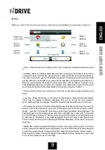
Navigation window
The navigation window has some similarities with the map window but adds a bar at the top with
indications relating to navigation, namely, next route instruction, distance till the next route instruction,
total time to destination and total distance to destination. The window has also the capacity to make
"auto-zoom" (depending on the travel speed) and rotate (allowing the navigation to be done always
upwards, independently of the compass). By clicking the context and home buttons, the menus
presented are also different.
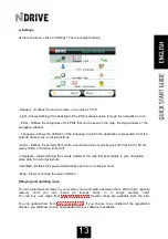
The context menu allows executing some settings that you may also define from the main menu settings
menu . The sole exception is the auto-zoom button, which can not be found on any other menu. The auto-
zoom button allows that the map, while navigating, adjusts to the most appropriate zoom to navigation if
activated. If you make a zoom in or a zoom out of the map, it will turn to the zoom considered ideal for
navigation in a few seconds.
Next route
instruction
Total time to
destination
Total distance
to destination
Speed Limit
10
Summary of Contents for NS 35-50 -
Page 1: ......
Page 2: ...2...
Page 28: ...28...
Page 37: ...In questo modo ha creato una nuova categoria come p o verificare nell immagine successiva 37...
Page 40: ......


