
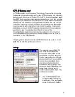
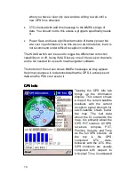

(UTC) which used to be called GMT (Greenwich Mean Time). The
time is computed at longitude 0 which passes through England.
California is 8 hours later than UTC (7 hours during DST).
The other information shown includes the Velocity (Speed and
Direction) and the Position (Latitude and Longitude) except that
altitude is missing.
The rest of the text is concerned with the quality of the fix itself. The
Status reports that the GPS has a 3D solution which means it is
computing a solution in all three axes which requires at least 4
satellites. In addition it is showing a HDOP, Horizontal Dilution of
Position and a PDOP (Point DOP). Dilution of Position is a unitless
number that represents how good the solution is based on the
current satellite positions. For horizontal DOP any number less than
2.0 is very good. PDOP provides a number that includes both
horizontal and vertical accuracy and 3.0 as shown above is a good
number for this. This computation is based strictly on the
arrangement of satellites as shown on the screen. Numbers above
6.0 would indicate a poor arrangement that might not lead to very
accurate results.
The bar chart at the bottom of the screen shows the S/N ratio of
each satellite (signal strength) and the blue bar indicates the
satellites that are contributing to the current solution. The numbers at
the bottom of the bar are the same numbers as the one on the map
so that the two charts can be tied together. The receiver is getting a
signal from satellite 6 but does not have the data yet to use it as part
of the solution.
By the way, the map of the earth shown on the upper chart is bogus
since the satellite view is looking up, not down with the center of the
circle representing the current location and North at the top. The
map itself is only a graphic and provides only misinformation but
looks nice.
11


