14
Appendix A) COSPAS-SARSAT
*
System
**
The beginnings of SARSAT date back to 1970 when a plane carrying two U.S.
congressmen crashed in a remote region of Alaska. A massive search and rescue effort
was mounted, but to this day, no trace of them or their aircraft has ever been found. In
reaction to this tragedy, Congress mandated that all aircraft in the United States carry an
Emergency Locator Transmitter (ELT). This device was designed to automatically
activate after a crash and transmit a homing signal. Since satellite technology was still
in its infancy, the frequency selected for ELT transmissions was 121.5 MHz, the
international aircraft distress frequency. This system worked, but had many limitations.
The frequency was cluttered, there was no way to verify who the signal was originating
from, and most importantly, another aircraft had to be within range to receive the signal.
After several years, the limitations of ELTs began to outweigh their benefits.
At that time, a satellite based system was conceived. It would operate on a frequency
reserved only for emergency beacons (406 MHz), it would have a digital signal that
uniquely identified each beacon, and it would provide global coverage.
The SARSAT system was developed in a joint effort by the United States,
Canada, and France. In the United States, the SARSAT system was developed by
NASA. Once the system was functional, its operation was turned over to NOAA where
it remains today.
As the system began to take hold, more and more emergency beacons found
their way onto the market. ELTs continued to operate exclusively on 121.5 MHz, but
maritime beacons (EPIRBs) were being built that operated on 406 MHz. The U.S. Coast
Guard in their role as maritime search and rescue specialists immediately began to see
the benefits of 406 MHz, and in 1990, took proactive steps to bring it into widespread
usage. As a result, today there are over 33,000 EPIRBs in the NOAA 406 MHz
Registration Database.
A similar system, COSPAS, was developed by the Soviet Union. The four
nations, United States, Canada, France and the Soviet Union banded together in 1979 to
form COSPAS-SARSAT. In 1982, the first satellite was launched, and by 1984 the
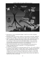
system was declared fully operational. A overview of this system is shown in the figure
on the following page.
The COSPAS-SARSAT organization also continued to grow. As of March,
2001, the four original member nations have now been joined by 34 other nations that
operate 38 ground stations and 15 mission control centers worldwide or serve as Search
and Rescue Points of Contact (SPOCs). COSPAS-SARSAT continues to be a model of
international cooperation. During the eighties, the Soviet Union and the United States
were able to put aside their Cold War differences and tackle some tough technical
questions.
Today, new technology continues to evolve and the member nations are
actively incorporating that technology into the COSPAS-SARSAT system of tomorrow.
The MicroPLB
TM
is at the forefront of this new technology revolution.
*
SARSAT: Search and Rescue Satellite-Aided Tracking
COSPAS: Space System for Search of Vessels in Distress
(acronym from the Russian language)
**
Parts abstracted from the NOAA SARSAT home page (
http://www.sarsat.noaa.gov
)
with thanks.

