background image

Magellan MAP 330 GPS Receiver

73

Appendix

Appendix

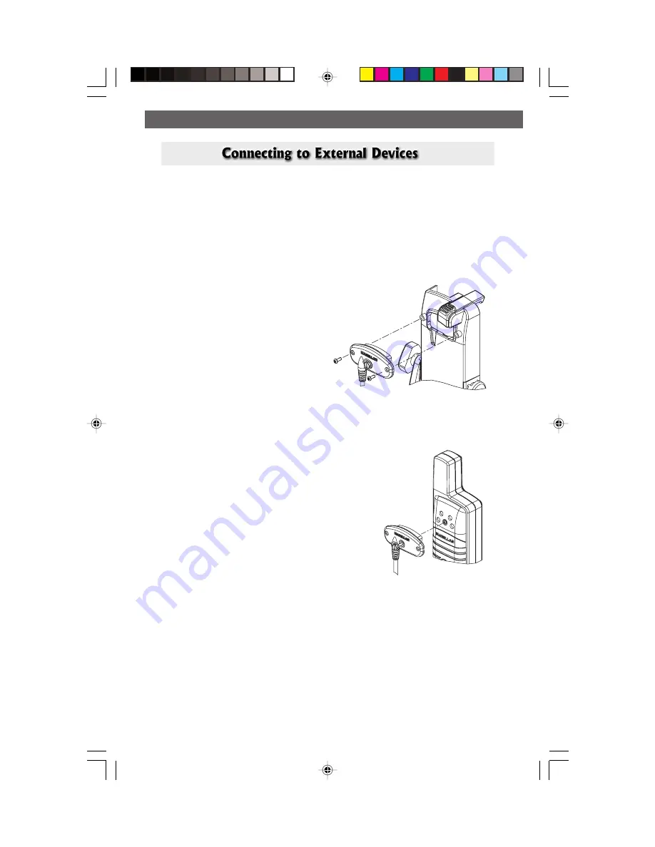
Available as accessories for your GPS receiver are the following cables:  External
Power Cable with Cigarette Lighter Adapter, Power/Data Cable, Data Cable and
PC Cable with Cigarette Lighter Adapter.  The instructions given below apply to
all cables, unless otherwise stated.

The cable can be connected to the receiver two different ways:

1.

Mount to the back of the
Swivel Mounting Bracket.

Using the two screws included,
attach the plug to the back of the
swivel mounting bracket.  It is not
necessary to tighten the captive
screw to the receiver, although
you may for added security.

2.

Mount to the back of the GPS receiver.

Using the captive screw that is attached to
the plug, tighten into the back of the
receiver (mounting screws are not used).

or

Summary of Contents for MAP330 - MapSend CD For Meridian

Page 1: ......

Page 2: ......

Page 3: ...Manual provides the instructions for using the Magellan MAP 330 and the Magellan MAP 330M GPS receivers Any reference to the MAP 330 in this User Manual applies to both receivers Those areas that app...

Page 4: ...ellan cables and antennas the use of non Magellan cables and antennas may severely degrade performance or damage the receiver and will void the warranty LICENSE AGREEMENT Magellan grants you the purch...

Page 5: ...3 PURCHASER S DUTIES To obtain service the purchaser must obtain a Return Materials Authorization RMA number from Magellan Corporation 800 707 7845 rma magellangps com prior to shipping If under warr...

Page 6: ...QUENTIAL DAMAGES WHATSOEVER ARISING OUT OF THE NEGLIGENT USAGE OF THE PRODUCT IN NO EVENT WILL MAGELLAN CORPORA TION BE RESPONSIBLE FOR SUCH DAMAGES EVEN IF MAGELLAN CORPORATION HAS BEEN ADVISED OF TH...

Page 7: ...ter Your Approximate Position 6 Basic Operation MAP 330 GPS Receiver 9 Turning Power On Off 10 Turning the Backlight On Off 11 Adjusting the Contrast 11 Getting a Position Fix 12 Navigational Screens...

Page 8: ...ty Definition 28 Turning Nav Info On Off 28 Selecting Street Information or Data Fields for Nav Information 29 Customizing the Data Fields 29 Data Field Options Definitions 30 Changing the Map Orienta...

Page 9: ...aypoint 42 Editing a User Waypoint 42 Viewing a Map Object on the Map 43 Viewing a User Waypoint on the Map 43 Saving a Map Object as a User Waypoint 43 Searching for a Street Address 44 Routes 45 Cre...

Page 10: ...lecting the Baud Rate 55 Clearing Memory 56 Clearing Track History 56 Clearing Wpts Routes 56 Clearing All Routes 56 Resetting MAP 330 to Factory Defaults 56 Clearing All Memory in the MAP 330 56 Sun...

Page 11: ...tor Off 60 Help 61 About 61 Frequently Asked Questions General 62 Waypoints Database 63 Navigation Screens 64 Routes 64 Alarms 64 Output Data 65 Appendix Troubleshooting 66 Waypoint Icons 67 Features...

Page 12: ...vi Magellan MAP 330 GPS Receiver...

Page 13: ...for under 100 to automotive receivers with turn by turn routing capabilities Before you begin make sure that your package includes all of the items listed on the side panel of the box If any of these...

Page 14: ...s containing information about connecting your MAP 330 to external devices accessories troubleshooting and specifications can be found in the Appendix Glossary A glossary is provided explaining some o...

Page 15: ...the new batteries as shown making sure that the batteries are installed with the correct polarity Replace the cover and tighten the battery door screw by turning it clockwise until the battery door i...

Page 16: ...n MAP 330 GPS Receiver Setting Up the MAP 330 Setting Up the MAP 330 The wrist strap attaches to the ring on the screw for the battery door cover The picture below shows how the wrist strap should be...

Page 17: ...e The reason for initialization is to speed up the process for computing the first position fix when the MAP 330 has no last position computed in memory i e when the MAP 330 is brand new or memory has...

Page 18: ...o highlight your general region Press ENTER Use the to highlight your area Press ENTER The cursor appears in the time field waiting for you to input your local time Set your local time using the arrow...

Page 19: ...s ENTER Pressing right arrow results in Pressing up arrow results in Editing moves the cursor block left or right To use the arrow keys to edit a field follow the simple diagram below increments the v...

Page 20: ...Up the MAP 330 The Sat Status screen is displayed and the MAP 330 is now ready to be used At this point you can begin using the MAP 330 beginning with the Basic Operation described in the next chapter...

Page 21: ...creen Press once to zoom one level press and hold to quickly move through the zoom levels OUT Zooms out the display of the Map screen Press once to zoom one level press and hold to quickly move throug...

Page 22: ...cessories for description of available cables Battery Cover Battery Cover Screw and Wrist Strap Ring Tuning the MAP 330 On Press Start up Screen displayed Warning Screen displayed ENTER Press You have...

Page 23: ...hold for 2 seconds Press hold for 2 seconds The backlight causes severe drain on the batteries in the MAP 330 To prevent accidently turning the backlight on and leaving it on the MAP 330 will turn the...

Page 24: ...ion Holding the MAP 330 The receiver is designed to fit comfortably in your hand Hold the MAP 330 in the palm of your hand with the antenna pointing towards the sky The MAP 330 has five navigation scr...

Page 25: ...for large display of the navigation data Ideal for when you have your MAP 330 mounted on the dashboard of a boat using the optional swivel mounting bracket Even from a distance the information can be...

Page 26: ...e that if you are inputting data pressing NAV will return you to the last navigation screen but your inputs will not be saved While viewing any navigation screen you can maneuver through the other scr...

Page 27: ...2 seconds and the Mark screen is displayed The Save button is highlighted and you can press ENTER to save the waypoint using the default name and icon You can later go back and edit any of the waypoin...

Page 28: ...ayed The very top of the keyboard window shows you what field you are changing in this case the Name field You can now use the arrow keypad to select the character you wish to enter With the character...

Page 29: ...nd press ENTER The keyboard window is displayed the same as when the Name was changed Only this time the top of the window says Message and the field you are typing into is larger to accommodate more...

Page 30: ...ith the MAP 330 in its built in database For example suppose you parked your car and planned on going hiking for about an hour And suppose that when you are done with your hike you want directions for...

Page 31: ...Highlight any category other than User and use the LEFT RIGHT arrows to select a Find By of Alphabetical Press ENTER In this example Cities was selected and this is how the screen appears This is a v...

Page 32: ...e cursor has moved to the second character in the list Press the UP arrow until the letter O is in the cursor Note that the MAP 330 skips over letters that have no corresponding waypoint in the list S...

Page 33: ...that display the information that you need in the layout that you desire Hikers may find the compass screen perfect for them while boaters may prefer the Large Data or Map screen For you the Map scree...

Page 34: ...e that the sun will rise and set along with lunar phase for a given position and date Best Hunting and Fishing Times Displays the best hunting and fishing times for a given position Real handy for hun...

Page 35: ...10 seconds ENTER Turn the MAP 330 Off Shuts down the MAP 330 Press ESC key to abort before 5 seconds has elapsed During the 5 second countdown pressing the PWR LIGHT key again will shut the MAP 330 of...

Page 36: ...Screen Sequence NAV ESC Returning to Last Viewed NAV Screen Pressing the NAV button returns the MAP 330 to the last NAV Screen viewed NAV Note if the NAV screen is pressed from a screen where data is...

Page 37: ...s width Scale can be changed with the IN and OUT buttons Track History Track History Track History Track History Track History Dotted line on the map displays the history of where you have travelled s...

Page 38: ...r Icon Cursor Icon Cursor Icon Cursor Icon Cursor Icon Cursor Icon The Cursor Icon pinpoints the location you have selected by using the arrow keys Map Scale Indicator Map Scale Indicator Map Scale In...

Page 39: ...iew more detail The default is Medium From the MAP Screen MENU ENTER ENTER NAV ENTER Highlight Map Setup Use arrows to highlight the Detail field Use arrows to select the desired Map Detail level Map...

Page 40: ...n of the city The four definitions the icon and the population size requirements are shown below Definition Icon Population Major City 500 000 Large City 100 000 Medium City 10 000 Small City 10 000 T...

Page 41: ...om of the screen displays the name of the street or intersection you are travelling on As you are travelling on a street the name of that street will be shown on the first line of the Nav Info box and...

Page 42: ...eing applied to arriving to your destination However if you are off course your VMG will be less than the speed that you are travelling CTS CTS Course To Steer This is the angle that you need to turn...

Page 43: ...ur travels or your track Turning On Off Track View Allows you to turn on or off the track history displayed on the map The track history can clutter up the map making some details difficult to see Tur...

Page 44: ...By deleting the track points that are stored you will be unable to perform a backtrack to any of these points Selecting Land or Marine Use As a default the MAP 330 is in the Land Mode In the land mod...

Page 45: ...uires you to be moving to be computed invalid data is indicated by dashes Compass Heading Marker Compass Heading Marker Compass Heading Marker Compass Heading Marker Compass Heading Marker Using the c...

Page 46: ...d can be selected from 13 different options Customizing is accessed through the MENU button Some of the data displayed requires you to be moving to be computed invalid data is indicated by dashes Data...

Page 47: ...tems that you have selected in Setup The Position 1 screen shows all of the basic position time and satellite information on one screen In addition current navigation information is shown in the botto...

Page 48: ...played GPS Status GPS Status GPS Status GPS Status GPS Status Provides information on the current status of the GPS receiver portion of the MAP 330 Data Fields Data Fields Data Fields Data Fields Data...

Page 49: ...on the Position screen Message Description Searching 1st sat Searching for 1st satellite Searching 2nd sat 1st satellite found searching for 2nd satellite Searching 3rd sat Two satellites are being tr...

Page 50: ...ute your position are shown with solid bars The height of the bar indicates the relative signal strength the higher the bar the stronger the signal Power Source Power Source Power Source Power Source...

Page 51: ...be presented with a list of waypoints that you can choose from The information at the bottom of the screen indicates the bearing and distance to the highlighted waypoint from your present position ENT...

Page 52: ...d you can use the Up Down arrows to highlight a waypoint and press ENTER to view information on it When highlighting a waypoint the bearing and distance from the cursor to the waypoint is displayed at...

Page 53: ...alize the waypoint making it easy to remember what it is Creating New Waypoint Manually Allows the creation of a new waypoint with coordinates other than your present position The coordinates for the...

Page 54: ...ht arrows select Find By ENTER Highlight User Select Waypoint to be Deleted MENU Highlight Delete WPT Confirm Yes or No ENTER Editing a User Waypoint Allows you to edit a waypoint that you have alread...

Page 55: ...sed in a route you will get a warning that it is in a route after selecting it from the list This is because the screen that you access the view button can also be used to edit the waypoint and it may...

Page 56: ...ble address range ENTER Use arrows to enter address number ENTER Use U D arrows to highlight Mark or View ENTER Mark If you select Mark and press ENTER the Edit Waypoint screen is displayed You can no...

Page 57: ...lso note that when you are selecting the Waypoint Category you are being instructed to select the Find By You can select only those waypoints in your general vicinity Nearest or all of the waypoints i...

Page 58: ...ext GOTO That means if you had three GOTO s one from A to B another from B to C and a third from C to D you could then put them together to make one multileg route In this example you would have a 3 l...

Page 59: ...ist Step 2 Select leg destination waypoint ENTER ENTER Select Waypoint Category Use left right arrows to select Find By ENTER Select Waypoint from List Use up down arrows to move highlight to next ava...

Page 60: ...ive Activate Route will be displayed Viewing a Route Allows you to view the legs of a route using the same screen that was used to create the route Viewing a route can be used if you just wanted to se...

Page 61: ...t the waypoint E between B and C you would highlight the waypoint C and follow the steps to insert waypoint E Your route would then be A to B to E to C to D A B E C D Deleting a Leg Deletes a leg from...

Page 62: ...sition user generated position or by using Map Cursor to locate position ENTER Select Route Edit Modify Waypoint as desired ENTER Highlight Routes Button Reversing a Route Allows any route in memory t...

Page 63: ...be saved to your route list with a naming convention of T01P01 to T01Pxx where Pxx indicates the number of points in the route From Any Screen MENU ENTER Highlight Routes Highlight Save Trk to Rte EN...

Page 64: ...press ESC before confirming all of the nav screens your selection will not be saved and the Sat Status screen will still be on Default All On Selecting the Coordinate System Allows you to set the coor...

Page 65: ...S84 Selecting the Elevation Mode Allows you to select the elevation mode used by the MAP 330 You may choose between 3D uses satellite information to compute elevation or 2D displays a fixed elevation...

Page 66: ...ows the selection of whether the MAP 330 uses True North or Magnetic North as its North reference From Any Screen MENU ENTER Highlight Setup ENTER Highlight North Reference Select North Reference ENTE...

Page 67: ...output from the MAP 330 Choices are Off V1 5 APA V1 5 XTE or V2 1 GSA Your choice will be dependent upon what message the device you are connecting to needs to receive From Any Screen MENU ENTER Highl...

Page 68: ...ing Wpts Routes This will clear all waypoints and routes from the MAP 330 s memory Clearing all Routes This clears all routes from the MAP 330 s memory Resetting MAP 330 to Factory Defaults Allows you...

Page 69: ...n Changing the Sun Moon Date Allows you to change the date for the sun moon information for the position selected From Any Screen MENU ENTER Highlight Sun Moon Highlight Date Field ENTER Use arrows to...

Page 70: ...nge the date for the fishing hunting information for the position selected From Any Screen MENU ENTER Highlight Fish Hunt Highlight Date Field ENTER Use arrows to change date ENTER Changing the Fish H...

Page 71: ...when you have drifted from your anchor point at a distance you set An example of its use would be as you set anchor you turn on the anchor alarm to beep at a given distance With the MAP 330 still ope...

Page 72: ...earing of Track Turning on the Simulator User Mode This turns the simulator on and uses a heading and speed rate that you define From Any Screen MENU ENTER Highlight Setup ENTER Highlight User ENTER H...

Page 73: ...l memory size of detailed maps you may have installed using MapSend Streets and how much free memory is available From Any Screen MENU ENTER Highlight About Help Screen You can view help tips for Nav...

Page 74: ...re using at the same time You should always make sure that your MAP 330 is setup to be the same as any map or chart you may be using What is 2D vs 3D The difference is primarily how many satellites ar...

Page 75: ...th the MAP 330 will have to search the sky trying to find any satellite that may be in view This takes time and can increase the time it takes to get its first position fix Can take 10 minutes in seve...

Page 76: ...allows you to retrace your steps As you are moving the MAP 330 automatically creates and stores hidden waypoints into memory These waypoints are the ones that the MAP 330 will use to retrace your step...

Page 77: ...g where you can purchase the NMEA Interface Standards Another excellent source for NMEA standards is a FAQ sheet that is published on the internet by Peter Bennett at vancouver webpages com peter nmea...

Page 78: ...on to avoid a similar occurrence Battery life seems shorter than it should be 1 Make sure that you are using two AA alkaline batteries 2 Shorter life span of the batteries can be due to excessive use...

Page 79: ...k Zoo Default Box House Aerial Airport Amusement ATM Auto Repair Boating Camping Exit Ramp First Aid Fixed Nav Aid Floating Buoy Fuel Garden Golf Hotel Hunt Fish Large City Lighthouse Major City Marin...

Page 80: ...wn further using the down arrow you will see the rest of the navaid categories Tips on Using the MAP 330M Loading maps from MapSend Streets CDROM provides more detailed coastlines which are useful for...

Page 81: ...er ship the receiver by Parcel Post or UPS Include a description of the problem your name address a copy of your sales receipt and print clearly on the outside of the package the RMA number assigned I...

Page 82: ...on 49 feet 15 meters RMS Velocity 0 1 knot RMS steady state Limits Speed 951 mph Altitude 17 500 meters Physical Size 6 2 x 2 0 x 1 3 h x w x d 15 75 cm x 5 08 cm x 3 30 cm Weight 7 ounces 198 45 gram...

Page 83: ...Leather Carrying Case The carrying case provides a way of carrying the MAP 330 on your belt while at the same time protecting it from the ele ments Power Data Cable Bare Wires Allows you to connect y...

Page 84: ...o the receiver Maps are not pre cut to counties or other boundaries Features Minimum Requirements IBM PC AT 486 or compatible 32 MB RAM VGA Video Card 60 MB Hard Drive Space 8x CD ROM drive MS Windows...

Page 85: ...es unless otherwise stated The cable can be connected to the receiver two different ways 1 Mount to the back of the Swivel Mounting Bracket Using the two screws included attach the plug to the back of...

Page 86: ...xternal power source The input voltage range for external power is 9 16 VDC Caution Do not bypass the power supply box or you will damage your unit and void the warranty Mounting Hole Power Supply Box...

Page 87: ...er to return to the course while proceeding towards the destination It is a compromise course bearing that projects from your current position to a point on the courseline midway between a point perpe...

Page 88: ...is from waypoint A to waypoint B to waypoint C to waypoint D has three legs with the first being from waypoint A to waypoint B Longitude The angular distance east or west of the prime meridian Greenw...

Page 89: ...n most large and intermediate scale land topographic charts and maps VMG Velocity Made Good The component of the velocity that is in the direction of the destination WPT Waypoint A location saved in t...

Page 90: ...een 13 33 customizing 34 Connecting to External Devices see External Connection Contrast 11 24 Contacting Magellan 69 Coordinate System 62 selecting 52 Cursor Mode 13 26 Database 18 39 using Nearest o...

Page 91: ...Map Object saving 43 viewing 43 Memory clear all 56 clear track 56 clear WPT routes 56 clearing routes 56 Messages entering 17 Messages GPS Status 35 36 NAV units selecting 54 Navigation Screens 12 24...

Page 92: ...un Moon screen accessing 57 date changing 57 position changing 57 Technical Support 69 Time setting 53 Time Format selecting 53 Track History display 31 clearing 31 56 mode 31 Trip Odometer 36 resetti...

Page 93: ......

Page 94: ...630800 A 960 Overland Court San Dimas CA 91773 909 394 5000...

Reviews: