GPS plotter
Ú
Note:
The GPS plotter page is not available on 4x Sonar only
models.
The GPS plotter page displays your vessel’s position. On the GPS
plotter page you can plan and navigate routes, see your vessel's
trail, and place waypoints.
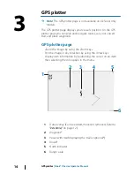
GPS plotter page
•
Zoom the image by using the Zoom keys
•
Pan the image in any direction by using the Arrow keys
•
Display item information by positioning the cursor on an item
then selecting the Info option in the menu
1
2
3
6
4
5
1
Data overlay (Can be edited, moved or removed. Refer to
"Data Overlay"
on page 12).
2
Waypoint*
3
Vessel with trail (displaying the trail is optional*)
4
Route*
5
North indicator
6
Range scale
3
14
GPS plotter
| Hook² X Series Operator Manual
Summary of Contents for HOOK2 X series
Page 1: ...ENGLISH Hook2XSeries OperatorManual 4xGPS 4xSonar 5xGPSHDI 7xGPSHDI www lowrance com...
Page 2: ......
Page 6: ...6 Preface Hook X Series Operator Manual...
Page 21: ...Waypoints Routes and Trails Hook X Series Operator Manual 21...
Page 32: ...32 Maintenance Hook X Series Operator Manual...
Page 33: ......
Page 34: ...988 11747 001...


