Kenwood DNX5240 Instruction Manual Download Page 25

English

25

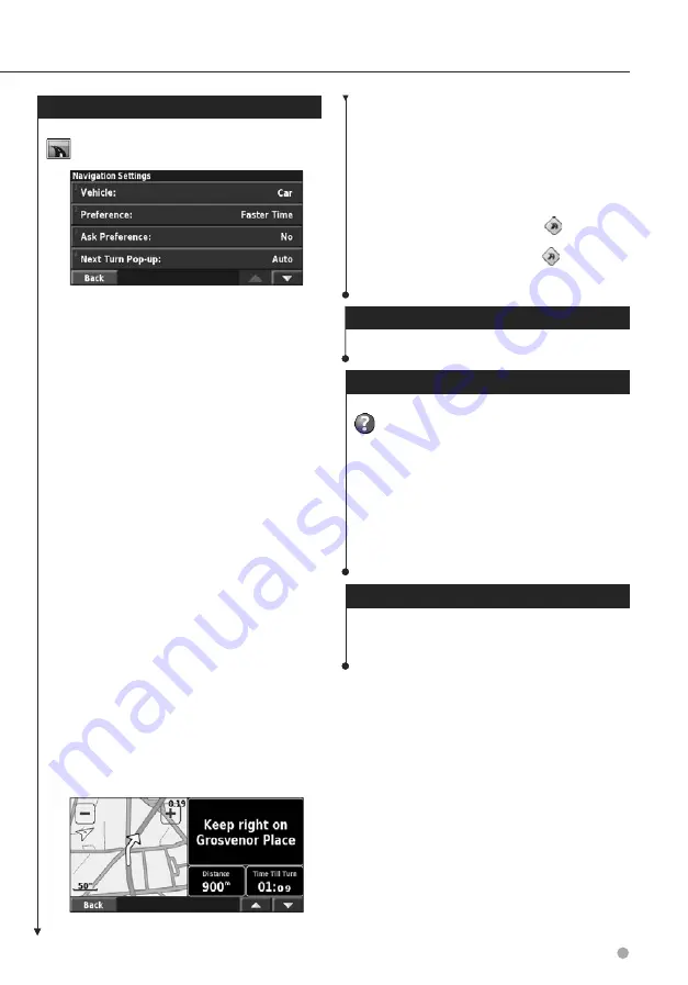
Changing the Navigation Settings

From the Menu page, touch 

Settings

 >

Navigation

.

Vehicle

—specify your vehicle type.

Preference

—select a preference for route calculations.

Preference

Description

Faster Time

Routes calculated with this setting are 
faster to drive but may be longer in 
distance.

Shorter Distance

Routes calculated with this setting are 
shorter in distance but may take more 
time to drive.

Off Road

Creates a direct-line route from your 
current location to your destination. This 
may be useful when you are traveling 
outside of detailed map coverage areas, 
or where no roads exist.

Ask Preference

—select whether the navigation system 

asks for your preference each time it calculates a route. 

Next Turn Pop-up

—select when the Next Turn page 

appears while navigating a route.

Preference

Description

On

The Next Turn page is displayed for 
every turn.

Auto

The Next Turn page is only displayed 
when you are not in the Map page, 
because you are already tracking your 
turns.

Off

The system does not switch to the Next 
Turn page for each turn.

Off-Route Recalculation

—set the way the navigation 

system responds when off the route. You can silence the 
“off-route, recalculating” message here. 

Continuous Auto Routing

—enable or disable the 

Continuous Auto Routing feature. This feature allows 
the navigation system to continually search for a better 
route to your destination. Continuous Auto Routing may 
be useful if a traffic accident occurs or there are time-
restricted turns on the current route. A 

 is displayed 

on the map when a better route than the one you are 
currently taking is available. Touch the 

 to take the 

better route. 

Avoidance Setup

—see

page 18

.

Adjusting the Traffic Settings

See 

page 21

.

Viewing Information (About)

Information (About)

From the Menu page, touch 

Settings 

>

About

.

Software

—the software version, audio version, unit

ID, and registration code for the unit are listed. The SiRF 
version being used in the GPS is also shown.

Detail Maps

—view information about the preloaded 

detailed maps.

FM Traffic Receiver

—view the FM Traffic Receiver unit 

ID.

Copyright Info

—view the copyright information 

relevant to the unit configuration.

Restoring the Settings

To restore the navigation system to its original 

settings, open the Menu page and touch 

Settings 

>

Restore Defaults

>

 Yes

.

Next Turn Page

Summary of Contents for DNX5240

Page 1: ...GPS NAVIGATION SYSTEM DNX5240BT DNX5240 GPS NAVIGATION INSTRUCTION MANUAL B64 4277 00 ...

Page 2: ...ng Saved Places 14 Editing Saved Places 14 Deleting a Saved Place 14 Creating and Editing Routes 17 Creating a New Saved Route 17 Editing a Saved Route 17 Adding an Intermediate Destination 17 Point to Your Route Saving the Active Route 17 Navigating a Saved Route 17 Recalculating the Route 17 Deleting All Saved Routes 18 Stopping Your Route 18 Adding a Detour to a Route 18 Adding Avoidances 18 Wh...

Page 3: ... Appendix 26 Using the Remote Control 26 Updating the Software 26 Updating the Map Data 26 Clearing All User Data 26 Custom POIs Points of Interest 26 Traffic Information 20 Viewing Traffic Events 20 Avoiding Traffic 20 Traffic Symbols 21 Changing the Traffic Settings 21 Adding a Traffic Receiver Subscription 22 Icons used in this manual Important precautions are described to prevent injuries etc ...

Page 4: ...he vehicle battery is disconnected GPS satellite signals will soon be received however and the correct position will be displayed Be careful of the ambient temperature Using the navigation system at extreme temperatures can lead to malfunction or damage Also note that the unit can be damaged by strong vibration by metal objects or by water getting inside the unit 2CAUTIONS Failure to avoid the fol...

Page 5: ...LATHE KS 66062 USA 3 Garmin EUROPE LTD LIBERTY HOUSE HOUNSDOWN BUSINESS PARK SOUTHAMPTON SO40 9RB UNITED KINGDOM OR 4 Garmin CORPORATION CUSTOMER SERVICE No 68 JANGSHU 2nd ROAD SHIJR TAIPEI COUNTY TAIWAN License Terms And Conditions Garmin we or us provides you with storage media containing the computer Software the Software and the embedded or accompanying digital map Data including any online or...

Page 6: ...sed in any commercial manner without the prior written consent of NAVTEQ Export Control You agree not to export from anywhere any part of the Data provided to you or any direct product thereof except in compliance with and with all licenses and approvals required under applicable export laws rules and regulations Indemnity You agree to indemnify defend and hold Garmin and its licensors including t...

Page 7: ...ervice Provider Garmin Ltd and its subsidiaries and their suppliers make no representations about content traffic and road conditions route usability or speed Garmin and its Traffic Service Provider s make no warranty of fitness or compatibility of the traffic data with the Garmin product and no warranty that the traffic data will operate properly as integrated and interfaced with the Garmin produ...

Page 8: ...em These steps normally have to be performed only once Select a language Select your current time zone Select whether you want your system to auto adjust for daylight saving time Select your preferred units of measure statute or metric The first time you use your Kenwood Navigation System you need to set up your system Getting Started ...

Page 9: ... It and Go Follow the instructions on the next two pages to find a place and go to it Finding a Restaurant 1 Touch Where To 2 Touch Food Hotel 3 Touch Food Drink 4 Touch a food category 5 Touch a place 6 Touch Go To ...

Page 10: ...ce prompts arrows and directions along the top of the map If you depart from the original route the navigation system recalculates the route and provides new route instructions Your route is marked with a highlighted line The default line color is green Follow the arrows A checkered flag marks your destination For more information about using the map and the other tools see pages 15 16 Find It and...

Page 11: ...ity if necessary 6 Select the address if necessary Touch Go To Finding a Place Using the Using the Map 1 From the Menu page touch View Map You can also touch Where to Browse Map Touch anywhere on the map to recenter the map on that location 2 Touch any object on the map Touch Review Where To The Where To menu provides several categories to help you quickly find your destination Use the Where To me...

Page 12: ... other options for this location Insert in Current Route add this point as the next stop in your route Add As Favorite add this location to your Favorites For more information see the next page Find Near Point find a location near this point Browse Map view this location on the map Finding Recently Found Places The last 50 places you have found are stored in Recent Finds 1 Touch Where To Recent Fi...

Page 13: ...ouch anywhere on the map 2 Touch Save As Favorite Setting a Home Location You can set a Home Location for the place you return to most often From the Menu page touch Where To 1 Touch Go Home 2 Select an option 3 Touch Save Home After you set your Home Location touch Where To and then touch Go Home My Locations You can save all of your favorite places in My Locations You can also save your home loc...

Page 14: ...ation of the place You can use the map or enter new coordinates using the keyboard Elevation enter the elevation of the saved place Category assign this place to a category Touch to view the categories Symbol select a symbol that is shown on the map for this location Deleting a Saved Place From the Menu page touch Tools My Data Favorites 1 Touch Delete Favorites 2 Touch By Selection By Selection t...

Page 15: ... The icon displays the current speed limit of the roadway Trip Computer The Trip Computer indicates your current speed and provides helpful statistics about your trip To view the Trip Computer select Trip Computer select Speed or Arrival on the map Or from the Menu page touch Tools Trip Computer 1 Current direction of travel 2 Current speed 3 Distance to your final destination 4 Total distance tra...

Page 16: ...left corner to view the GPS Info page Or from the Menu page touch Tools GPS Info 1 Sky view 2 Satellite signal strength bars The sky view shows the satellites you are receiving The satellite signal strength bars indicate the strength of each satellite you are receiving A solid bar indicates the GPS satellite is ready for use GPS Settings Settings From the Menu page touch Settings General GPS You c...

Page 17: ...ermediate destination points stops to your route as you create it You can also add points to your route when you edit the route as described below Follow the steps in the previous section to begin editing the route 1 Touch Edit Review Points 2 Touch Add 3 Touch where you to want to add the point 4 Touch a method and then select the point 5 Add points as necessary Touch Done when finished Auto Arra...

Page 18: ...avoid For example if the highway ramp is closed select the ramp in the list of roads The navigation system recalculates your route to avoid that ramp Detour by Traffic Event on Route if you are using an FM Traffic Receiver you can detour around traffic events Remove All Detours touch to remove any detours you have entered for the route Adding Avoidances Avoidances From the Menu page touch Settings...

Page 19: ... the map Select a zoom setting at which the track log is shown Touch OK Your track log is displayed as a narrow dotted line on the map Using the Mileage Logs You can keep four different mileage logs of your travels From the Menu page touch Tools My Data Mileage Log 1 Touch a log to edit it 2 Select an item to edit Name enter a new name Distance reset the mileage log Active make this log active or ...

Page 20: ...red cities refer to www garmin com fmtraffic Viewing Traffic Events From the Menu page touch Tools Traffic Info Select an item in the Traffic Events list to view the details Touch Near to view traffic at a different location 1 Traffic symbol 2 Color code 3 Traffic source FM Traffic and signal strength Avoiding Traffic The map page displays a when there is a traffic event of medium severity or high...

Page 21: ...st provider If you have a pay subscription Auto will connect to that service or it will tune to the free provider broadcasting the strongest signal Touch Advanced to clear the list of FM traffic providers or to search for available providers Subscriptions view your traffic subscriptions If you have an FM Traffic Receiver connected touch FM Traffic Subscriptions to view your subscriptions Touch the...

Page 22: ...ut FM Traffic Receiver and write down your FM Traffic Receiver s unit ID Go to www garmin com fmtraffic to purchase a traffic subscription and get a 25 character traffic subscription code 1 Touch Settings 2 Touch Traffic 3 Touch Subscriptions 4 Touch Add Subscription 5 Touch Next 6 Enter the code and touch Next 7 Touch OK Traffic Information ...

Page 23: ...the rate at which prompts are spoken Customizing the Keyboard Settings From the Menu page touch Settings General Keyboard Input Type select English Only keyboard or select Western European to use diacritical characters Entry Type select ABCDEF keyboard or select QWERTY Customizing the Audio Settings Audio Settings From the Menu page touch Settings General Audio Guidance turn on the vocal guidance ...

Page 24: ...m Auto Zoom distance from 120 feet to 300 miles Route Color select the color of the route line Dim Roads dim roads that are not on your route You can customize this setting to Never or While Routing Map Data Fields customize the width and the contents of the data fields displayed on the map page Normal is the default setting 1 From the Menu page touch Settings Map Map Data Fields 2 Touch Wide or T...

Page 25: ...n Off Route Recalculation set the way the navigation system responds when off the route You can silence the off route recalculating message here Continuous Auto Routing enable or disable the Continuous Auto Routing feature This feature allows the navigation system to continually search for a better route to your destination Continuous Auto Routing may be useful if a traffic accident occurs or ther...

Page 26: ...e new map data in your unit Clearing All User Data You can clear all user data including all favorite places routes custom POIs tracks mileage logs and your home location at one time 2CAUTION You cannot recover your user data after it is deleted 1 Touch Tools My Data Clear All 2 Touch Yes The navigation system restarts Custom POIs Points of Interest POIs Points of Interest You can manually load cu...

Page 27: ...ready saved in the system will be overwritten Finding Custom POIs To view a list of the custom POIs loaded in your navigation system touch Where To Extras Custom POIs Adjusting the Proximity Alerts To turn the proximity alerts for custom POIs on or off open the Menu page and touch Settings General Proximity Alerts Audio Notification turn the alerts that sound as you approach a custom POI on or off...

Page 28: ... Taiwan www garmin com Part Number 190 00902 00 Rev B Garmin and the Garmin logo are registered trademarks of Garmin Ltd or its subsidiaries and may not be used without the express permission of Garmin NAVTEQ is a trademark of NAVTEQ Inc or its affiliates and is registered in one or more countries including the U S All other company names and trademarks mentioned or referenced in this documentatio...

Reviews: