

a b o u t t h e f e a t u r e s
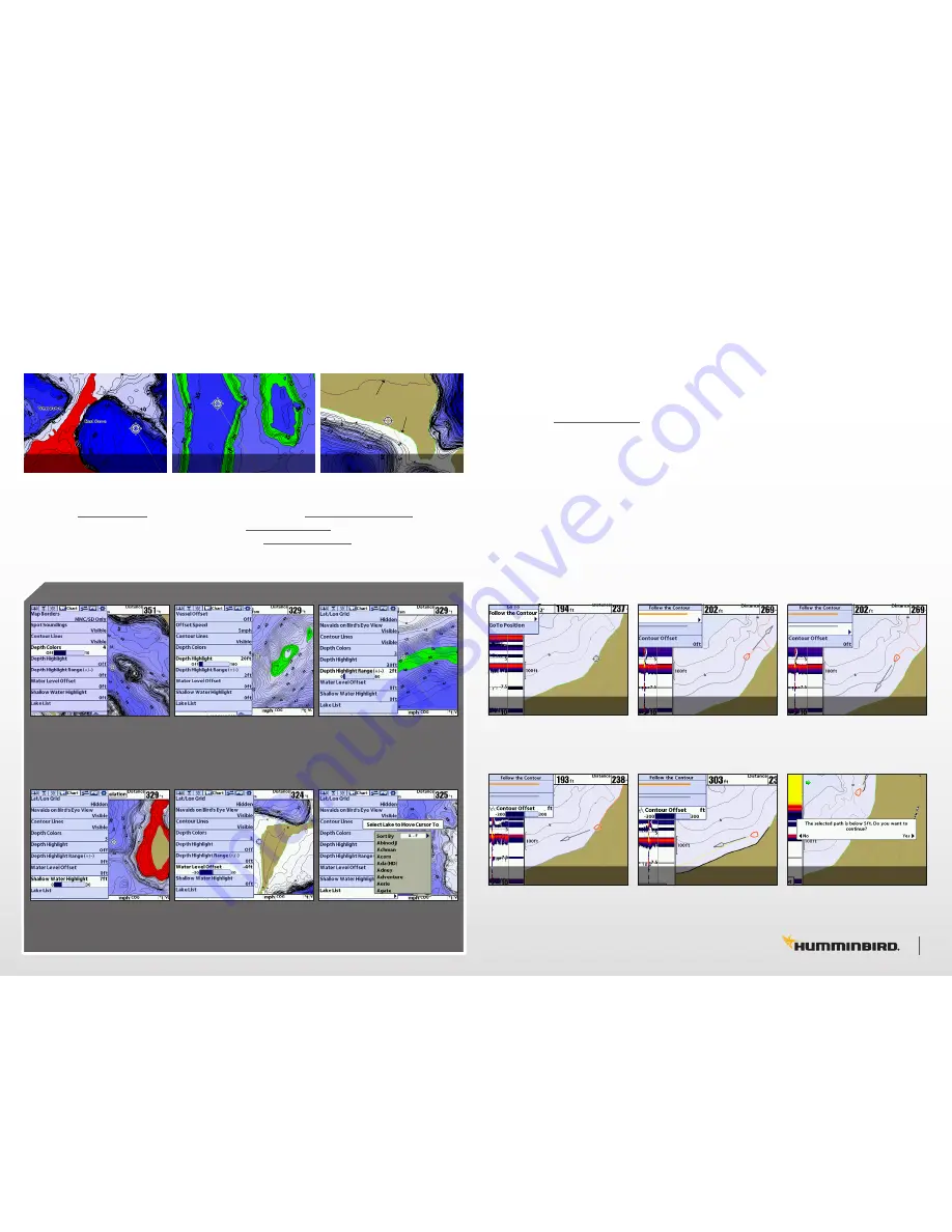
Revolutionary patented features offer new ways to enhance your fishing. Select a particular depth
range using Depth Highlight to keep you in the strike zone. Use Shallow Water Highlight to help
identify hazardous areas or shallow fishing water. Water Level Offset lets you adjust the chart to
the current water level. Can’t locate the lake? Use the Quick Find Lake List and your chart screen
will immediately go to your lake of choice.
Select the “Follow the Contour”
Menu option.
Select the “Contour Offset” to
offset your path from a contour
or the shoreline.
Select the orange line to follow
that direction.
Use Right Arrow Key ‘>’ to select
Once selected your boat will
begin navigating the path.
Select the gray line to follow
that direction.
Use Right Arrow Key ‘>’ to select
When navigating under 5ft you
must select ‘Yes’ or ‘No’ to
continue or abort your path.
shallow water highlight
depth highlight
new shoreline
previous shoreline
water level offset
features
features
SHALLOW WATER HIGHLIGHT
DEPTH HIGHLIGHT RANGE
DEPTH HIGHLIGHT
QUICK FIND LAKE LIST
DEPTH COLORS
WATER LEVEL OFFSET
Press Menu > Menu
Choose ‘Chart’ tab
Select ‘Depth Colors’
Press Menu > Menu
Choose ‘Chart’ tab
Select ‘Depth Highlight’
Press Menu > Menu
Choose ‘Chart’ tab
Select ‘Depth Highlight Range’
Press Menu > Menu
Choose ‘Chart’ tab
Select ‘Shallow Water Highlight’
Press Menu > Menu
Choose ‘Chart’ tab
Select ‘Water Level Offset’
Press Menu > Menu
Choose ‘Chart’ tab
Select ‘Lake List’
u s i n g i - p i l o t l i n k t o “ f o l l o w t h e c o n t o u r ”
1.
You must have a complete i-Pilot Link compatible system to enable this feature*. Power on the
Minn Kota trolling motor, insert the LakeMaster map card into your Humminbird Fishfinder, and
power on the unit. *For more information visit: http://www.humminbird.com/ipilotlink/
2.
When the Minn Kota i-Pilot Link trolling motor is deployed, “i-Pilot Link connected” will display
on the Humminbird Fishfinder screen.
3.
To start the Follow The Contour feature, move the cursor to the contour line you wish to
navigate, and click the “GOTO” button on the GPS unit.
4.
Select “Follow the Contour” menu option. See IMG. 1.
5.
Choose the direction of travel with either the orange or the gray navigation line, See IMG. 2, 3.
You can also choose to offset from any contour line or shoreline as well. See IMG. 4, 5.
6.
Once selected, your boat will begin to navigate the selected path after the trolling motor prop is
turned on. See IMG. 5.
7.
A warning message will appear on screen if your path moves below 5ft. Select ‘Yes’ or ‘No’ to
continue or abort your selected path. See IMG. 6. No matter the depth you choose, watch your
sonar for safe navigation and always check for obstructions on your path.
IMG.
1
IMG.
4
IMG.
2
IMG.
5
IMG.
3
IMG.
6
5 6
TM
®
®
®
®