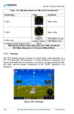
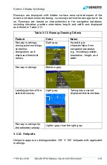


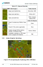

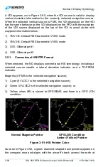
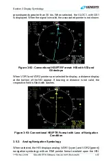
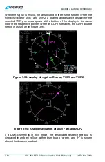


Section 3 Display Symbology
3-50
IDU-450 EFIS Software Version 8.0H (Rotorcraft)
1
st
Ed Nov 2018
NOTE:
See Section 8 Terrain Awareness Warning System for obstructions
causing TAWS alarms and depiction of separate symbology.
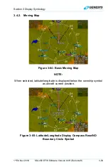
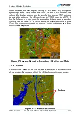
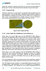
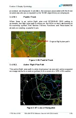
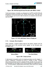
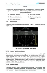
3.4.11. Pan Mode
The ND page has a pan mode for changing the location of the center of the
page away from current location and viewing map details along the route
of flight and at the intended or alternate destination while either in flight or
on the ground. When pan mode is active, use labeled buttons to pan
location north, south, east, and west in a north-up, centered orientation.
Upon entering pan mode, the heading pointer, track pointer, lubber line,
waypoint pointer, analog navigation symbology, and field of view lines are
removed from the display.
Figure 3-81 shows the line with bearing and distance from the map center
to the aircraft’s current position in white when the aircraft is more than 0.5
NM away. When panning, the nearest displayed airport, VOR, NDB, or fix
within the inner range ring is highlighted with a flashing circle. Buttons are
labeled to allow for viewing or hiding waypoint information (including
datalink weather information associated with that point). When exiting pan
mode, all previous settings are restored as before pan mode was enabled.
Figure 3-81: Pan Mode
3.4.12. Start Point
Activation of
NRST
or Direct -To function creates and activates a flight plan
from the present position to the selected waypoint. A waypoint named
“START” is placed at the current aircraft location when the flight plan is
created.