background image

4

Que for Palm OS - Applications Guide

O

VERVIEW

 > 

The QueMap application displays a detailed map of the area 

surrounding your current location.  It allows you to pan the map 

with the stylus as well as view your progress when navigating.  Your 

current location is shown as a solid black arrow.   As you travel to the 

edge of the display, the map moves (redraws) to constantly show your 

current location. When in the “Track Up” mode, a north reference 

arrow appears at the top left corner to orient the map. Use QueMap 

to: 

•  Determine your current location and view your movement
•  Locate and navigate to nearby map items
•  Follow a route line when navigating
•  Highlight and view information about locations on the map

To Display the QueMap Application:

There are three methods to open the QueMap Application. 

•  Press the Hard key you have assigned to the Que 

applications. 

•  Use the Left or Right Arrow keys to cycle through the 

Que applications until you reach QueMap.  

•  Use the Applications Launcher and tap the QueMap icon       

.      

Viewing the Map Page

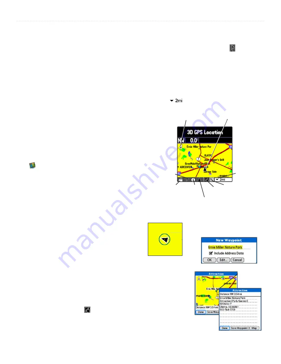
The Map Page is the primary screen of the QueMap application.  

From this page you can observe a triangular arrow that indicates your 

current location and direction of travel.  As you move, the arrow 

moves with you, turning when you turn and stopping when you 

stop. When zoomed in the accuracy of your location is indicated by 

an Accuracy Circle. The smaller the circle the more accurate your 

location.
The Map also displays detailed geographic information such as 

highways and roads, lakes and rivers, cities, waypoints and residential 

streets, depending on the detail of map data being used.  Detailed 

maps can be loaded from map data Disk’s using the Map Install 

feature as explained in the “Downloading Map Data” section of this 

guide.
There are two map orientation options: North Up and Track Up.  

North Up orients the map like a paper map, while Track Up orients 

the map in the direction of travel 

and can be set to display only 

below a desired map scale

.  As you travel to the edge of the 

display, the map moves (redraws) to constantly show your current 

location.  When using “Track Up”, the North arrow indicates the map 

orientation.
When the ‘Pan Map with Stylus’ mode   is selected, drag the stylus 

across the screen to pan the map with the movement of the stylus.
Tap the stylus on the map to place a map pointer on any selected 

location on the map.  If that location is supported by detailed mapping 

data, a description briefly displays.  Any point on the map can be saved 

as a waypoint by tapping the Waypoint marker flag   in the map 

toolbar.  
The map color can automatically compensate for the difference in day 

and night lighting conditions.  See “Using Preferences for QueMap”.
The map scale can be changed to show more map area with less detail 

or more map detail with less area (zoom out and zoom in).  Press the 

Up


and 

Down


keys on the front of the unit to increase and decrease 

the scale in single increments.  To select a specific scale, use the Map 

Scale Selector 

 shown at the top of this  page.

New Waypoint Page

Accuracy Circle 

The Map Page

Map Scale 

(Zoom 

Scale) 

View Area 

Selector

Position Arrow icon

Information

icon

Waypoint Flag 

(Mark Location 

icon)

Display 

Format 

icon

Pan Map 

with Stylus

Map 

Orientation

(North Up)

Current location icon

Position Arrow 

on Map

Map Point 

Information

Summary of Contents for Que

Page 1: ...Garmin Que GPS navigation software for Palm OS powered devices applications guide...

Page 2: ...roducts and to make changes in the content without obligation to notify any person or organization of such changes or improvements Visit the Garmin web site www garmin com for current updates and supp...

Page 3: ...n Que The operation of the Garmin Que application requires understanding of standard procedures used for the PDA that are not discussed in detail in the Garmin Que Application Guide If you purchased y...

Page 4: ...lways the user is responsible for their prudent use MAP DATA INFORMATION One of the goals of Garmin is to provide customers with the most complete and accurate cartography that is available to us at a...

Page 5: ...ld of airbag deployment Airbags expand with a rapid force that can propel objects in their path towards the vehicle driver or passengers causing possible injury Refer to airbag safety precautions cont...

Page 6: ...mats and Map Datums 6 Marking your current location as a waypoint 7 Using QueFind 8 Finding a City 9 Finding an Address 9 Finding an Intersection 10 Finding Points of Interest 11 Using Waypoints 11 Qu...

Page 7: ...that are blocking or deflecting satellite signals When operating on battery power the PDA normally turns off after the last key press to save power When connected to the GPS receiver it actually swit...

Page 8: ...Tap the under the Preferences tab to display the list of Que Preferences 4 Select Units to display the Units settings for Distance and Speed Elevation Depth and Direction values 5 Tap the beneath each...

Page 9: ...Button to access Garmin Que features Many PDAs have a four or five position button used for scrolling lists etc For our purposes we will refer to this button as the Arrow button You can use this butt...

Page 10: ...ential streets depending on the detail of map data being used Detailed maps can be loaded from map data Disk s using the Map Install feature as explained in the Downloading Map Data section of this gu...

Page 11: ...he map moves with the stylus and exposes the part of the map previously out of view Lift the stylus to stop panning To recenter your location on the map tap the Position Arrow icon Tap the View Area i...

Page 12: ...r Multimedia Card MMC See the Downloading Map Data section in this guide for more information on detailed map procedures The Miscellaneous preference options provide check boxes to allow you to turn o...

Page 13: ...the Waypoint Flag at the bottom of the map to display the New Waypoint window 3 Observe that the New Waypoint window has named the location as an address intersection or named map item if supported b...

Page 14: ...view an item from a QueFind Category 1 Once you have selected a category from the display of Find icons the Find Items List is displayed 2 You may choose a search method for an item If the map pointer...

Page 15: ...age Finding an Address To nd an address 1 From the QueFind application tap the Addresses icon to display the Addresses page 2 If you know the region state province city or postal code of the address e...

Page 16: ...en tap Use All 3 Tap the Street 1 eld to display the Select Street Name dialog box Begin entry of the street name When the desired name of the street is displayed tap it to select it Street names are...

Page 17: ...tegory from the All Types list 4 Tap the desired subject to display the re ned list 5 With the list displayed highlight a single Point of Interest item 6 Tap Details to display an information page sho...

Page 18: ...ociate with the waypoint 3 Tap the desired symbol and then tap OK to assign the symbol 4 Tap OK to use the selected symbol or Cancel to keep the current symbol To change the location of a waypoint 1 F...

Page 19: ...cludes an integrated phone press the phone Dial button 5 You are then prompted to con rm that you do want to dial the number 6 Select Yes to dial and if the phone is turned off select Yes when the Pho...

Page 20: ...o access the QueRoute Applications Press the assigned hard key repeatedly to cycle through the Que Applications until the QueRoutes application displays Use the Applications launcher to access the Que...

Page 21: ...ption to alter the route to avoid the roads used in the current route for a speci c distance To use the Detour option 1 Tap the QueRoutes icon 2 Tap the Detour option 3 Tap the distance to avoid roads...

Page 22: ...ows Saving a Route Once you have created a route to a destination while it is still active you can save it to the Saved Routes list for re use at a later date To Save a route 1 With a route active tap...

Page 23: ...lect from four options for recalculation noti cation Tap Help for de nitions 4 Tap the icon beneath the Turn Preview option to display and select from a list of methods for turn noti cation Tap Help f...

Page 24: ...linked with the remote GPS receiver and connected to external power the PDA remains on However when your PDA is using its battery it enters a low power mode and the display turns off after the time se...

Page 25: ...move to the map selection window 5 In the map selection window select a map region to download to your unit Use the map selection tool to click on the map areas that you want 6 Click Next to move to t...

Page 26: ...ghfares and secondary roads within metro areas Map Data Disks Accepts downloadable map detail from Garmin PC based MapSource City Select and City Navigator Data Disks which provide street level detail...

Page 27: ...You must enter the unlock code during MapSource Follow installation instructions on the setup installation disk Detailed Maps Don t Support Routing These maps are not the type used for auto routing Se...

Page 28: ...eason your Garmin GPS receiver when in the WAAS Enabled mode uses the method that achieves the best accuracy To enable disable WAAS refer to the General Settings tab of the System Setup Page of Garmin...

Page 29: ...CIDENTAL SPECIAL OR CONSEQUENTIAL DAMAGES WHATSOEVER INCLUDING BUT NOT LIMITED TO LOSS OF REVENUE OR PROFIT LOST OR DAMAGED DATA OR OTHER COMMERCIAL OR ECONOMIC LOSS EVEN IF WE HAVE BEEN ADVISED OF TH...

Page 30: ...Editing A Waypoint 12 Via Points on a Route 16 Elevation Altitude 12 Ending a Route Stop Navigation 15 F Faster Time Route 17 Find Applications Menus Addresses 9 All Points of Interest 11 Anchorage 11...

Page 31: ...eceiver Status 1 Recent Finds 8 Renaming Waypoints 12 Resuming Route Navigation 15 Routes Page 14 Route Preferences 17 S Satellite Information GPS Page 1 Saving Routes 16 Signal Strength 1 Software Li...

Page 32: ......

Page 33: ...51st Street Olathe Kansas 66062 U S A Tel 913 397 8200 Fax 913 397 8282 Garmin Europe Ltd Unit 5 The Quadrangle Abbey Park Industrial Estate Romsey SO51 9AQ U K Tel 44 0870 8501241 Fax 44 0870 8501251...

Reviews: