background image

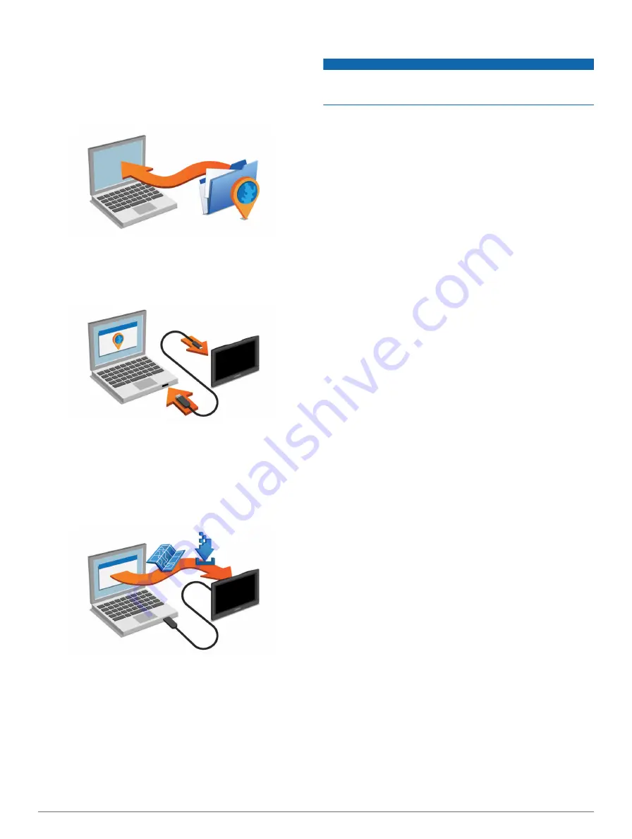
to your destinations. Garmin Express is available for Windows 

and Mac computers.

1

On your computer, go to 

www.garmin.com/express

.

2

Select an option:
• To install on a Windows computer, select 

Download for 

Windows

.

• To install on a Mac computer, select 

Mac Version

.

3

Open the downloaded file, and follow the on-screen 

instructions to complete the installation.

4

Start Garmin Express.

5

Connect your Garmin device to your computer using a USB 

cable.

The Garmin Express software detects your device.

6

Enter an email address for product registration (optional).

7

Click 

Save Device

.

8

Click 

Check for Updates

.

A list of available map and software updates appears.

9

Select the updates to install.

10

Click 

Install Now

.

The Garmin Express software downloads and installs the 

updates onto your device. Map updates are very large, and this 

process may take a long time on slower Internet connections.

Purchasing Additional Maps

1

Go to your device product page at (

www.garmin.com

).

2

Click the 

Maps

 tab.

3

Follow the on-screen instructions.

Safety Cameras

NOTICE

Garmin is not responsible for the accuracy of or the 

consequences of using a custom point of interest or a safety 

camera database.

Information about safety camera locations and speed limits is 

available in some areas. Go to 

www.garmin.com/safetycameras 

to check availability or to purchase a subscription or one-time 

update. You can purchase a new region or extend an existing 

subscription at any time.
You can update safety cameras for an existing safety camera 

subscription by going to 

http://my.garmin.com

. You should 

update your device frequently to receive the most up-to-date 

safety camera information.
For some devices and regions, basic safety camera data may 

be included with your device. Included data does not include 

updates or a subscription.

Custom Points of Interest

Custom POIs are customized points on the map. They can 

contain alerts that let you know if you are near a designated 

point or if you are traveling faster than a specified speed.

Installing POI Loader

You can create or download custom POI lists on your computer 

and install them on your device using POI Loader software.

1

Go to 

www.garmin.com/poiloader

.

2

Follow the on-screen instructions.

Using the POI Loader Help Files

For more information on the POI loader, refer to the Help file.

With the POI loader open, click 

Help

.

Finding Custom POIs

Before you can find custom POIs, you must load custom POIs 

on your device using the POI Loader software (

Installing POI 

Loader

).

1

Select 

Where To?

 > 

Categories

.

2

Scroll to the Other Categories section, and select a category.

Purchasing Accessories

Go to 

http://buy.garmin.com

.

Troubleshooting

My device is not acquiring satellite signals

• Verify the GPS simulator is turned off (

Navigation Settings

).

• Take your device out of parking garages and away from tall 

buildings and trees.

• Remain stationary for several minutes.

The suction cup will not stay on my windshield

1

Clean the suction cup and windshield with rubbing alcohol.

2

Dry with a clean, dry cloth.

3

Mount the suction cup (

Connecting the Device to Vehicle 

Power

).

The device does not charge in my vehicle

• Check the fuse in the vehicle power cable (

Changing the 

Fuse in the Vehicle Power Cable

).

• Verify the vehicle is turned on and is supplying power to the 

power outlet.

• Verify the interior temperature of the vehicle is between 32° 

and 113°F (between 0° and 45°C).

• Verify that the fuse is not broken in the vehicle power outlet.

12

Appendix

Summary of Contents for nuvi 150 series

Page 1: ...nüvi 140 150 series Owner s Manual March 2014 190 01517 00_0D Printed in Taiwan ...

Page 2: ...ct Garmin nüvi and the Garmin logo are trademarks of Garmin Ltd or its subsidiaries registered in the USA and other countries These trademarks may not be used without the express permission of Garmin BaseCamp HomePort MapSource myGarmin ecoRoute myTrends nüMaps Guarantee and nüMaps Lifetime are trademarks of Garmin Ltd or its subsidiaries These trademarks may not be used without the express permis...

Page 3: ... Transit Types 5 Navigating Off Road 5 Pedestrian Routes 5 Following a Pedestrian Route 5 Using the Pedestrian Navigation Map 5 Pedestrian Map Icons 5 Map Pages 5 Customizing the Map Layers 5 Viewing the Trip Log 5 Changing the Map Data Field 5 Changing the Map Perspective 5 Customizing Map Buttons 5 Changing the Map Dashboard 5 Viewing a List of Turns 5 Viewing the Entire Route on the Map 6 Viewi...

Page 4: ...ng Theft 11 Erasing User Data 11 Extending the Battery Life 11 Changing the Fuse in the Vehicle Power Cable 11 Mounting on Your Dashboard 11 Removing the Device from the Mount 11 Removing the Suction Cup from the Windshield 11 Updating Maps and Software with Garmin Express 11 Purchasing Additional Maps 12 Safety Cameras 12 Custom Points of Interest 12 Installing POI Loader 12 Using the POI Loader ...

Page 5: ...provides quarterly map updates for the useful life of your device For terms and conditions go to www garmin com us maps numaps _ lifetime LMT This model includes a nüMaps Lifetime subscription lifetime traffic subscription and a traffic receiver Activating Lifetime Maps NOTE Lifetime Maps are not applicable to products that do not have pre loaded maps NOTE Lifetime Maps entitle you to receive map ...

Page 6: ...e To Remove Shortcut s 2 Select the shortcut to remove 3 Select the shortcut again to confirm Finding Locations Locations The detailed maps loaded in your device contain locations such as restaurants hotels auto services and detailed street information You can use categories to browse for nearby businesses and attractions You can also search for addresses coordinates cities and intersections Findi...

Page 7: ...ic category of places Location markers or a blue dot appear on the map 4 Select an option Select a location marker Select a point such as a street intersection or address location 5 If necessary select the location description to view additional information Finding a Location Using Quick Search After you have performed a search for a point of interest certain categories may display a Quick Search ...

Page 8: ... location 3 Select Go Starting a Route to a Saved Location 1 Select Where To Saved 2 If necessary select a category or select All Saved Places 3 Select a location 4 Select Go Previewing Multiple Routes 1 Search for a location Finding a Location by Category 2 From the search results select a location 3 Select Routes 4 Select a route Automobile Routes NOTICE The speed limit feature is for informatio...

Page 9: ...p A smaller circle means the displayed position is more accurate The yellow icons indicate the navigation method used in each section of the route For example when you see you should board a bus at that point in the route The black dots on the map indicate public transit stops along your route Map Pages Customizing the Map Layers You can customize which data appear on the map such as icons for poi...

Page 10: ...Services You can use the Where Am I page to find nearby services such as fuel hospitals or police stations 1 From the map select the vehicle 2 Select a category Using the Apps Using Help Select Apps Help to view information about using the device Searching Help Topics Select Apps Help About ecoRoute The ecoRoute feature calculates the fuel economy and the fuel price of navigating to a destination ...

Page 11: ...ip leg select a leg and select Transportation Mode To view the trip on the map select Map Navigating to a Saved Trip 1 Select Apps Trip Planner 2 Select a saved trip 3 Select Go 4 Select your next destination and select Start Editing a Saved Trip 1 Select Apps Trip Planner 2 Select a saved trip 3 Select 4 Select an option Select Rename Trip Select Edit Destinations to add and delete a location or ...

Page 12: ... For information about traffic receivers and coverage areas go to www garmin com traffic A traffic receiver is included in some packages built into either the vehicle power cable or the device and is an optional accessory for all models Traffic alerts appear on the map when there are traffic incidents along your route or in your area The device must be connected to vehicle power to receive traffic...

Page 13: ...OI files from Garmin POI Loader Installing POI Loader About Memory Cards You can purchase memory cards from an electronics supplier or purchase pre loaded Garmin mapping software www garmin com In addition to map and data storage the memory card can be used to store files such as maps images geocaches routes waypoints and custom POIs Installing a Memory Card The device supports microSD and microSD...

Page 14: ...s fuel than other routes Off Road Calculates a direct line from your location to your destination Display Settings To open the Display settings page from the main menu select Settings Display Color Mode Sets the device to display day or night colors You can select Auto to allow the device to automatically set day or night colors based on the time of day Brightness Adjusts the display brightness Di...

Page 15: ...s to erase all user data All original settings are restored Extending the Battery Life Keep your device away from extreme temperatures Put the device in sleep mode Entering and Exiting Sleep Mode Decrease the screen brightness Display Settings Do not leave your device in direct sunlight Decrease the volume Adjusting the Volume Shorten the display timeout time Display Settings Changing the Fuse in ...

Page 16: ... safety camera information For some devices and regions basic safety camera data may be included with your device Included data does not include updates or a subscription Custom Points of Interest Custom POIs are customized points on the map They can contain alerts that let you know if you are near a designated point or if you are traveling faster than a specified speed Installing POI Loader You c...

Page 17: ...e device to fully discharge 2 Fully charge the device without interrupting the charge cycle My device does not appear as either a portable device or a removable drive or volume on my computer 1 Disconnect the USB cable from your computer 2 Turn off the device 3 Plug the USB cable into a USB port on your computer and into your device TIP Your device should be connected directly to a USB port on you...

Page 18: ... view 6 K keyboard 2 language 10 layout 10 L language 8 keyboard 10 voice 10 latitude and longitude 3 lifetime maps 1 locations 2 3 7 current 4 6 editing 2 recently found 3 saving 3 searching for 3 setting home 3 simulated 3 M map data field 5 pedestrian 5 map layers customizing 5 map perspective 5 map view 2 D 5 3 D 5 maps 4 10 browsing 3 data layout 5 detail level 10 layers 5 lifetime 1 nüMaps G...

Page 19: ...ubscriptions 1 searching for delays 8 9 transportation modes 2 travel history 11 trip computer 6 trip information resetting 6 viewing 6 trip log viewing 5 trip planner 7 editing a trip 7 troubleshooting 12 13 turn list 5 U unit converter 8 unit ID 11 up ahead finding services 5 updates maps 11 software 11 USB disconnecting 9 user data deleting 9 11 V vehicle power cable 1 vehicle profile 6 volume ...

Page 20: ... 02 36 699699 52 001 855 792 7671 0800 0233937 47 815 69 555 00800 4412 454 44 2380 662 915 35 1214 447 460 386 4 27 92 500 0861 GARMIN 427 646 27 0 11 251 9999 34 93 275 44 97 46 7744 52020 886 2 2642 9199 ext 2 0808 238 0000 44 0 870 8501242 49 0 180 6 427646 20 ct Anruf a d deutschen Festnetz Mobilfunk max 60 ct Anruf 913 397 8200 1 800 800 1020 2012 2014 Garmin Ltd or its subsidiaries ...

Reviews:

Related manuals for nuvi 150 series